Are disaster managers ready for the super El Niño hurricane season ahead?

NOAA forecasters are sounding the alarm: super El Niño is coming and it could mean record impacts during hurricane season—especially across the Eastern and Central Pacific basins...

By Chani Goering

05/12/2026
Hurricane Otis, fueled by the high sea surface temperatures of an ongoing El Niño season in 2023, made landfall in Acapulco, Mexico, causing devastation to the populous tourist destination.
Photograph: New York Times
NOAA forecasters are sounding the alarm: super El Niño is coming, and it could mean record impacts
during this year’s hurricane season—especially across the Eastern and Central Pacific basins. While El Niño hurricane seasons in the Atlantic are normally quieter than average, that’s not always the case, as with the El Niño of 2023, which saw a record-breaking 20 named storms and 7 hurricanes.

Disaster managers should plan now to face compressed hurricane response timelines and compound, cascading events like flooding, landslides, and other secondary impacts. Systems not equipped to deal with simultaneous events have a high potential to become overwhelmed.

According to NOAA, warm waters resulting from a 2026 super El Nino could potentially supercharge hurricane activity in the Eastern Pacific, saying the first tropical system could form as early as mid-May, 2026.
Photograph by NOAA
“What separates agencies that thrive during a super El Niño hurricane season from those that struggle isn’t speed during the crisis—it’s the work done before it to understand worst-case scenarios, catalog critical assets, and leverage risk intelligence tools like DisasterAWARE. Exercising those tools and staff in multi-jurisdictional coordination weeks or months in advance is what gives leaders the decision advantage when the first major storm system develops,” said Dr. Erin Hughey, Deputy Executive Director of Pacific Disaster Center (PDC).

Advanced technologies like DisasterAWARE are designed to help decision makers not only monitor early storm formations but also anticipate what these storms mean for communities and how to act effectively to mitigate multi-hazard impacts.

“What separates agencies that thrive during a super El Niño hurricane season from those that struggle isn’t speed during the crisis—it’s the work done before it…”

Satellite image of record-breaking trio of Pacific hurricanes, Kilo, Ignacio, Jimena, and Tropical Depression 14E forming to the East during the 2015 El Niño season. That year, an extraordinary 16 tropical cyclones formed in or passed through the Pacific basin, including three Category 4 storms in late August alone.
Photograph by NOAA
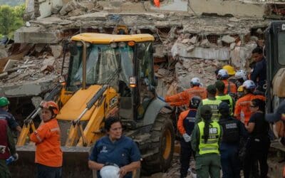
According to Hughey, communities and infrastructure may be exposed to unusual levels of precipitation, winds, and secondary hazards. Pointing to the recent historic flooding disaster across Hawaiʻi in March 2026, Hughey emphasized this is just a preview of what similar or stronger El Niño-fueled storms could unleash on communities later this year.

Super El Niño hurricane risks include:

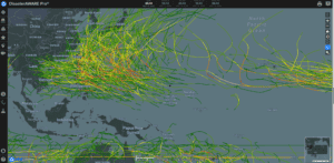
  • More intense tropical cyclones fueled by dramatically elevated sea surface temperatures
  • Anomalous storm tracks that expose communities to direct impacts from systems they rarely encounter
  • Increased frequency of extreme precipitation leading to flash floods and landslides
  • Higher storm surge potential due to warmer ocean conditions and altered atmospheric pressure patterns
  • Extended and intensified rainfall seasons that saturate soils and overwhelm drainage infrastructure

Building the decision advantage before hurricane season arrives

“During a super El Niño season, storms can intensify quickly, shift faster than normal, and produce secondary, cascading hazards like floods, landslides, and damaging storm surge. Our unique multi-hazard monitoring and risk intelligence capabilities help disaster managers keep ahead of evolving threats and fill critical knowledge and monitoring gaps,” said PDC’s Director of Applied Science, Dr. Joseph Green.

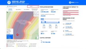
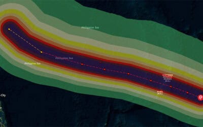
Leveraging its scientific partnerships with NOAA, NASA, and a wealth of other authoritative data sources, PDC brings together forecast information for multiple hazards into its DisasterAWARE early warning platform. To support super El Niño hurricane preparedness, the platform provides real-time early-cycle hurricane forecast track analysis, wind and precipitation forecasts, information about sea surface temperature anomalies, probabilistic storm surge, and probabilistic flood and landslide information.

“We analyze a variety of hurricane and weather data using our all-hazard impact model (AIM) to determine the level of threat a hazard may pose. We then augment the information with our proprietary AI for Humanity technology to issue alerts and generate rapid analytics on impacts to populations and infrastructure in near real time.”

“We analyze a variety of hurricane and weather data using our all-hazard impact model to determine the level of threat a hazard may pose. We then augment the information with our proprietary AI for Humanity technology.”

Event Brief tropical cyclone wind impact analytics in near real-time via DisasterAWARE

Click to zoom

NOAA tropical cyclone rainfall forecast in DisasterAWARE

Click to zoom

Critical infrastructure monitoring and exposure analysis in DisasterAWARE

Analysis of critical infrastructure exposure to storm surge in DisasterAWARE

Global flash flood hazard zones in DisasterAWARE

Click to zoom

Global landslide susceptibility data
in DisasterAWARE

Click to zoom

7 essential tools to maximize readiness now

1. Preconfigure Smart Alerts
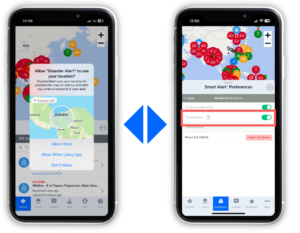
Disaster managers should set up Smart Alerts in DisasterAWARE to ensure their notifications are ready to fire the moment a tropical cyclone is detected. Once a tropical cyclone is detected, be sure to set up Smart Alerts for secondary hazards floods, landslides, and tornadoes (U.S. only).

Take our quick online tutorial for instructions on Smart Alert setup.

2. Integrate critical asset information into DisasterAWARE
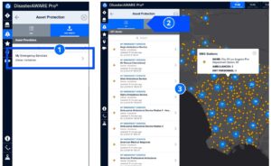
To protect the safety of assets and receive alerts about threats to essential systems that communities depend on, be sure to integrate your critical asset data using our secure protocols.

Take our in-depth online training course on critical asset and infrastructure protection.

3. Monitor tropical cyclone risks in real time
Track and monitor tropical cyclone risks in real-time, accessing the latest forecasts and observations in one location. Below are a few examples of forecast and observational data related to tropical cyclones available in the system::

  • Early-Cycle to Long-Range Hurricane Forecast Tracks and Impacts (Pacific and Atlantic): Days of lead time to position resources and begin coordination before landfall
  • 5-Day Rainfall Forecat (Global): Anticipate flooding conditions across multiple basins before they develop
    Precipitation Forecasts, Observed (Global): Track the amount of accumulated precipitation over the first 10 days of the forecast period in near real time
  • Estimated Storm Surge (Global): Projected coastal inundation zones tied to specific storm scenarios, updated as tracks evolve
  • Sea Surface Temperature Anomaly (Global): Monitor the underlying ocean conditions driving storm intensity and track shifts
  • Winds (Surface Velocity and Forecast): Determine wind direction and magnitude of wind speed
    Flood Probability Alerting (Global): NASA-PDC machine learning model combining hydrological models with satellite data, updated multiple times daily
  • Landslide Probability Alerting (Global): NASA-PDC machine learning model combining slope, soil moisture, geology, and near real-time precipitation data
  • Tornado Activity: Incudes watches and warnings, tornado probability, hail, and wind brought about by tropical cyclones.
  • Live Cameras (U.S.): Visual confirmation of evacuation routes, contraflow operations, road conditions, and coastal flooding impacts.
4. Get automated tropical cyclone analysis with Event Brief
Get automated wildfire analysis of who and what is in the path of a tropical cyclone, surfacing the highest-priority risks and predictive analytics so you can focus on action, not data gathering. Event Brief provides rapid analysis of where the tropical cyclone is, how it is progressing, and who and what is at risk, using AI to rapidly analyze to translate complex scientific data into immediate impact analytics.


5. Exercise complex tropical cyclone events with DisasterAWARE
Use DisasterAWARE to replicate complex tropical cyclone events with cascading impacts from storm surge, flooding, landslides, and other hazards during multi-jurisdictional tabletop or fully functional exercises—ensuring agencies are not building situational awareness from scratch during a crisis.

6. Assess and anticipate tropical cyclone risks before they happen
Leverage advanced models and historical tropical cyclone data to assess threats and inform planning and recovery from tropical cyclones. Below are examples of just some of the authoritative data available in DisasterAWARE to inform planning, resource pre-positioning, and recovery:

  • Historical Storm Track and Intensity Analysis: Review how past Super El Niño seasons have shaped storm behavior in your region
  • Flood Hazard Exposure Zones: Identify communities at the highest cumulative risk and prioritize mitigation accordingly
  • Landslide Exposure Zones: Identify communities at the highest cumulative landslide risk and prioritize protective measures

7. Encourage your community to download the free Disaster Alert Mobile App
Encourage your community to download PDC’s free Disaster Alert app to remain alert about wildfire threats in their locations.

PDC’s Free Disaster Alert™ Mobile App

All-hazard forecasts for the public—free

At the public level, PDC’s Disaster Alert™ mobile app extends the life-saving intelligence DisasterAWARE directly to communities worldwide. Delivering authoritative, real-time hazard alerts across all major threat types, the app empowers individuals to take protective action when it matters most—augmenting emergency services during peak response periods and strengthening overall community resilience.

[IMAGE: Disaster Alert app on smartphone showing active tropical hazard alerts]

Disaster Alert covers all major natural hazard types:
• Tropical cyclones
• Flooding
• Tsunamis and high surf
• Earthquakes
• Volcanoes
• Wildfires
• Severe storms and tornadoes
• Drought and extreme heat
• Winter storms
• Landslides
• and More…
No subscription required: Free on iOS and Android

ASEAN Coordinating Centre for Humanitarian Assistance on disaster management (AHA Centre) uses its custom version of DisasterAWARE, DMRS, to monitor and respond to Super Typhoon Yagi in 2024.
Photograph by PDC

DisasterAWARE allows you to focus on action, not data gathering

DisasterAWARE brings together information about converging weather conditions, analyzes potential impacts, and provides robust monitoring and risk analysis augmented by AI. These technologies enable decision makers to effectively deal with a variety of direct and secondary hurricane hazard impacts.

A super El Niño should trigger a shift in how agencies understand and manage tropical cyclone risk in 2026—from reactive response to proactive intelligence built before the first storm forms. As compound events continue to grow in scale and frequency, so must our tools and strategies,” said PDC’s Dr. Hughey.

In a world where multi-hazard events are growing in scale and complexity, preparedness depends on visibility, speed, and informed decision-making. With the right tools in place, agencies can move from reacting to disasters to anticipating them—and ultimately, building more resilient communities.

“A super El Niño should trigger a shift in how agencies understand and manage tropical cyclone risk in 2026—from reactive response to proactive intelligence built before the first storm forms. “

Get quarterly updates about our innovations and projects!
(Email Registration) Quarterly Email Updates
First
Last

Related News

ABOUT PDC

Pacific Disaster Center (PDC) is a leading scientific innovator of global risk reduction science and technology. As a University of Hawai’i applied science and research center, our work intersects with a variety of government, community, academic, and scientific organizations at home and around the world to build resilience to natural and man-made hazards—enhancing the capacity to quickly and accurately anticipate and prepare for new and emerging threats. Our innovations in multi-hazard early warning systems, predictive analytics, data science, and machine learning provide decision-makers with the powerful tools and insights they need to navigate today’s complex and interconnected risk landscape.

Related News