Guam, CNMI suffer impacts from second super typhoon in just 83 days

As Guam and the Commonwealth of the Northern Mariana Islands (CNMI) braced for impacts from a second super typhoon in less than three months, the Pacific Disaster Center (PDC) joined regional preparedness coordination and relief efforts...

Photograph: Pacific Disaster Center

By Chani Goering, Mary-Gardner Coppola

07/20/2026

Pictured: Saipan, Northern Mariana Islands, was impacted a second time in July 2026 by Super Typhoon Bavi after initial significant impacts from Super Typhoon Sinlaku in April. 

Photo source: BBC.com

PDC provides decision-ready risk intelligence throughout rapidly evolving Category 5-equivalent storm

As Guam and the Commonwealth of the Northern Mariana Islands (CNMI) braced for impacts from a second super typhoon in less than three months, the Pacific Disaster Center (PDC) joined regional preparedness coordination and relief efforts aimed at safeguarding communities and critical infrastructure ahead of impact. Collaborating with U.S. Pacific Command (USPACOM), U.S. Army Pacific (USARPAC), Joint Region Marianas, local emergency managers, FEMA, UNOCHA, IFRC, and others, PDC provided a common operational picture, authoritative data, and analysis through its DisasterAWARE technology ecosystem. DisasterAWARE delivered the early warning, real-time insights and analytics, and continuous situational awareness needed to support life-saving decisions before, during, and after the storm.

Super Typhoon Bavi formed on June 30 and intensified with alarming speed, reaching Category 5-equivalent strength with peak winds of 290 km/h (180 mph) as it approached the Mariana Islands. The storm’s eye crossed Rota on the morning of July 6 with sustained winds above 240 km/h (150 mph)—just 83 days after Super Typhoon Sinlaku caused widespread damage across the same islands. Communities still recovering from April’s Category 4 impacts had only days to prepare for another direct hit.

Key Response Challenges

1
A repeat strike on weakened infrastructure. Bavi arrived while power, transportation, and lifeline systems damaged by Sinlaku were still under repair. Because of PDC’s support during the April response, the Center was able to track the status of critical infrastructure already compromised as Bavi approached, enabling operators to identify areas of heightened vulnerability before landfall.
2
A rapidly evolving storm. Bavi’s rapid intensification compressed decision timelines for evacuations, sheltering, and the protection of critical infrastructure and essential services across the region.
3
A response spanning small island communities divided by ocean. Territorial governments, federal agencies, military commands, and international humanitarian organizations—spread across thousands of miles of ocean—each needed a common understanding of the same fast-moving threat as Bavi continued toward Taiwan, Japan’s Sakishima Islands, and eastern China

Insights ahead of impact

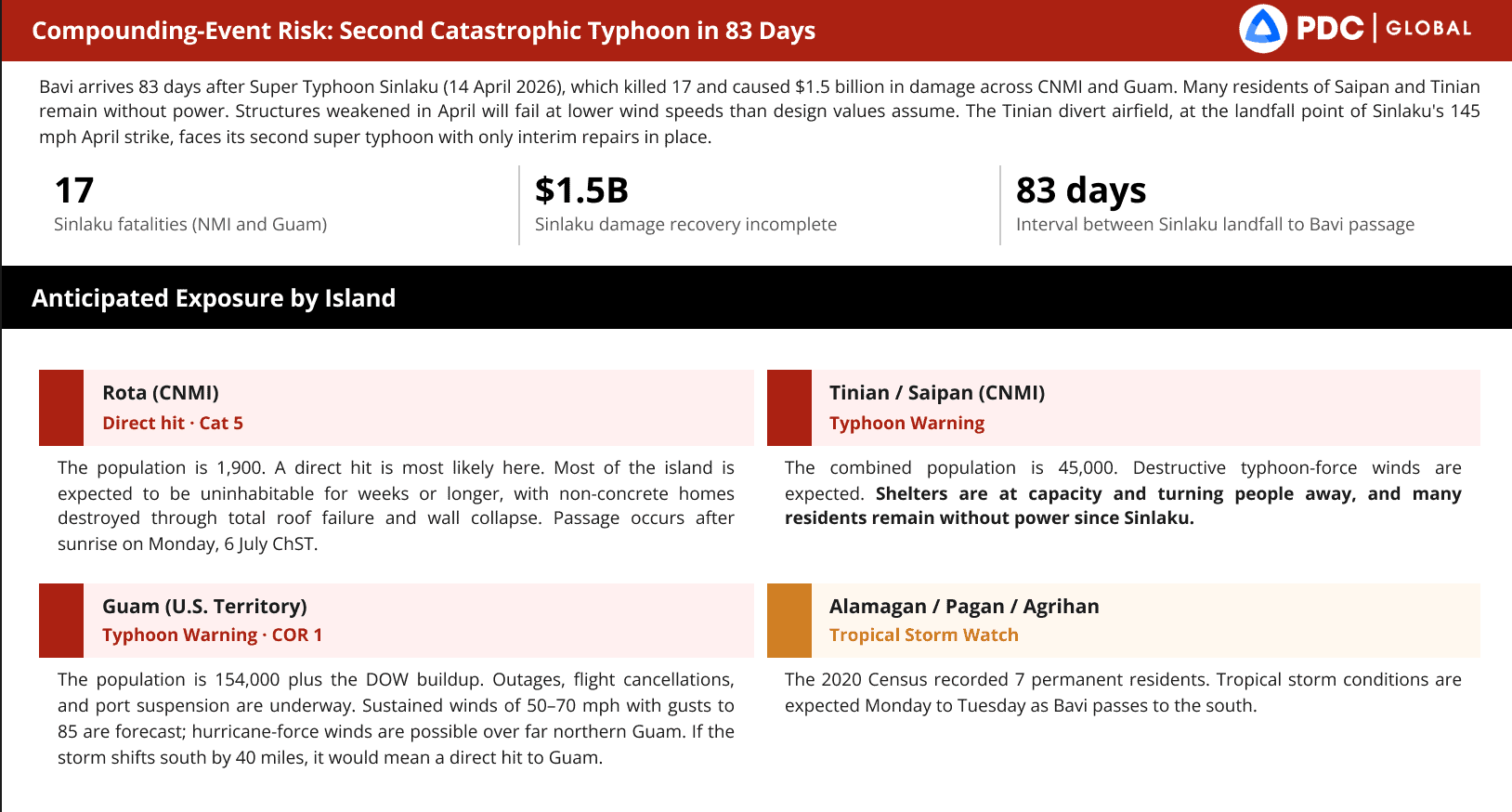
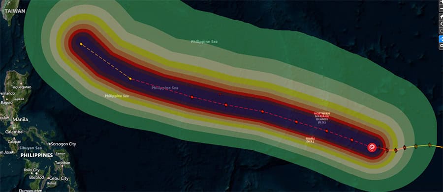
PDC assesses potential compounding super typhoon impacts from Sinlaku and Bavi, only 8 days apart.

Photograph: PDC

PDC real-time analytics supported military and civilian emergency managers as readiness conditions increased across Guam and the CNMI. Preparedness actions included the activation of emergency operations centers, issuance of public alerts and safety guidance, evacuation planning for vulnerable populations, protection of critical infrastructure, and shelter-in-place recommendations in areas expected to experience dangerous conditions. Maritime activities were suspended in several locations, while airlines adjusted operations and canceled flights to ensure passenger and crew safety.

“PDC’s early warning and anticipated impact analytics provided the lead time and insights decision makers needed to protect lives, infrastructure, and communities.”

“PDC’s early warning and anticipated impact analytics provided the lead time and insights decision makers needed to protect lives, infrastructure, and communities,” said Adam Gramann, PDC Liaison for Partner Capacity Building and Advanced Analytics.

“PDC’s pre-landfall analyses identified potential community impacts including population exposure, sheltering requirements, disruptions to critical services and lifelines, and anticipated humanitarian needs—giving planners a head start on both preparedness and response. Threats to critical infrastructure and lifeline systems were identified prior to landfall, enabling hardening to protect essential functions and reduce risk to assets,” said Gramann.

As readiness conditions rose across Guam and the CNMI, PDC’s real-time analytics gave military and civilian emergency managers a clearer picture of what lay ahead. Emergency operations centers activated. Public alerts went out. Planners moved to evacuate vulnerable populations, harden critical infrastructure, and issue shelter-in-place guidance for the areas expected to take the worst of the storm. Ports closed to maritime traffic, and airlines grounded flights to keep passengers and crews out of harm’s way.

From landfall to recovery

Following the storm’s passage, PDC delivered initial satellite-derived damage assessments, providing decision-makers with an early operational picture to support response and recovery efforts. PDC’s anticipated recovery analysis also gave planners a forward-looking assessment of post-landfall priorities, identifying anticipated requirements for infrastructure restoration, debris management, transportation access, shelter operations, logistics, and water and sanitation before they became shortfalls.

Once the storm passed by Guam and CNMI, PDC turned to recovery. Satellite-derived initial damage assessments gave decision-makers an early operational picture to guide response efforts on the ground. From there, PDC’s anticipated recovery analysis looked further ahead, prioritizing what communities would need before they needed it—requirements for restoring infrastructure, clearing debris, reopening transportation routes, standing up shelter operations, moving logistics, and restoring water and sanitation services—so planners could get ahead of shortfalls rather than react to them.

Above: PDC analytical products aid planning and response to Super Typhoon Bavi.

Photographs: PDC

Tracking Bavi across the Pacific

As Bavi continued west across the Pacific and towards Taiwan, Japan’s Sakishima Islands, and eventual landfall in eastern China on July 11, PDC stayed with it, supporting partners at each stage of the storm’s path. In Taiwan, PDC’s flash flood and landslide analysis—based on forecasted rainfall accumulations and baseline terrain—estimated that 15.2 million people,64 percent of the population, lived in moderate to very high susceptibility zones, with 8.7 million in the highest-risk areas alone. The analysis also mapped exposed infrastructure: 1,390 hospitals and clinics, 341 schools, 17 port facilities, 43 substations, 175 power plants, and more than 33,000 km of roads, giving regional partners advance understanding of where impacts could concentrate.

Before the next storm

Bavi was the second super typhoon to strike the Marianas this season—and the Pacific’s typhoon season is far from over. As communities in Guam and the CNMI rebuild once again, PDC continues to monitor the western Pacific, with the same data, analysis, and shared operational picture ready for whatever forms next.

Get quarterly updates about our innovations and projects!
(Email Registration) Quarterly Email Updates
First
Last

ABOUT PDC

Pacific Disaster Center (PDC) is a leading scientific innovator of global risk reduction science and technology. As a University of Hawai’i applied science and research center, our work intersects with a variety of government, community, academic, and scientific organizations at home and around the world to build resilience to natural and man-made hazards—enhancing the capacity to quickly and accurately anticipate and prepare for new and emerging threats. Our innovations in multi-hazard early warning systems, predictive analytics, data science, and machine learning provide decision-makers with the powerful tools and insights they need to navigate today’s complex and interconnected risk landscape.

Related News