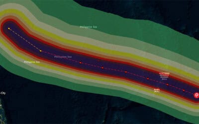
After impacting Haiti, Jamaica, the Dominican Republic, and Cuba on Tuesday, Category 3 Hurricane Matthew is re-organizing and strengthening over the warm waters of The Bahamas. According to the most recent advisory from the National Hurricane Center (NHC Advisory # 31), the Caribbean’s worst storm in nearly a decade is about 205 miles from Nassau, The Bahamas, and traveling northwest at 12 miles per hour with sustained winds of 120 miles per hour.
Matthew will continue to move northwest through the Bahamas today and into Thursday. Significant damage due to storm surge, extreme winds, and heavy rains are likely in hurricane warning areas, with the strongest winds predicted to effect the most populous island of New Providence on Thursday morning. Between 8 and 12 inches of rain are expected with up to 15 inches possible in isolated areas.
After passing through The Bahamas, Matthew is forecast to track northward very near or over the east coast of Florida, Georgia, and South Carolina toward the end of this week or over the weekend. It is difficult to predict impact areas for storms paralleling a coastline, but storm surge of at least three feet is likely for parts of Florida and Georgia.
Tropical storm force winds are also highly likely for portions of the east coast of Florida.
PDC continues to closely monitor Hurricane Matthew as it impacts The Bahamas and approaches the United States, and the Center will provide decision support and situational awareness products for the duration of the event. If you are an emergency manager or humanitarian assistance practitioner and would like access to PDC’s Emergency Operations (EMOPS) platform, click here for more information.
For more information, visit PDC’s 2016 Tropical Cyclone Matthew event page.
ABOUT PDC
Pacific Disaster Center (PDC) is a leading scientific innovator of global risk reduction science and technology. As a University of Hawai’i applied science and research center, our work intersects with a variety of government, community, academic, and scientific organizations at home and around the world to build resilience to natural and man-made hazards—enhancing the capacity to quickly and accurately anticipate and prepare for new and emerging threats. Our innovations in multi-hazard early warning systems, predictive analytics, data science, and machine learning provide decision-makers with the powerful tools and insights they need to navigate today’s complex and interconnected risk landscape.