Case Study: Unifying response under pressure during Hawai‘i’s historic flooding crisis

A rare and compounding series of storms struck the Hawaiian islands in rapid succession during the weeks of March 9-22, as two powerful “Kona low” low-pressure systems inundated the state with historic levels of rainfall and powerful winds. The dangerous and uncommon meteorological event...

By Chani Goering

04/20/2026

Pictured: Hawai‘i Emergency Management Agency leverages PDC advanced analytics and DisasterAWARE ecosystem to monitor potential dam failure and cascading hazard risks and impacts during the historic flooding event.

Photograph: Pacific Disaster Center (PDC)

A rare and compounding series of storms struck the Hawaiian islands in rapid succession during the weeks of March 9-22, as two powerful “Kona low” pressure systems inundated the state with historic levels of rainfall and damaging winds.

The dangerous and uncommon meteorological event developed into a cascading, multi-hazard crisis that unfolded simultaneously across multiple islands. Over the course of just days, the storms brought relentless rainfall that overwhelmed city and rural landscapes, triggered widespread flash flooding and landslides, and heightened concerns over dam integrity across multiple islands.

Stretching emergency response capabilities thin as conditions intensified, the need for real-time, shared situational awareness grew among decision-makers who required more than data—they needed clarity, speed, and a unified operational picture.

Pictured: residential neighborhood in Waialua, Hawaii

Photograph: Associated Press

Flooding Event Synopsis

Week of March 9–15, 2026: First Kona low develops and impacts the islands

Week of March 16–22, 2026: Second Kona low follows immediately after, compounding impacts

Back-to-back severe storm systems struck the Hawaiian islands between March 9-22, 2026, unleashing the most destructive flooding the state had seen in over two decades. This rare weather phenomenon was the result of two “Kona low” pressure systems that triggered flash floods, landslides, threats of dam failure, and widespread infrastructure damage across multiple islands.

Severity: 60+ inches of rainfall
(cumulative)

Areas impacted: 6 islands
(Kauai, O‘ahu, Maui, Hawai‘i Island, Moloka‘i)
Total Estimated Damages: $1 Billion
(preliminary estimates)

Evacuations: 5,500+
(population evacuated)

LOSSES REPORTED STATEWIDE
(as of April 06, 2026)

$832 Million

Airports: $225.9M
(10 of 14 airports damaged)

Seaports: $6.2M
(9 seaports damaged)

Highways: $129.7M
(estimated damages)

Agriculture: $23M+
(estimated economic losses)

Hospitals: 1 hosptial, 5 clinics damaged 

Hospitals: 50 of 940 schools damaged

Key Response Challenges

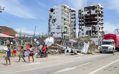
1 – Multi-Island Situational Awareness and Response Coordination: Simultaneously managing threats from flooding, landslides, and potential dam failures requires immediate access to real-time, authoritative hazard information, as well as population, infrastructure, and critical risk data to inform effective decisions. This information is often siloed across agencies.

Furthermore, achieving a unified operational picture across Hawai’i’s dispersed islands is inherently difficult without tools to support sharing of information.

2 – Access to Multi-Hazard Information and Critical Data: Storm intensity, flash flood conditions, landslide risks, and dam vulnerabilities varied significantly by island and evolved rapidly, making it challenging for county and state agencies to track the full scope of impacts in real time and allocate resources where needed most.

3 – Rapid Quantification of Impacts Pre- and Post-Landfall: Obtaining reliable estimates of impacts to population and infrastructure requires rapid synthesis of complex data in order to quickly and effectively inform response, resource prioritization, and recovery planning. Few, if any agencies have this resource while responding to a disaster.

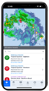
Integrating Statewide Situational Awareness

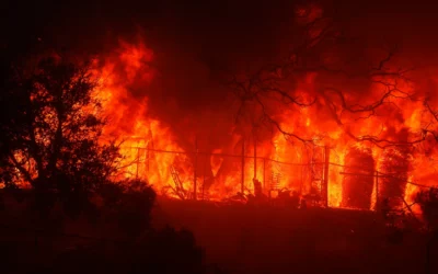
Coordinating life-saving response across the dispersed island chain demanded a level of integrated situational awareness and advanced impact analysis that only PDC could provide. The compound nature of the event—simultaneous flooding, landslides, and dam failure risk across multiple islands as well as a key weather radar outage—created an unprecedented demand for authoritative hazard information and shared situational awareness. Consolidated, scientifically vetted information was provided to decision makers through a single common operational picture, accessible to all agencies via the Center’s DisasterAWARE ecosystem. DisasterAWARE was essential for bridging critical information gaps and obtaining rapid impact estimates to help direct resources.

Real-Time Analysis Transforms Complex Data into Lifesaving Action

PDC staff were deployed across multiple operational locations—including U.S. Army Pacific (USARPAC), Theater Joint Forces Land Component Command (TJFLCC), Hawai‘i Emergency Management Agency (HIEMA), and Maui Emergency Management Agency (MEMA)—providing direct, on-site analytical support throughout the event.

New and updated data layers were rapidly integrated in real time into DisasterAWARE as the event evolved, including new radar data for Hawai’i, updated flood zone layers, and updated dam flood inundation data. By centralizing this information, decision makers at HIEMA, MEMA, USARPAC, and the Theater Joint Force Land Component Command (TJFLCC) could access the same authoritative picture without risk of acting on conflicting or outdated data from disparate sources.

Critically, the DisasterAWARE COP enabled county and state agencies across the islands to contribute and view Situation Reports (SitReps) in a shared environment—ensuring that updated impact information from Kauai, O’ahu, Maui, Hawai’i Island, and Moloka’i was visible to all decision makers simultaneously.

This shared technology was especially vital given that Hawai’i’s primary Moloka’i weather radar—serving O’ahu, Maui, Lanai, and surrounding islands—was offline for the duration of both Kona low systems. With forecasters unable to rely on this critical detection tool, the ability to share SitReps and integrate multi-source observational data through a common platform became a frontline compensating measure.

PDC’s DisasterAWARE Pro platform provides a common operational picture of damages to infrastructure as field data is received.

Photograph: PDC

Beyond data aggregation, PDC’s advanced analytical capabilities transformed hazard information into actionable intelligence—rapidly and continuously. Refined analytical products were delivered daily, including population and infrastructure exposure estimates for flood zones, and time-sensitive dam break analyses of potential downstream impacts of threatened dams such as the Wahiawa Dam on O’ahu, landslide probability maps with exposure estimates, and 100-year flood hazard exposure assessments at the community level across multiple islands.

As response operations transitioned into sustained recovery, PDC continued to support state, county, and DOW partners across Hawai’i by maintaining shared situational awareness through DisasterAWARE with official Damage Assessment and Needs Analysis (DANA) for the state.

Pre-impact integration of high-resolution rainfall
data into DisasterAWARE

Downstream dam flood potential and evacuation zones

PDC’s exclusive, real-time landslide probability
estimates

Downstream dam flood potential and evacuation zones

PDC Support Highlights

Pictured: Decision-makers statewide share situational awareness using PDC’s DisasterAWARE technology ecosystem during back-to-back storms that caused flash flooding, landslides, severe damage to highways, electrical outages, critical infrastructure damage, and more.

Photograph: PDC

40+ Advanced Analytical Products

20 EOC shifts staffed by PDC statewide

30% of PDC staff activated for response

7 DOW, State, and County response agencies supported

37+ Coordination calls supported statewide

30% Increase in DisasterAWARE usage

New / updated data in DisasterAWARE:

  • New Radar, Hawai‘i (New)
  • Building footprints Hawai‘i (New)
  • 3-Day Rainfall Accumulation Forecast (New)
  • Hawai‘i Flood Zones (Updated)
  • Hawai‘i Dams (Updated)

Public Access to Real-Time Hazard Information

100% increase

in PDC’s Disaster Alert Mobile App downloads


Real-time hazard information was also served to the public through PDC’s mobile app, which saw a 100% increase in downloads during the duration of the storms..

Major Outcomes

  • PDC’s ability to scale operations and deliver integrated, data-driven decision support across extended and complex disaster events, strengthened coordination between state and DOW partners and enabled more timely and informed response to protect communities across Hawai‘i.
  • Consolidation of hazard data into a single COP eliminated information silos across agencies and islands, allowing fast, seamless coordination of actions during a multi-hazard event that would have been far more difficult to manage through disparate information sources spread across multiple locations.

  • PDC’s rapid analytical products reduced the time needed to understand impacts, transforming data into insights about population exposure, infrastructure risk, and dam failure potential within minutes—enabling faster, more effective life-saving decisions throughout the event.

  • DisasterAWARE helped bridged several data gaps, enabling decision makers to share situational awareness in real time. By enabling shared SitReps, multi-source data integration, and continuous cross-agency situational awareness, decision makers were never operating with incomplete or conflicting information.

Get quarterly updates about our innovations and projects!
(Email Registration) Quarterly Email Updates
First
Last

ABOUT PDC

Pacific Disaster Center (PDC) is a leading scientific innovator of global risk reduction science and technology. As a University of Hawai’i applied science and research center, our work intersects with a variety of government, community, academic, and scientific organizations at home and around the world to build resilience to natural and man-made hazards—enhancing the capacity to quickly and accurately anticipate and prepare for new and emerging threats. Our innovations in multi-hazard early warning systems, predictive analytics, data science, and machine learning provide decision-makers with the powerful tools and insights they need to navigate today’s complex and interconnected risk landscape.

Related News