


Working together to strengthen disaster resilience in Lao PDR
09/02/2026
I believe that every website should be a masterpiece, combining aesthetics and functionality seamlessly.
Lao PDR initiative to reduce risk and build resilience gains momentum with Disaster Resilience Worskhop and National Disaster Preparedness Baseline Assessment mid-term review and exchange.
Project completed
0+
Satisfied clients
0+
Website launched
0+







Working together to strengthen disaster resilience in Lao PDR
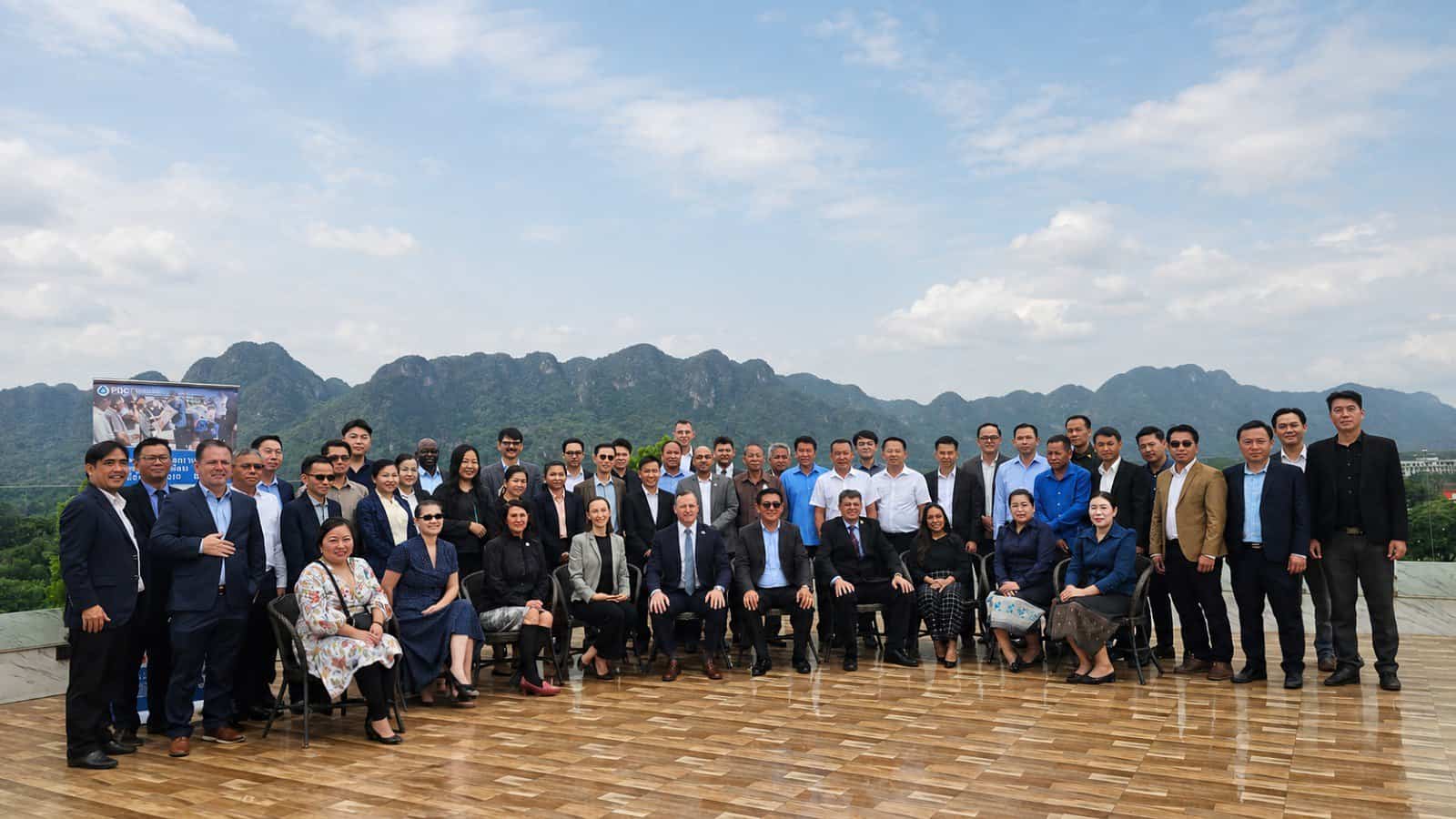
Participants validate risks and vulnerabilities across Lao PDR as part of the National Disaster Preparedness Baseline Assessment (NDPBA) and Disaster Resilience Workshop. Photograph: PDC
VANG VIENG, Lao PDR – Building resilience requires more than plans, policies, and technology. It requires people and institutions working together around a shared understanding of risk and commitment to action.
That spirit of collaboration was on display in Vang Vieng from August 18-20, where the Lao PDR Ministry of Labour and Social Welfare (MoLSW), in partnership with the Pacific Disaster Center (PDC) and the Center for Excellence in Disaster Management and Humanitarian Assistance (CFE-DM), convened government agencies, provincial authorities, humanitarian organizations, and international partners for an intensive, three-day Disaster Resilience Workshop.
Funded by CFE-DM and coordinated with the U.S. Embassy Vientiane, the event brought together representatives from Lao PDR government institutions at national, provincial and district levels, including the Ministry of Agriculture and Environment, the Lao Statistics Bureau, the Lao People's Armed Forces, alongside the Lao Red Cross, United Nations agencies, and the U.S. Department of State. Participants representing different organizations and perspectives, shared a common goal: strengthening disaster preparedness and resilience across Lao PDR.
"Through this event, we are creating a shared experience together to enhance disaster risk reduction in Lao PDR and to develop the data and information needed to build resilience."
"Lao PDR has experienced many challenges. Through this event, we are creating a shared experience together to enhance disaster risk reduction in Lao PDR and to develop the data and information needed to build resilience," said Mr. Mixay Sengchanthavong, Deputy Director General of the Social Welfare Department, Ministry of Labour and Social Welfare.
Stakeholders across Lao government sectors identify key hazard zones and help estimate population exposure during the NDPBA mid-term workshop and assessment review.Photograph by PDC
Leveraging science and local knowledge
A key focus of the workshop was ensuring that disaster risk reduction efforts in Lao PDR are informed by both science and local knowledge. Stakeholders provided input to support the National Disaster Preparedness Baseline Assessment, reviewed hazard information, identified additional data sources, and shared operational experiences from across the country. The discussions helped connect national priorities with the realities faced by communities and responders on the ground.
"The challenges we face today are increasingly interconnected. As a result, resilience depends on our ability to develop a shared understanding of risk and a shared commitment to action. This is why this event is so important," said Victoria Leat, Asia Pacific Advisor and National Disaster Preparedness Baseline Assessment Country Lead.
As disaster risks become increasingly complex and interwoven, effective resilience-building depends on strong partnerships that extend across sectors and levels of government. Throughout the workshop, participants exchanged experiences, examined disaster management challenges, and explored opportunities to strengthen coordination and preparedness efforts nationwide.
Participants also highlighted the importance of building on existing partnerships and lessons learned.
Flash flooding is just one of many hazards that present a significant threat to populations in Laos.
Photograph by PDC
"We must build on previous efforts and partnerships to help shape disaster risk reduction moving forward."
"We must build on previous efforts and partnerships to help shape disaster risk reduction moving forward," said Lloyd Puckett of CFE-DM.
Workshop participants exercise disaster management decision-making using DMRS, a custom version of PDC's DisasterAWARE technology developed for the ASEAN Coordinating Centre for Humanitarian Assistance (AHA Centre) and used operationally to support the entire ASEAN region.
Photograph by PDC
Integrating exercises and technology to improve coordination
Going deeper than discussion and knowledge exchange, the workshop included scenario-based exercises in which participants worked together to examine how institutions communicate, coordinate, and make decisions during disasters. For many attendees, the tabletop exercise provided a valuable opportunity to strengthen relationships, test assumptions, and better understand the roles and capabilities of partner organizations before a real emergency occurs.
Technology and risk information were also identified as important enablers of resilience. Following demonstrations of disaster management tools and capabilities, participants discussed how improved access to data can support preparedness planning and more informed decision-making.
"Addressing today's challenges requires versatile and dynamic tools."
"Addressing today's challenges requires versatile and dynamic tools," said U.S. Embassy Mission Disaster Relief Officer John Drollette, emphasizing the value of the capabilities provided through the partnership with PDC partnership. Additionally, participants emphasized that technology is most effective when combined with strong institutions, trusted partnerships, and a shared commitment to protecting communities.
The workshop demonstrated MoLSW's leadership in bringing together stakeholders from across government, humanitarian, and development sectors to advance a common vision for disaster resilience in Lao PDR. By creating a platform for collaboration, knowledge-sharing, and joint problem-solving, the ministry reinforced the importance of collective action in addressing the country's evolving disaster risks.
As Lao PDR continues advancing the National Disaster Preparedness Baseline Assessment, the relationships strengthened and insights generated during the workshop will help support evidence-based planning, stronger disaster management capabilities, and a more resilient future for communities across the country.
Get quarterly updates about our innovations and projects!
RIMPAC 2026: Preparing together for the Pacific’s inevitable disasters
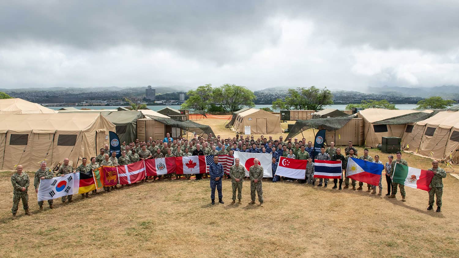
Militaries from across the Pacific join international organizations and interagency partners to engage in a three-phase HADR exercise during RIMPAC 2026.
Photograph: Commander, U.S. 3rd Fleet, RIMPAC 2026
PDC helps nations build collective disaster readiness during the HADR phase of the world’s largest international maritime exercise
Oahu, Hawai’i—Pacific Disaster Center (PDC), in partnership with the U.S. Pacific Command (US PACOM), and twenty-nine other nations, international organizations, and interagency partners, supported the humanitarian assistance and disaster response (HADR) component of Rim of the Pacific (RIMPAC) 2026—the exercise’s 30th iteration since 1971.
Held in direct proximity to the Hawaiian Islands from June 24 through July 31, RIMPAC 2026 brings together 30 nations, more than 30 surface ships, five submarines, 15 national land forces, over 206 aircraft, and more than 30,000 personnel. Within that vast undertaking, the HADR exercise trains multinational military and civilian teams to collaborate when it matters most in the region: the arrival of the next major disaster.
“Humanitarian Assistance and Disaster Response is a vital part of RIMPAC. Across our region, natural disasters are not a matter of if, but when. "
“Humanitarian Assistance and Disaster Response is a vital part of RIMPAC. Across our region, natural disasters are not a matter of if, but when. When they occur, our ability to respond quickly and effectively strengthens regional stability, reinforces our partnerships, and saves lives,” said U.S. Navy Vice Adm. Jeffrey Jablon, deputy commander, U.S. 3rd Fleet and Exercise RIMPAC 2026 Combined Task Force.
PDC played a key role across all three phases of the HADR exercise, which included planning, academics, and execution. The academic portion, which included the Senior Staff Command Forum, HADR Symposium, and HADR Staff Planners Integration Course, deepened participants’ understanding of multinational disaster response coordination, humanitarian assistance operations, and the distinct roles military and civilian organizations play during major disasters. Subject matter experts from the United Nations Office for the Coordination of Humanitarian Affairs (UNOCHA), World Food Programme (WFP), Center for Excellence in Disaster Management and Humanitarian Assistance (CFE-DM), Changi Regional HADR Coordination Centre (RHCC), and PDC shared lessons learned and operational perspectives. The Center presented its HADR mission, DisasterAWARE capabilities, and advanced analytics—highlighting how real-time impact forecasting, hazard modeling, and information sharing support life-saving decisions before, during, and after disasters.
Pictured: Japan Maritime Self-Defense Force Rear Adm. Takuo Kobayashi, Exercise Rim of the Pacific (RIMPAC) 2026 Combined Task Force vice commander provides guidance to exercise participants during the first day of the Humanitarian Assistance and Disaster Response (HADR) exercise, July 7, 2026
Photograph:Commander, U.S. 3rd Fleet, RIMPAC 2026
“Principle one is build relationships before disaster strikes. This is perhaps the most consistently validated lesson across every major HADR operation. "
PDC provides hurricane exercise daily situational awareness through its advanced analytical products and DisasterAWARE technology ecosystem.
Photograph: Commander, U.S. 3rd Fleet, RIMPAC 2026
“Principle one is build relationships before disaster strikes. This is perhaps the most consistently validated lesson across every major HADR operation. When the earthquake hits, when the tsunami arrives, it is too late to exchange business cards,” said Japan Maritime Self-Defense Force Rear Adm. Takuo Kobayashi, Exercise RIMPAC 2026 Combined Task Force vice commander.
That principle came to life in the exercise scenario: a Category 3 hurricane making direct landfall and demanding a coordinated multinational response. Participants conducted urban search and rescue, aerial assessments, healthcare emergency management, port restoration, logistics operations, and disaster coordination—the full arc of a real-world response compressed into the execution phase.
"For the 2026 RIMPAC HADR exercise, PDC supported scenario development and execution with daily situational awareness briefs, executive updates, hurricane impact forecasts, and pre-landfall impact assessments."
“For the 2026 RIMPAC HADR exercise, PDC supported scenario development and execution with daily situational awareness briefs, executive updates, hurricane impact forecasts, and pre-landfall impact assessments,” said Kalei Miller, PDC’s Senior Disaster Services Analyst and Liaison to US PACOM.
“We then shifted—just as in an actual disaster—to post-event damage assessments, needs analyses, and critical infrastructure status products built on PDC’s advanced modeling and analytics capabilities.”
Serving as White Cell support, Miller coordinated with humanitarian and military partners throughout the exercise, contributing to the master scenario event list development, request-for-assistance tracking, and overall design of the exercise.
Interoperability extended beyond the exercise floor through DisasterAWARE, providing a realistic demonstration of how partner systems can operate from a common foundation of disaster intelligence. DisasterAWARE synchronized data into Changi RHCC’s OPERA command-and-control platform, enhancing shared situational awareness and supporting data-driven coordination of assistance requests across the multinational force.
Through RIMPAC 2026, PDC reinforced the value of preparedness, information sharing, and coordinated decision-making while strengthening relationships with military and humanitarian partners throughout the Indo-Pacific region and beyond. The Center anticipates continued participation in future RIMPAC exercises and plans to integrate lessons learned from this year’s activity into its long-term training and development programs.
Get quarterly updates about our innovations and projects!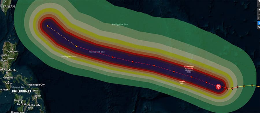
Guam, CNMI suffer impacts from second super typhoon in just 83 days
Pictured: Saipan, Northern Mariana Islands, was impacted a second time in July 2026 by Super Typhoon Bavi after initial significant impacts from Super Typhoon Sinlaku in April.
Photo source: BBC.com
PDC provides decision-ready risk intelligence throughout rapidly evolving Category 5-equivalent storm
As Guam and the Commonwealth of the Northern Mariana Islands (CNMI) braced for impacts from a second super typhoon in less than three months, the Pacific Disaster Center (PDC) joined regional preparedness coordination and relief efforts aimed at safeguarding communities and critical infrastructure ahead of impact. Collaborating with U.S. Pacific Command (USPACOM), U.S. Army Pacific (USARPAC), Joint Region Marianas, local emergency managers, FEMA, UNOCHA, IFRC, and others, PDC provided a common operational picture, authoritative data, and analysis through its DisasterAWARE technology ecosystem. DisasterAWARE delivered the early warning, real-time insights and analytics, and continuous situational awareness needed to support life-saving decisions before, during, and after the storm.
Super Typhoon Bavi formed on June 30 and intensified with alarming speed, reaching Category 5-equivalent strength with peak winds of 290 km/h (180 mph) as it approached the Mariana Islands. The storm’s eye crossed Rota on the morning of July 6 with sustained winds above 240 km/h (150 mph)—just 83 days after Super Typhoon Sinlaku caused widespread damage across the same islands. Communities still recovering from April’s Category 4 impacts had only days to prepare for another direct hit.
Key Response Challenges
1
A repeat strike on weakened infrastructure. Bavi arrived while power, transportation, and lifeline systems damaged by Sinlaku were still under repair. Because of PDC’s support during the April response, the Center was able to track the status of critical infrastructure already compromised as Bavi approached, enabling operators to identify areas of heightened vulnerability before landfall.
2
A rapidly evolving storm. Bavi’s rapid intensification compressed decision timelines for evacuations, sheltering, and the protection of critical infrastructure and essential services across the region.
3
A response spanning small island communities divided by ocean. Territorial governments, federal agencies, military commands, and international humanitarian organizations—spread across thousands of miles of ocean—each needed a common understanding of the same fast-moving threat as Bavi continued toward Taiwan, Japan’s Sakishima Islands, and eastern China
Insights ahead of impact
PDC assesses potential compounding super typhoon impacts from Sinlaku and Bavi, only 8 days apart.
Photograph: PDC
PDC real-time analytics supported military and civilian emergency managers as readiness conditions increased across Guam and the CNMI. Preparedness actions included the activation of emergency operations centers, issuance of public alerts and safety guidance, evacuation planning for vulnerable populations, protection of critical infrastructure, and shelter-in-place recommendations in areas expected to experience dangerous conditions. Maritime activities were suspended in several locations, while airlines adjusted operations and canceled flights to ensure passenger and crew safety.
"PDC’s early warning and anticipated impact analytics provided the lead time and insights decision makers needed to protect lives, infrastructure, and communities."
“PDC’s early warning and anticipated impact analytics provided the lead time and insights decision makers needed to protect lives, infrastructure, and communities,” said Adam Gramann, PDC Liaison for Partner Capacity Building and Advanced Analytics.
“PDC’s pre-landfall analyses identified potential community impacts including population exposure, sheltering requirements, disruptions to critical services and lifelines, and anticipated humanitarian needs—giving planners a head start on both preparedness and response. Threats to critical infrastructure and lifeline systems were identified prior to landfall, enabling hardening to protect essential functions and reduce risk to assets,” said Gramann.
As readiness conditions rose across Guam and the CNMI, PDC's real-time analytics gave military and civilian emergency managers a clearer picture of what lay ahead. Emergency operations centers activated. Public alerts went out. Planners moved to evacuate vulnerable populations, harden critical infrastructure, and issue shelter-in-place guidance for the areas expected to take the worst of the storm. Ports closed to maritime traffic, and airlines grounded flights to keep passengers and crews out of harm's way.
From landfall to recovery
Following the storm’s passage, PDC delivered initial satellite-derived damage assessments, providing decision-makers with an early operational picture to support response and recovery efforts. PDC’s anticipated recovery analysis also gave planners a forward-looking assessment of post-landfall priorities, identifying anticipated requirements for infrastructure restoration, debris management, transportation access, shelter operations, logistics, and water and sanitation before they became shortfalls.
Once the storm passed by Guam and CNMI, PDC turned to recovery. Satellite-derived initial damage assessments gave decision-makers an early operational picture to guide response efforts on the ground. From there, PDC's anticipated recovery analysis looked further ahead, prioritizing what communities would need before they needed it—requirements for restoring infrastructure, clearing debris, reopening transportation routes, standing up shelter operations, moving logistics, and restoring water and sanitation services—so planners could get ahead of shortfalls rather than react to them.
Above: PDC analytical products aid planning and response to Super Typhoon Bavi.
Photographs: PDC
Tracking Bavi across the Pacific
As Bavi continued west across the Pacific and towards Taiwan, Japan’s Sakishima Islands, and eventual landfall in eastern China on July 11, PDC stayed with it, supporting partners at each stage of the storm’s path. In Taiwan, PDC’s flash flood and landslide analysis—based on forecasted rainfall accumulations and baseline terrain—estimated that 15.2 million people,64 percent of the population, lived in moderate to very high susceptibility zones, with 8.7 million in the highest-risk areas alone. The analysis also mapped exposed infrastructure: 1,390 hospitals and clinics, 341 schools, 17 port facilities, 43 substations, 175 power plants, and more than 33,000 km of roads, giving regional partners advance understanding of where impacts could concentrate.
Before the next storm
Bavi was the second super typhoon to strike the Marianas this season—and the Pacific’s typhoon season is far from over. As communities in Guam and the CNMI rebuild once again, PDC continues to monitor the western Pacific, with the same data, analysis, and shared operational picture ready for whatever forms next.
Get quarterly updates about our innovations and projects!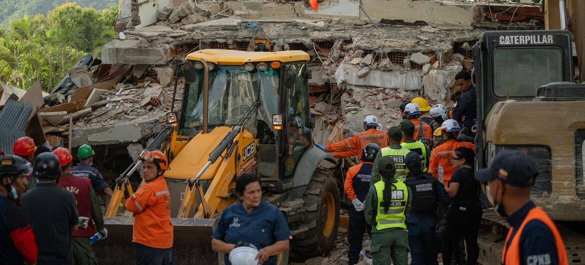
Saving lives during Venezuela’s twin earthquake catastrophe
Tens of thousands of buildings, along with critical infrastructure, were damaged or destroyed due to widespread soft-story construction prone to pancake collapse.
Photograph: Associated Press
How interoperability and rapid analysis helped save lives
On June 24, 2026, two mega quakes (M7.2 and M7.5) struck west of the capital city of Caracas, Venezuela, roughly 39 seconds apart, devastating La Guaira and the states of Yaracuy and Carabobo. The sequence generated hundreds of aftershocks and triggered the largest international urban search and rescue (USAR) mobilization in the region’s history. PDC’s initial estimates placed 13.5 million people within the shaking zone, including a vulnerable population of 4.46 million.
Joining one of the largest-scale relief efforts in history, PDC embedded analysts and its DisasterAWARE technology ecosystem into mission operations engaged in the response. From rapid impact assessments and USAR activity tracking, to 96-hour needs forecasting and real-time integration of building damage data, PDC was the authoritative data provider that guided major U.S. relief operations. Shortly after impact, its information streams and analytical insights generated initial estimates of impacts to critical systems to aid planning and prioritization of resources for responders facing widespread building collapse and disrupted power, water, and communications lifelines.
DisasterAWARE: A backbone of authoritative data for the global response
The response began within minutes. Six minutes after the earthquakes, DisasterAWARE had issued early warnings for the quakes and tsunami hazard, along with estimated impacts and needs. By eleven minutes, PDC Smart Alerts had reached more than 3.5 million DisasterAWARE users worldwide. And within 30 minutes, direct operational support to responders had been activated, with continuous updates flowing thereafter.
Timeline of PDC's early onset insights and expert analysis
6 min
DisasterAWARE issues early warning (EQs/tsunami), estimated impacts, needs
11 min
PDC Smart Alerts go to 3.5M+ DisasterAWARE users worldwide
<30 min
Joint Operations Center (JOC) activation, with continuous updates
A PDC Event Brief was generated within minutes, providing the earliest understanding of impacts to populations, infrastructure, and critical community lifelines such as power, communication, and transportation. PDC estimates 13.5 million people were inside the shaking zone, many of whom live in informal hillside settlements prone to destruction from quakes and rain-triggered landslides.
Photograph: PDC
Venezuela Twin Earthquake Event Synopsis
Event Stats
(As of July 7, 2026)MagnitudesM7.2 + M7.5
Aftershocks400+
Death toll3,342
Injured16,740
Displaced12,841 registered
Missing40,000+
DamagesUS$37B
USAR67 teams / 2,500+ pers
Source: Pacific Disaster Center (PDC), Government of Venezuela, UNOCHA sitreps, others. Counts expected to rise.
Pictured: Early damage assessment information derived from satellite data in DisasterAWARE.
Key Response Challenges
1
Scale of destruction. Tens of thousands of buildings along with critical infrastructure were damaged or destroyed due to widespread soft-story construction prone to pancake collapse. PDC estimates 13.5 million people were inside the shaking zone, many of whom live in informal hillside settlements prone to destruction from quakes and rain-triggered landslides.
2
A massive, multinational coordinated response. Sixty-seven USAR teams—more than 2,500 personnel and 188 dogs from dozens of nations—converged alongside U.N. agencies, nongovernmental organizations (NGOs), and military elements, each arriving with different systems, data, and reporting chains.
3
Search and rescue access and logistics. Infrastructure damage across seven states, including the partial collapse of a key airport and landslides along the coastal corridor, complicated logistics in the critical first 72 hours. USAR teams had to convoy in from hundreds of miles away over damaged roads and severed bridges.
The 72-hour race to reach survivors
PDC briefs on USAR locations and team activities.
Photograph: PDC
While lives hung in the balance, partners from every sector of the response relied on the same live foundation of PDC data through the DisasterAWARE ecosystem. PDC analysts collaborated with civil and military partners responding to the crisis from within the Combined Humanitarian Coordination Cell to provide early estimates of impacts to affected populations, the built environment, airports, seaports, hospitals, and schools, as well as tsunami and sea-level fluctuation warnings. Its critical infrastructure exposure assessments helped rank the hardest-hit areas while ground reports were still hours away. These insights informed operational briefings, planning cells, and resource decisions.
With sixty-seven USAR teams from dozens of nations, coordination challenges could not be solved through individual field reports alone. PDC’s live tracking of team locations, capabilities, and sector assignments gave a holistic view of which sectors had teams working, which did not, and where arriving units could do the most good alongside regional and international partners already on the ground. PDC also helped provide a comprehensive civil-military operating picture, integrating information from UNOCHA, WFP, IFRC, PAHO, and others for continuous situational awareness.
Above: Sample analytical products developed by PDC to aid international response and recovery efforts.
Photographs: PDC
The same picture shaped how assistance was physically moved. PDC assessments of airports, seaports, and road corridors identified which access points could bear the load, letting logistics staff set routes and priorities for USAR teams and relief cargo entering the affected region. More than 37 mission-critical datasets—shaking intensity, satellite-derived damage, infrastructure status, aid distribution sites, and more—were added to DisasterAWARE during the response, keeping the picture current as conditions changed.
As rescue gave way to recovery, PDC’s 96-hour needs outlooks, powered by the Center’s AI for Humanity technology, gave each planning cycle a head start—flagging emerging demands across health system restoration, debris management, transitional sheltering, water and sanitation, and humanitarian coordination before they became shortfalls.
The mission is not finished. PDC platforms remain the operational backbone for tracking evolving impacts, coordinating relief, and supporting evidence-based decisions as Venezuela’s recovery continues.
One mission. Many partners. Safer world.
PDC capabilities informed the J79 Civil-Military Operations Division and the international humanitarian relief effort, enabling information sharing and quick integration of new data from multiple sources. During the response, 352 new DisasterAWARE user accounts were created—153 U.S. Government accounts and 199 accounts for humanitarian actors. Organizations PDC supported, included:
- U.S. Government (SOUTHCOM, U.S. State Department)
- United Nations Office for the Coordination of Humanitarian Affairs (UNOCHA)
- World Food Programme (WFP)
- Pan American Health Organization (PAHO/WHO)
- International Federation of Red Cross and Red Crescent Societies (IFRC)
- Others
Why preparedness makes a difference
One of the biggest challenges in responding to a disaster of this scale is information-sharing across organizational lines. As a neutral, science-based organization trusted globally across agencies and sectors, PDC has worked hard to close this gap by providing a common operational picture during times of disaster that strengthens collaboration, coordination, and outcomes. The DisasterAWARE ecosystem was not introduced in the middle of a crisis—it was already part of the international operating environment that bridges communities. It has been exercised through continuous engagements and is embedded in the workflows of the organizations that need it.
This type of long-term investment meant that when the massive earthquake doublet rocked Venezuela, there was no ramp-up period. Impact assessments reached decision-makers within hours, and 338 new users across the response community were onboarded onto platforms their organizations already trusted.
The mission is not finished. PDC platforms remain the operational backbone for tracking evolving impacts, coordinating relief, and supporting evidence-based decisions as Venezuela’s recovery continues
Major Outcomes
Throughout crisis operations, PDC provided authoritative data, rapid analytics, and forward-looking decision support that enabled senior leaders, planners, logisticians, interagency partners, and multinational responders to operate from a more integrated common operational picture.
✓
Rapid impact assessment: Complete integration of the Philippine Institute of Volcanology and Seismology (PHIVOLCS) data into PhilAWARE provided immediate early warning and visualization of impacts for decision-makers in the Philippines.
✓
System interoperability: The DisasterAWARE ecosystem bridged partner systems, ensuring a common foundation of operational data for senior-level decision-making..
✓
A shared operational picture for USAR: Team locations, capabilities, sector assignments, and deployment status for 67 international teams supported coverage analysis and gap identification.
✓
Logistics planning: Assessments of airports, seaports, and critical infrastructure informed route evaluation, access prioritization, and the flow of USAR teams and humanitarian assistance into theater.
✓
Anticipated operational needs: AI-powered 96-hour forward assessments guided decisions across health, debris, sheltering, WASH, logistics, and humanitarian coordination through the recovery transition.
✓
Information sharing: Humanitarian partners and the J79 Civil-Military Operations Division leveraged PDC platforms to integrate information that could be shared across mission operations.
From assessment to action: Lao PDR launches national risk reduction initiative
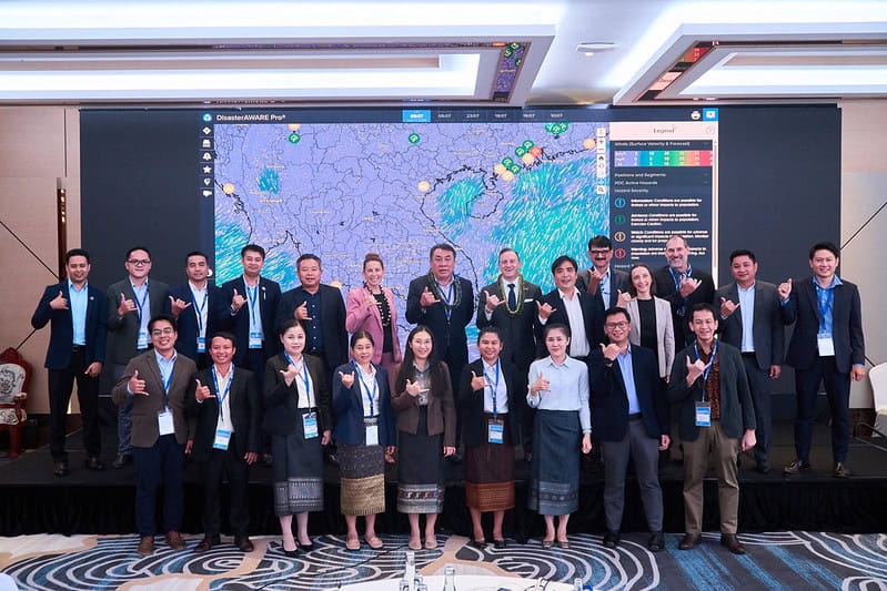
In partnership with Pacific Disaster Center (PDC), the Government of Lao PDR kicked off a new disaster risk reduction initiative, bringing together multiple stakeholders to participate in a National Disaster Preparedness Baseline Assessment. Participants included the National Disaster Management Office of Lao PDR under the Ministry of Labour and Social Welfare, Lao Statistic Bureau, Lao Police, Department of Meteorology and Hydrology, Ministry of Defense, Ministry of Foreign Affairs, Ministry of Health, Lao Red Cross, the ASEAN Coordinating Centre for Humanitarian Assistance on disaster management (AHA Centre), World Food Programme, United Nations Office for Disaster Risk Reduction, and UN Development Programme.
Photograph: PDCVientiane, Lao PDR — On June 17, 2026, Lao PDR solidified its commitment to building disaster resilience, joining 33 countries worldwide to partner with the Pacific Disaster Center (PDC) on a National Disaster Preparedness Baseline Assessment (NDPBA). More than an assessment, the program will equip Lao PDR with PDC’s advanced technology ecosystem and analytical capabilities to put assessment data into action to save lives and inform decision-making.
Carried out in partnership with Lao’s National Disaster Management Office (NDMO), under the Ministry of Labour and Social Welfare (MoLSW), the initiative was kicked off during a workshop in the capital city of Vientiane, convening representatives from across government ministries, United Nations agencies, and the broader humanitarian sector.
In 2024, Nu Village in Lao's Cai Province was struck by a landslide triggered by flash flooding, burying 37 homes.
Photograph by VNExpress.net
A challenging risk landscape
Lao PDR’s risk profile involves seasonal flooding which inundates vulnerable communities along the Mekong River and its tributaries, tropical storms that can trigger deadly landslides across the mountainous north, and millions of hectares of land that remain affected by unexploded ordnance (UXO)—a man-made hazard stemming from a legacy of past conflicts that continues to claim lives and constrain land use today.
Against this backdrop, the government of Lao PDR is confronting these challenges through the scientific advancements of PDC and shared commitments of partners across sectors to protect the nation’s most vulnerable communities.
Lao soldiers aid in the rescue of buried villagers following a massive landslie in Nu Village, Cai Province in Lao in 2024.
Photograph by VNExpress.net
"This is a meaningful workshop to initiate an important activity in Lao to help reduce disaster risk and the threat to livelihoods. We are looking forward to this project which will help us build disaster resilience at the central, provincial, and local levels."
“This is a meaningful workshop to initiate an important activity in Lao to help reduce disaster risk and the threat to livelihoods. We are looking forward to this project, which will help us build disaster resilience at the central, provincial, and local levels," said Kindavong LUANGRATH, Deputy Director General, Social Welfare Department, MoLSW.
Risk awareness at every level
PDC’s approach to the national baseline assessment goes well beyond a broad-stroke national risk inventory; it assesses risk at a more granular level and delivers subnational, locally grounded insights that decision-makers need to effectively plan for and respond to disaster risks. The year-long project engages multiple stakeholders who hold important pieces of the disaster risk reduction puzzle, which, when brought together, offer a comprehensive picture of risk and vulnerability across Lao PDR.
"Every disaster is ultimately local, its true impacts determined not by national averages, but by what exists on the ground in each community. Understanding risk in Lao PDR means understanding the distinct vulnerabilities of each community."
“Every disaster is ultimately local, its true impacts determined not by national averages, but by what exists on the ground in each community. Understanding risk in Lao PDR means understanding the distinct vulnerabilities of each community. The NDPBA program gives leaders at every level the subnational intelligence they need to act on those distinctions—with speed, confidence, and the full weight of verified data behind every decision,” said Dr. Erin Hughey, Deputy Executive Director, Pacific Disaster Center.
Turning data into action from day one
The assessment also provides a comprehensive analysis of national disaster management capacities, identifying gaps and limitations and providing tools to help prioritize investments across the nation.
“A defining aspect of this program is that it does not ask countries to wait for a final assessment before seeing results. From the outset, assessment findings are integrated into PDC’s DisasterAWARE technology ecosystem to give nations an almost immediate picture of their real-world disaster risk profiles, the ability to share and exchange information, and the ability to understand vulnerabilities,” said Victoria Leat, Asia Pacific Advisor and Lao NDPBA Country Lead.
Through DisasterAWARE, decision-makers can monitor active hazards, rapidly assess potential impacts to vulnerable populations, critical infrastructure, and community lifelines to determine what actions are needed and which agencies to mobilize. DisasterAWARE grounds these capabilities in local data from day one.
A coalition for resilience
The timing of Lao PDR’s initiative is especially significant. A robust coalition of United Nations partners—including the World Food Programme (WFP), the United Nations Office for Disaster Risk Reduction (UNDRR), and the United Nations Development Programme (UNDP)—is already active in the country, and the assessment arrives at a moment when stakeholders are actively seeking to consolidate efforts, align data systems, and work more efficiently amid constrained resources.
Photographs by PDC
The AHA Centre demonstrates DisasterAWARE capabilities that its Emergency Operations Center leverages through the use of DMRS, one of several customized solutions that make up PDC's DisasterAWARE ecosystem.
Photograph by PDC
"..it takes only two AHA Centre staff to cover all of the disaster monitoring and analysis responsibilities of the ASEAN region."
The NDPBA’s multi-stakeholder framework is designed precisely for this collective approach, unifying efforts through DisasterAWARE so all organizations, including Lao PDR’s key national stakeholders, can formulate informed decisions and operate from a common picture of risk and a foundation of validated data. National stakeholders who are integrated into the project include Lao’s Ministry of Defense, the Ministry of Foreign Affairs, Ministry of Health, Department of Meteorology and Hydrology, Lao Statistics Bureau, Lao Red Cross, Lao Police, and the ASEAN Coordinating Centre for Humanitarian Assistance on Disaster Management (AHA Centre), among others, to pool knowledge and collectively build a more complete picture of national risk.
“As a result of DMRS , it takes only two AHA Centre staff to cover all of the disaster monitoring and analysis responsibilities of the ASEAN region. We are pleased to see this same capability being brought to Lao through this project,” said the AHA Centre during the NDPBA kick-off workshop. The AHA Centre’s DMRS is one of several versions of customized solutions offered by PDC through its DisasterAWARE ecosystem.
Support from other stakeholders was expressed during the workshop as well.
Photograph: Pacific Disaster Center (PDC)
"This project represents the United States’ continued commitment to supporting disaster risk reduction in Lao PDR."
—U.S. Embassy Mission Disaster Relief Officer John Drollette
“We pledge strong support for this program and will do our best to collaborate for this project to be a success.”
— Lao Statistics Bureau representative
An investment that endures
Beyond the deliverables, the program will produce a five-year plan of action and cultivate a culture of data literacy and institutional confidence in evidence-based decision-making that endures long after the final findings are delivered.
When a disaster strikes and critical decisions must be made under pressure, this embedded capacity is what makes the difference. Among the 33 countries that have completed PDC’s program, one consistent outcome is evident: when communities have granular, locally verified risk data integrated into real-time decision tools, they act faster, target resources more precisely, and save more lives.
Get quarterly updates about our innovations and projects!
Hero

About

Services

Projects

Pricing

