

Current Snapshot
For all the latest updates visit: DisasterAWARE
1800x1080ec
3
closer
061450_earliest_reasonable_toa_34
061447_earliest_reasonable_toa_34
061448_earliest_reasonable_toa_34
061448_peak_surge
061448WPCQPF_sm
wp2226
22W_061200sair
By PDC’s Senior Weather
Specialist Glenn James

The Pacific Disaster Center’s (PDC Global) Sunday, September 6, 2026, Tropical Cyclone Activity Report…for the Pacific Ocean, the Indian Ocean, and adjacent Seas.
Tropical Cyclones
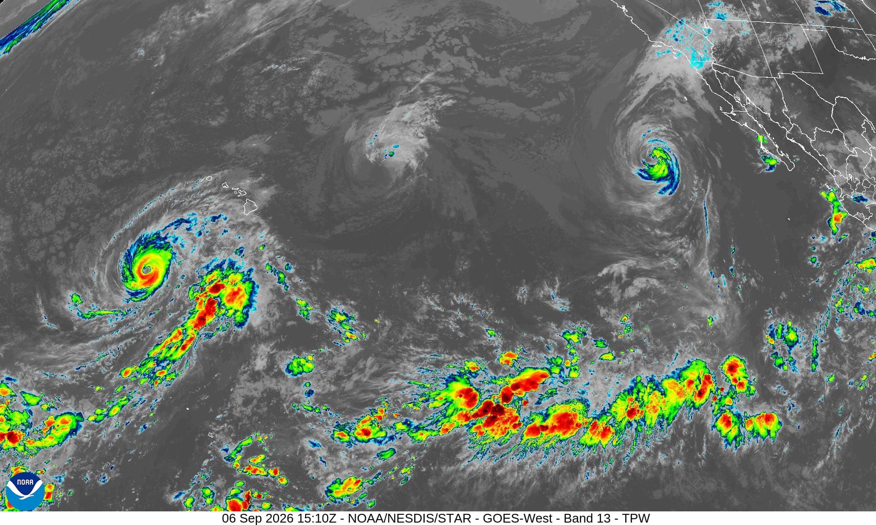
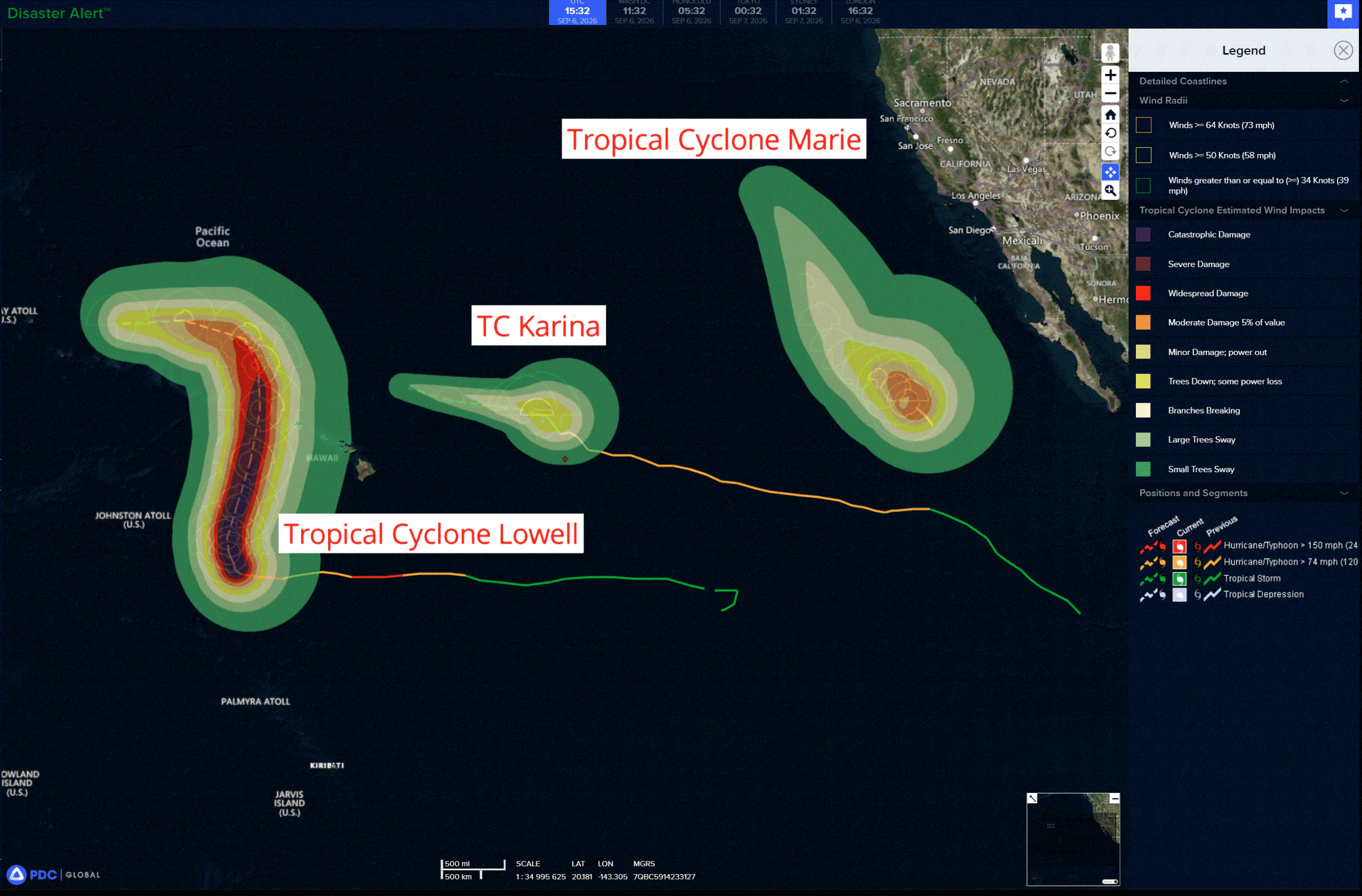
Tropical Cyclone 11E (Karina) is located about 680 miles east-northeast of Hilo, Hawaii
Tropical Cyclone 13E (Marie) is located about 800 miles west of of the southern tip of Baja California
Tropical Cyclone 12E (Lowell) is located about 580 miles south-southwest of Lihue, Hawaii
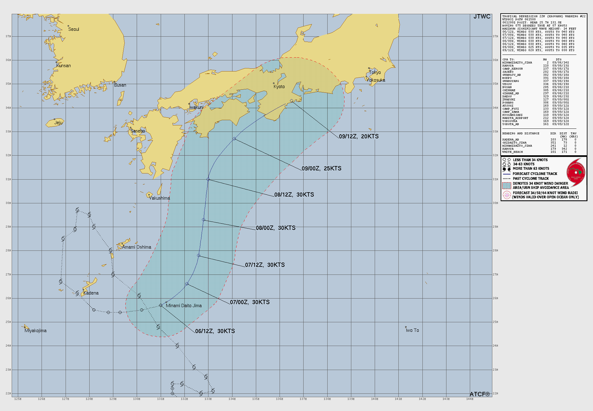
Tropical Cyclone 22W (Krovanh) is located approximately 179 miles east-southeast of Kadena AB
Northeast Pacific:
Tropical Cyclone 13E (Marie)
MARIE TO CONTINUE PRODUCING DANGEROUS BEACH CONDITIONS ALONG THE COAST OF BAJA CALIFORNIA AND SOUTHERN CALIFORNIA FOR ANOTHER COUPLE DAYS
According to the NHC advisory number 22…
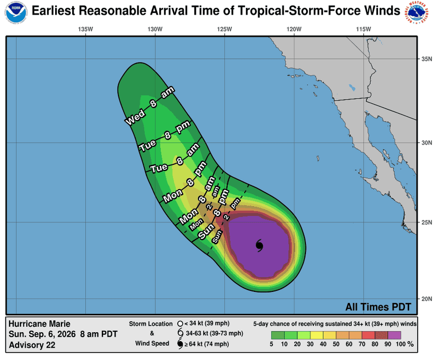
Marie is moving toward the northwest near 9 mph (15 km/h). A turn toward the west- northwest is forecast tonight. Marie is then expected to resume a northwestward heading at a faster forward speed by Tuesday. Maximum sustained winds have decreased to near 80 mph (130 km/h) with higher gusts. Steady weakening is expected to continue for the next several days. Marie is forecast to become a post-tropical remnant low on Wednesday. Hurricane-force winds extend outward up to 50 miles (85 km) from the center and tropical-storm-force winds extend outward up to 185 miles (295 km). The estimated minimum central pressure is 977 mb (28.85 inches).
HAZARDS AFFECTING LAND
SURF: Swells generated by Marie will continue to affect portions of the coast of southwest Mexico, the Baja California Peninsula, and Southern California for the next few days. These swells are likely to cause life-threatening surf and rip current conditions.
Central North Pacific:
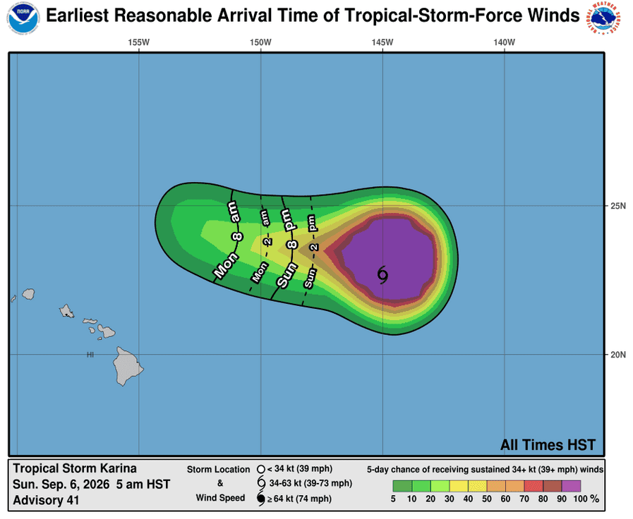
Tropical Cyclone 11E (Karina)
KARINA EXPECTED TO BECOME A POST-TROPICAL GALE TONIGHT
According to the NHC advisory number 41…
Karina is moving toward the northwest near 7 mph (11 km/h). A turn toward the west-northwest is expected today, along with an increase in forward speed. Maximum sustained winds remain near 60 mph (95 km/h) with higher gusts. Weakening is expected, and Karina is forecast to become a post-tropical gale by late tonight. Tropical-storm-force winds extend outward up to 185 miles (295 km) from the center. The estimated minimum central pressure is 992 mb (29.30 inches).
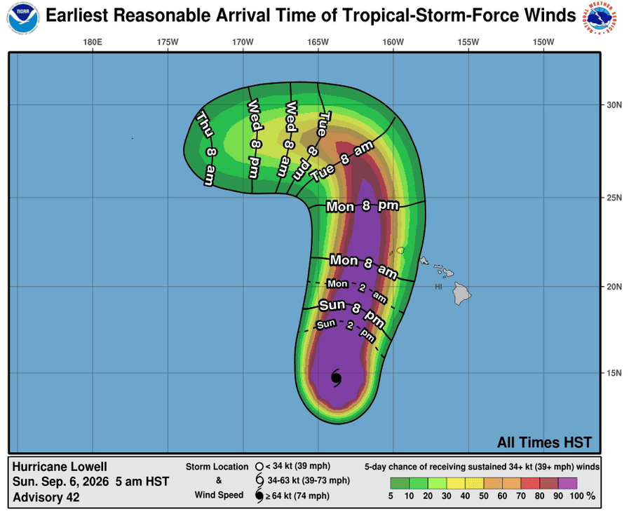
Tropical Cyclone 12E (Lowell)
TROPICAL STORM WARNING ISSUED FOR KAUAI AND NIIHAU
According to the NHC advisory number 42…
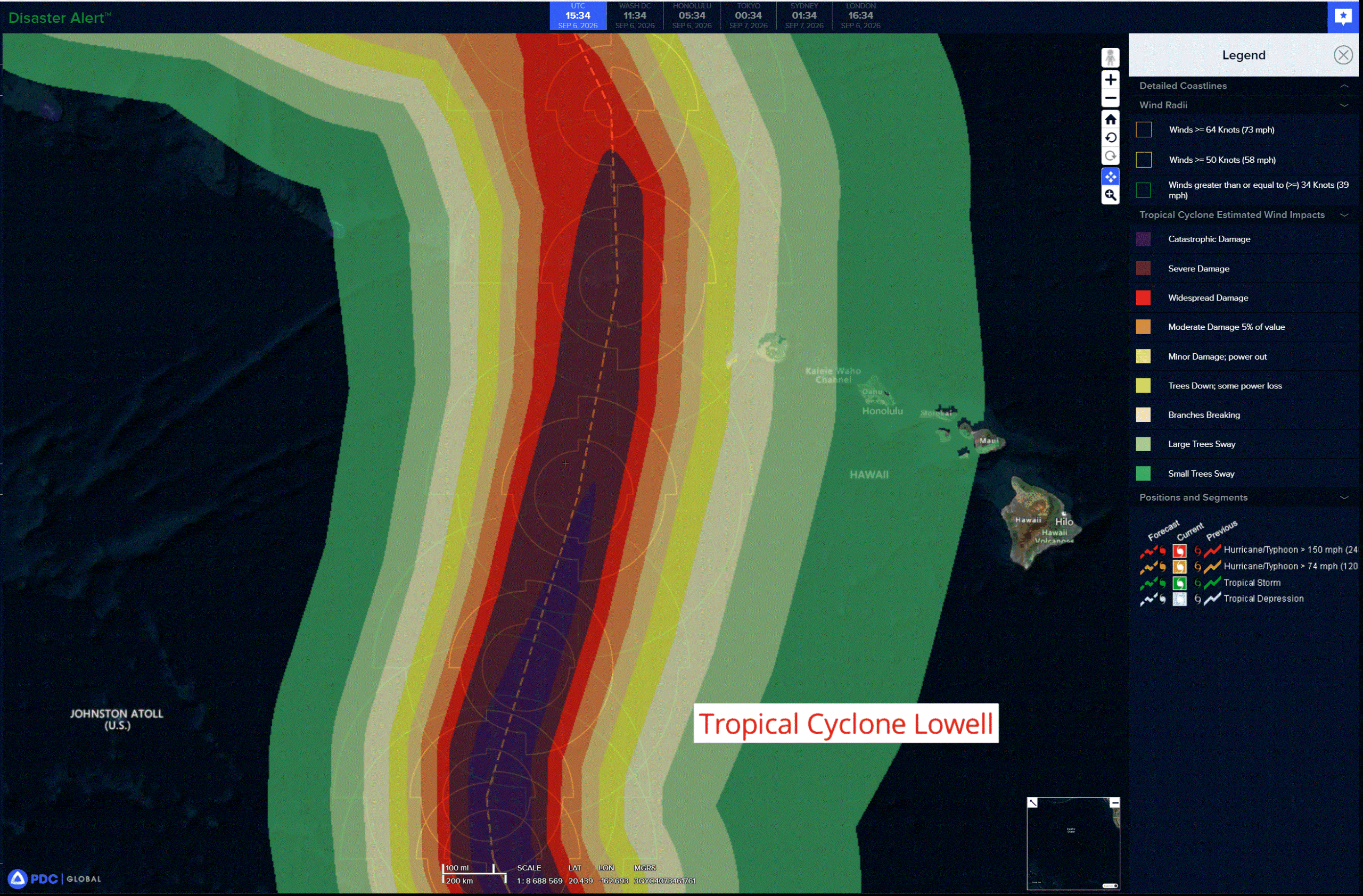
Lowell is moving toward the north-northwest near 6 mph (9 km/h). A turn toward the north and north-northeast with an increase in forward speed is expected over the next couple of days, bringing the center of Lowell across portions of the Papahanaumokuakea Marine National Monument, just west of the main Hawaiian Islands, Monday night. Lowell is forecast to turn toward the north-northwest and slow down by Tuesday night after passing the Hawaiian Islands. Maximum sustained winds are near 125 mph (205 km/h) with higher gusts. Lowell is a category 3 hurricane on the Saffir-Simpson Hurricane Wind Scale. Some fluctuations in intensity remain possible through this afternoon, followed by gradual weakening beginning tonight. Lowell is expected to remain a major hurricane through Monday. Hurricane-force winds extend outward up to 50 miles (85 km) from the center and tropical-storm-force winds extend outward up to 175 miles (280 km). The estimated minimum central pressure is 943 mb (27.85 inches).
HAZARDS AFFECTING LAND
WIND: Tropical storm conditions are expected in Kauai County by Monday afternoon or evening. Hurricane conditions are possible in in the Papahanaumokuakea Marine National Monument between Nihoa and French Frigate Shoals Monday night, with tropical storm conditions beginning Monday afternoon. Wind speeds atop and on the windward and leeward sides of hills and mountains are often up to 30 percent stronger than the near-surface winds, and in some elevated locations could be even greater.
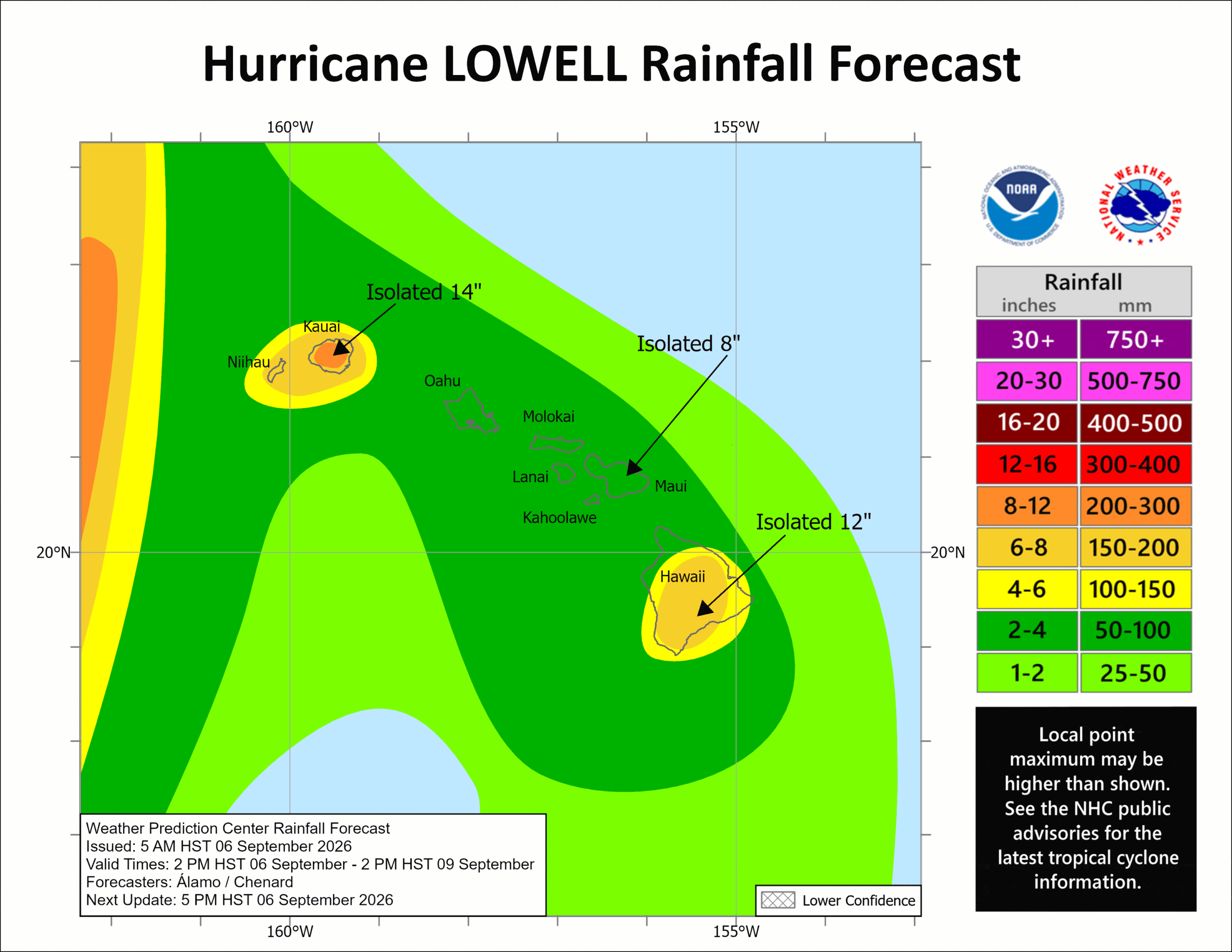
RAINFALL: Hurricane Lowell is expected to produce rainfall totals of 6 to 10 inches for Kauai, with maximum totals of 14 inches possible. For the Big Island, 4 to 8 inches of rain is expected with isolated totals of 12 inches possible. For Maui, 2 to 4 inches of rain is expected, with isolated maximum totals of 8 inches possible. Across the remaining islands, rainfall of 2 to 4 inches is possible. This rainfall may produce significant flash flooding and mudslides, especially across Kauai County and portions of the Big Island.
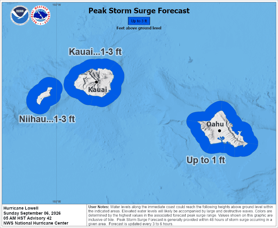
STORM SURGE: The combination of storm surge and tide will cause normally dry areas near the coast to be flooded by rising waters moving inland from the shoreline. The water could reach the following heights above ground somewhere in the indicated areas if the peak surge occurs at the time of high tide…
Kauai County…1-3 ft
Oahu…Up to 1 ft
The deepest water will occur along the immediate coast near and to the right of the center, where the surge will be accompanied by large and destructive waves. Surge-related flooding depends on the relative timing of the surge and the tidal cycle, and can vary greatly over short distances.
SURF: Swells from Lowell are likely to cause life-threatening surf and rip current conditions during the next several days across many of the Hawaiian islands.
Western Pacific, Indian Ocean, and adjacent Seas:
Western Pacific
Tropical Cyclone 22W (Krovanh)
According to the JTWC warning number 22…sustained winds were 30 knots with gusts to 40 knots
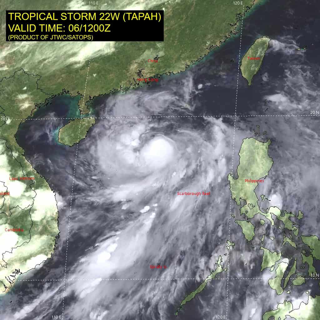
Animated enhanced infrared (eir) satellite imagery depicts tropical depression 22W (Krovanh) with a fully exposed low-level circulation center (llcc) and flaring convection confined to the southwestern quadrant. 22W has stalled in place since 061000z, just southwest of Minami Daito Jima. Pressure readings from surface observations on the island have dropped to 990 mb as the circulation inches closer.
Environmental analysis indicates that 22W remains in a marginal environment characterized by moderate poleward outflow aloft, 15-20 kts southeasterly vertical wind shear, dry air entrainment, and warm (28-29 c) sea surface temperatures.
TD 22W is forecast to begin turning northeastward within the next 6 hours as the primary steering mechanism transitions to the subtropical ridge centered to the southeast of Japan. 22W will then track generally northward, along the western periphery of the
ridge through 48 hours. Following 48 hours, the trajectory is expected to become more northeastward with an increasing speed of advance as the system tracks along the northwestern extent of the ridge. 22W is forecast to skirt the southern coast of Japan after 60 hours with the remnant vortex passing south of Kyoto, around 72 hours.
In terms of intensity, 22W is forecast to maintain its current intensity of 30 kts through 48 hours under the effects of the marginal environment. While dry air entrainment is expected to worsen, poleward outflow will improve due to the system tapping into a jet streak extending over northern Honshu. After 48 hours, southeasterly shear will greatly increase, causing 22W to weaken as it approaches southern Japan. Dissipation is forecast to occur at around 72 hours, as the shallow vortex accelerates northeastward and interacts with the mountainous terrain of the Shikoku and Kansai regions.