
")
Current Snapshot
For all the latest updates visit: DisasterAWARE
GOES18-TPW-13-900×540
maila
30P_060600sair
himawari9_ir_30P_202604061430_lat-9.7-lon155.5
30P_tracks_latest
v
31P_061200sair
himawari9_ir_31P_202604061430_lat-16.5-lon173.8
31P_tracks_latest
By PDC’s Senior Weather
Specialist Glenn James

The Pacific Disaster Center’s (PDC Global) Monday, April 6, 2026, Tropical Cyclone Activity Report…for the Pacific Ocean, the Indian Ocean, and adjacent Seas
Current Tropical Cyclones:
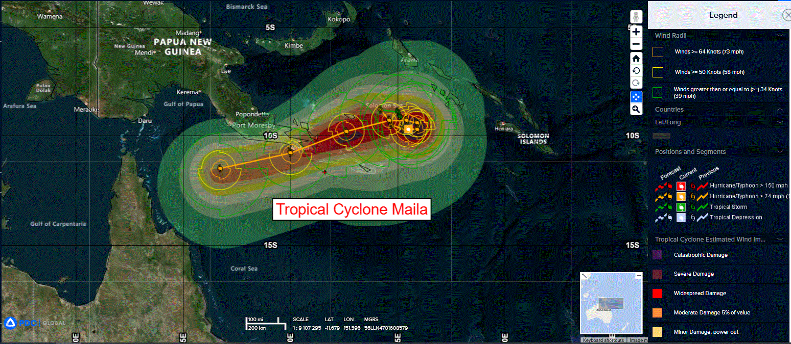
Tropical Cyclone 30P (Maila)…is located approximately 667 NM south of Kapingamarangi
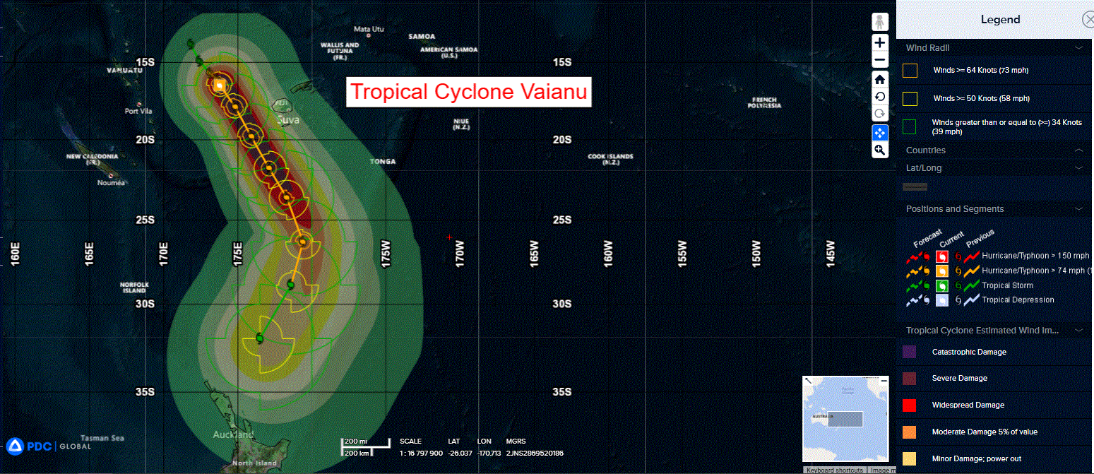
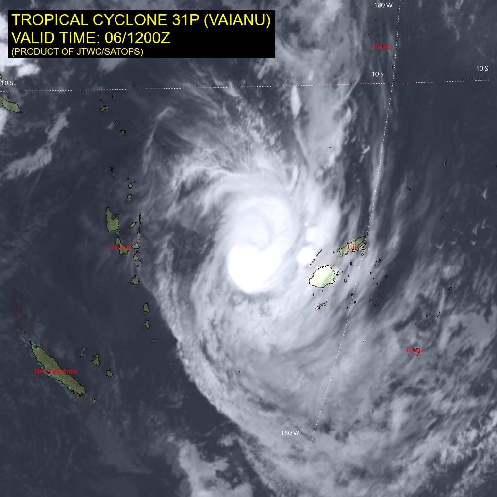
Tropical Cyclone 31P (Vaianu)…is located approximately 205 NM west of Suva, Fiji
Northeast Pacific Ocean: There are no Tropical Cyclones
The last regularly scheduled Tropical Cyclone Activity Report of the 2025 eastern North Pacific Hurricane Season has been issued. Routine issuance of this section of the PDC product will resume on May 15, 2026. During the off-season, Special Tropical Weather Outlooks will be issued as conditions warrant by the NHC.
Central Pacific Ocean: There are no Tropical Cyclones
The 2025 central North Pacific hurricane season has ended. As such, the final routine Tropical Cyclone Activity Report for the 2025 season has been issued. Routine issuance of this section of the PDC product will resume on June 1, 2026. During the off-season, Special Tropical Weather Outlooks will be issued as conditions warrant by the CPHC.
Western Pacific, Indian Ocean, and adjacent Seas:
Southwest Pacific Ocean
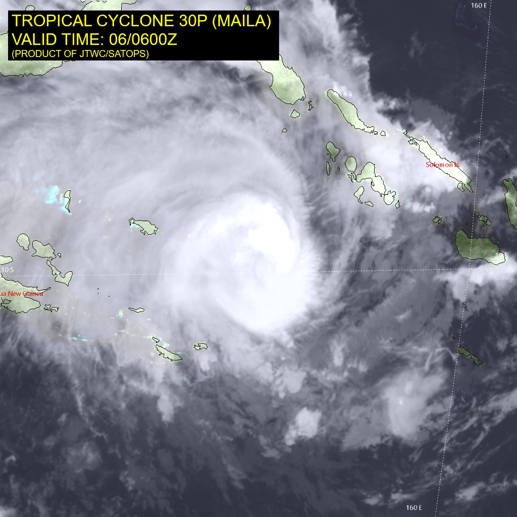
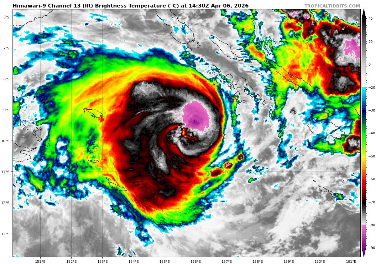
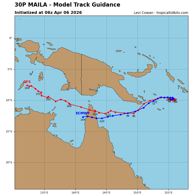
Tropical Cyclone 30P (Maila)
According to the JTWC warning number 9, sustained winds are 90 knots with gusts to 110 knots
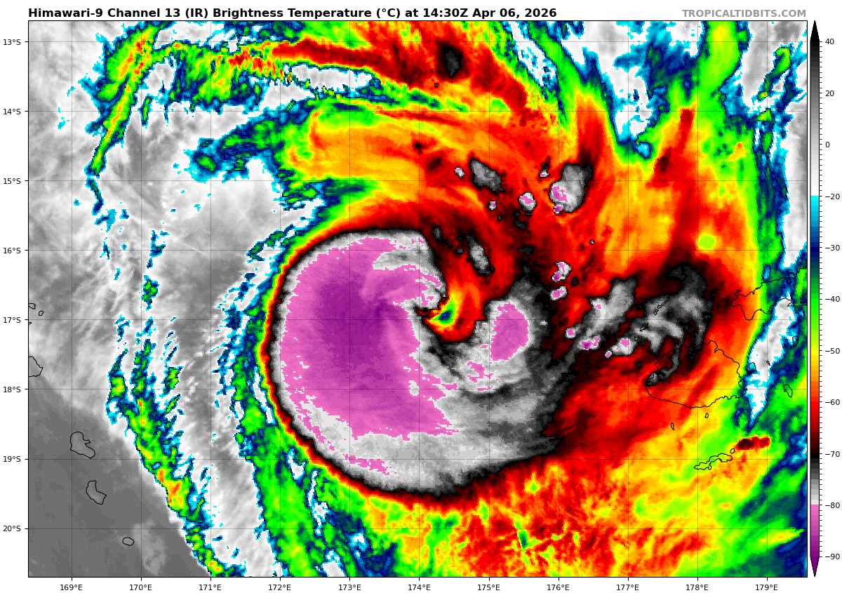
Animated multi-spectral satellite imagery (msi) depicts a compact central dense overcast (cdo) feature quasi-stationary in the Solomon Sea. Over the past six hours, animated enhanced infrared (eir) imagery shows a transient eye attempting to develop, with another attempt ongoing at the present time. However, there is still a moderate amount of vortex tilt due to persistent moderate easterly shear (currently estimated at 16 knots by cimss). While deep convective hot towers consistently form on the northern side of the nascent eye (as depicted in recent microwave imagery), they fail to rotate upshear due to the moderate shear, inhibiting intensification. Thus the system has been relatively stagnant in terms of intensity for the past 12 hours.
Environmental conditions are favorable, with moderate easterly shear, warm ssts and good equatorward outflow. a notable negative factor is the upwelling of cooler waters, with the latest ohc and sst analyses suggesting the leading edge of the cooler water may already be reaching the surface.
Tropical cyclone 30P (Maila) is forecast to continue meandering around the Solomon Sea for the next 36-48 hours in a weak and competing steering pattern. Currently, the northwesterly gradient flow to the north appears to be slightly ahead in terms of the primary steering influence, pushing TC 30P slowly east-southeastward. The gradient is already beginning to weaken however, and by 36 hours should be weak enough to allow a gradual change in the trajectory TC 30P, with the system expected to slowly loop north then westward by 48 hours.
After 48 hours, ridging building to the east of TC 30P will initiate a kick-out towards the west, then after 72 hours, the str over Australia is forecast to build and move eastward to a position south of TC 30P. This will result in an accelerating trajectory towards west-southwest through 120 hours. The system is forecast to clip the far southeastern tip of Papua New Guinea, passing close to the eastern approaches of Milne Bay around 96 hours, then moving into the far northern reaches of the Coral Sea by the end of the forecast period.
Regarding intensity, the system has only a short window of opportunity to gain further intensity, before significantly cooler waters reach the surface and choke off its energy source. The forecast calls for a peak of 95 knots at 12 hours, then a leveling off period, followed by rapid
weakening through 48 hours as models predict sea surface temperatures could drop as low as 23c in the cold upwelled region. After the system kicks out to the west and away from the cold pool, a period of re-intensification is forecast, with a second peak of around 90 knots expected around 72 hours. How high this second peak reaches ultimately depends on how much the system weakens while loitering over the cold pool, which potentially could be much more than
currently forecast.
As the system moves over the tip of Papua New Guinea, the vortex is likely to be shredded, along with significant inflow disruption, leading to a substantial weakening. While the system should recover once in the Coral Sea, forecast moderate shear will keep a lid on re-intensification, though there is considerable uncertainty in this final forecast point due to
uncertainty in the exact track beyond 72 hours.
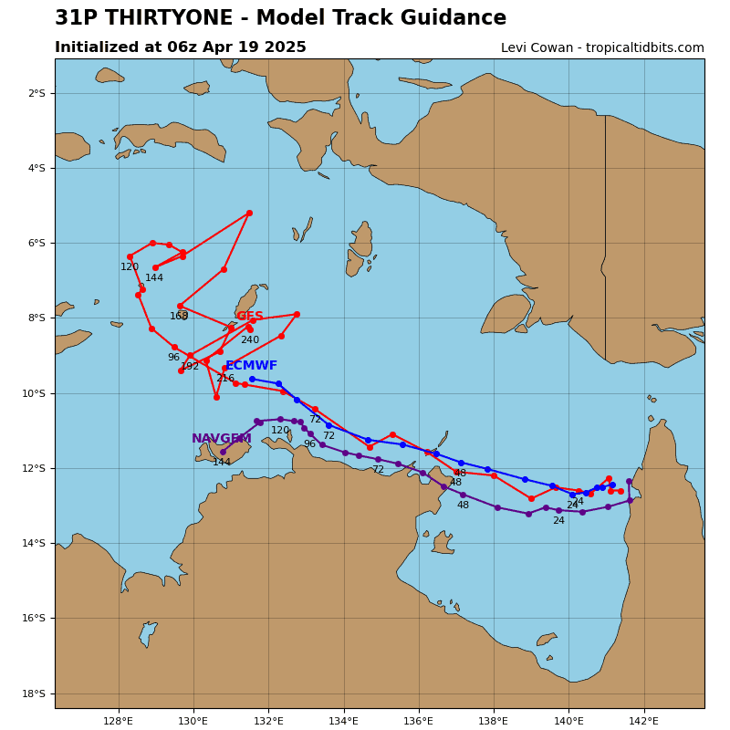
Tropical Cyclone 31P (Vaianu)
According to the JTWC warning number 7, sustained winds are 100 knots with gusts to 125 knots
Animated enhanced infrared (eir) satellite imagery depicts a compact system, with a symmetrical ball of deep convection arrayed around a nascent pinhole eye. The strongest of the convection is arrayed across the southern semicircle of the circulation, consistent with the 10-15 knots of shear coming down on the system from the north. Vortical hot towers (vhts) can be seen developing along the southern flank of the nascent eye feature, which has been a persistent feature for the past six hours, but due to the persistent northerly shear, they are failing to wrap upshear and thus the eye has been unsuccessful in fully emerging. A 061125z gmi color-enhanced 37ghz image revealed a well-formed, highly symmetrical microwave eye, with strong convection on the southeastern and southern flanks, while only weak convection is present in the northwestern quadrant.
Environmental conditions remain favorable in general, with low deep-layer shear, warm ssts and vigorous poleward outflow.
Tropical cyclone 31P (Vaianu) appears to have finally achieved vortex alignment, and after a period of relatively slow forward speed, has begun to accelerate southeastward. A straight southeastward track, along the western flank of the deep str near Samoa, is forecast for the next 72 hours. By 72 hours, TC 31P passes under the axis of a strengthening subtropical jet max and begins to be both pulled in towards a 200mb trough, while simultaneously being pushed southwestward along the western side of a rapidly building ridge to the east which builds
poleward to 40S. By the end of the forecast, TC 31P will be tracking southwestward towards the north island of New Zealand.
Regarding intensity, the system has another 24 hours worth of favorable conditions to intensify before wind shear increases sharply. Anticipating an eye to develop in the near-term, the forecast calls for the system to intensify to a peak of 105 knots within the next 12 to 24 hours, then begin to rapidly weaken under the influence of high northwesterly shear. The system crosses the 26c isotherm around 60 hours. Once the system crosses the axis of the subtropical jet, it moves into the equatorward side (under an upper-level trough or low) of a large rex block that develops between Fiji and New Zealand. At this point, ssts will be in the 22-24c range.
However, all global models indicate the system will retain its warm core and remain relatively moist through a deep layer of the atmosphere, though under a cold 200mb low, the forecast calls for extratropical transition (ett) beginning at 72 hours, completing by the end of the forecast. However, a more accurate description would be to call the remnants of TC 31P a hybrid warm core cyclone. Under favorable, low shear conditions and with a warm low- to mid-level vortex under a cold low aloft, the system could in fact re-intensify or at least maintain intensity as it undergoes transition to a hybrid cyclone.