
")
Current Snapshot
For all the latest updates visit: DisasterAWARE
GOES18-TPW-13-900×540
tc
27P_211200sair
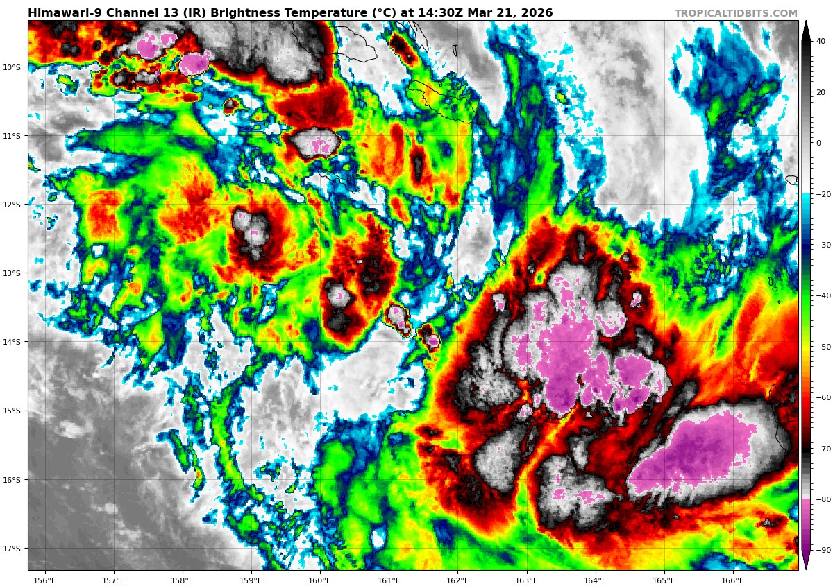
himawari9_ir_27P_202603211430_lat-13.1-lon136.8
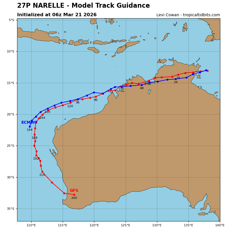
27P_tracks_latest
himawari9_ir_98P_202603211430_lat-13.0-lon161.3
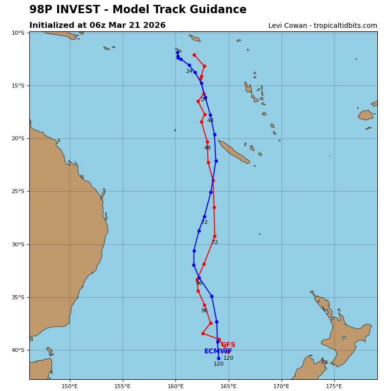
98P_tracks_latest
By PDC’s Senior Weather
Specialist Glenn James

The Pacific Disaster Center’s (PDC Global) Saturday, March 21, 2026, Tropical Cyclone Activity Report…for the Pacific Ocean, the Indian Ocean, and adjacent Seas
Current Tropical Cyclones:
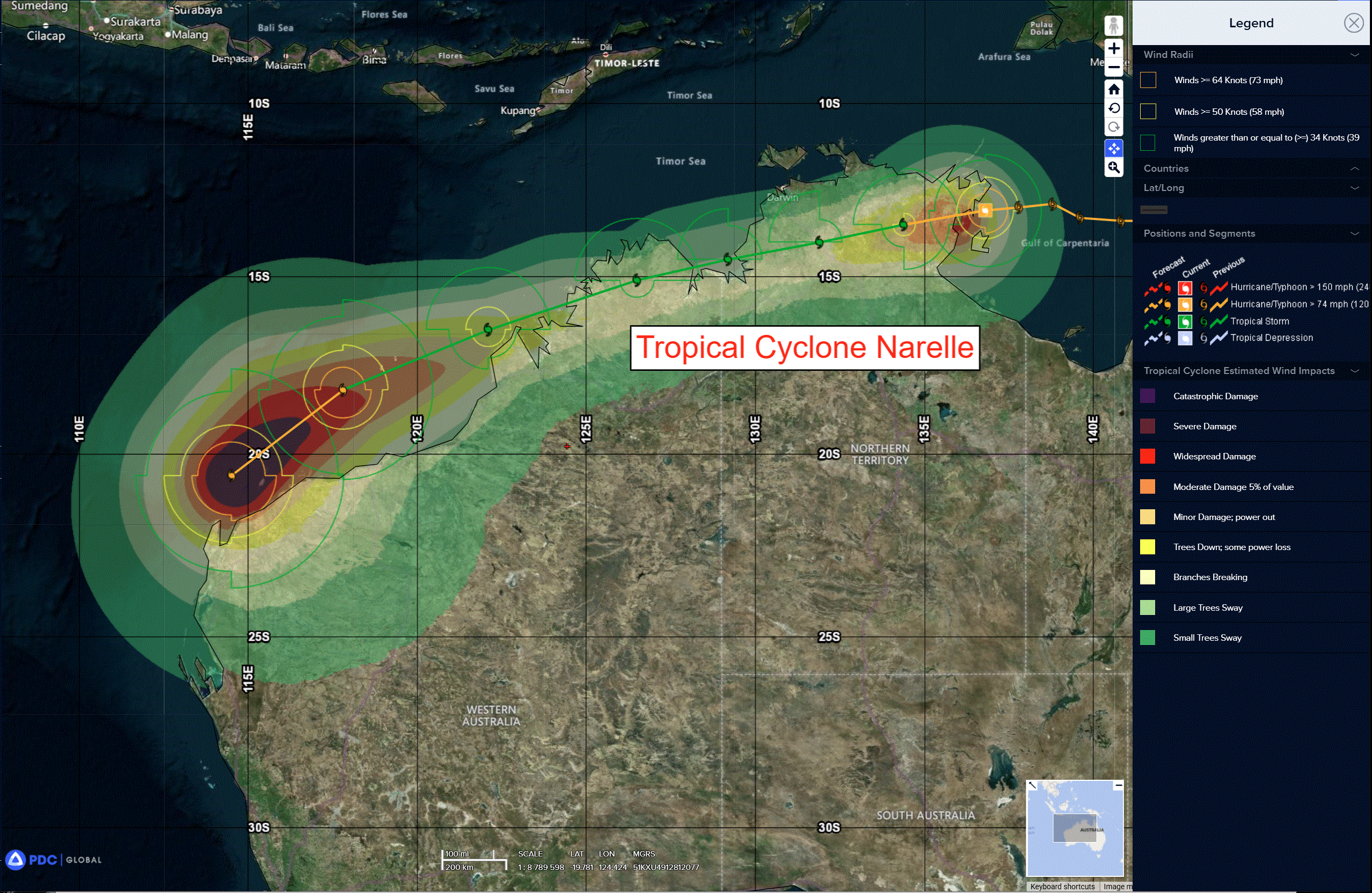
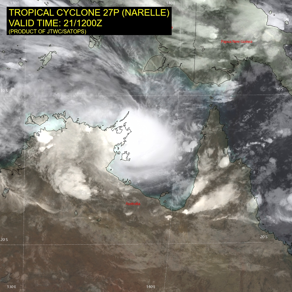
Tropical Cyclone 27P (Narelle)…is located approximately 198 NM east-southeast of Darwin, Australia
Northeast Pacific Ocean: There are no Tropical Cyclones
The last regularly scheduled Tropical Cyclone Activity Report of the 2025 eastern North Pacific Hurricane Season has been issued. Routine issuance of this section of the PDC product will resume on May 15, 2026. During the off-season, Special Tropical Weather Outlooks will be issued as conditions warrant by the NHC.
Central Pacific Ocean: There are no Tropical Cyclones
The 2025 central North Pacific hurricane season has ended. As such, the final routine Tropical Cyclone Activity Report for the 2025 season has been issued. Routine issuance of this section of the PDC product will resume on June 1, 2026. During the off-season, Special Tropical Weather Outlooks will be issued as conditions warrant by the CPHC.
Western Pacific, Indian Ocean, and adjacent Seas:
SW Pacific Ocean
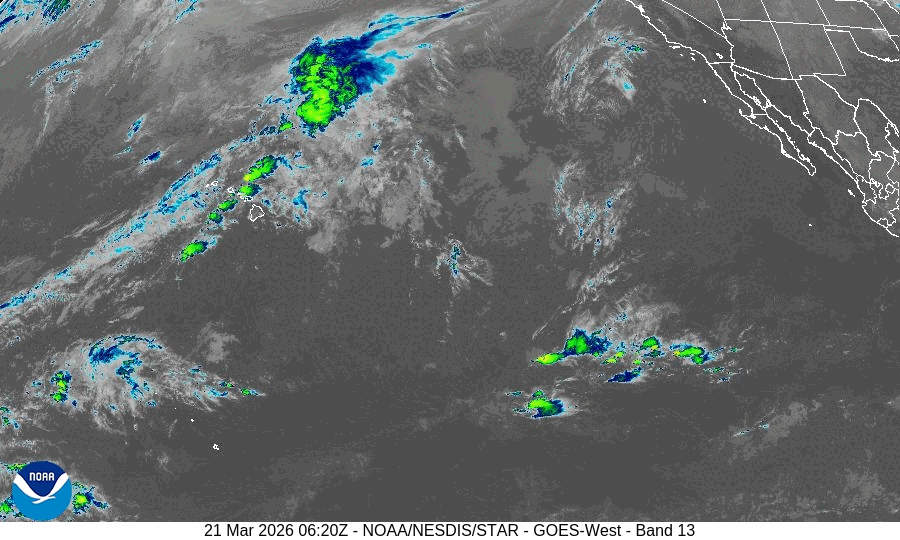
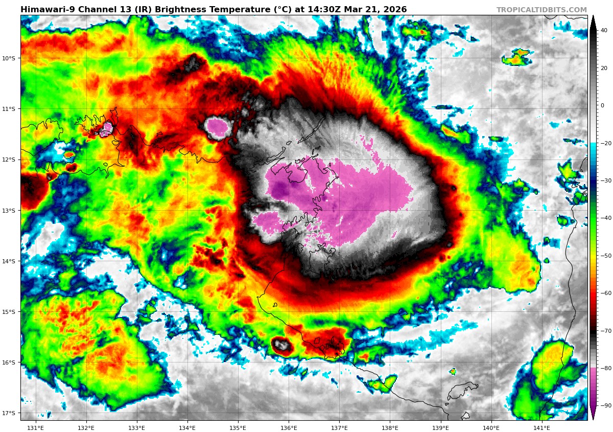
Tropical Cyclone 27P (Narelle)
According to the JTWC warning number 17, the sustained winds were 55 knots with gusts to near 70 knots
Animated multi-spectral satellite imagery (msi) depicts tropical cyclone 27P (Narelle) with a formative eye feature and extremely cold cloud tops within the eastern semicircle of the system. The symmetry of the vortex has improved over the past 6 hours, with convection now wrapping around the southern semicircle more prominently. A 210432z amsr2 36 ghz microwave image revealed a well-defined microwave eye feature at the surface.
Environmental analysis indicates that Narelle is currently placed within a favorable environment characterized by strong equatorward outflow aloft, moderate (15-20 kts) easterly vertical wind shear, and warm (29-30 c) sea surface temperatures.
TC 27P is forecast to track west-southwestward, along the northern periphery of a str to the south through 96 hours. Landfall along the eastern coast of the top end is expected to occur in about 6 hours, southwest of Gove. TC Narelle will then traverse across the top end, south of Darwin, and
emerge over the southern portion of the Bonaparte Gulf around 42 hours. Narelle will then make another landfall, northwest of Wyndham, near 48 hours and once again emerge back over water, east of Adele Island, just before 72 hours.
The system will then continue on a west-southwestward trajectory through 96 hours as it nears the northwestern extent of the str. After 96 hours, Narelle will turn more southwestward as it begins a poleward track, around the ridge axis.
Regarding intensity, Narelle is forecast to only have another 6 hours to intensify before making landfall and rapidly weakening. The system is forecast to drop to 35 kts by 36 hours due to terrain interaction, which will then persist through around 60 hours, where it emerges back over water near Adele Island. The system will then begin to recuperate after an extended amount of time over land as it takes advantage of a highly favorable environment.
Rapid intensification is forecast to occur from 96 to 120 hours from 65 kts
to 95 kts as strong poleward outflow, low shear, and warm sea surface temperatures allow for significant redevelopment.
>>> There’s an area of disturbed weather being referred to as Invest 98P, which is located approximately 205 NM south of Honiara, Solomon Islands
Animated multi-spectral satellite imagery depicts an obscured low level circulation center with convective banding developing in all quadrants. A 212237z ascat pass shows a defined circulation with a swath of 25 kt winds on the eastern periphery of 98P.
Environmental analysis reveals a favorable environment for development with strong poleward and weak equatorward outflow, low vertical wind shear (10-15 kts), and warm sea surface temperatures (28-29 c).
The ensemble models are more aggressive in the formation of 98P than the deterministic models, though both model types agree on 98P tracking southward while slowly intensifying over the next 24-48 hours.
Maximum sustained surface winds are estimated at 25 to 30 knots.
The potential for the development of a significant tropical cyclone within the next 24 hours is upgraded to high.