
")
Current Snapshot
For all the latest updates visit: DisasterAWARE
2
7
e
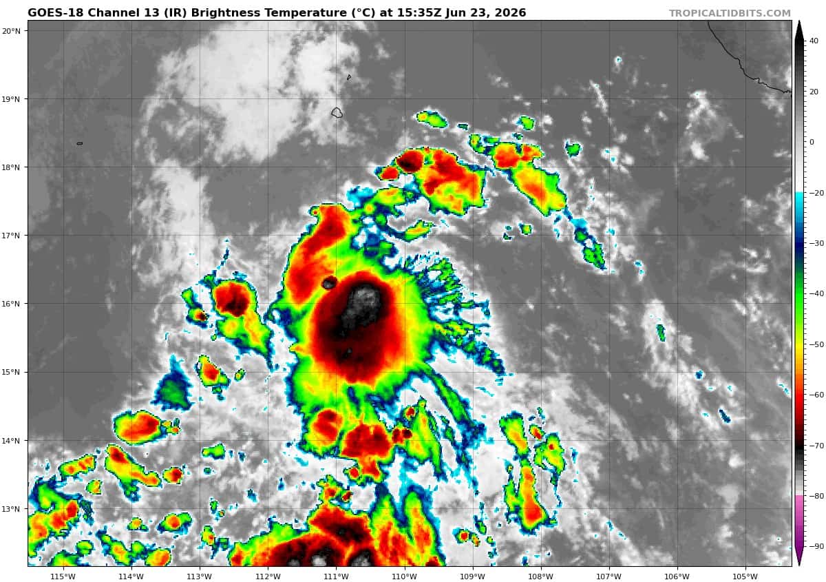
goes18_ir_94E_202606231535_lat15.8-lon-109.4

94E_tracks_latest
c
22222
07W_231200sair

07W_tracks_latest
08W_231200sair

08W_tracks_latest
By PDC’s Senior Weather
Specialist Glenn James

The Pacific Disaster Center’s (PDC Global) Tuesday, June 23, 2026, Tropical Cyclone Activity Report…for the Pacific Ocean, the Indian Ocean, and adjacent Seas
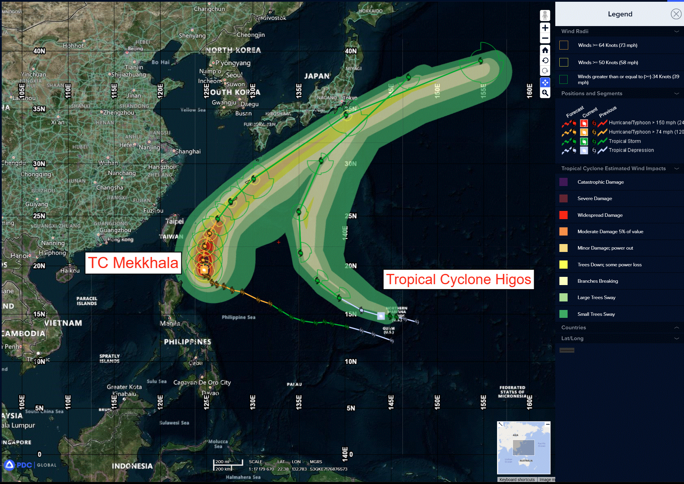
Current Tropical Cyclones:
Tropical Cyclone 07W (Mekkhala)…is located 374 NM south-southwest of Kadena AB
Tropical Cyclone 08W (Higos)…is located 194 NM west-northwest of Andersen AFB
Northeast Pacific Ocean: There are no Tropical Cyclones
Central and Western Portion of the East Pacific:
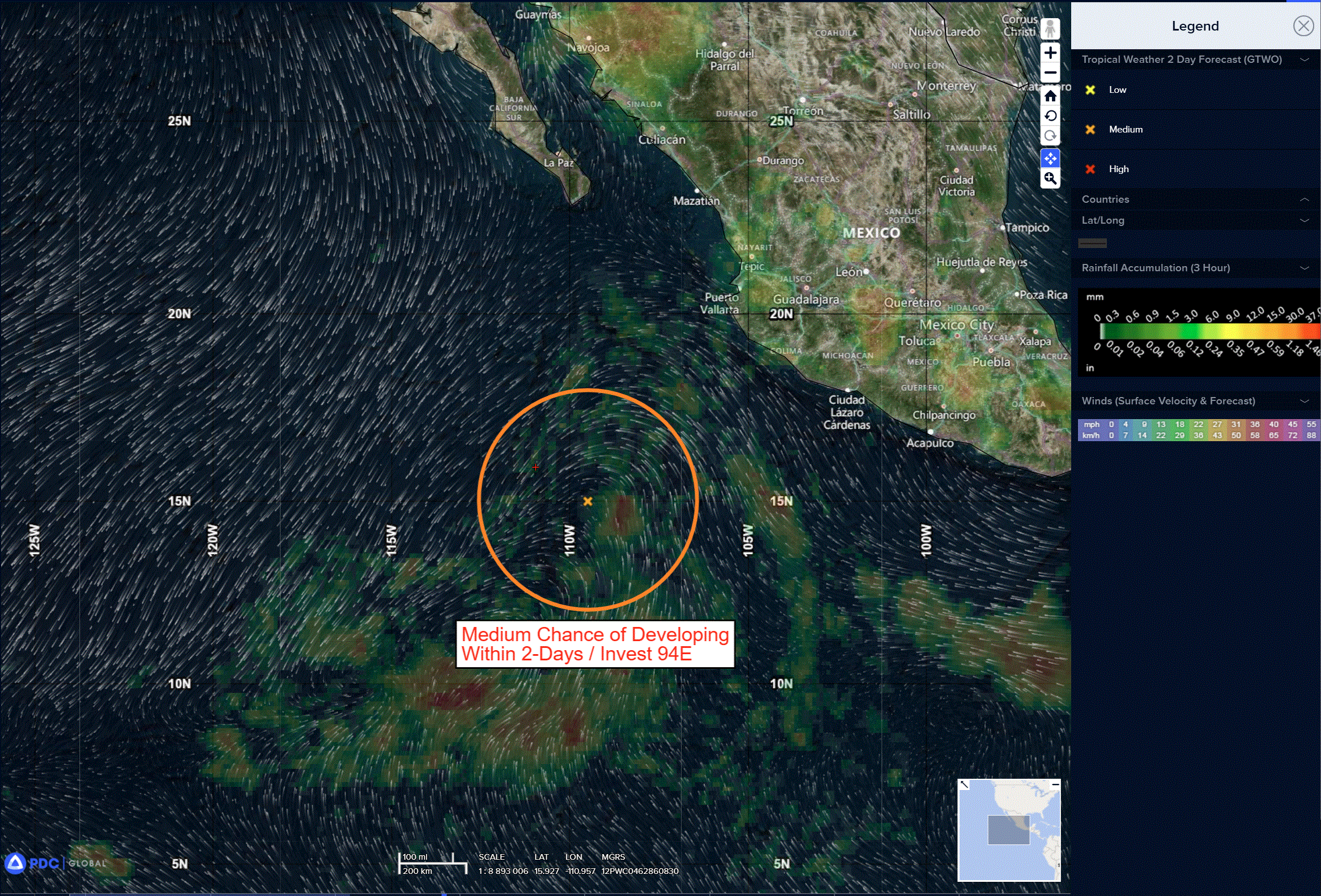
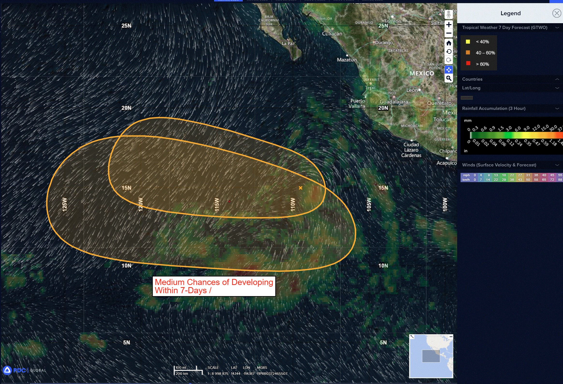
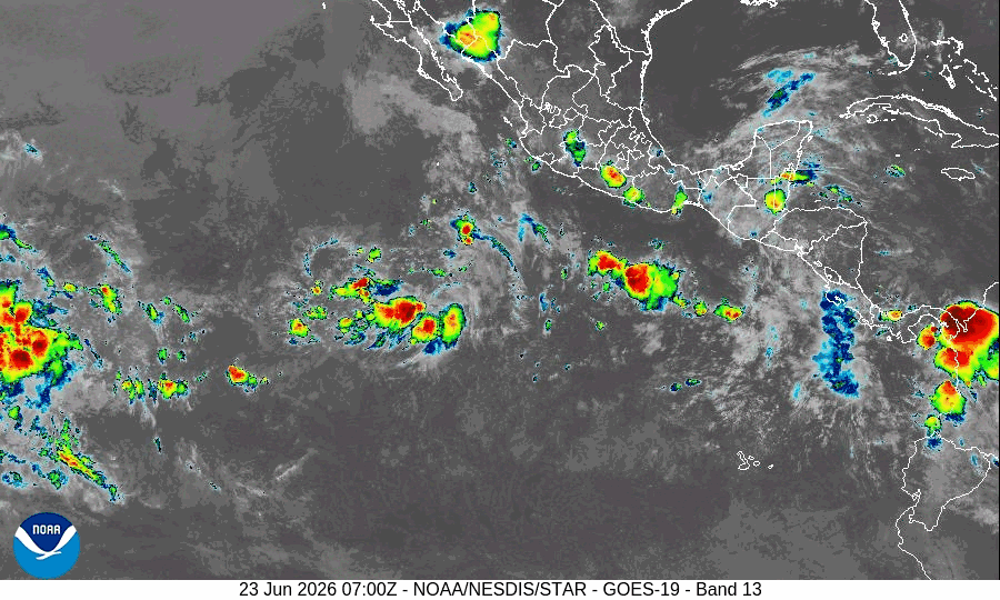
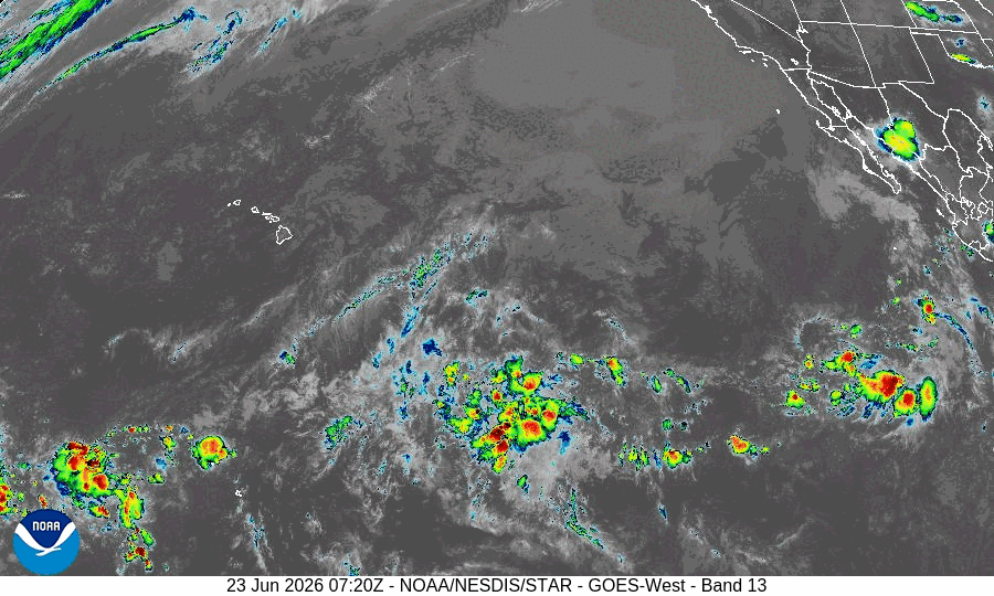
Invest 94E
>>> Showers and thunderstorms persist with an area of low pressure located several hundred miles south-southwest of the southern tip of the Baja California Peninsula. Recent satellite wind data suggest the circulation is a little better defined and a tropical depression could still form within the next day or so while environmental conditions remain favorable for development. This system is moving to the west to west-northwest at 15 to 20 mph, and by Thursday it is forecast to move into an unfavorable environment, ending its chances for further development.
* Formation chance through 48 hours…medium…50 percent
* Formation chance through 7 days…medium…50 percent
Central and western East Pacific:
>>> A low pressure system is likely to form this weekend or early next week over the central portion of the East Pacific basin. Environmental conditions are forecast to be conducive for gradual development of this system thereafter. A tropical depression could form by the early to mid part of next week as the system moves westward to west-northwestward at 10 to 15 mph.
* Formation chance through 48 hours…low…near 0 percent
* Formation chance through 7 days…medium…50 percent
Central Pacific Ocean: There are no Tropical Cyclones
Central and Western Portion of the East Pacific:
Invest 94E
>>> Showers and thunderstorms persist with an area of low pressure located several hundred miles south-southwest of the southern tip of the Baja California Peninsula. Recent satellite wind data suggest the circulation is a little better defined and a tropical depression could still form within the next day or so while environmental conditions remain favorable for development. This system is moving to the west to west-northwest at 15 to 20 mph, and by Thursday it is forecast to move into an unfavorable environment, ending its chances for further development.
* Formation chance through 48 hours…medium…50 percent
* Formation chance through 7 days…medium…50 percent
Western Pacific, Indian Ocean, and adjacent Seas:
Western Pacific
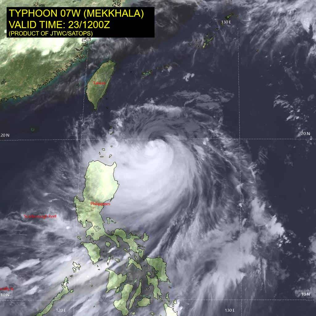
Tropical Cyclone 07W (Mekkhala)
According to the JTWC Warning number 22…sustained winds are 75 knots with gusts to 90 knots
Animated multi-spectral satellite imagery (msi) depicts a cloud-filled eye surrounded by convective banding wrapping into the core. The convection is notably shallower in the northern semicircle where north-northeasterly shear is applying pressure to the system. Animated water vapor imagery reveals that poleward outflow remains weak while the equatorward channel has persisted with moderate outflow. A 230453z amsr-2 36 ghz microwave image shows a well-defined microwave eye and further demonstrates the asymmetry of convective banding seen in the msi.
The environment is characterized as unfavorable as the slow speed of advance has enhanced upwelling of cooler water, combined with
moderate (20-25 kts) north-northeasterly vertical wind shear.
Typhoon 07W (Mekkhala) has slowed in its generally northwestward track over the past 6 hours as it tracks around the axis of the steering str centered to the northeast. The track is forecast to maintain a primarily northward component over the next 36 hours as the system continues around the ridge axis, then turn northeastward with a slightly faster track speed as it approaches Okinawa. The cpa to Kadena AB is expected at 260100z as the center of TY Mekkhala tracks along the northwest coast of Okinawa. After 72 hours, the system is forecast to accelerate rapidly on a northeastward track and skirt along the southeastern coast of
Honshu, passing just south of Tokyo after 96 hours.
The already unfavorable environmental conditions, with cooler sst and increasing vws, will continue to promote steady weakening through 96 hours. After 96 hours, baroclinic forcing will initiate extratropical transition and should allow 07W to maintain 50-55 kt intensity through the end of the forecast period, with extratropical transition expected to be complete by 120 hours.
Western Pacific
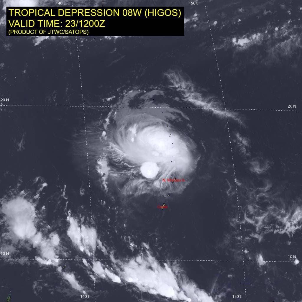
Tropical Cyclone 08W (Higos)
According to the JTWC Warning number 7…sustained winds are 30 knots with gusts to 40 knots
Animated enhanced infrared (eir) satellite imagery depicts a compact and nearly fully exposed low-level circulation center (llcc) with bursts of deep convection offset to the north. The vortex continues to be significantly tilted northward with height. overall, the appearance of 08W has degraded over the past 6 hours with less definition in the llcc and more disorganized convection. Additionally, a 231127z metop-c ascat pass revealed that the winds within the northern semicircle have weakened to 25-30 kts, and winds within the southern semicircle are now around 10 kts.
Environmental analysis indicates that 08W is in a marginal environment characterized by warm (29-30 c) sea surface temperatures offset by weak outflow aloft and moderate (15-20 kts) southerly vertical wind shear.
08W is forecast to track northwestward, along the southwestern periphery of the elongated str through 48 hours. Near 48 hours, the str is expected to build and become more symmetric. 08W will then begin to round the western extent of the str with a northward turn. The track will then become northeastward as 08W accelerates along the northwestern periphery of the str. The system is expected to remain well off the coast of Honshu as it commences its recurve. Extratropical transition is forecast to begin at 72 hours with completion around 96 hours as the system becomes embedded within the strong mid-latitude westerly flow.
In terms of intensity, 08W is forecast to gradually intensify over the next 60 hours to a peak of 45 kts. Vertical wind shear is expected to lessen, which could allow the vortex to become more vertically aligned. However, dry air and interaction with the wind field of TY 07W (Mekkhala) will limit the intensification of the system. Near 72 hours, sea surface temperatures will quickly drop and shear will increase, causing 08W to weaken. By 96 hours, westerly shear will increase to over 50 kts and sea surface temperatures will drop below 20 c as 08W transitions into a cold-core cyclone.
There still remains a chance that 08W becomes absorbed by the wind field of 07W around 72 hours. This is especially true if 08W is unable to
develop very much. It needs to form a discrete, tight circulation in order to survive the passage close to 07W.