
")
Current Snapshot
For all the latest updates visit: DisasterAWARE
2
7
GOES19-EEP-13-900×540
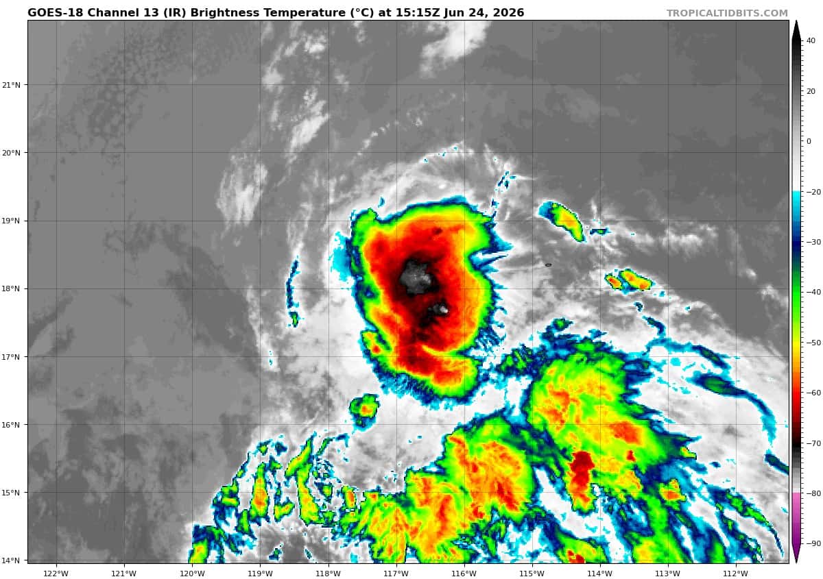
goes18_ir_94E_202606241515_lat17.8-lon-116.0
94E_tracks_latest
c
wpac
07W_241200sair

07W_tracks_latest
08W_241200sair
08W_tracks_latest
By PDC’s Senior Weather
Specialist Glenn James

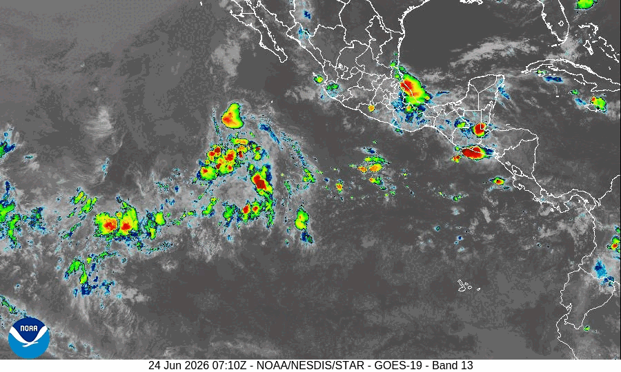
The Pacific Disaster Center’s (PDC Global) Wednesday, June 24, 2026, Tropical Cyclone Activity Report…for the Pacific Ocean, the Indian Ocean, and adjacent Seas
Current Tropical Cyclones:
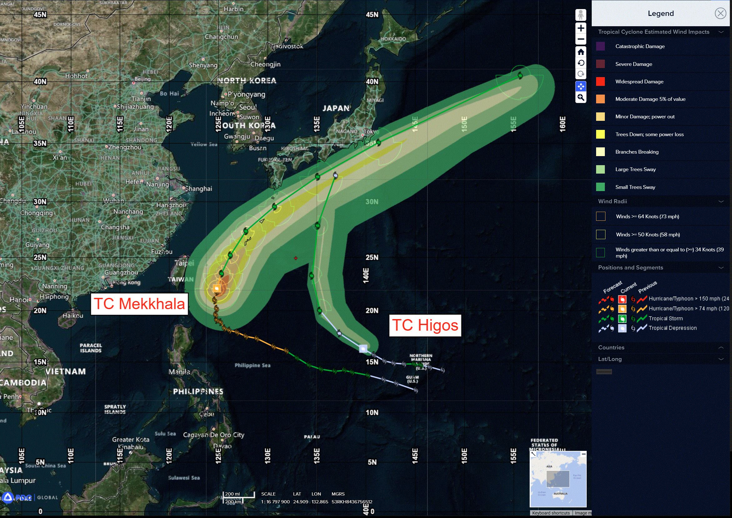
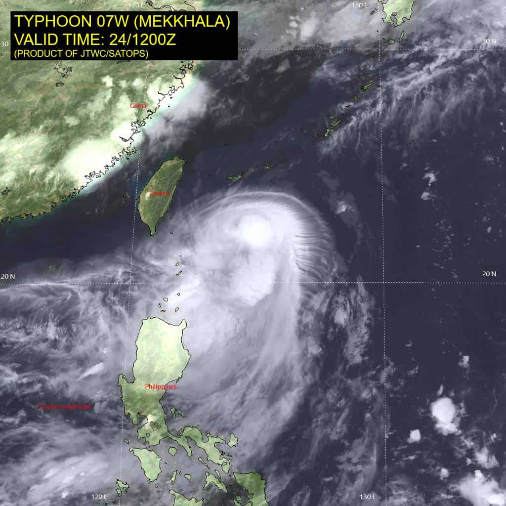
Tropical Cyclone 07W (Mekkhala)…is located 216 NM southwest of Kadena AB
Tropical Cyclone 08W (Higos)…is located 754 NM southeast of Kadena AB
Northeast Pacific Ocean: There are no Tropical Cyclones
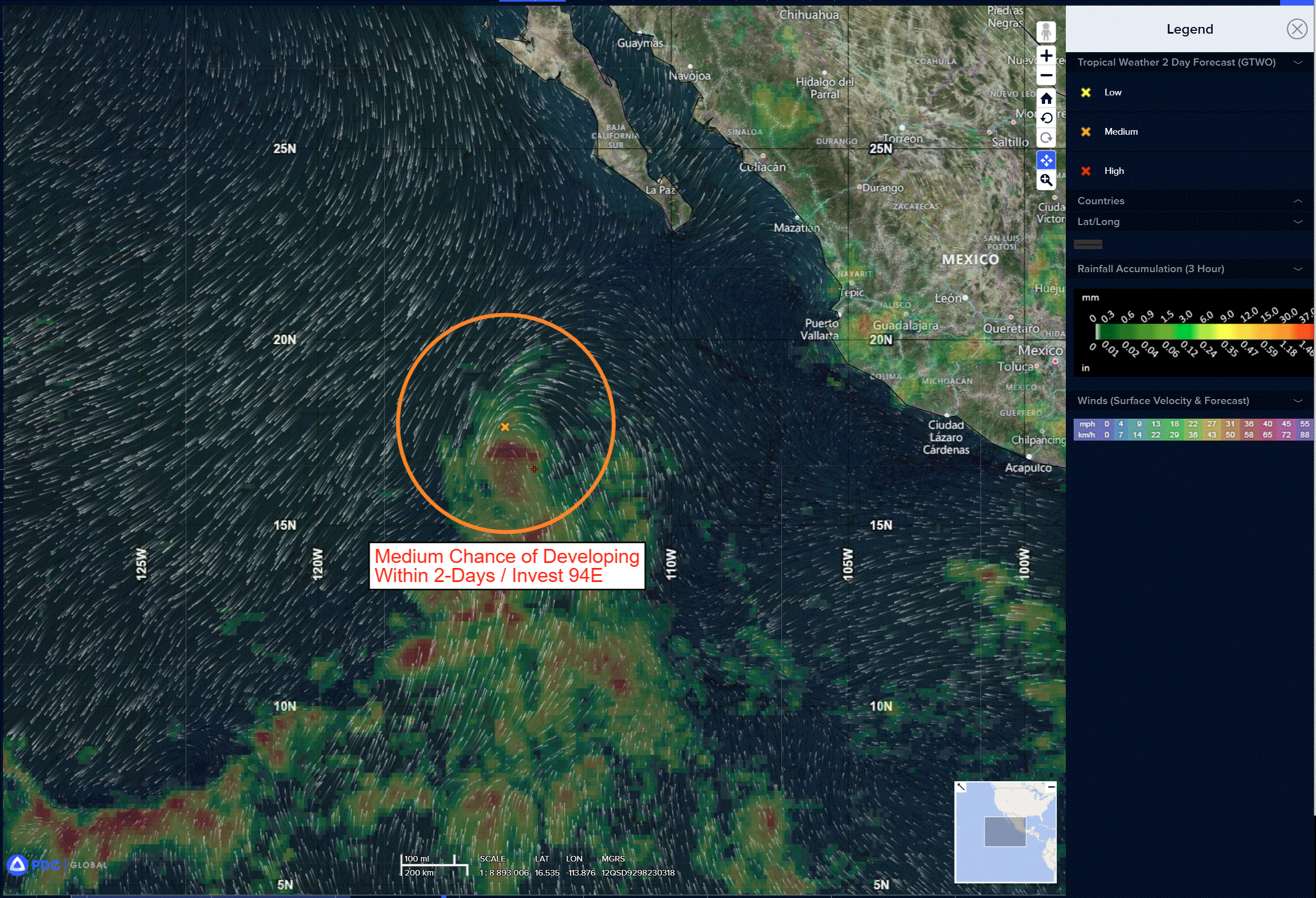
Central and Western Portion of the East Pacific:
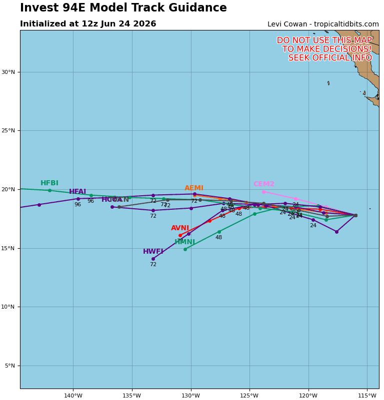
Invest 94E
>>> Showers and thunderstorms continue to decrease in association with an area of low pressure located several hundred miles west-southwest of the southern tip of the Baja California Peninsula. This system is moving quickly westward over cooler waters, and additional development is unlikely.
* Formation chance through 48 hours…low…10 percent
* Formation chance through 7 days…low…10 percent
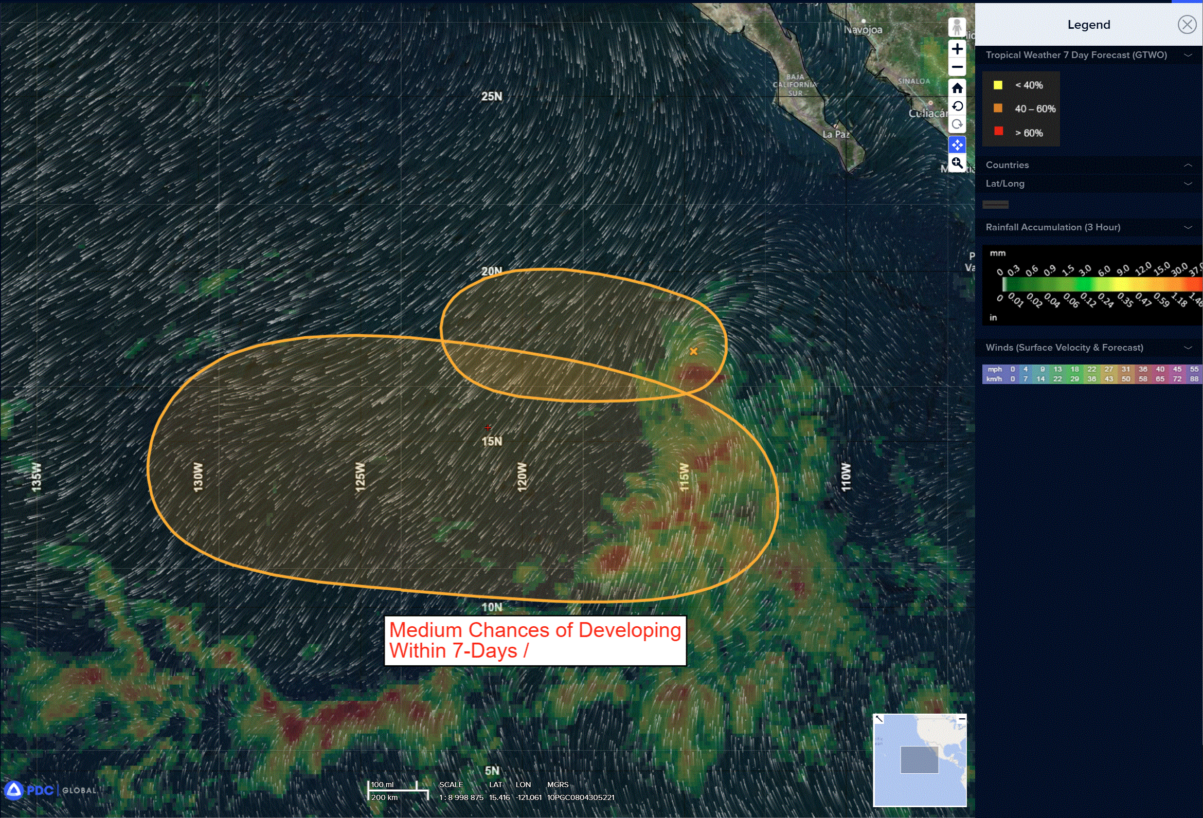
Central and western East Pacific:
>>> A low pressure system is likely to form this weekend or early next week over the central portion of the East Pacific basin. Environmental conditions are forecast to be conducive for gradual development, and a tropical depression is likely to form by the early to middle part of next week as the system moves westward to west-northwestward at 10 to 15 mph.
* Formation chance through 48 hours…low…near 0 percent
* Formation chance through 7 days…high…70 percent
Central Pacific Ocean: There are no Tropical Cyclones
Central and Western Portion of the East Pacific:
Invest 94E
>>> Showers and thunderstorms continue to decrease in association with an area of low pressure located several hundred miles west-southwest of the southern tip of the Baja California Peninsula. This system is moving quickly westward over cooler waters, and additional development is unlikely.
* Formation chance through 48 hours…low…10 percent
* Formation chance through 7 days…low…10 percent
Central and western East Pacific:
>>> A low pressure system is likely to form this weekend or early next week over the central portion of the East Pacific basin. Environmental conditions are forecast to be conducive for gradual development, and a tropical depression could form by the early to middle part of next week as the system moves westward to west-northwestward at 10 to 15 mph.
* Formation chance through 48 hours…low…near 0 percent
* Formation chance through 7 days…high…70 percent
Western Pacific, Indian Ocean, and adjacent Seas:
Western Pacific
Tropical Cyclone 07W (Mekkhala)
According to the JTWC Warning number 26…sustained winds are 50 knots with gusts to 65 knots
Animated multi-spectral satellite imagery (msi) depicts the low-level circulation center (llcc) of 07W partially exposed in the northern semicircle, with significant deep convection limited to the southern semicircle. Strong northeasterly vertical wind shear has continued to disallow the deep convection to wrap around to the northern side. Moderate equatorward outflow is evident in the animated water vapor imagery, along with a wedge of dry air to the north of the system that has yet to penetrate the core.
The environment is characterized as unfavorable, with still-warm sea surface temperatures being overcome primarily by high (30-35 kts) vws.
Typhoon 07W (Mekkhala) has continued on a northward trajectory as it rounds the western periphery of a deep-layer str centered to the northeast. Speed of advance has slowly increased over the last 12 hours and is expected to continue to do so over the next 48 hours as it recurves toward the northeast. The forecast track will pass parallel to the northwest coast of Okinawa beginning around 36 hours, with the cpa to Kadena AB expected at 251900z. After 48 hours the track speed continues to accelerate at a higher rate as the northeastward motion takes 07W on a track that parallels the southeastern coast of Honshu, just offshore. Of note, the Kanto Plain is well within the uncertainty envelope of track
guidance as the system approaches the Tokyo Bay region just after 72 hours.
The intensity is forecast to continue its steady decline throughout the forecast period, with a brief period of sustained intensity between 48-60 hours when vws decreases to less hostile values and poleward outflow gets a boost from a jet streak to the north. The system will begin extratropical transition before 72 hours as it moves poleward into the mid-latitude westerlies, completing the transition before 96 hours.
Western Pacific
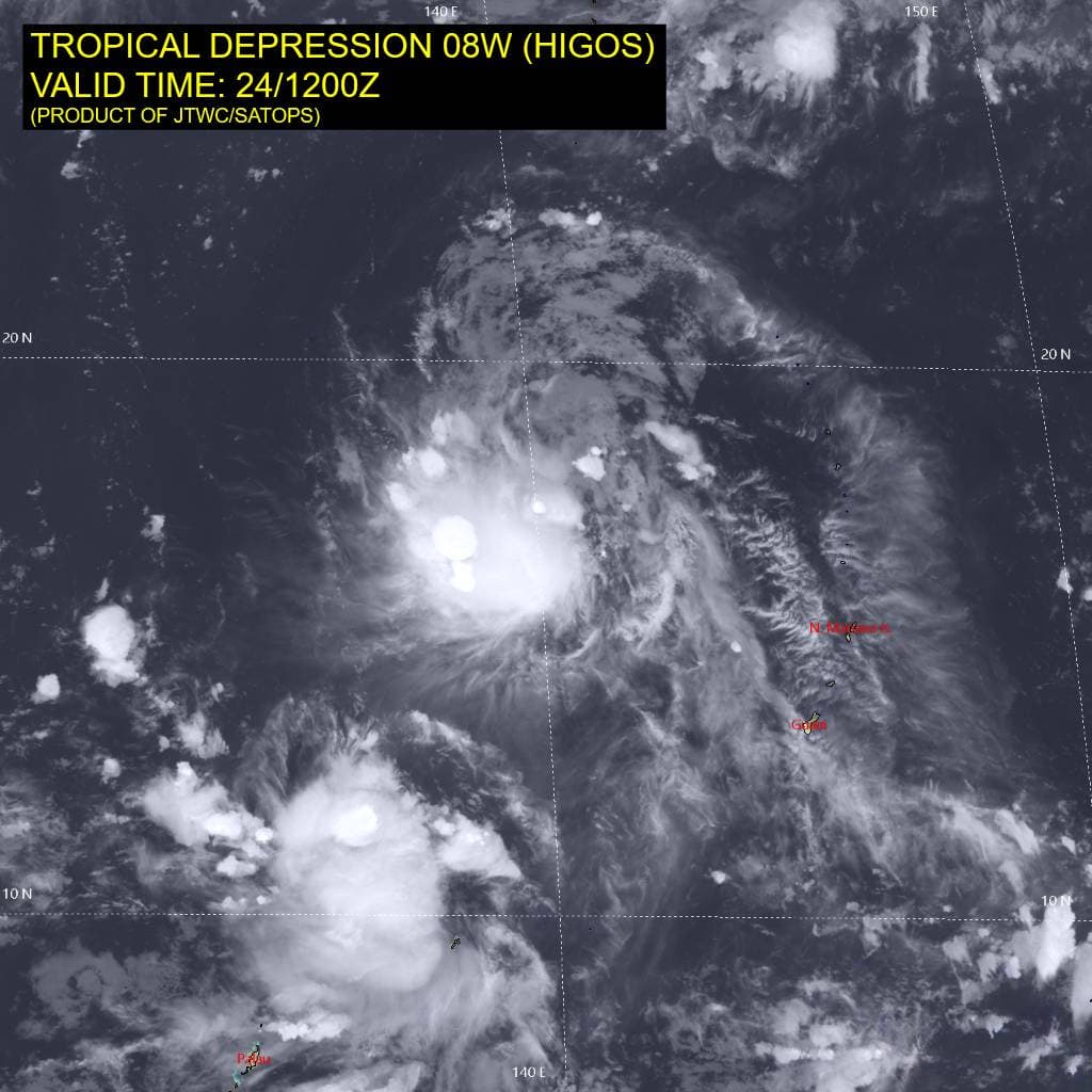
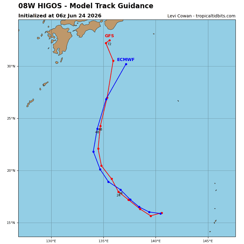
Tropical Cyclone 08W (Higos)
According to the JTWC Warning number 11…sustained winds are 40 knots with gusts to 50 knots
Animated enhanced infrared (eir) satellite imagery depicts tropical depression 08W (Higos) with disorganized flaring convection obscuring a compact low-level circulation center (llcc). The cimss adt and aidt are analyzed to be currently overestimating the intensity of the system.
Environmental analysis indicates that 08W is in a marginal environment characterized by weak outflow aloft,dry air over the western periphery, low (10-15 kts) southeasterly vertical wind shear, and warm (29-30 c) sea surface temperatures.
TD 08W is forecast to track northwestward, along the southwestern periphery of the str through 24 hours. Near 24 hours, the system will turn northward as it begins to round the western extent of the str. 08W will then begin to interact with the wind field of the much larger TY 07W (Mekkhala) around 36 hours. As 08W continues on a poleward track, the two systems will close in on each other. It is not clear whether the binary interaction will result in a merge, or simply a dissipation of 08W within the outer edge of the wind field of 07W. The distance of the two vorticies will likely be the primary factor in determining the fate of 08W. If the distance is closer, a complete merge is more likely. Even if a merge does not occur, 08W is expected to open up into a wave and become untrackable. The timing of the interaction and potential merge remains uncertain due to the reliance on the translation speed of both 08W and 07W. As it stands, the dissipation of 08W is forecast to occur near 60 hours, south of Honshu. There still remains a possibility that 08W outruns 07W and recurves before enough interaction with 07W occurs, but that scenario is now analyzed to be less likely.
In terms of intensity, 08W is forecast to maintain a steady intensity or marginally intensify over the next 48 hours as the vortex attempts to axisymmetrize. The interaction with 07W will also inhibit any significant development.
>>> There’s an area of disturbed weather being referred to as Invest 95W, which is located approximately 901 NM east-southeast of Kwajalein
Animated multi-spectral satellite imagery (msi) depicts a weakly-defined and broad low-level circulation center (llcc) with isolated and flaring
convection.
Environmental analysis for the area indicates a marginally favorable environment for cyclonegenesis, with low to moderate vertical wind shear (15-20 kts), good poleward outflow aloft, and warm sea surface temperatures (29-30c).
Global ensemble and deterministic models characterize 95W on a steady intensification trend with gfs/gefs having higher intensities over the next 36 hours.
Maximum sustained surface winds are estimated at 12 to 18 knots.
The potential for the development of a significant tropical cyclone within the next 24 hours is low.