
")
Current Snapshot
For all the latest updates visit: DisasterAWARE
epac
1
2
jangmi
06W_311200sair
himawari9_ir_06W_202605311510_lat22.8-lon127.7
06W_tracks_latest
By PDC’s Senior Weather
Specialist Glenn James

The Pacific Disaster Center’s (PDC Global) Sunday, May 31, 2026, Tropical Cyclone Activity Report…for the Pacific Ocean, the Indian Ocean, and adjacent Seas
Current Tropical Cyclones:
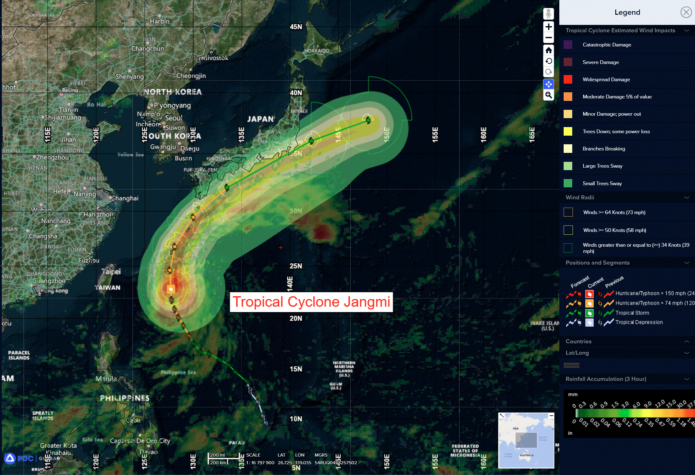
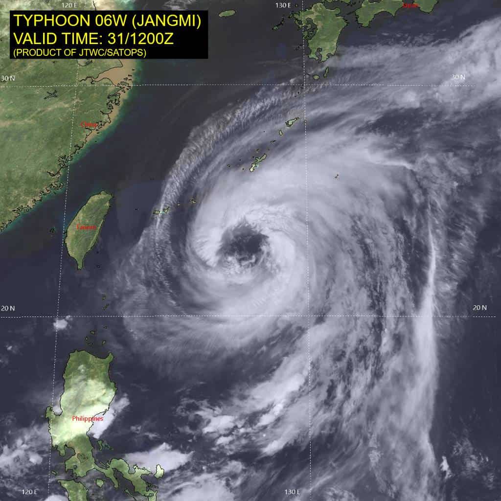
Tropical Cyclone 06W (Jangmi)…is located approximately 123 NM south-southwest of Kadena AB
Northeast Pacific Ocean: There are no Tropical Cyclones
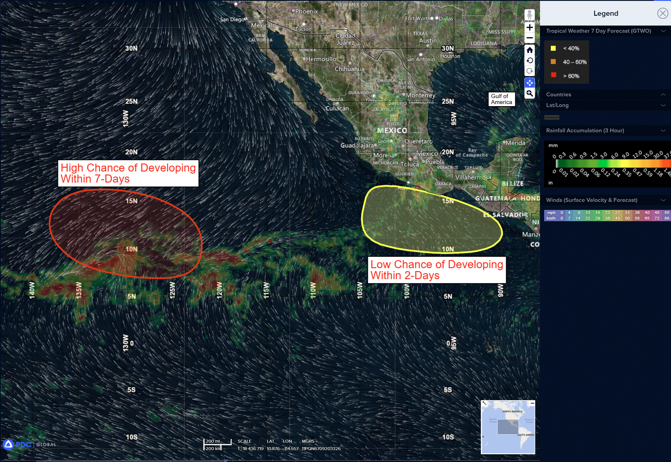
>>> Well Southwest of the Baja California Peninsula:
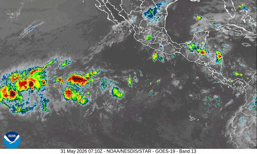
A broad area of low pressure located well southwest of the southern tip of the Baja California Peninsula is producing disorganized showers and thunderstorms.
Environmental conditions appear conducive for gradual development, and a tropical depression is likely to form during the middle part of the week while moving westward or west-northwestward at 10 to 15 mph across the western portion of the East Pacific.
* Formation chance through 48 hours…low…20 percent
* Formation chance through 7 days…high…90 percent
>>> Eastern East Pacific:
An area of low pressure may develop late this week or early next week south of the southern coasts of Mexico and Guatemala. Environmental conditions appear favorable for some development of this system thereafter, while it moves westward to west-northwestward at around 10 mph.
* Formation chance through 48 hours…low…near 0 percent
* Formation chance through 7 days…low…20 percent
Central Pacific Ocean: There are no Tropical Cyclones
Western Pacific, Indian Ocean, and adjacent Seas:
Western Pacific
Tropical Cyclone 06W (Jangmi)
According to the JTWC warning number 20 sustained winds were 65 knots with gusts to near 80 knots
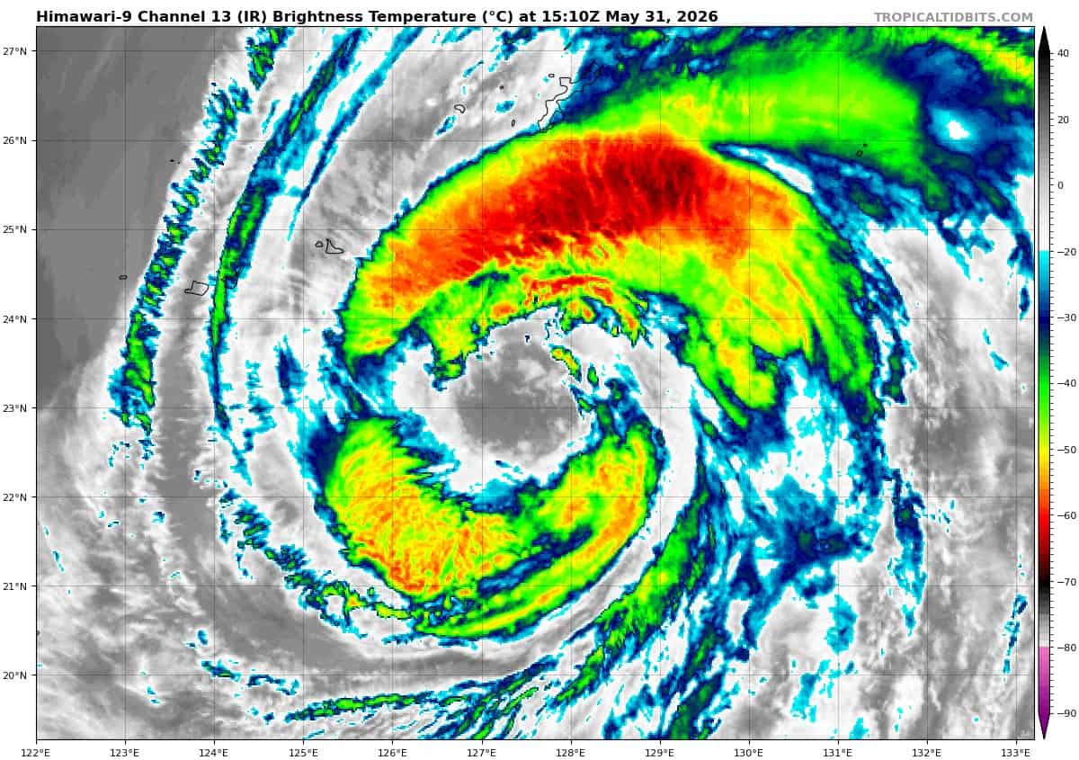
Typhoon 06W has maintained a consistent structural appearance over the past 24 hours, characterized by a large, ragged eye with multiple mesovortices rotating cyclonically along the inner edge of the eyewall. Six hours ago, visible and microwave imagery supported the analysis of at least four mesovortices within the eye. Concurrently, the most recent shortwave infrared (swir) animations,
along with a 310938z rcm-3 sar pass and a 310927z wsf-m 37ghz image, indicate that the system has achieved a degree of structural axisymmetrization, with only two mesovortices now evident.
Animated water vapor imagery depicts a moderately strong poleward outflow channel, flowing into the right rear entrance region of a jet max over central Honshu. To the northeast, animated swir and a 311243z ascat pass reveal a shear line positioned from just north of Minami Daito Jima eastward to near the northern Bonin Islands, where it transitions to a stationary frontal boundary.
Environmental conditions are marginally favorable, with declining ssts offset by enhanced outflow aloft and low vws.
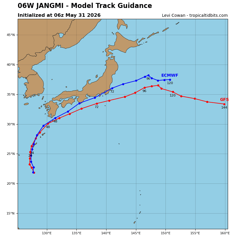
TY 06W has turned onto a northward heading, while slowing slightly, as it approaches the axis of the str centered southeast of Honshu. The system is forecast to track northward at roughly the same pace for the next 12 hours as it crosses the ridge axis, before turning northeastward and beginning to accelerate. TY 06W is projected to make landfall over Okinawa within the next 18-20 hours, subsequently tracking northeastward along the Ryukyu Chain through 24 hours. The system then continues to accelerate northeastward parallel to the northern Ryukyu Chain before passing south of Kyushu and Shikoku by 48 hours.
The system attains its maximum forward speed between 48 and 72 hours as it is steered northeastward along the tight gradient between the str to the south and the mid-latitude westerlies to the north. TY 06W is forecast to make a second landfall along the southern portion of the Izu Peninsula before rapidly transiting over the southern approaches to
Tokyo Bay and Yokosuka Proximate to 60 hours. The system rapidly decelerates after 72 hours, as the steering gradient collapses due to the str displacing southward and the remnant low translating beneath an upper-level low.
Regarding intensity, the system has reached its peak intensity and is forecast to maintain this intensity for 12 hours before beginning a steady weakening phase from 12 hours onwards. TY 06W will move over a sharp sst gradient and into sub-26c waters within the next 12 hours, which will initiate the weakening phase. More rapid weakening will ensue after 24 hours as westerly shear rapidly intensifies. The system is projected to undergo vertical decoupling near 48 hours due to strong shear; however, the associated wind field will remain robust as the remnant translates poleward. Extratropical transition begins around 60 hours, and will complete no later than 96 hours.