
")
Current Snapshot
For all the latest updates visit: DisasterAWARE
hawaii
1
22
jang
99999
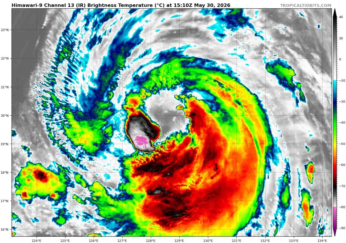
himawari9_ir_06W_202605301510_lat19.3-lon129.0

06W_tracks_latest
By PDC’s Senior Weather
Specialist Glenn James

The Pacific Disaster Center’s (PDC Global) Saturday, May 30, 2026, Tropical Cyclone Activity Report…for the Pacific Ocean, the Indian Ocean, and adjacent Seas
Current Tropical Cyclones:
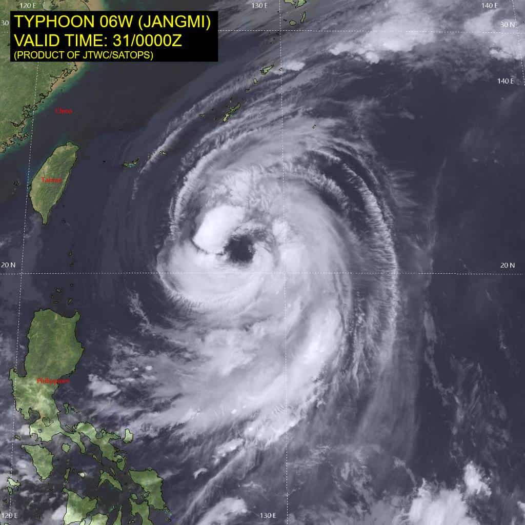
Tropical Cyclone 06W (Jangmi)…is located approximately 386 NM south of Kadena AB
Northeast Pacific Ocean: There are no Tropical Cyclones
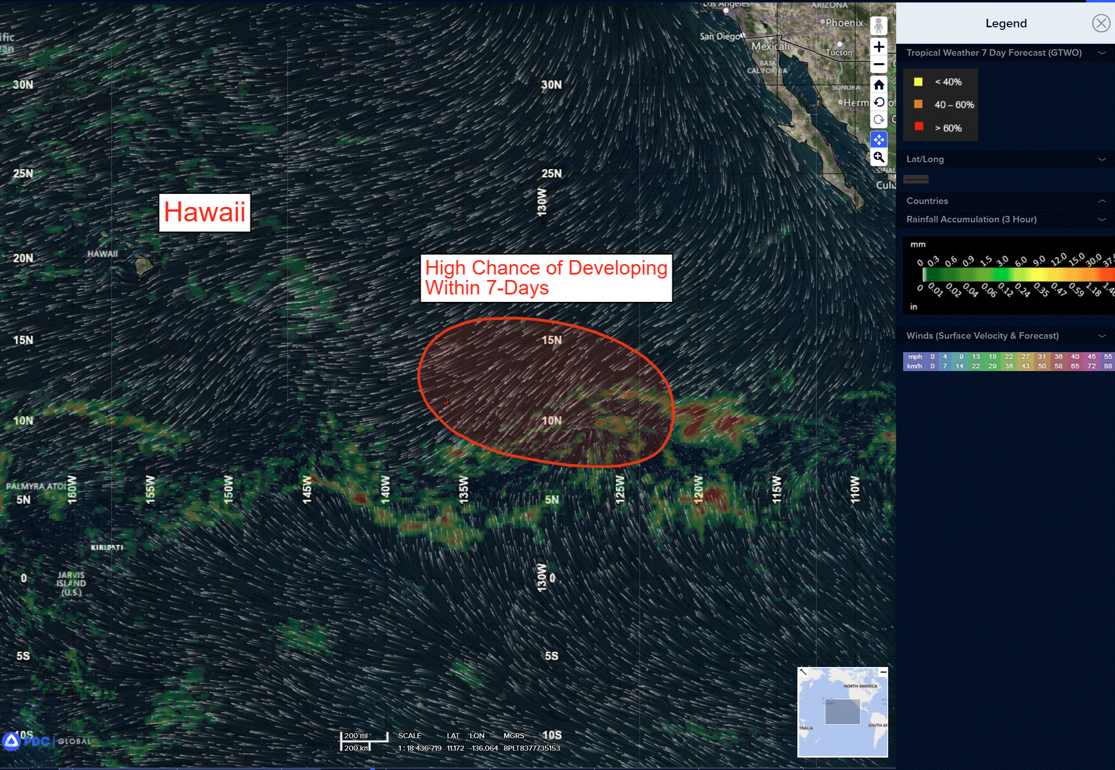
Well Southwest of the Baja California Peninsula:
A broad area of low pressure is forecast to form early next week well to the southwest of the southern tip of the Baja California peninsula.
Environmental conditions appear conducive for additional development thereafter, and a tropical depression is likely to form during the middle part of next week while moving westward or west-northwestward at 10 to 15 mph across the western portion of the East Pacific.
* Formation chance through 48 hours…low…near 0 percent
* Formation chance through 7 days…high…80 percent
Central Pacific Ocean: There are no Tropical Cyclones
Western Pacific, Indian Ocean, and adjacent Seas:
Western Pacific
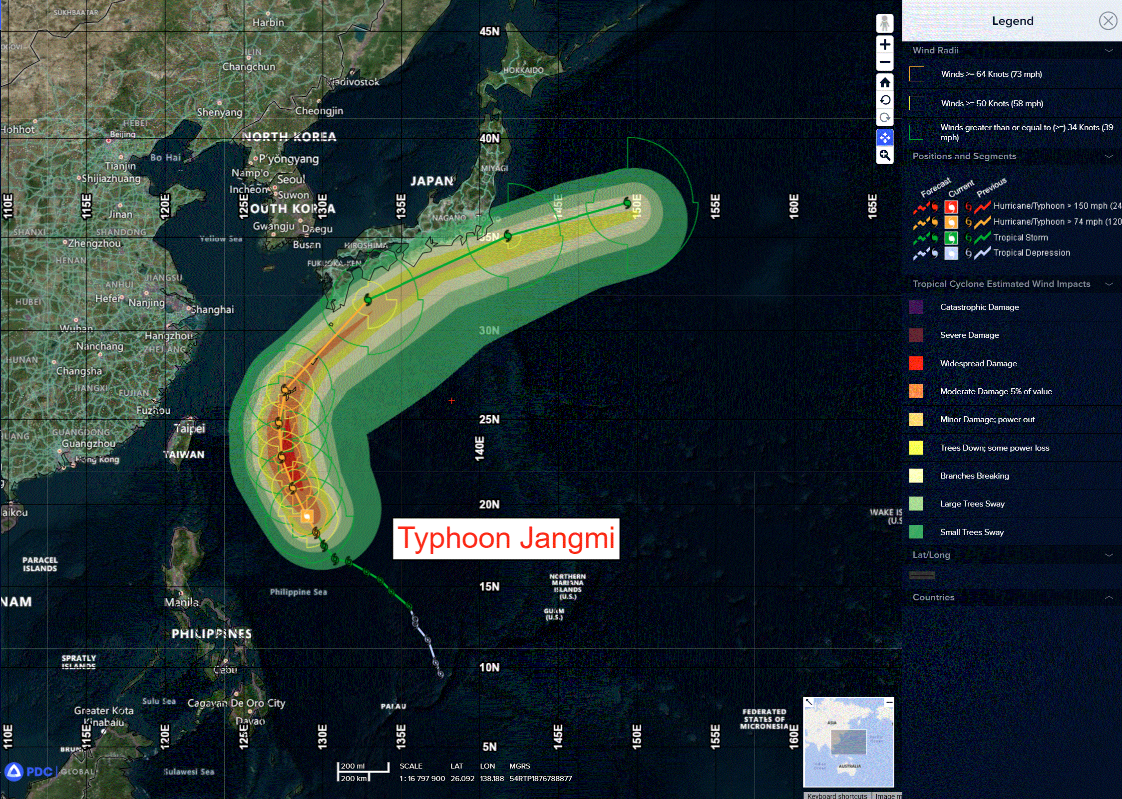
Tropical Cyclone 06W (Jangmi)
According to the JTWC warning number 15 sustained winds were 65 knots with gusts to near 80 knots
Typhoon 06W continues to display a broad, irregularly shaped, 65 NM wide eye in animated shortwave infrared (swir) imagery. Deep convection is confined to the southern and southeastern quadrants, while weak convective activity is present along the northern flank. The western eyewall is weak and currently devoid of significant convective activity. A 300929z rcm-3 sar pass revealed multiple mesovortices (at least five) along the inner edge of the eyewall, presenting a starfish-type orientation. A 301235z ascat pass provides a similar depiction, though the lower resolution reveals only three
mesovortices. Regardless, the inner-core of the system exhibits a highly irregular, high wave number structure, which is a primary factor in the lack of observable intensification over the last six hours. An upstream data outage has resulted in a loss of all microwave data since 0730z, which is adversely impacting both the position and intensity estimates.
Environmental conditions remain generally favorable; however, a mid-level layer of elevated westerly
shear is penetrating the eyewall from the west, entraining a wedge of dry air into the core of the system. Combined with the high-wave number asymmetries, and the generally expansive nature of the
core, the system is struggling to maintain its current structure and intensity.
Ttyphoon 06W has continued along its north-northwestward trajectory, moving along the southwestern flank of the strong str to the northeast centered near Iwo Tto. This general track motion is forecast to continue for the next 24 hours, before the system begins gradual deceleration as it approaches the str
axis just after 24 hours. By 36 hours, TY 06W will reach the ridge axis and slow to its minimum forward speed of less than 10 knots. The system makes its closest point of approach (cpa) to Okinawa by 48 hours, as it begins to turn northeastward and accelerate along the northwestern side of the str. From 48 to 96 hours, the system will steadily accelerate along the tight pressure gradient between the str
to the southeast and the westerlies to the north.
The system begins to decelerate once again after 96 hours, as the str retreats rapidly southward, reducing the strength of the steering gradient. The forecast tracks TY 06W just west of Okinawa by 48 hours, then parallels the northern Ryukyu Island chain before passing south of Kyushu, Shikoku, and Honshu through the forecast period. However, as the system treks northward, the wind field will expand, with impacts possible relatively distant from the storm’s center.
Regarding intensity, the latest frames of swir imagery provide indications that the asymmetries seen in the earlier sar data may be decreasing, and the system may be in the early phases of axisymmetrization. Without microwave data and high-resolution visible imagery, it is impossible to confirm definitively. However, mesoscale models have depicted gradual axisymmetrization over the next 24 hours, and it may currently be underway. Nevertheless, the expansive nature of the inner core, combined with the moderate westerly mid-level shear, and the limited time remaining (24-36 hrs) before TY 06W reaches cooler waters, will severely limit the degree of intensification.
The forecast calls for a peak intensity of 80 knots by tau 24, before the onset of steady weakening as the system passes over significantly cooler sea surface temperatures (ssts) and experiences increasing shear. TY 06W will begin extratropical transition (ett) just prior to 96, as the system approaches the Tokyo Bay region, and begins tointeract with a mid-latitude trough and a branch of the jet stream. Transition to an extratropical, strong-gale low-pressure system is expected no later than 120 hours.