
")
Current Snapshot
For all the latest updates visit: DisasterAWARE
GOES18-TPW-13-900×540
sinlaku
close
04W_110600sair

04W_tracks_latest
31p
himawari9_ir_31P_202604111320_lat-33.3-lon175.8
31P_tracks_latest
By PDC’s Senior Weather
Specialist Glenn James

The Pacific Disaster Center’s (PDC Global) Saturday, April 11, 2026, Tropical Cyclone Activity Report…for the Pacific Ocean, the Indian Ocean, and adjacent Seas
Current Tropical Cyclones:
Tropical Cyclone 04W (Sinlaku)…is located approximately 440 NM east-southeast of Navsta, Guam
Northeast Pacific Ocean: There are no Tropical Cyclones
The last regularly scheduled Tropical Cyclone Activity Report of the 2025 eastern North Pacific Hurricane Season has been issued. Routine issuance of this section of the PDC product will resume on May 15, 2026. During the off-season, Special Tropical Weather Outlooks will be issued as conditions warrant by the NHC.
Central Pacific Ocean: There are no Tropical Cyclones
The 2025 central North Pacific hurricane season has ended. As such, the final routine Tropical Cyclone Activity Report for the 2025 season has been issued. Routine issuance of this section of the PDC product will resume on June 1, 2026. During the off-season, Special Tropical Weather Outlooks will be issued as conditions warrant by the CPHC.
Western Pacific, Indian Ocean, and adjacent Seas:
Northwest Pacific Ocean
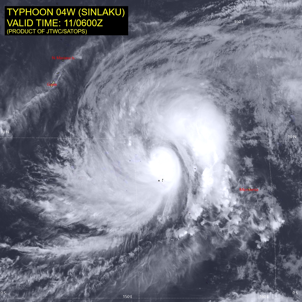
Tropical Cyclone 04W (Sinlaku)
According to the JTWC warning number 13, sustained winds are 80 knots with gusts to 100 knots
Animated multi-spectral satellite imagery (msi) depicts rapidly developing spiral bands of deep convection tightly wrapping into a fully obscured low-level circulation center of typhoon 04W (Sinlaku).
Analysis reveals highly favorable and supportive environment, characterized by warm (28-29 c) sea surface temperatures (sst), deep atmospheric moisture, low (5-10 kts) vertical wind shear and robust radial outflow. Exhaust mechanism is
further elevated by an upper-level centered to the northeast of the system, and a near-equatorial ridge (ner) positioned to the east.
While the steering mechanism is currently weak, resulting in very slow translational speeds, the ner centered to the southeast is expected to develop a northward propagating extension, eventually assuming primary steering. As a result, TY 04W is forecast to steadily pick up speed, while tracking generally northwestward towards the southern Mariana Islands.
With the environment remaining highly favorable for rapid intensification, TY Sinlaku is forecast to reach a peak of 125 kts around 48 hours, ahead of the final approach toward the island chain. Given the impressive wind field size, the 34 kt wind radii will be in reach of the Marianas between 36 and 48 hours. Around 72 hours, TY 04W is expected to begin its recurvature motion around the southwestern
periphery of the building extension of the ner. The system is expected to start weakening at that point, given slowly increasing vertical wind shear.
Southwest Pacific Ocean
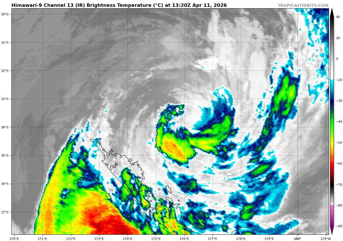
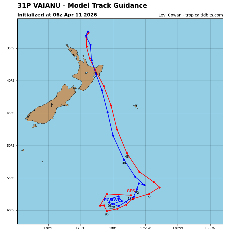
>>> There’s an area of disturbed weather being referred to as Invest 31P, which is located approximately 142 NM north-northeast of Auckland, NZ
The system is currently classified as a subtropical cyclone, generally characterized as having both tropical and mid-latitude cyclone features.
Animated enhanced infrared satellite imagery (msi) depicts a very well-defined low-level circulation center (llcc) embedded within a tight swirl of mid-level cloud bands, absent of any deep convection.
Environmental analysis reveals unfavorable conditions for development characterized by high vertical wind shear (20-30 knots), moderate upper level poleward outflow, and cold sea surface temperatures (23-24 c).
Global models agree on a southwestward track over the next 24-48 hours.
Maximum sustained surface winds are estimated at 33 to 38 knots.
The potential for the development of a significant tropical cyclone within the next 24 hours remains low.