
")
Current Snapshot
For all the latest updates visit: DisasterAWARE
epac
sinlaku
close

04W_141200sair
himawari9_ir_04W_202604141510_lat14.9-lon145.8
04W_tracks_latest
By PDC’s Senior Weather
Specialist Glenn James

The Pacific Disaster Center’s (PDC Global) Tuesday, April 14, 2026, Tropical Cyclone Activity Report…for the Pacific Ocean, the Indian Ocean, and adjacent Seas
Current Tropical Cyclones:
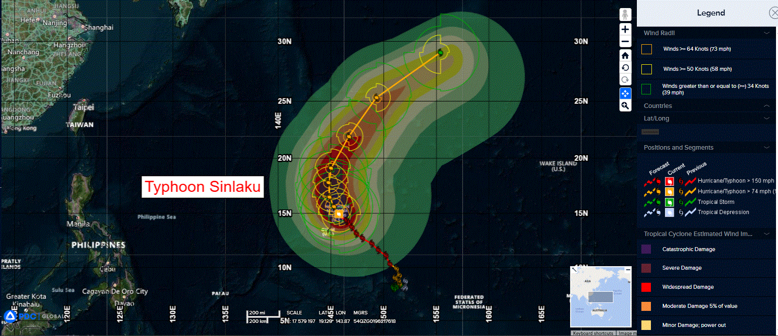
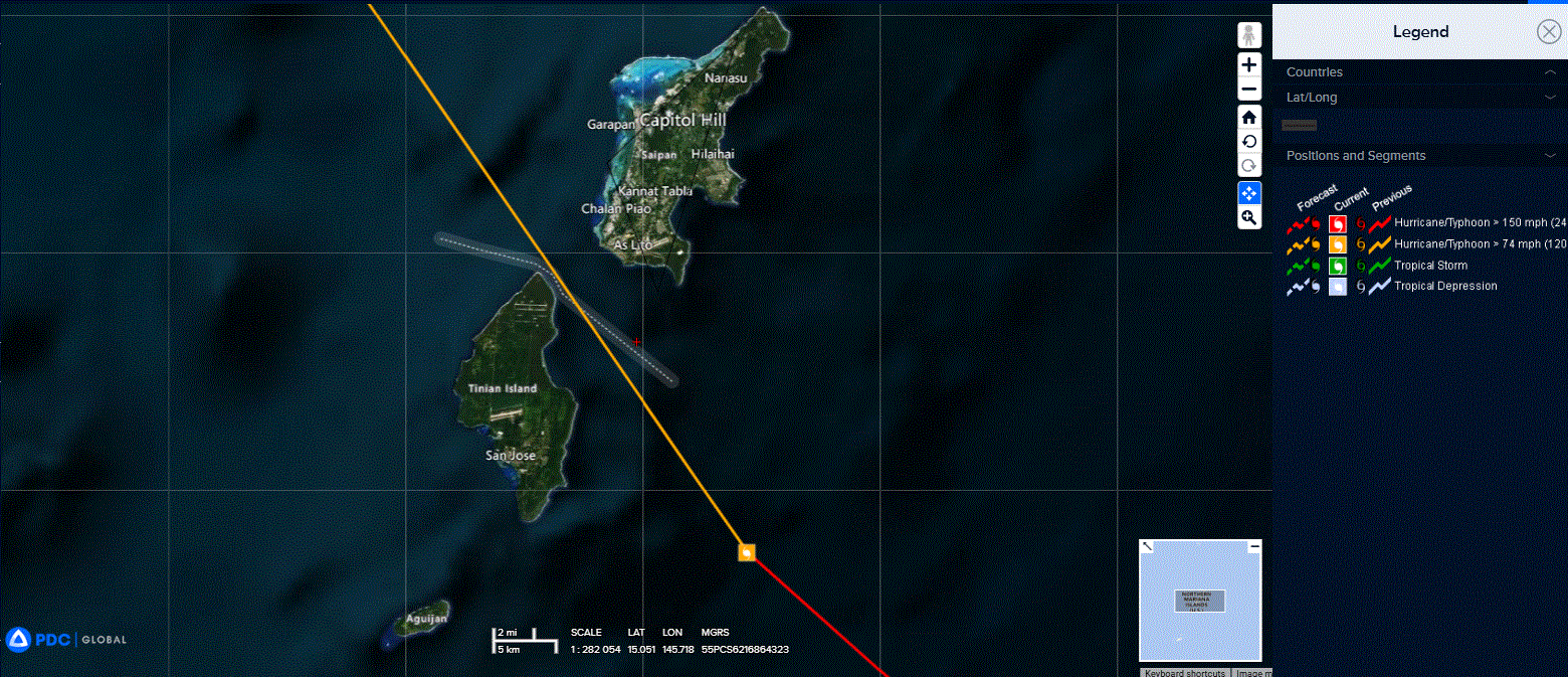
Tropical Cyclone 04W (Sinlaku)…is located approximately 23 NM west of Saipan
Northeast Pacific Ocean: There are no Tropical Cyclones
The last regularly scheduled Tropical Cyclone Activity Report of the 2025 eastern North Pacific Hurricane Season has been issued. Routine issuance of this section of the PDC product will resume on May 15, 2026. During the off-season, Special Tropical Weather Outlooks will be issued as conditions warrant by the NHC.
Central Pacific Ocean: There are no Tropical Cyclones
The 2025 central North Pacific hurricane season has ended. As such, the final routine Tropical Cyclone Activity Report for the 2025 season has been issued. Routine issuance of this section of the PDC product will resume on June 1, 2026. During the off-season, Special Tropical Weather Outlooks will be issued as conditions warrant by the CPHC.
Western Pacific, Indian Ocean, and adjacent Seas:
Northwest Pacific Ocean
Tropical Cyclone 04W (Sinlaku)
According to the JTWC warning number 24, sustained winds are 115 knots with gusts to 140 knots
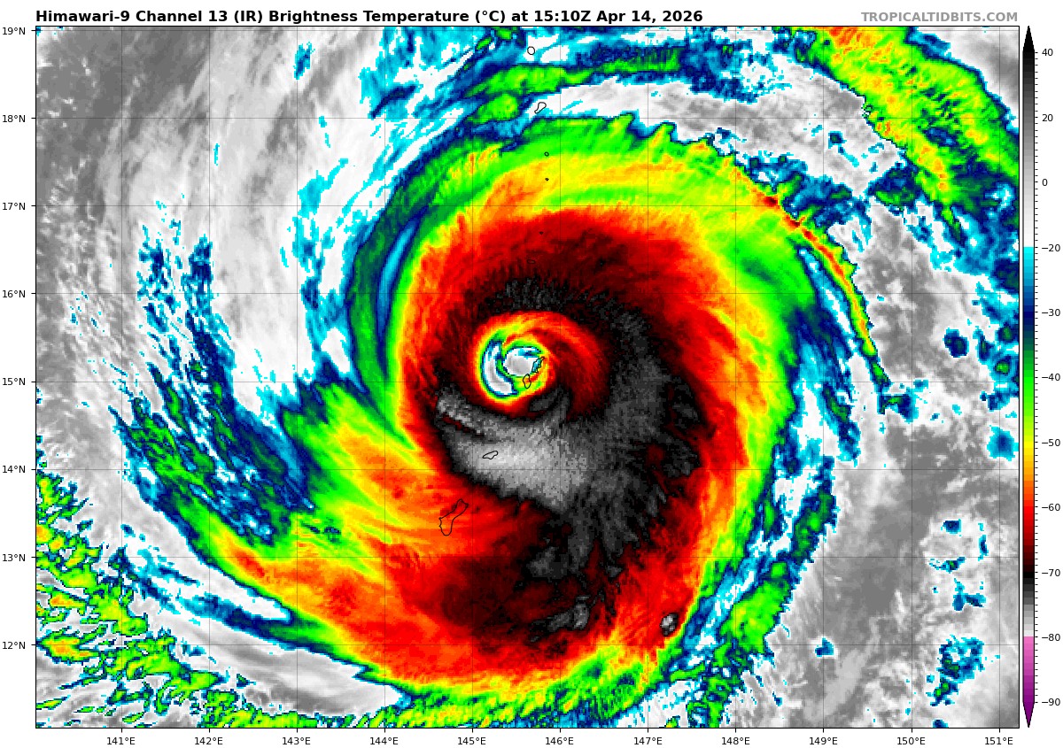
Animated enhanced infrared (eir) satellite imagery depicts a slowly weakening typhoon undergoing an eyewall replacement cycle (erc). While the central dense overcast (cdo) has become more ragged, the convection remains healthy, with cloud top temperatures as cold as -80 degrees celsius. The convection is now primarily wrapping around the outer eyewall with the inner eyewall eroding away, which is clearly showcased by a 140821z wsf-m mwi 89 ghz image.
The pgua radar confirms that the inner eyewall is shallowing out and opening up, enabling a gradual outward transfer of momentum to the consolidating outer eyewall. For 141200z, the radius of maximum wind will remain aligned with the inner eyewall, given that Saipan international airport is reporting even higher wind speeds inside the outer ring. In fact, the airport sensor reported a sustained wind of 71 kts and a gust of 113 kts at 141200z, and earlier metar returned a mean sea level pressure of 948.8 mb.
Environmental conditions are favorable with ample ocean heat content of near 150
kj cm2, abundant deep-layer moisture, and low vertical wind shear (vws), though the ongoing erc is leading to some weakening. The upper-level outflow remains robust in the western semi-circle but is somewhat restricted in the southeast quadrant.
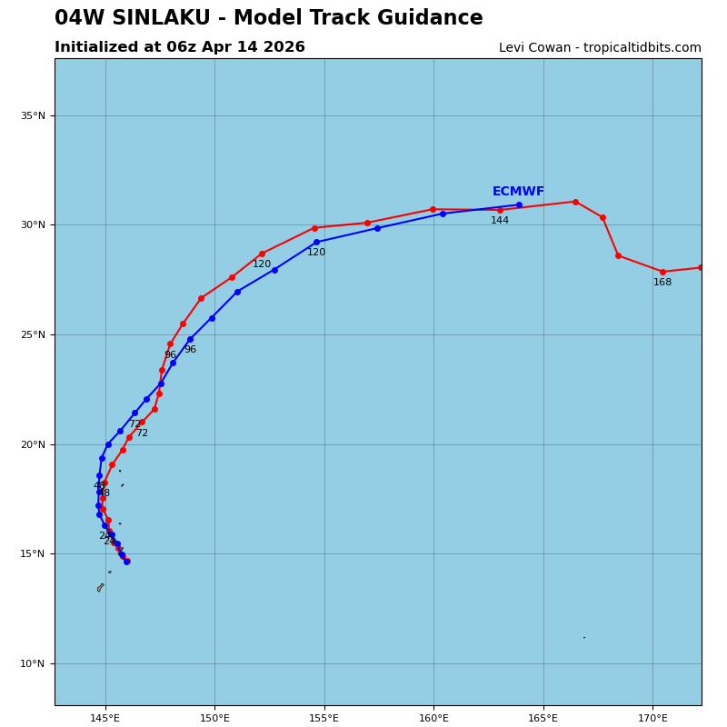
The forward speed of typhoon 04W has significantly slowed to 04 kts, prolonging the destructive conditions over the Mariana Islands. After a brief west-northwest motion, Sinlaku appears to have resumed its average trajectory towards the northwest, and the western eyewall has moved over Saipan and Tinian.
TY 04w will continue to slowly travel to the northwest under the steering influence of the building near to the east. As Sinlaku gains latitude and approaches a weakness in the subtropical ridge (str) to the north, it will begin round the str axis by 24 hours. A sharpening shortwave trough passing south of Honshu will briefly erode the str, allowing for a more northward to north-northeastward motion and a gradual increase in forward speed.
By 72, the system will become increasingly embedded in the westerlies poleward of the str axis, accelerate towards the northeast, and undergo extratropical transition (ett) as a storm-force low. The powerful typhoon continues to slowly weaken due to the erc. For the next 24 hours, environmental conditions will be conducive due to low vws, warm sea surface temperatures (sst), and ample mid-level moisture. If the system is able to quickly complete the erc, the intensity will hold, and slight intensification is not out of the question.
The forecast intensity reflects a scenario in which the erc will be slow to complete, and the initial rate of weakening will be slow. Environmental analysis depicts a vast region of dry air immediately west of the storm. Faster weakening will commence beyond 24 hours as TY 04W traverses over progressively cooler sst and enters a
drier, more stable environment with a significantly larger eye.