
")
Current Snapshot
For all the latest updates visit: DisasterAWARE
2
e
c
2222
07W_221200sair

07W_tracks_latest
08W_221200sair

08W_tracks_latest
By PDC’s Senior Weather
Specialist Glenn James

The Pacific Disaster Center’s (PDC Global) Monday, June 22, 2026, Tropical Cyclone Activity Report…for the Pacific Ocean, the Indian Ocean, and adjacent Seas
Current Tropical Cyclones:
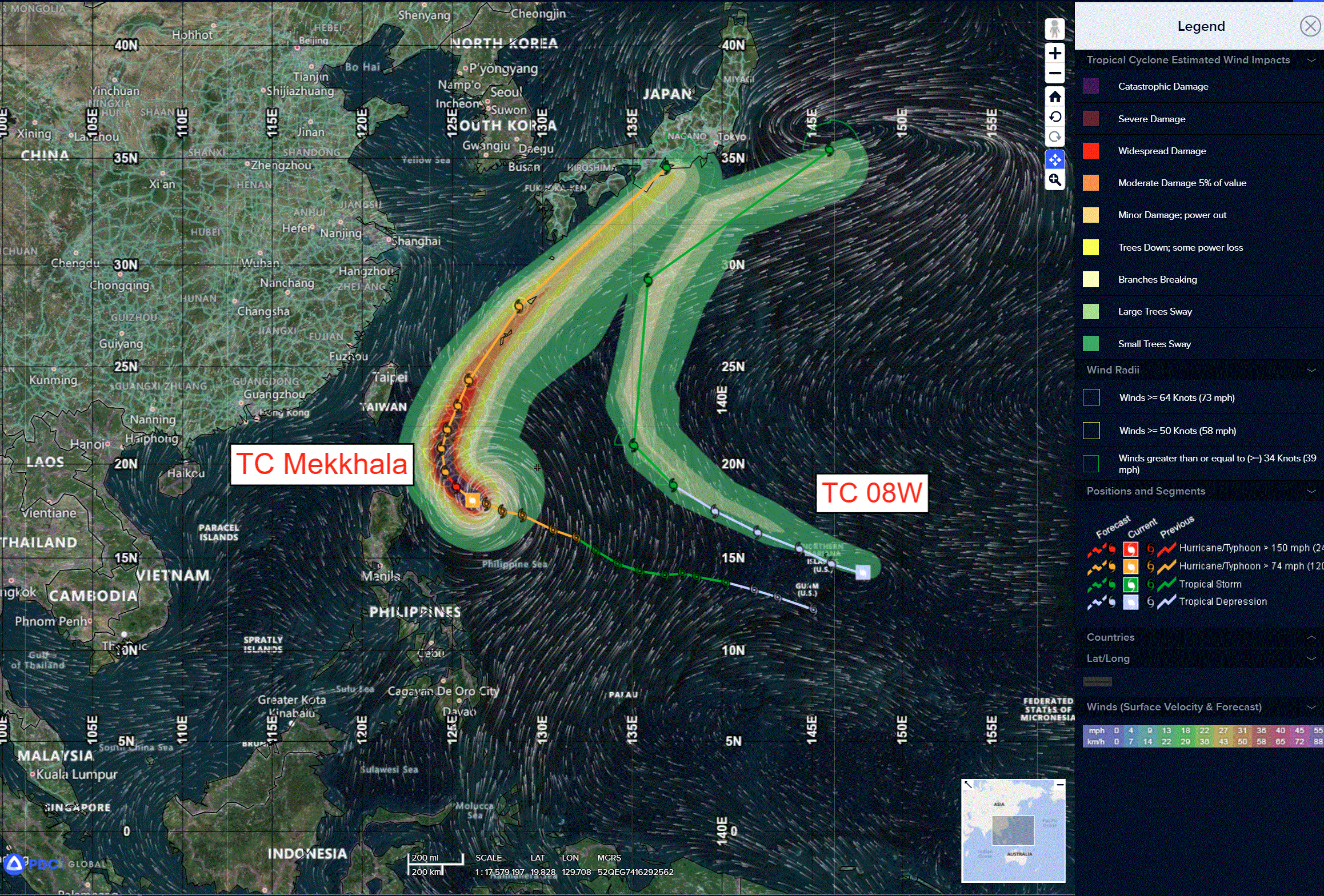
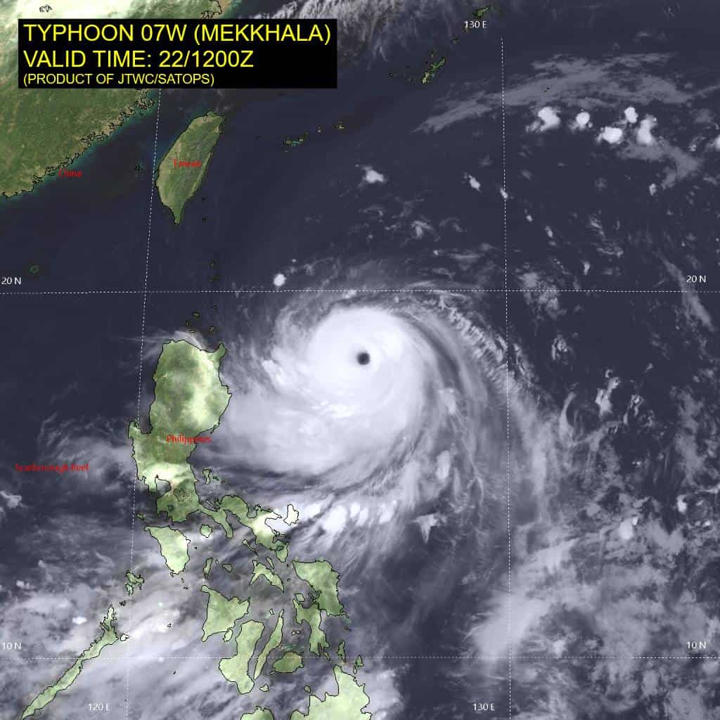
Tropical Cyclone 07W (Mekkhala)…is located 478 NM south-southwest of Kadena AB
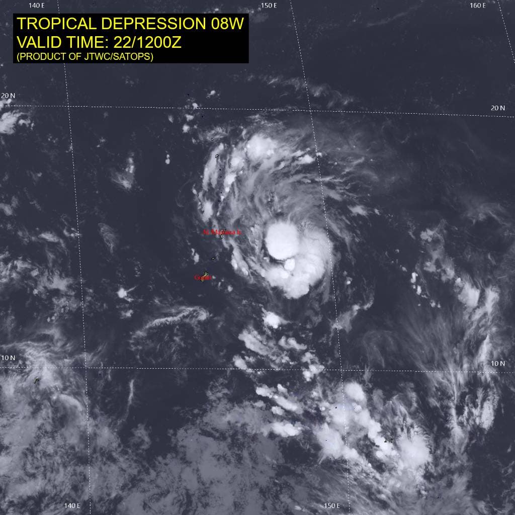
Tropical Cyclone 08W (Higos)…is located 18 NM south of Tinian
Northeast Pacific Ocean: There are no Tropical Cyclones
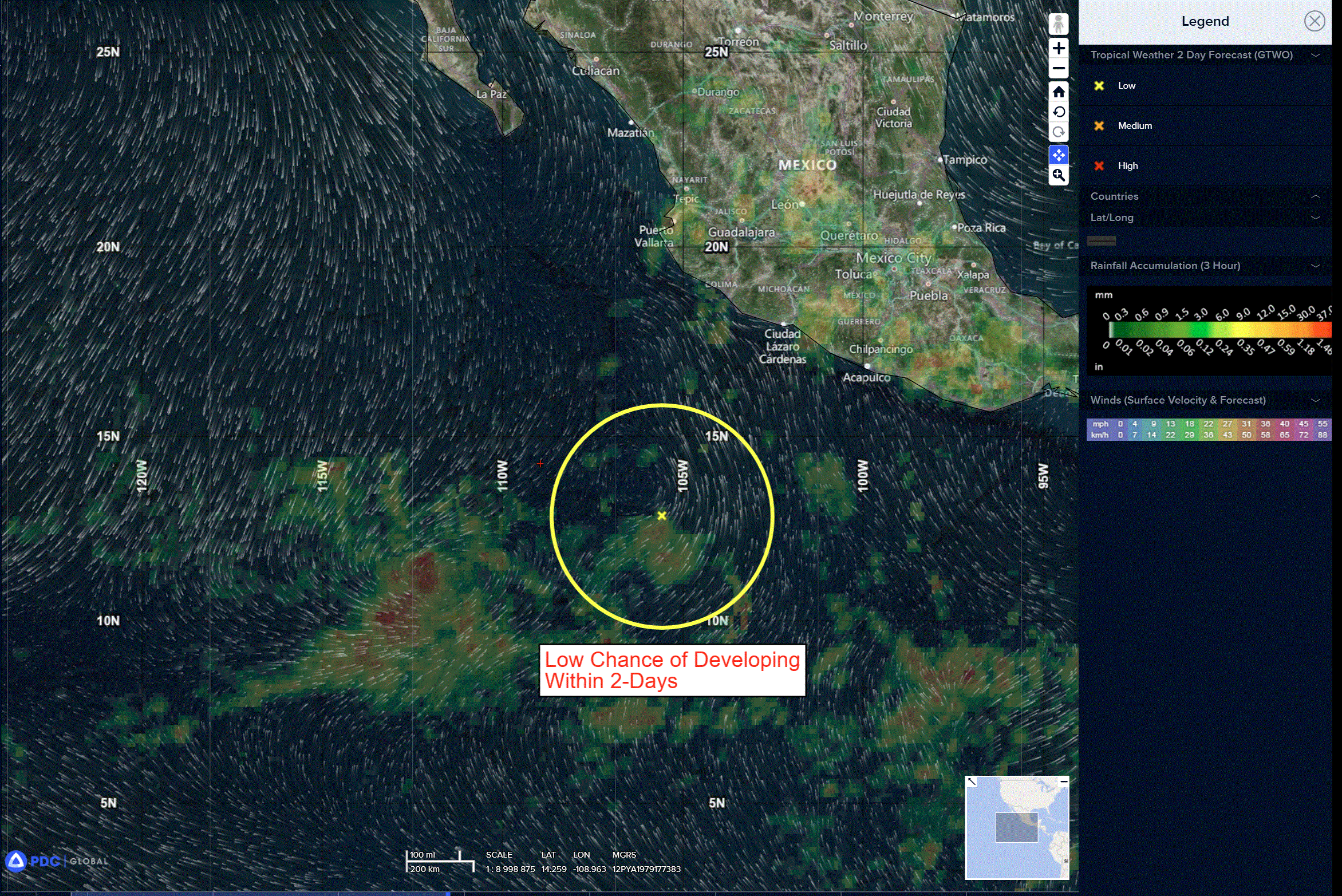
Central and Western Portion of the East Pacific:
Invest 94E
>>> A tropical wave located a few hundred miles south-southwest of the coast of southwestern Mexico continues to produce a large area of disorganized showers and thunderstorms. This disturbance is forecast to move westward to west-northwestward at 10 to 15 mph across the central portion of the East Pacific basin, and some development is possible during the next couple of days before it moves into unfavorable environmental conditions late this week.
* Formation chance through 48 hours…low…30 percent
* Formation chance through 7 days…low…30 percent
Well Offshore of Southwestern Mexico:
>>> A low pressure system is expected to form late this week several hundred miles offshore of the coast of southwestern Mexico. Some slow development of this system is possible after that time, and it could become a tropical depression this weekend or early next week while it moves west-northwestward at 10 to 15 mph.
* Formation chance through 48 hours…low…near 0 percent
* Formation chance through 7 days…medium…40 percent
Central Pacific Ocean: There are no Tropical Cyclones
Central and Western Portion of the East Pacific:
Invest 94E
>>> A tropical wave located a few hundred miles south-southwest of the coast of southwestern Mexico continues to produce a large area of disorganized showers and thunderstorms. This disturbance is forecast to move westward to west-northwestward at 10 to 15 mph across the central portion of the East Pacific basin, and some development is possible during the next couple of days before it moves into unfavorable environmental conditions late this week.
* Formation chance through 48 hours…low…30 percent
* Formation chance through 7 days…low…30 percent
Western Pacific, Indian Ocean, and adjacent Seas:
Western Pacific
Tropical Cyclone 07W (Mekkhala)
According to the JTWC Warning number 18…sustained winds are 115 knots with gusts to 140
Animated enhanced infrared (eir) satellite imagery depicts typhoon 07W (Mekkhala) with a well-defined and symmetrical eye approximately 17 NM in diameter with a central eye temperature of 15c. 07W has continued to rapidly develop, intensifying 50 kts in 24 hours and 70 kts in the past 36 hours.
Environmental analysis reveals highly favorable conditions characterized by low to moderate (15-20 kts) vertical wind shear (vws), warm (29-30 c) sea surface temperatures (sst), and robust radial outflow.
TY 07W is forecast to continue tracking north-northwest for the next 12 hours while it remains on the southwestern edge of the extension from a steering str. Between 12-24 hours, the ridge extension is expected to weaken and retreat eastward, causing 07w to track into a weakness in the ridge. Mekkhala is expected to slow its speed of advance while rounding the extension, crossing the ridge axis no later than 24 hours. After
rounding the ridge axis, Mekkhala is forecast to track northeastward through the end of the forecast period.
At around 120 hours, 07W will begin to interact with the baroclinic zone and the polar front jet, inducing extratropical transition. 07W is expected to complete extratropical transition beyond the forecast period.
Regarding intensity, 07W is forecast to slightly slow its current rate of intensification and reach its peak intensity at 12 hours at 130 kts. A peak higher than 130 kts is possible at 24 hours if 07W continues to rapidly intensify at the current rate of intensification. As 07W turns north while rounding the ridge extension, it will encounter a hostile environment characterized by high (35-40 kts) vws and very dry air, with the possibility for further weakening induced by the storm’s cold wake. Mekkhala is expected to steadily weaken as it tracks farther poleward into the
highly unfavorable environment.
Western Pacific
Tropical Cyclone 08W (Higos)
According to the JTWC Warning number 3…sustained winds are 35 knots with gusts to 45
Animated enhanced infrared (eir) satellite imagery depicts tropical depression 08W as a slowly consolidating low-level circulation center (llcc) with persistent building deep convection over the center. Weak low-level cloud banding is present in animated eir, but the llcc is obscured by more vigorous mid-level rotation. The 221147z metop-c ascat pass revealed a closed surface circulation with 25-30 kt wind barbs in the northeastern quadrant.
Environmental analysis shows a marginally favorable area for development with low (5-10 kts) vertical wind shear, warm (29-30 c) sea surface temperatures (sst), offset by dry air and weak poleward outflow aloft.
TD 08W is forecast to track northwestward while under the influence of the steering str to its north. Around 60 hours, the ridge will retreat eastward, allowing 08W to recurve around the western periphery of the ridge. The system is expected to round the ridge axis between 72-96 hours and track northeastward through 120 hours.
Regarding intensity, 08W is forecast to intensify very gradually for the duration of the forecast period, reaching a peak intensity between 60-72 hours.
The environment is expected to remain marginal to marginally favorable through 120 hours, with dry air being the biggest inhibitor to development. If 08W is able to cocoon itself away from the dry environment, it may be able to intensify beyond the forecast 40 kt peak.