
")
Current Snapshot
For all the latest updates visit: DisasterAWARE
2
GOES19-EEP-13-900×540
goes19_ir_02E_202606081515_lat15.9-lon-99.2
boris

02E_tracks_latest
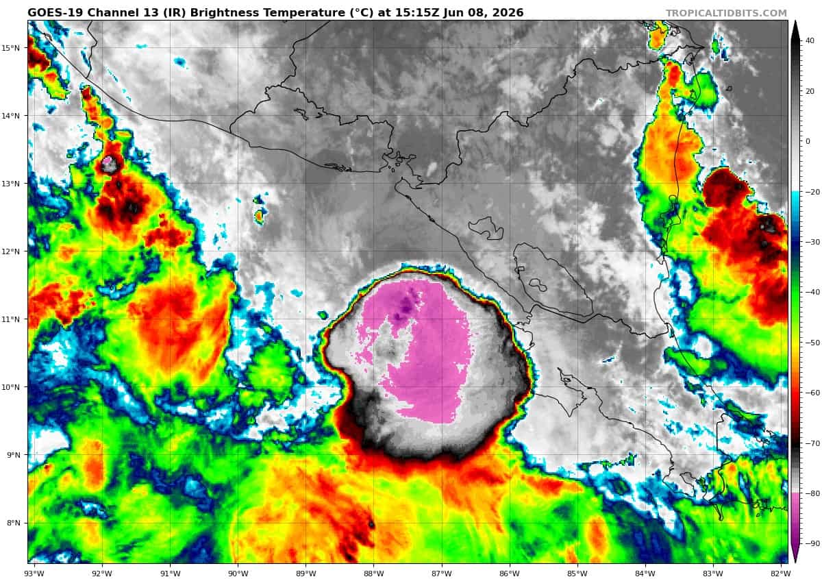
goes19_ir_03E_202606081515_lat11.2-lon-87.5

03E_tracks_latest
m
10
By PDC’s Senior Weather
Specialist Glenn James

The Pacific Disaster Center’s (PDC Global) Monday, June 8, 2026, Tropical Cyclone Activity Report…for the Pacific Ocean, the Indian Ocean, and adjacent Seas
Current Tropical Cyclones:
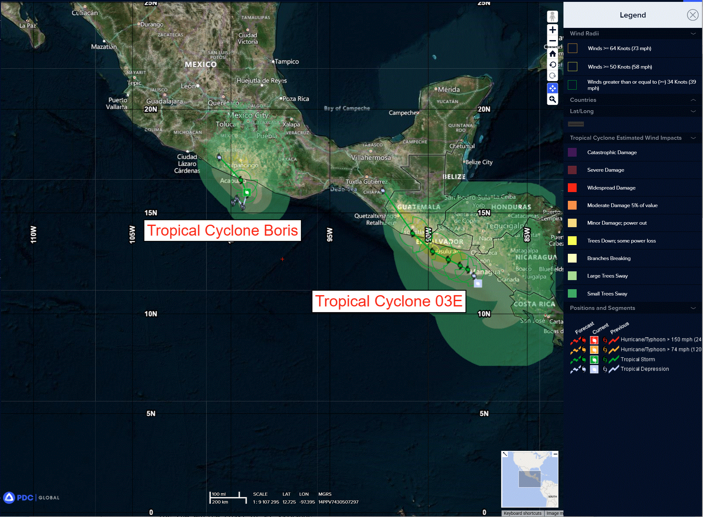
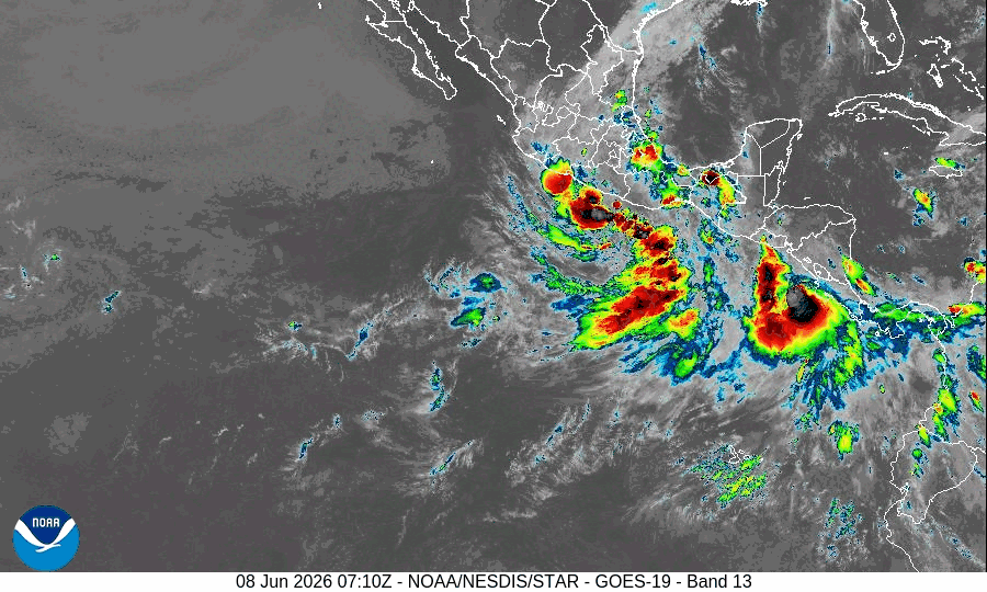
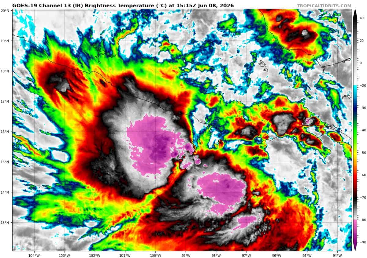
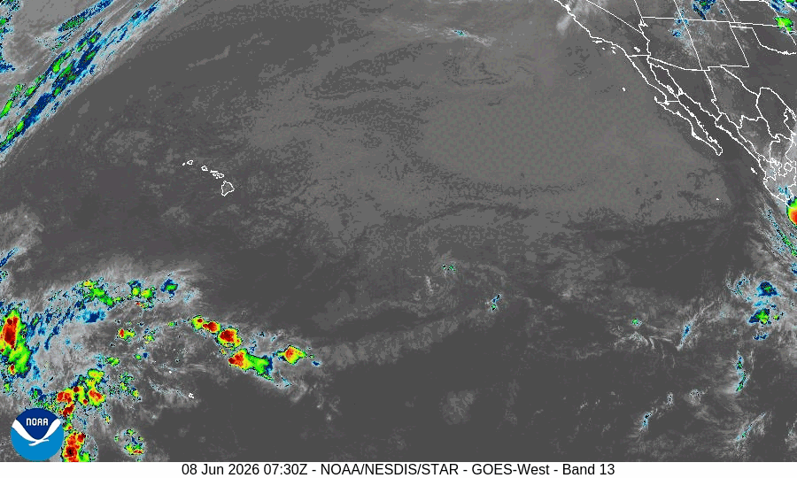
Tropical Cyclone 02E (Boris)…is located about 125 miles east-southeast of Acapulco, Mexico
Tropical Cyclone 03E (Cristina)…is located about 105 miles west-northwest of Managua, Nicaragua
Northeast Pacific Ocean:
Tropical Cyclone 02E (Boris)
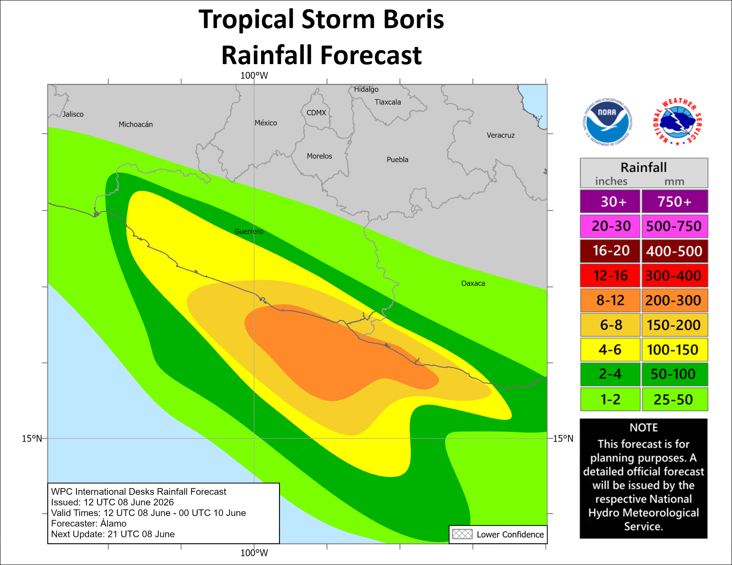
BORIS CLOSING IN ON THE SOUTHERN MEXICAN COASTLINE…LIKELY TO PRODUCE LIFE-THREATENING FLASH FLOODING THROUGH TUESDAY
According to the NHC advisory number 8
Boris is moving toward the north near 2 mph (4 km/h), and a turn toward the northwest and an increase in forward speed is expected overnight. On the forecast track, the center of Boris should reach the coast of Oaxaca and Guerrero, Mexico, late tonight into Tuesday morning. Maximum sustained winds are near 45 mph (75 km/h) with higher gusts. Little change in strength is forecast until landfall. Rapid weakening will occur after the center crosses the coast of southern Mexico. Tropical-storm-force winds extend outward up to 60 miles (95 km) from the center.
HAZARDS AFFECTING LAND
RAINFALL: Boris is expected to produce additional rainfall totals of 3 to 6 inches, with maximum totals of 8 inches possible across coastal portions of the Mexican states of Guerrero and Oaxaca through Tuesday. This rainfall may produce life-threatening flooding and mudslides, especially in areas of steep terrain.
WIND: Tropical storm conditions are likely occurring along the coast in the warning area and will continue into early Tuesday.
Tropical Cyclone 03E (Cristina)
CRISTINA SLOWS TO A CRAWL JUST OFF THE COAST OF CENTRAL AMERICA…HEAVY RAINFALL EXPECTED OVER THE NEXT FEW DAYS WITH COASTAL FLOODING POSSIBLE IN AREAS OF ONSHORE WIND
According to the NHC advisory number 4
Cristina is moving slowly toward the north near 2 mph (4 km/h), and a slow meandering motion is forecast for the next day or so followed by a slow northwestward motion. On the forecast track, Cristina should move near or along the coast of Nicaragua, Honduras and El Salvador over the next couple of days. Maximum sustained winds are near 45 mph (75 km/h) with higher gusts. Little change is strength is forecast over the next day or two. Tropical-storm-force winds extend outward up to 70 miles (110 km) from the center.
HAZARDS AFFECTING LAND
RAINFALL: Cristina is expected to produce rainfall totals of 4 to 8 inches, with maximum totals of 12 inches possible across coastal portions of Nicaragua, Honduras, El Salvador, and Guatemala through Thursday morning. This rainfall may produce life-threatening flooding and mudslides, especially in areas of steep terrain.
STORM SURGE: Coastal flooding from storm surge is possible in the areas of onshore winds. Near the coast, the surge will be accompanied by large and damaging waves.
WIND: Tropical storm conditions are expected to begin along the coast within the warning area tonight into Tuesday.
Central Pacific Ocean: There are no Tropical Cyclones
Tropical cyclone formation is not expected during the next 7 days.
Western Pacific, Indian Ocean, and adjacent Seas: There are no Tropical Cyclones