
")
Current Snapshot
For all the latest updates visit: DisasterAWARE
ch
bbbbb
GOES18-TPW-13-900×540
jan

06W_281200sair

06W_tracks_latest
By PDC’s Senior Weather
Specialist Glenn James

The Pacific Disaster Center’s (PDC Global) Thursday, May 28, 2026, Tropical Cyclone Activity Report…for the Pacific Ocean, the Indian Ocean, and adjacent Seas
Current Tropical Cyclones:
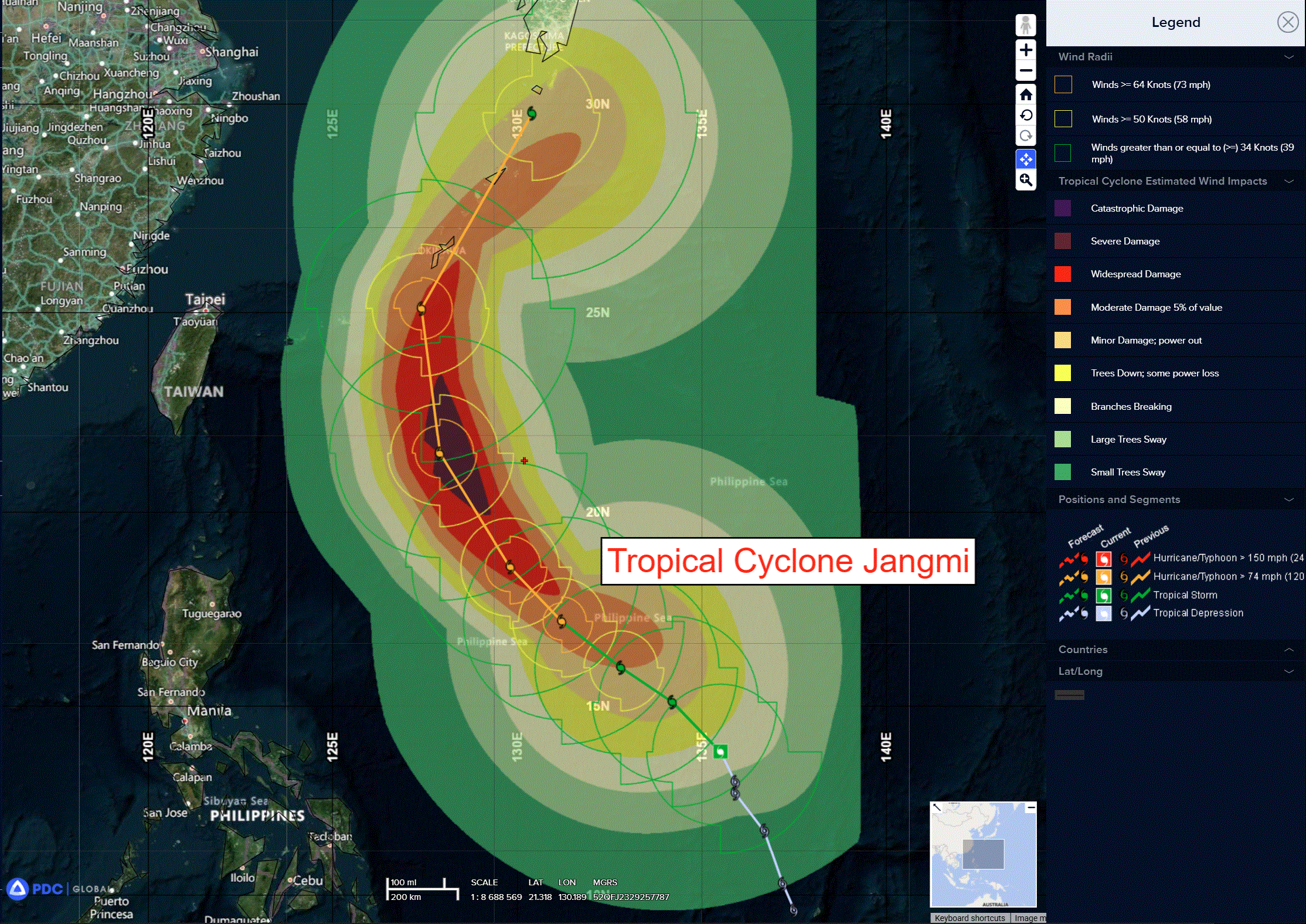
Tropical Cyclone 06W (Jangmi)…is located approximately 743 NM south-southeast of Kadena AB
Northeast Pacific Ocean: There are no Tropical Cyclones
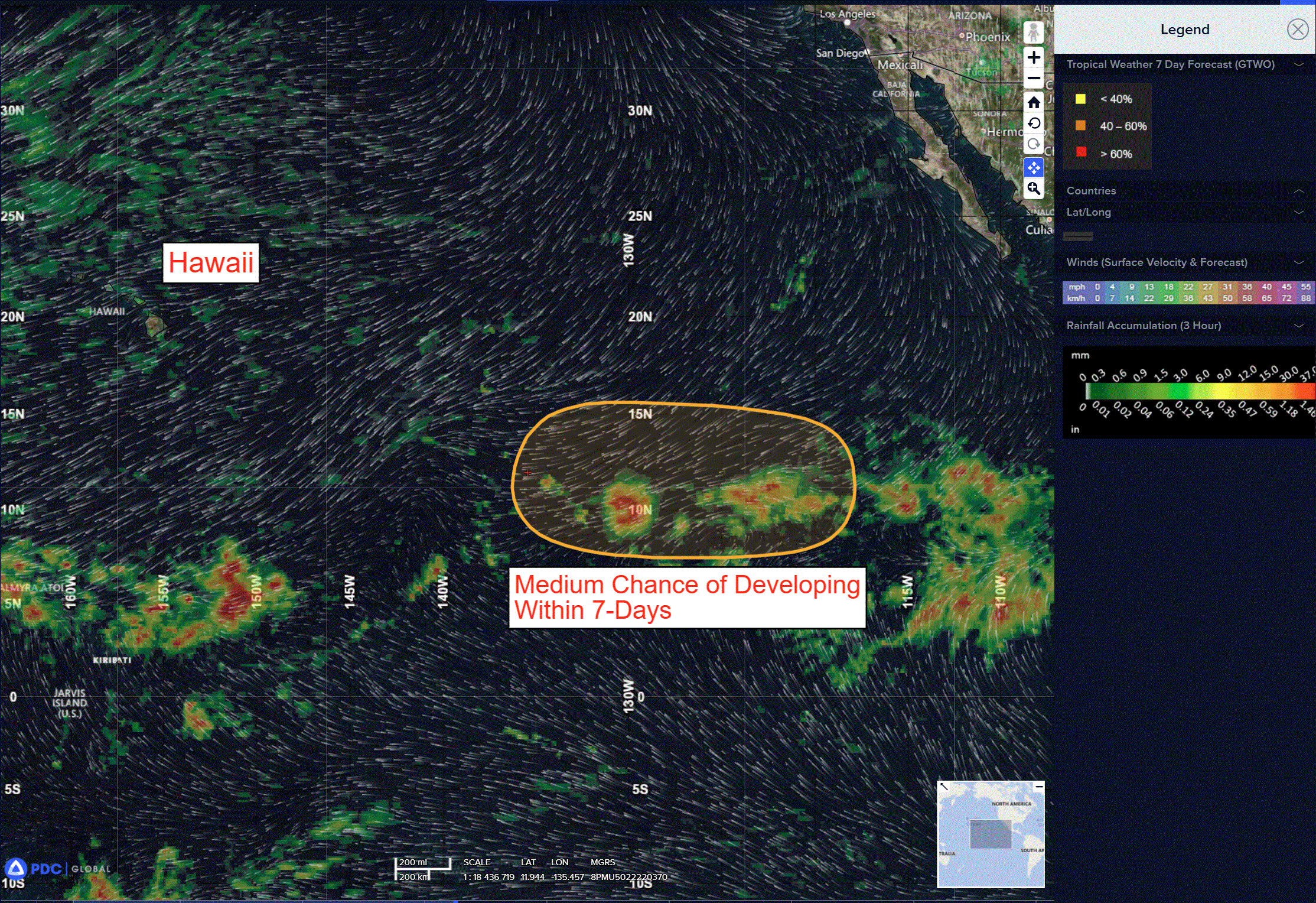
Well Southwest of the Baja California Peninsula:
A broad area of low pressure is forecast to form early next week well to the southwest of the southern tip of the Baja California peninsula.
Some gradual development of this system is possible thereafter, and a tropical depression could form during the middle part of next week while it moves westward or west-northwestward at 10 to 15 mph across the western portion of the East Pacific.
* Formation chance through 48 hours…low…near 0 percent.
* Formation chance through 7 days…medium…50 percent.
Central Pacific Ocean: There are no Tropical Cyclones
Western Pacific, Indian Ocean, and adjacent Seas: There are no Tropical Cyclones
Western Pacific
Tropical Cyclone 06W (Jangmi)
According to the JTWC warning number 8 sustained winds were 40 knots with gusts to near 50 knots
A diagnosis of the synoptic environment reveals favorable conditions for continuous development of tropical storm 06W (Jangmi), characterized by moderate equatorward and poleward outflow, a deeply moist tropospheric column, low (10-15 kts) vertical wind shear, and elevated oceanic heat content coincident with sea surface temperatures of 29-30 c.
Animated enhanced infrared (eir) satellite imagery depicts TS Jangmi as it continues to consolidate. The system has recently picked up speed as the low-to-mid level subtropical ridge (str) to the northeast continues to build. The vortex core remains somewhat broad as evidenced by recent scatterometry data – a 281136z metop-b and a 281206z metop-c ascat pass.
Tropical storm 06W is anticipated to propagate on a generally north-northwestward heading, steered by the peripheral influence of a weak subtropical ridge centered to the northeast. As this anticyclone amplifies and becomes the dominant steering mechanism, TS Jangmi will advance toward the ridge axis, facilitating continued consolidation and intensification.
A steady deepening is projected, culminating in a peak intensity of 95 kts near 72 hours. Beyond this peak, the evolving synoptic pattern will force a recurvature, inducing a poleward and eastward turn by 96 hours. During this latter portion of the forecast, the system will commence a weakening phase as it encounters a more hostile
environmental regime, highlighted by rapidly cooling sea surface
temperatures and a slight increase in vertical wind shear.
As TS 06W transits the Ryukyu Archipelago near Kadena, reduced oceanic heat content will enhance the probability of cold water upwelling, exacerbating the rate of decay. By 120 hours, as the system
approaches Kyushu, a pronounced enhancement in poleward outflow
divergence will be negated by deteriorating sea surface temperatures plummeting to 24-25 c, ultimately resulting in a rapid weakening trend.