
")
Current Snapshot
For all the latest updates visit: DisasterAWARE
nnnnnnn
jang
06W_280000sair

06W_tracks_latest
By PDC’s Senior Weather
Specialist Glenn James

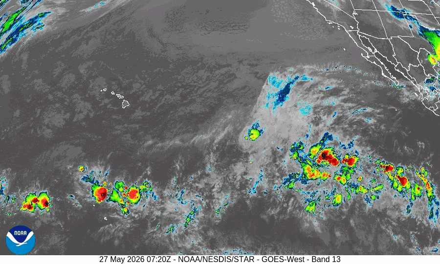
The Pacific Disaster Center’s (PDC Global) Wednesday, May 27, 2026, Tropical Cyclone Activity Report…for the Pacific Ocean, the Indian Ocean, and adjacent Seas
Current Tropical Cyclones:
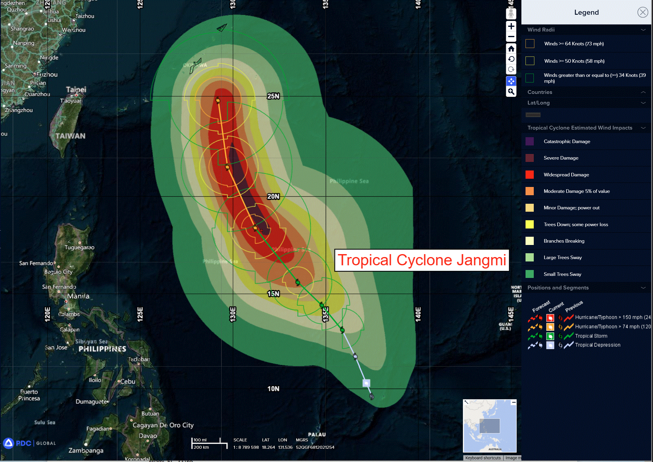
Tropical Cyclone 06W (Jangmi)…is located approximately 232 NM northwest of Yap
Northeast Pacific Ocean: There are no Tropical Cyclones
Tropical cyclone formation is not expected during the next 7 days.
Central Pacific Ocean: There are no Tropical Cyclones
Western Pacific, Indian Ocean, and adjacent Seas: There are no Tropical Cyclones
Western Pacific
Tropical Cyclone 06W (Jangmi)
According to the JTWC warning number 4 sustained winds were 30 knots with gusts to near 40 knots
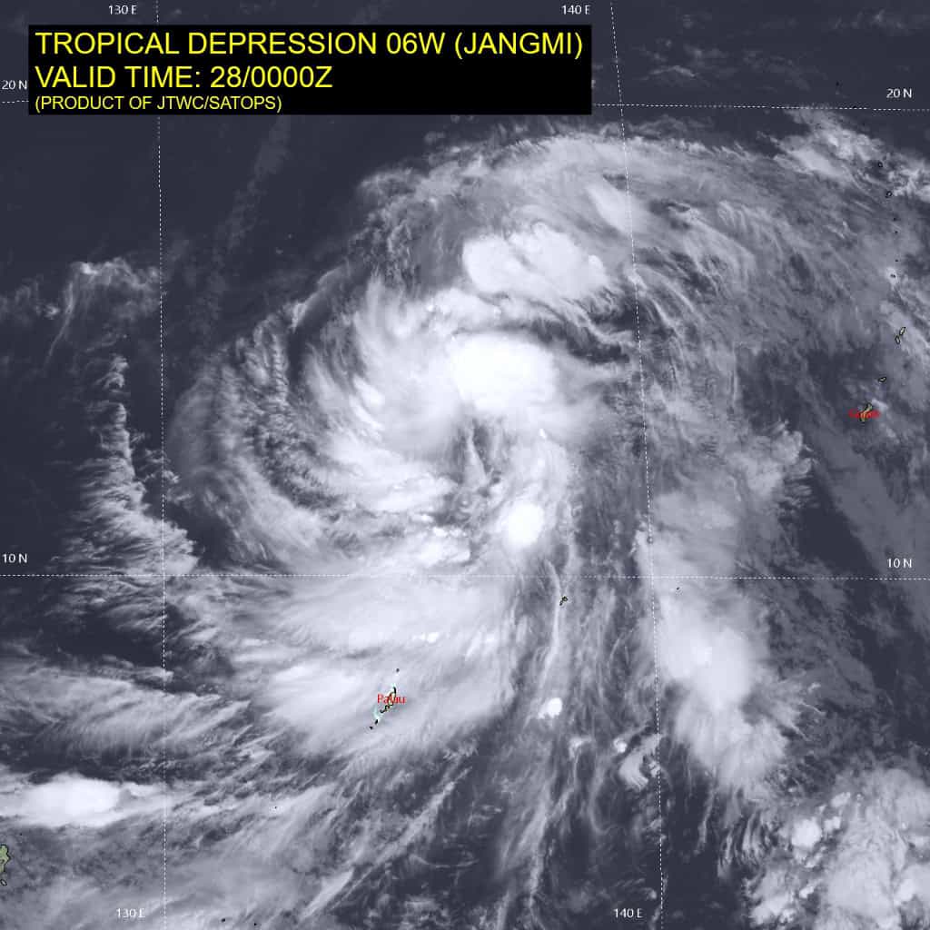
Tropical depression 06W (Jangmi) continues to present as a broad, asymmetric system with an ill-defined low-level circulation center (llcc). Deep convective cells continue to flare intermittently, primarily restricted to the western semicircle of the circulation. The convective suppression along the eastern flank is attributable to mid-level dry air as indicated by the Yap 1200z sounding, which depicted two distinct layers of subsided dry air in the mid-levels, as well as south-southwesterly winds of 60-70 knots between 600-450mb.
In comparison with the sounding, the hwrf appears to be the only model initializing the vertical wind profile accurately. So, while the low-level vortex is ill-defined, broad and relatively weak, the mid-level vortex is much stronger, particularly on the eastern side, which is generating strong relative vorticity, helping to align and consolidate the vortex. A recent scatterometer pass revealed the llcc to be northwest of Yap and provided medium confidence in the initial position.
The initial intensity is maintained at 25 knots with medium confidence, based on a blend of the subjective and objective intensity estimates noted below, validated by the scatterometer data which indicated maximum, non-flagged winds of 25 knots.
Environmental conditions continue to be favorable, characterized by warm sea surface temperatures (ssts), low deep-layer vertical wind shear (vws), and moderate poleward and equatorward outflow aloft, offset by dry mid-level air intrusion along the eastern flank, the broad nature of the llcc, and the vertically tilted vortex.
North-northwestward along the western boundary of a low- to mid-level
subtropical ridge (str) centered to the south of Guam. As TD 06W continues to intensify, the str will build and expand northward in response, developing into a north-south oriented ridge with an axis along the Marianas Island chain. By 36 hours, the str to the east is forecast to reorient to a more northwest-southeast axis and continues to build, while a second str over southeastern China recedes westward, inducing a weakness in the steering pattern in the vicinity of Okinawa.
TD 06W will turn onto a northwestward trajectory from 36 to 72 hours, driven along the western flank of the str to the east and towards the orographically assisted weakness in the ridging pattern. By 72 hours, a mid-latitude trough will move eastward across Korea, deepening the weakness in the ridge near Okinawa while simultaneously shifting the str further east. This will allow TD 06W to begin to recurve, approaching the ridge axis by 120 hours. The primary driver of track variance during this phase of the forecast is the timing and amplitude of the trough passage.
The ecmwf depicts a stronger, deeper trough, which results in accelerated recurvature and track speed after 96 hours. Conversely, the gfs depicts a weaker trough, with a resulting slower track that delays recurvature by approximately 12 hours and extends further west, resulting in a direct impact on Okinawa.
Regarding intensity, the system remains disorganized with a vertically misaligned vortex. The mesoscale models suggest it will take 24-36 hours for the vortex to achieve vertical alignment. During this window, the system is expected to intensify at the climatological rate of one t-number per day, forecast to reach 35 knots in 24 hours. Then after 36 hours, the system will intensify more rapidly, with rapid intensification (ri) explicitly forecast between 48 and 72 hours, as the system passes
over warm, high ocean heat content (ohc) waters.
After 72 hours, the system will begin moving over a tongue of cool ssts east of Okinawa, which accompanied by a marginal increase in shear will result in a general weakening trend after 96 hours as the system approaches cpa to Okinawa. At the same time however, the wind radii are forecast to expand significantly after 96 hours, particularly on the north and western periphery.