
")
Current Snapshot
For all the latest updates visit: DisasterAWARE
GOES18-TPW-13-900×540
hagupit
05W_061200sair
himawari9_ir_05W_202605061520_lat7.1-lon145.7
05W_tracks_latest
By PDC’s Senior Weather
Specialist Glenn James

The Pacific Disaster Center’s (PDC Global) Wednesday, May 6, 2026, Tropical Cyclone Activity Report…for the Pacific Ocean, the Indian Ocean, and adjacent Seas
Current Tropical Cyclones:
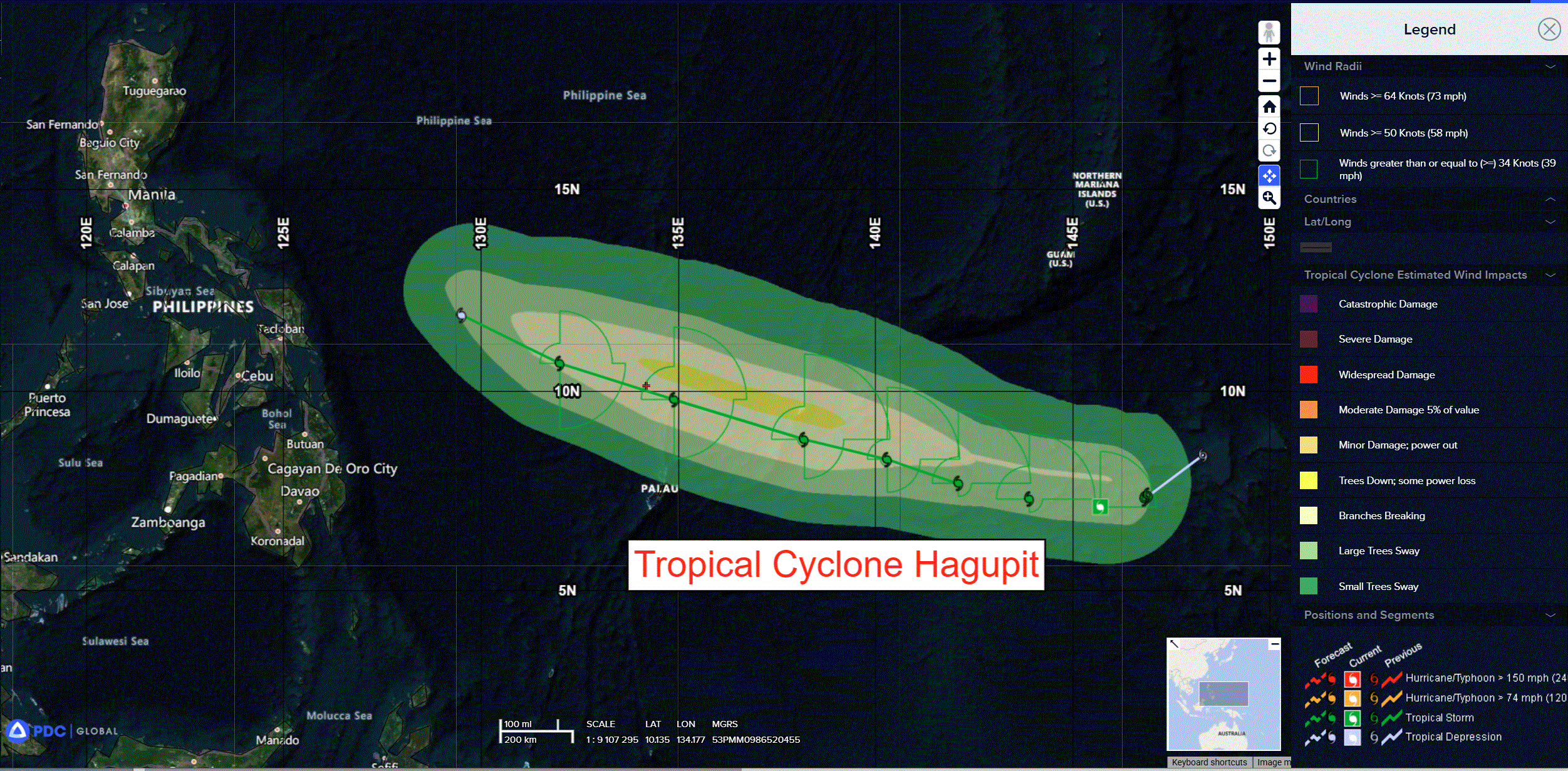
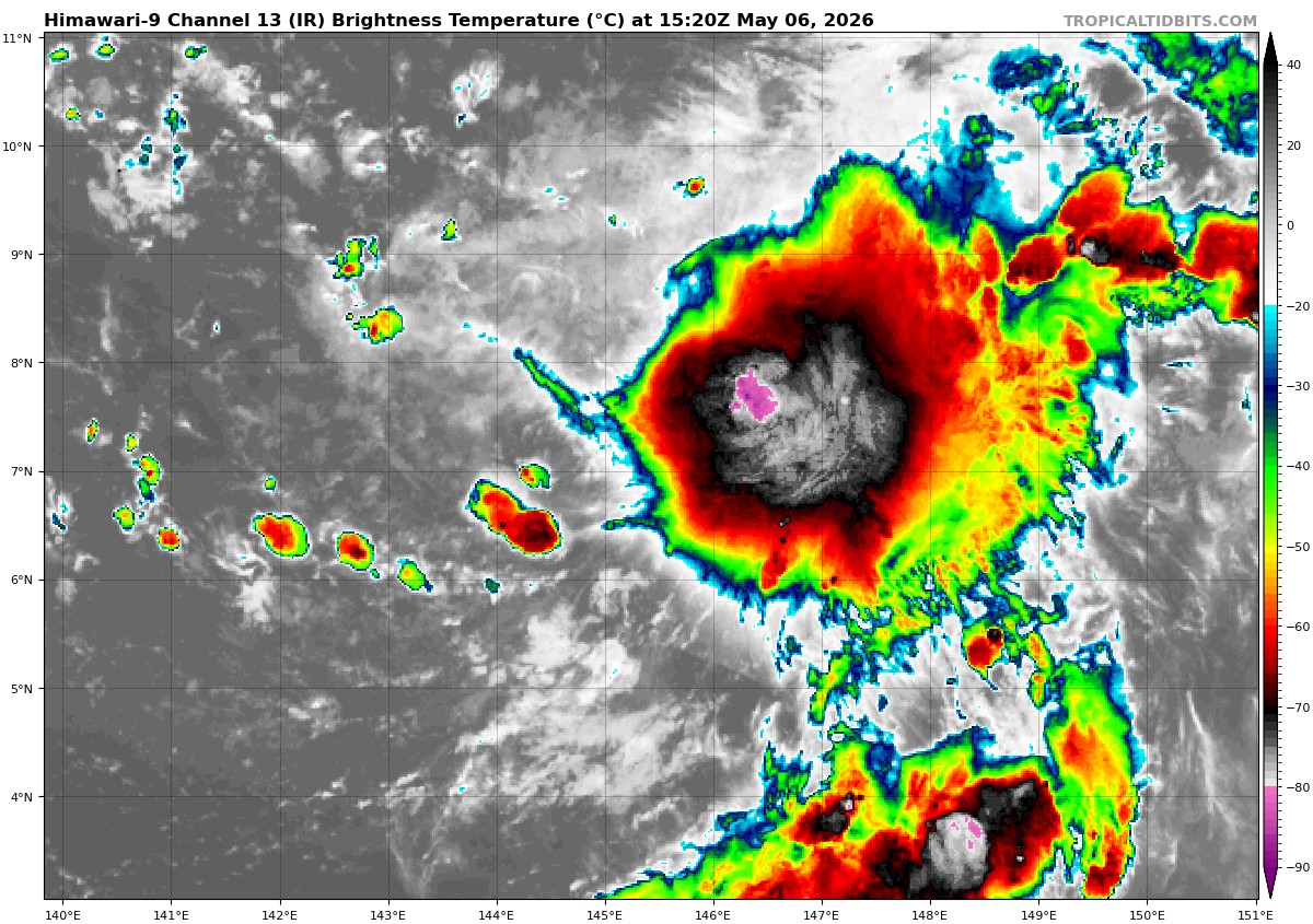
Tropical Cyclone 05W (Hagupit) is located approximately 365 NM east-southeast of Yap
Northeast Pacific Ocean: There are no Tropical Cyclones
The last regularly scheduled Tropical Cyclone Activity Report of the 2025 eastern North Pacific Hurricane Season has been issued. Routine issuance of this section of the PDC product will resume on May 15, 2026. During the off-season, Special Tropical Weather Outlooks will be issued as conditions warrant by the NHC.
Central Pacific Ocean: There are no Tropical Cyclones
The 2025 central North Pacific hurricane season has ended. As such, the final routine Tropical Cyclone Activity Report for the 2025 season has been issued. Routine issuance of this section of the PDC product will resume on June 1, 2026. During the off-season, Special Tropical Weather Outlooks will be issued as conditions warrant by the CPHC.
Western Pacific, Indian Ocean, and adjacent Seas:
Tropical Cyclone 05W (Hagupit)
According to the JTWC Warning number 6, sustained winds are 35 knots with gusts to 45 knots
Animated multi-spectral satellite imagery (msi) depicts tropical storm 05W as an elongated and partially exposed low level circulation center (llcc). The 061119z ascat pass reveals 05W is embedded in a region of extended troughing with the highest wind speeds confined to the northeastern quadrant. The ascat data also
indicates that the persistent deep convection present in animated eir is caused by surface convergence, rather than a developed circulation under the convection.
Environmental analysis reveals a marginal environment characterized by moderate to high (15-20 kts) mid-level vertical wind shear and dry air entrainment, offset by moderate poleward outflow and warm (29-30 c) sea surface temperatures.
TS 05W (Hagupit) is anticipated to begin tracking westward to west-northwestward within the next 12 hours, as the shortwave trough to the north weakens and reorients the steering str. as a result of the str shifting eastward, 05W will track northwestward from tau 12-120.
Regarding intensity, 05W is forecast to remain around 35 kts through 24 hours, before intensifying slightly and peaking around 45kts between 48-72 hours. The storm is contending with a relatively dry surrounding environment, with the moderate vertical wind shear forcing dry air into the core, stifling development.
Hagupit’s saving grace for intensification is expected to be a slightly more favorable outflow channel created by the passing shortwave trough between 48-72 hours. Following 72 hours, Hagupit will begin its terminal weakening caused by the increasing mid-level vertical wind shear and dry air entrainment. Dissipation is expected no later than 120 hours.
There’s an area of disturbed weather being referred to as Invest 93S, which is located approximately 641 east of Diego Garcia
Animated enhanced infrared satellite imagery (eir) depicts a broad rotation with persistent but disorganized convection associated with the low level
circulation (llcc) embedded within a trough.
Environmental analysis depicts favorable conditions for development with low to moderate vertical wind shear (15-20 kts), warm sea surface temperatures (29-30c), and moderate poleward outflow within the upper levels.
Model guidance is mixed, with the gefs and ecens esembles depicting slow but steady devleopment as the system tracks poleward. Global deterministic
models are in a disagreement, with the gfs being the most aggressive guidance, depicting a rapid development and intensification within the next 72 hours, while the ecmwf and navgem show very weak development, keeping the system below warning threshold.
Maximum sustained surface winds are estimated at 18 to 23 knots.
The potential for the development of a significant tropical cyclone within the next 24 hours is low.