
")
Current Snapshot
For all the latest updates visit: DisasterAWARE
vvv
sin
close
04W_120600sair

04W_tracks_latest
By PDC’s Senior Weather
Specialist Glenn James

The Pacific Disaster Center’s (PDC Global) Sunday, April 12, 2026, Tropical Cyclone Activity Report…for the Pacific Ocean, the Indian Ocean, and adjacent Seas
Current Tropical Cyclones:
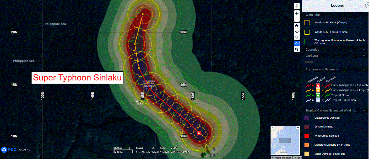
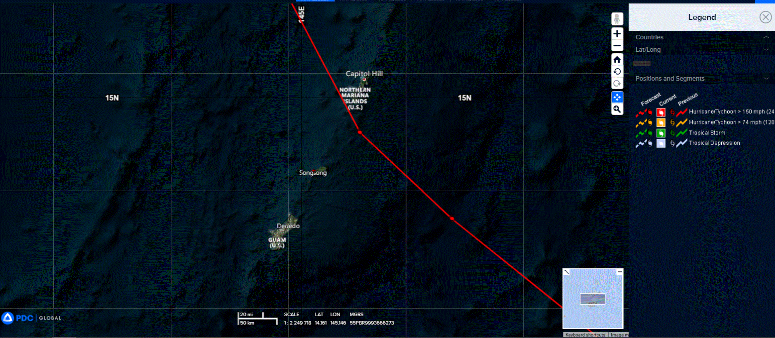
Tropical Cyclone 04W (Sinlaku)…is located approximately 307 NM east-southeast of Navsta, Guam
Northeast Pacific Ocean: There are no Tropical Cyclones
The last regularly scheduled Tropical Cyclone Activity Report of the 2025 eastern North Pacific Hurricane Season has been issued. Routine issuance of this section of the PDC product will resume on May 15, 2026. During the off-season, Special Tropical Weather Outlooks will be issued as conditions warrant by the NHC.
Central Pacific Ocean: There are no Tropical Cyclones
The 2025 central North Pacific hurricane season has ended. As such, the final routine Tropical Cyclone Activity Report for the 2025 season has been issued. Routine issuance of this section of the PDC product will resume on June 1, 2026. During the off-season, Special Tropical Weather Outlooks will be issued as conditions warrant by the CPHC.
Western Pacific, Indian Ocean, and adjacent Seas:
Northwest Pacific Ocean
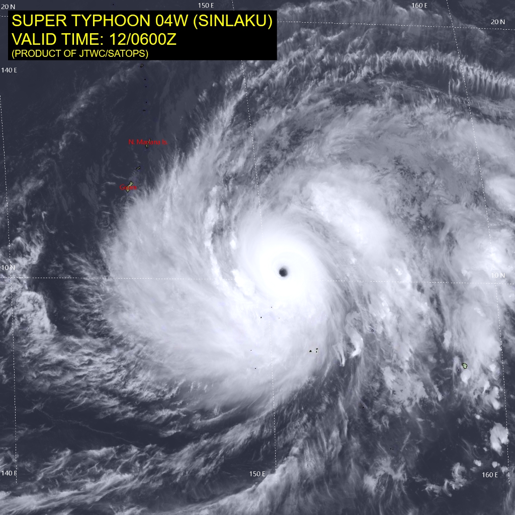
Tropical Cyclone 04W (Sinlaku)
According to the JTWC warning number 16, sustained winds are 155 knots with gusts to 190 knots
A comprehensive diagnosis of the synoptic environment reveals an exceptionally conducive regime for intensification, characterized by low (5-10 kts) vertical wind shear (vws), a deeply moist tropospheric column, and warm (28-29 c) sea surface temperatures (sst). Furthermore, a robust, efficient radial outflow structure is being augmented by an upper-level trough, with the axis centered to the northeast and a near-equatorial ridge to the southeast.
Animated multi-spectral satellite imagery (msi) depicts the morphological response to these conditions, with super typhoon 04W (Sinlaku) achieving a near-perfect symmetry of the central eye feature. surrounding the 20 NM diameter eye, similarly a cohesive central dense overcast (cdo) is observed. Continuous rapid intensification (ri) is therefore witnessed by adding the eye temperature increasing to 16 c to the overall assessment.
The persistence of a highly favorable atmospheric and oceanic regime is expected to fuel another brief period of rapid intensification, with a projected peak intensity of
140-145 kts within the next 24 hours. This intense phase will occur as STY 04W accelerates on a generally northwestward trajectory, a motion driven by the anticipated development of a northward extension of the near-equatorial ridge, which is expected to eventually become the primary steering mechanism.
Due to the expansive nature of the wind field, gale-force winds are expected to impact the Mariana islands shortly after 24 hours. while the system is currently forecast to reach its peak intensity prior to 24 hours, the weakening trend afterwards is predicted to be gradual, as the majority of the environmental parameters will remain highly favorable.
Global model guidance indicates that the increased distance from the upper-level trough to the northeast providing the supercharged outflow avenue at the moment will result in slightly decreased levels of 200 mb divergence. Around 72 hours, the system will begin its recurvature around the southwestern periphery of the building ridge to the east and will encounter a modest increase in vertical wind shear, as well as dry air entrainment, contributing to a steadier weakening.