
")
Current Snapshot
For all the latest updates visit: DisasterAWARE
GOES18-TPW-13-900×540
maila
30P_081200sair
30P_tracks_latest
v
31P_080600sair

31P_tracks_latest
By PDC’s Senior Weather
Specialist Glenn James

The Pacific Disaster Center’s (PDC Global) Wednesday, April 8, 2026, Tropical Cyclone Activity Report…for the Pacific Ocean, the Indian Ocean, and adjacent Seas
Current Tropical Cyclones:
Tropical Cyclone 04W…is located approximately 73 NM north of Chuuk
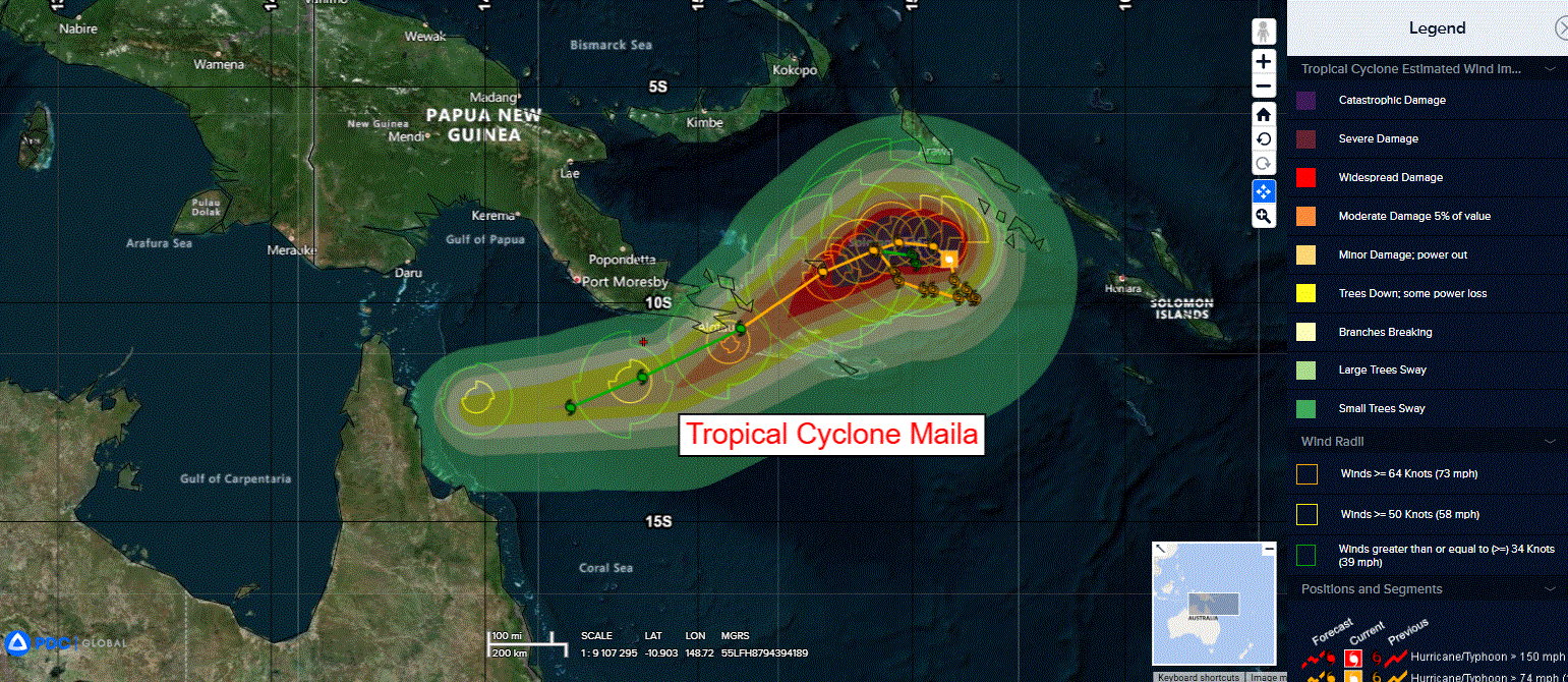
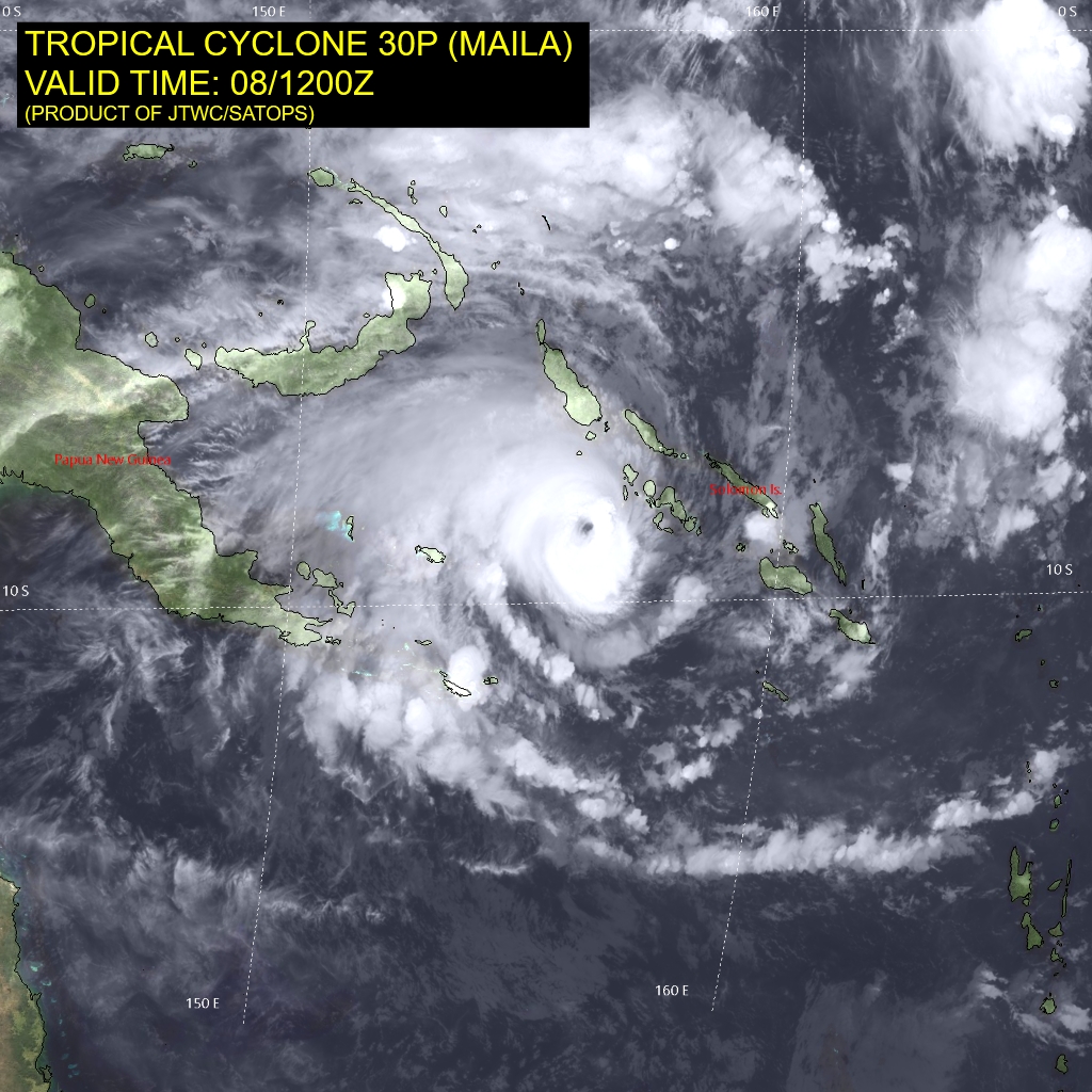
Tropical Cyclone 30P (Maila)…is located approximately 757 NM northeast of Cairns, Australia
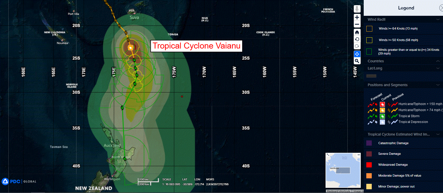
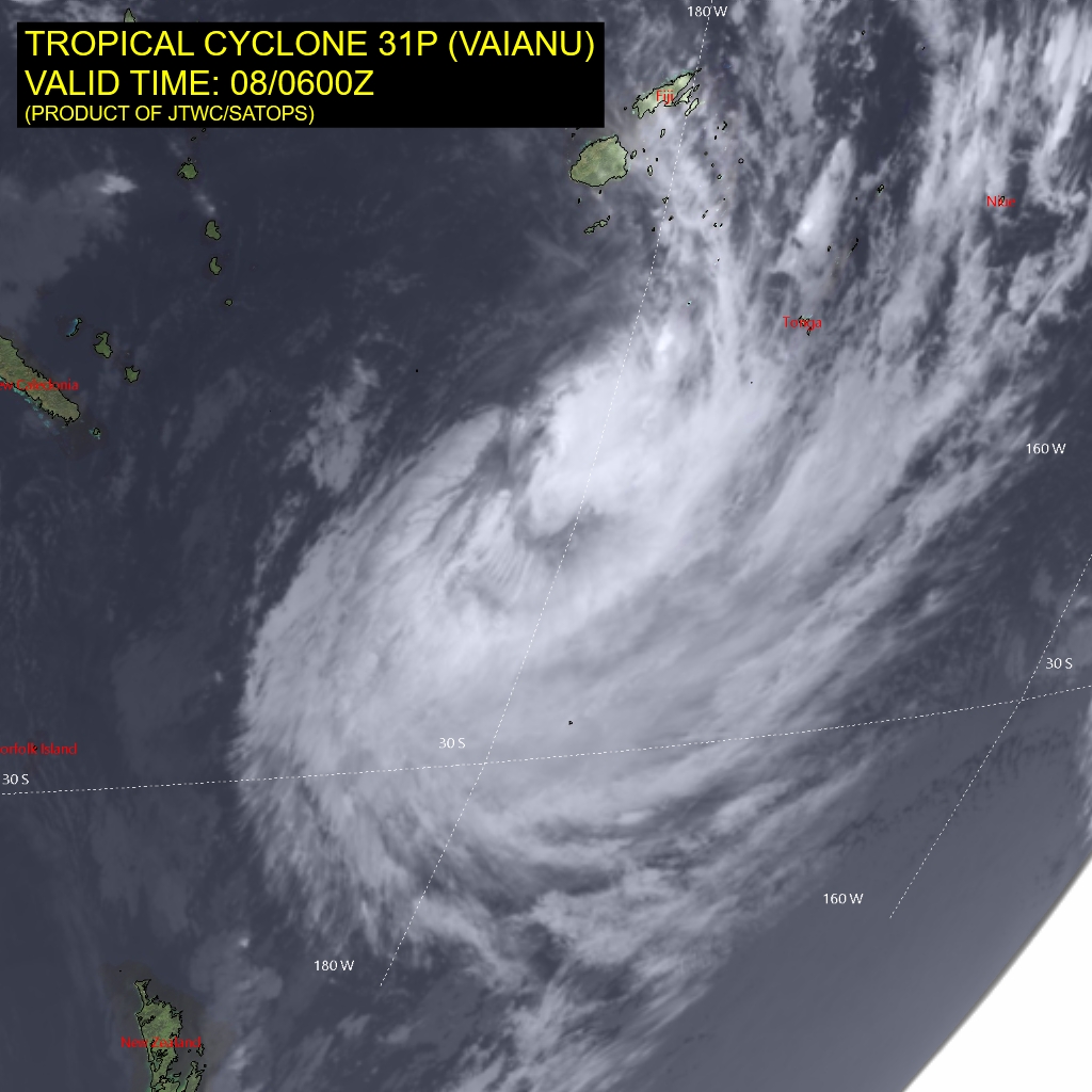
Tropical Cyclone 31P (Vaianu)…is located approximately 1079 NM north of Wellington, New Zealand
Northeast Pacific Ocean: There are no Tropical Cyclones
The last regularly scheduled Tropical Cyclone Activity Report of the 2025 eastern North Pacific Hurricane Season has been issued. Routine issuance of this section of the PDC product will resume on May 15, 2026. During the off-season, Special Tropical Weather Outlooks will be issued as conditions warrant by the NHC.
Central Pacific Ocean: There are no Tropical Cyclones
The 2025 central North Pacific hurricane season has ended. As such, the final routine Tropical Cyclone Activity Report for the 2025 season has been issued. Routine issuance of this section of the PDC product will resume on June 1, 2026. During the off-season, Special Tropical Weather Outlooks will be issued as conditions warrant by the CPHC.
Western Pacific, Indian Ocean, and adjacent Seas:
Northwest Pacific Ocean
Tropical Cyclone 04W
According to the JTWC warning number 1, sustained winds are 25 knots with gusts to 35 knots
Southwest Pacific Ocean
Tropical Cyclone 30P (Maila)
According to the JTWC warning number 14, sustained winds are 105 knots with gusts to 130 knots
Animated enhanced infrared (eir) imagery reveals a 10 NM diameter eye feature of tropical cyclone 30P (Maila) providing high fidelity for the initial position. The system exhibits alternating periods of minor weakening and strengthening as evidenced by the measurements of the eye temperature since last warning, going from -16 c at 080600z, warming to -3 c at 080900z and then cooling again to -19 c at the current time.
Environmental analysis reveals mainly favorable environment characterized by low vertical wind shear (10-15 kts), sufficient deep-layer moisture, and a well-defined westward-oriented upper-level outflow channel. The primary mitigating factor with the potential to arrest the intensification process is a negative oceanic feedback via an upwelling-induced cold wake, a feature prominently simulated by the hafs and hwrf coupled models.
The projected cold pool is co-located ahead of the current forecast track. At present, the observed structural condition suggests this thermodynamic inhibitor is not yet a dominant factor.
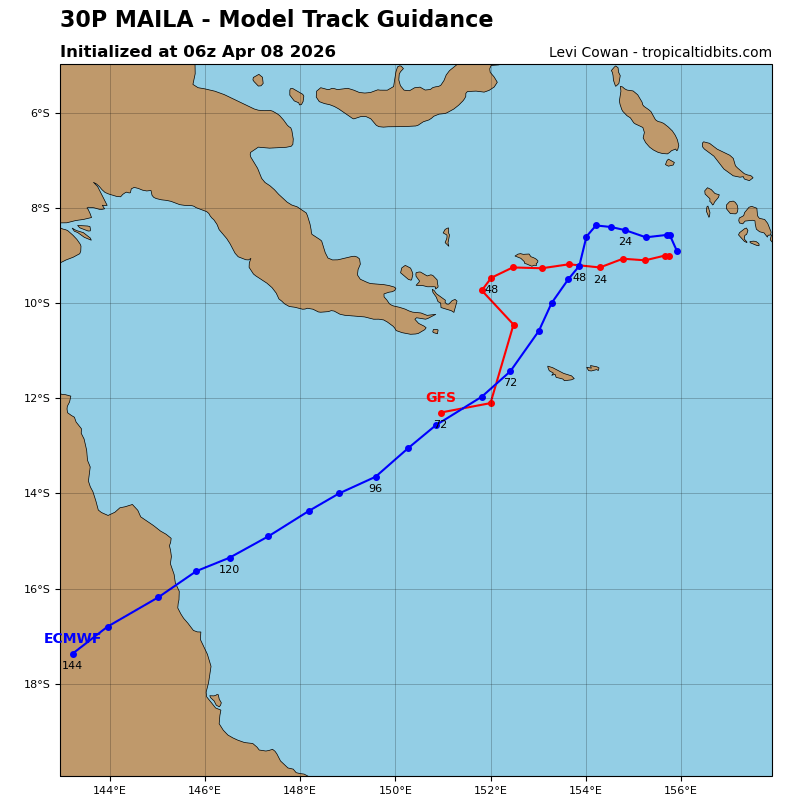
TC 30P is expected to maintain a slow (3-4 kts) generally westward propagation over the next 24 hours. Subsequently, a gradual acceleration toward the west-southwest is anticipated and driven by the repositioning of a deep-layer ridge centered to the south of the system. This projected trajectory maintains TC 30P on a course just south of the Papuan Peninsula, with
potential frictional effects driven by the land interaction.
After 72 hours, TC Maila will turn westward again, as the ridging builds further and steers the system towards the mostly flat Cape York Peninsula, Australia. The coupled models continue to depict a significant oceanic cold wake (below 26 c) directly along the forecast path, which would typically lead to a cessation of intensification. However, the observed persistent deepening suggests the cold pool may be less extensive or that ambient sea surface temperatures are warmer than modeled.
Given the otherwise conducive atmospheric and oceanic parameters, slight but persistent intensification is forecast, with a peak intensity of approximately 110-115 kts projected between 12 and 24 hours. Thereafter, a steady decay phase is expected to begin, driven by increasing mid-level vertical wind shear (projected to reach 35 kts around 72 hours) and the potential for land induced frictional weakening from the Owen Stanley Range, Papua New Guinea.
Tropical Cyclone 31P (Vaianu)
According to the JTWC warning number 13, sustained winds are 60 knots with gusts to 75 knots
Animated multi-spectral satellite imagery (msi) depicts tropical cyclone 31P (Vaianu) continuing its southeastward transit along the southwestern flank of a near-equatorial ridge (ner). The intensity of the westerly vertical wind shear has increased significantly and is now well exceeding 30 kts, resulting in decoupling of the deep convection poleward and eastward. the low-level circulation center is still obscured, but the northwestern quadrant is becoming increasingly exposed.
Additional environmental analysis reveals continued entrainment of dry, mid-tropospheric air from the north and cooling sea surface temperatures, culminating in a marginally unfavorable environment for significant reorganization. Partially mitigating these negative factors are still relatively warm (26-27 c) sea surface temperatures and robust poleward-directed outflow channel aloft.
TC 31P is forecast to continue on its present southeastward heading through 36 hours, under the persistent steering influence of the aforementioned near-equatorial ridge. Beyond that time frame, the cyclone is slated to cross to the poleward side of he subtropical jet axis, entering an area of increasing synoptic-scale forcing associated with an amplifying upper-level trough. During this time frame, vertical wind shear is expected to significantly abate. While model fields show a significant amount of dry air surrounding the system, TC 31P is expected to maintain a
broad wind field and a fairly symmetrical and moist structure, resulting in a brief period of preserved intensity.
Around 48 hours an extension of a deep-layer ridging located to the southeast will prompt a transient deflection and acceleration of the system toward the southwest until TC Vaianu rounds the axis of the ridge extension shortly after 72 hours. Concurrently, the initiation of a subtropical transition is imminent as the cyclone traverses a significantly cooler sea surface temperature gradient (below 26c). The subtropical transition (stt) process is forecast to conclude just prior to 96 hours as the remnant circulation crosses the coastline of north island, New Zealand and becomes embedded within the primary jet streak flow.
With respect to intensity, a steady attrition is projected as vertical wind shear is expected to further increase to 35-40 kts by 24 hours. as the shear vector is forecast to moderate around 48 hours, the rate of decay should diminish, with the dynamic interaction with the upper-level trough expected to help maintain a vortex intensity of 40-45 kts deep into its subtropical phase. While the system makes landfall over New Zealand, frictional effects of land interaction will further accelerate the weakening phase and potentially completely dissipate the vortex concurrently to completion of the stt.