
")
Current Snapshot
For all the latest updates visit: DisasterAWARE
GOES18-TPW-13-900×540
indusa
29S_021200sair
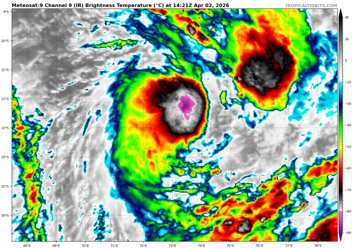
meteosat9_ir_29S_202604021421_lat-12.6-lon73.2
29S_tracks_latest
90P_022230sair
himawari9_ir_90P_202604021350_lat-10.3-lon156.0

90P_tracks_latest
By PDC’s Senior Weather
Specialist Glenn James

The Pacific Disaster Center’s (PDC Global) Thursday, April 2, 2026, Tropical Cyclone Activity Report…for the Pacific Ocean, the Indian Ocean, and adjacent Seas
Current Tropical Cyclones:
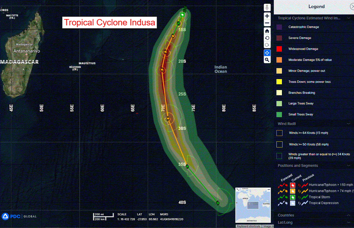
Tropical Cyclone 29S (Indusa)…is located approximately 335 NM south of Diego Garcia
Northeast Pacific Ocean: There are no Tropical Cyclones
The last regularly scheduled Tropical Cyclone Activity Report of the 2025 eastern North Pacific Hurricane Season has been issued. Routine issuance of this section of the PDC product will resume on May 15, 2026. During the off-season, Special Tropical Weather Outlooks will be issued as conditions warrant by the NHC.
Central Pacific Ocean: There are no Tropical Cyclones
The 2025 central North Pacific hurricane season has ended. As such, the final routine Tropical Cyclone Activity Report for the 2025 season has been issued. Routine issuance of this section of the PDC product will resume on June 1, 2026. During the off-season, Special Tropical Weather Outlooks will be issued as conditions warrant by the CPHC.
Western Pacific, Indian Ocean, and adjacent Seas:
South Indian Ocean
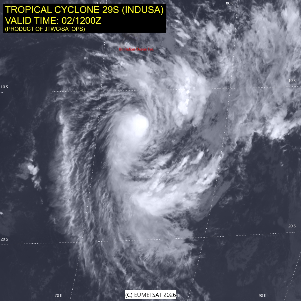
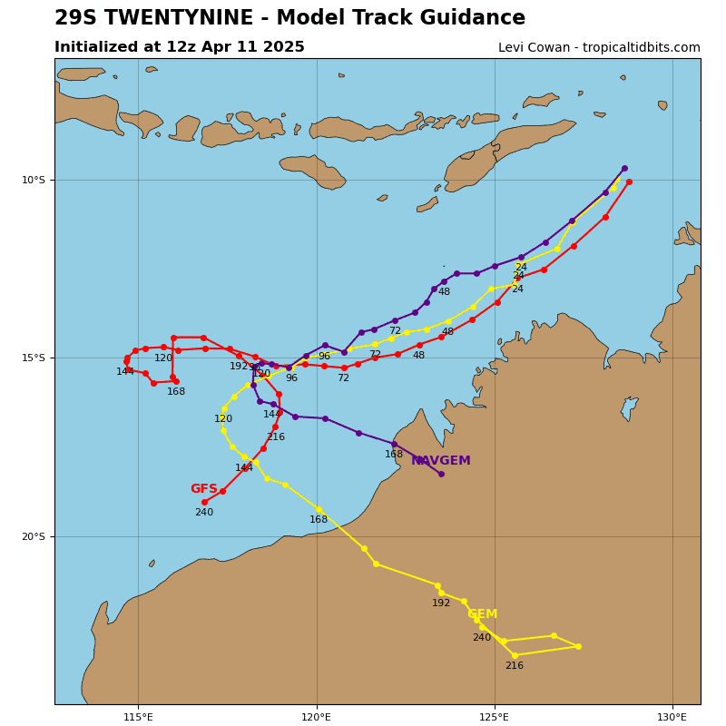
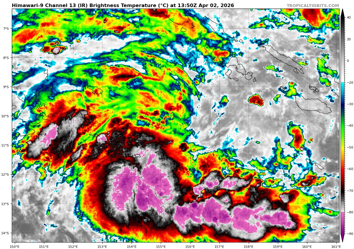
Tropical Cyclone 29S (Indusa)
According to the JTWC warning number 4, sustained winds are 55 knots with gusts to 70 knots
Animated multi-spectral satellite imagery (msi) depicts a consolidating, compact tropical cyclone 29S (Indusa) slowly tracking southwestward under the influence of a deep-layer subtropical ridge (str) centered to the southeast. After a brief period of intense convection producing a central dense overcast (cdo) feature, the system now displays a more pronounced convective banding wrapping into the low-level circulation center (llcc).
Some drier air is entering the core of the vortex, slightly slowing down development, while other environmental parameters remain highly favorable for rapid intensification – sea surface temperatures are very warm (29-30 c),
vertical wind shear (vws) is low (5-10 kts) and upper level outflow
remains strong, primarily in the poleward direction.
TC Indusa is forecast to continue tracking along the northwestern periphery of a str centered to the southeast until at least 48 hours. The environment is expected to remain highly favorable resulting in steady, near-rapid intensification throughout this time frame. There is a possibility that the system
will reach intensity beyond the currently forecast peak of 85 kts shortly after 48 hours, but prior to 72 hours, which the current warning graphic is not able to visualize.
As the system rounds the axis of the ridge around 72 hours, it is expected to begin interacting with a tail end of an upper level jet, resulting in a weakening trend and beginning of an extratropical transition (ett). The environment will then become increasingly less favorable, with dry air entering the system from the north and west, multiplied by rapidly increasing vertical wind shear and cooling sea surface temperatures.
Before 120 hours, the circulation is expected to increase in size and become
significantly less symmetric, with the core wind speeds decreasing. TC 29S is expected to complete the ett just prior to 120 hours, as it positions itself underneath the strong, upper-level westerlies.
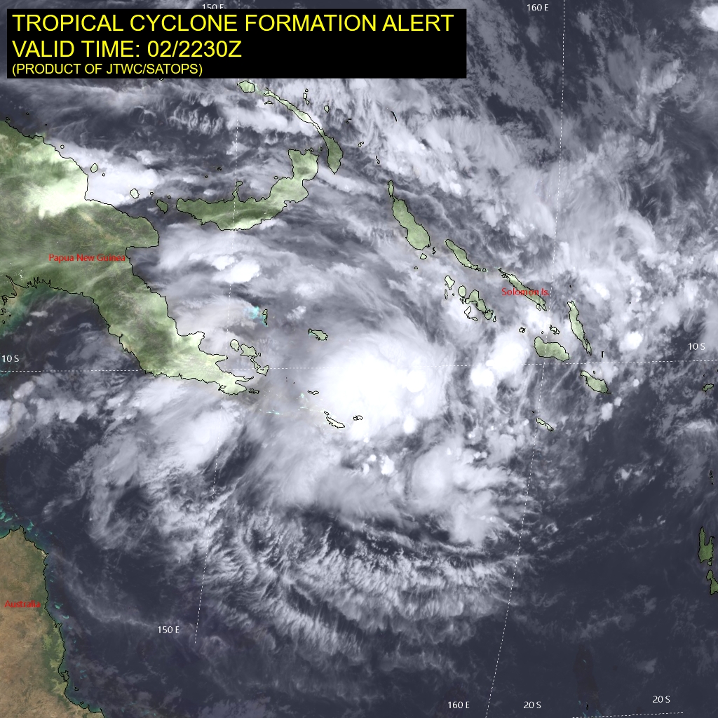
>>> There’s an area of disturbed weather being referred to as Invest 90P, which is located approximately 467 NM east of Port Moresby, Papua New Guinea
Animated enhanced multi-spectral satellite imagery (msi) depicts a consolidating low-level circulation center (llcc) embedded within persistent deep convection with spiral bands of deep convection wrapping into the center.
Environmental analysis for the area indicates a marginally favorable environment for cyclogenesis with low to moderate (15-20 kts) vertical wind shear, warm sea surface temperatures (29-30 c), and robust poleward outflow aloft.
Global deterministic and ensemble models, in addition to the experimental google deep mind ensemble, indicate quasi-stationary movement with quick consolidation and development over the next 24 hours.
Maximum sustained surface winds are estimated at 23 to 28 knots.
The potential for the development of a significant tropical cyclone within the next 24 hours is upgraded to high.