
")
Current Snapshot
For all the latest updates visit: DisasterAWARE
GOES18-TPW-13-900×540
narelle
27P_241200sair
himawari9_ir_27P_202603241450_lat-16.4-lon122.4
27P_tracks_latest
28p
himawari9_ir_28P_202603241450_lat-29.2-lon163.8
28P_geps_latest
By PDC’s Senior Weather
Specialist Glenn James

The Pacific Disaster Center’s (PDC Global) Tuesday, March 24, 2026, Tropical Cyclone Activity Report…for the Pacific Ocean, the Indian Ocean, and adjacent Seas
Current Tropical Cyclones:
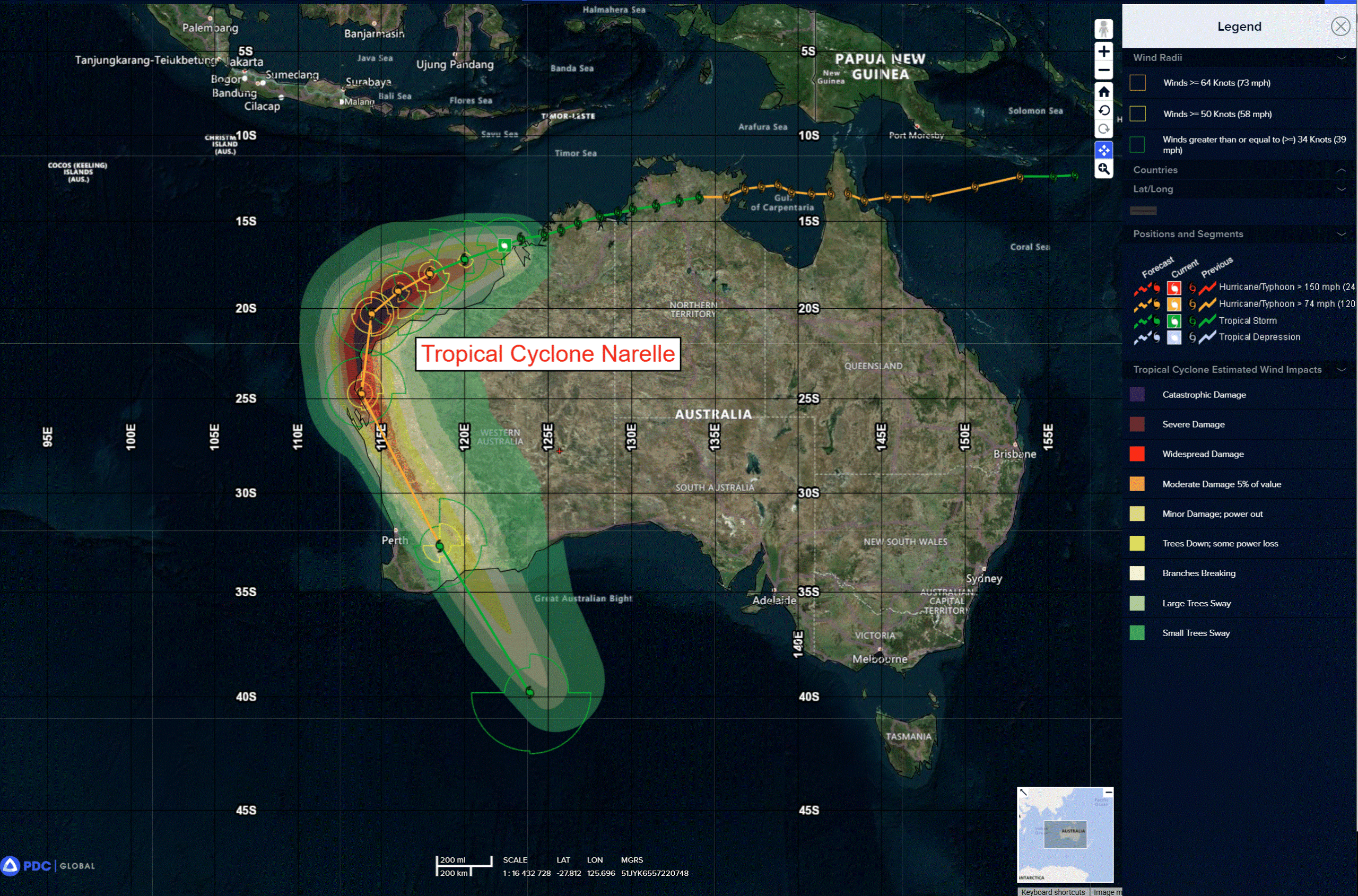
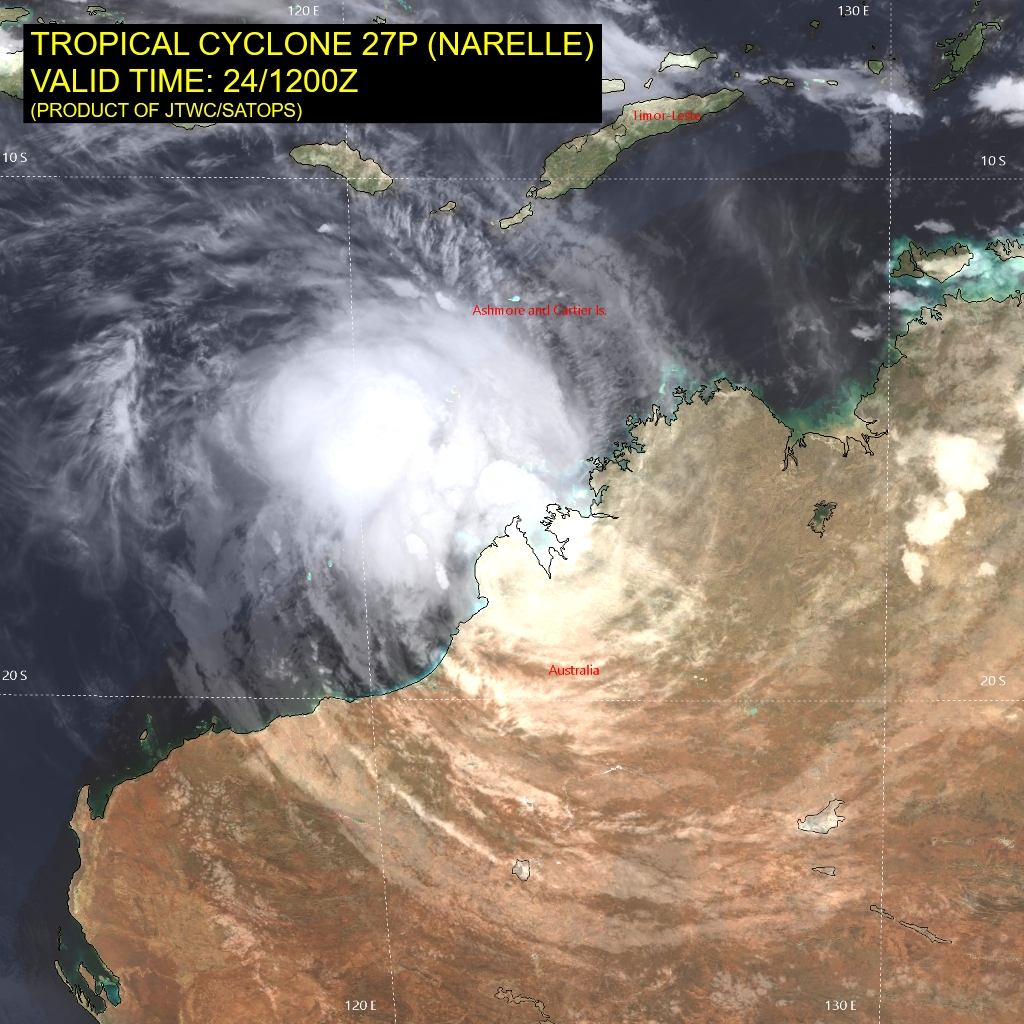
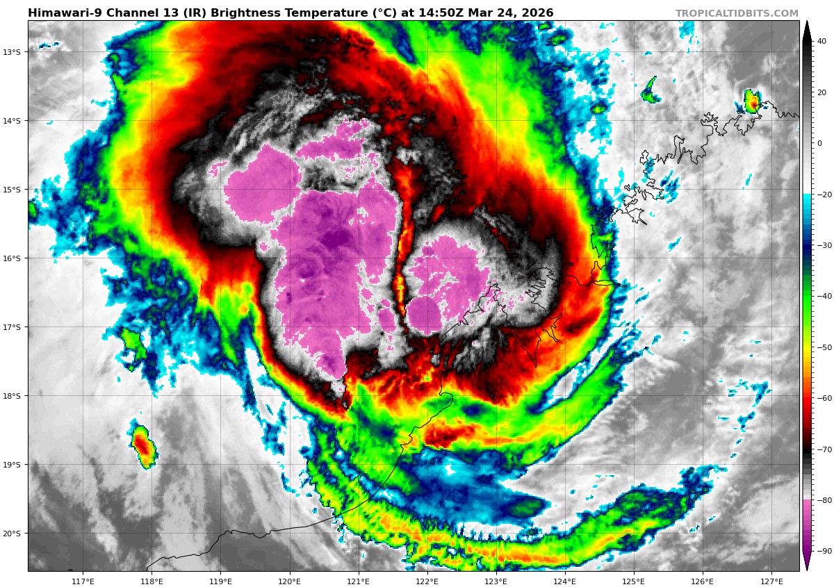
Tropical Cyclone 27P (Narelle)…is located approximately 129 NM west-northwest of Broome, Australia
Northeast Pacific Ocean: There are no Tropical Cyclones
The last regularly scheduled Tropical Cyclone Activity Report of the 2025 eastern North Pacific Hurricane Season has been issued. Routine issuance of this section of the PDC product will resume on May 15, 2026. During the off-season, Special Tropical Weather Outlooks will be issued as conditions warrant by the NHC.
Central Pacific Ocean: There are no Tropical Cyclones
The 2025 central North Pacific hurricane season has ended. As such, the final routine Tropical Cyclone Activity Report for the 2025 season has been issued. Routine issuance of this section of the PDC product will resume on June 1, 2026. During the off-season, Special Tropical Weather Outlooks will be issued as conditions warrant by the CPHC.
Western Pacific, Indian Ocean, and adjacent Seas:
SW Pacific Ocean
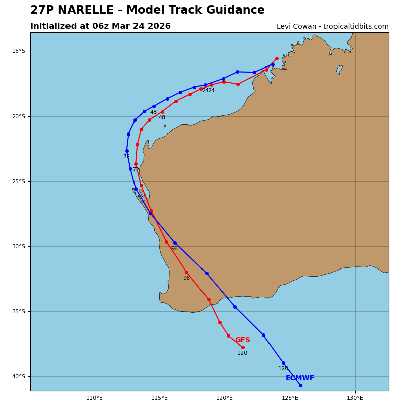
Tropical Cyclone 27P (Narelle)
According to the JTWC warning number 29, the sustained winds were 55 knots with gusts to near 70 knots
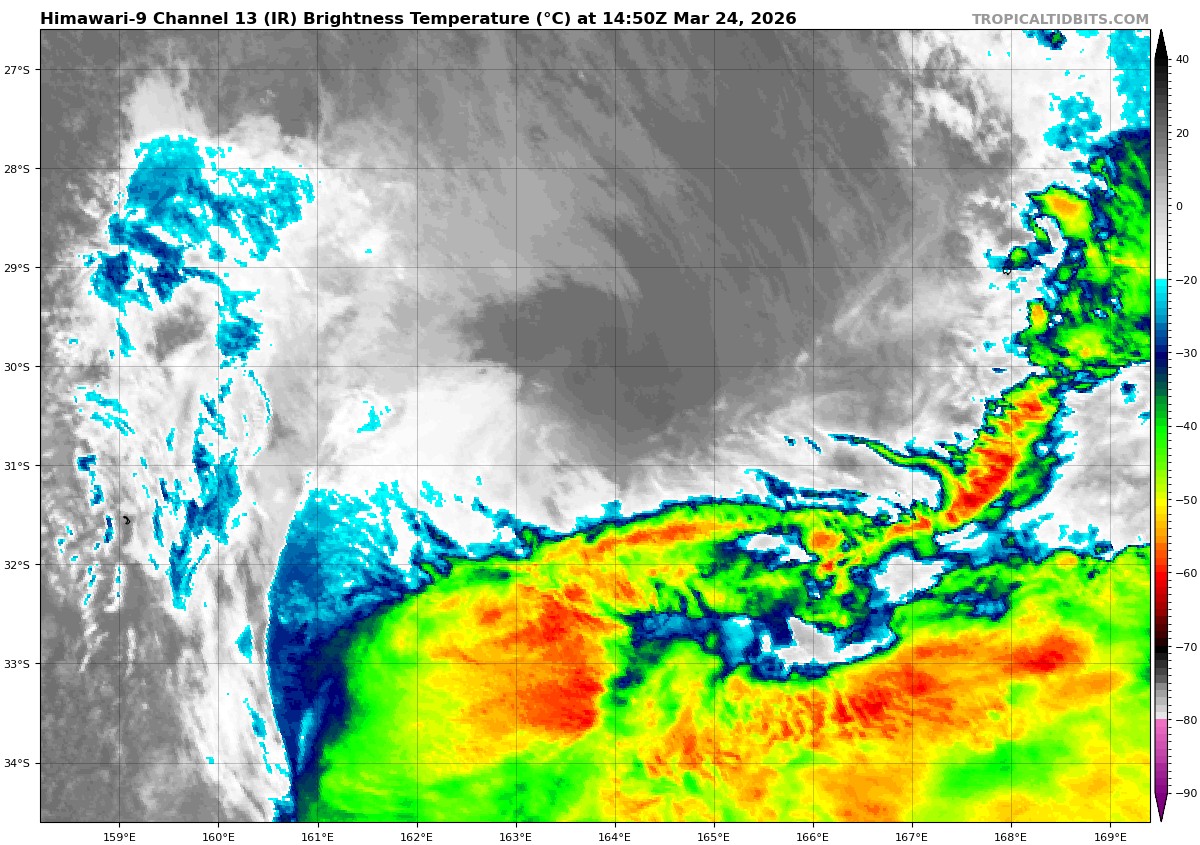
Animated enhanced infrared (eir) satellite imagery reveals spiral banding of deep convection undergoing continuous development as the low-level circulation center (llcc) of tropical cyclone 27P (Narelle) is transiting over the warm (29-30 c) waters of the Indian Ocean, northwest of the Dampier Peninsula, Australia. Cloud tops have been cooling, while the size of convective canopy is increasing and fully obscuring the llcc.
Additional environmental analysis reveals moderate, primarily westward and poleward outflow, low (10-15 kts) vertical wind shear (vws) and a deep moisture layer present throughout the tropospheric column.
TC 27P is forecast to continue its trajectory along the northwestern periphery of a subtropical ridge (str) centered over Australia, while concurrently undergoing rapid intensification. A peak intensity of 100 kts is anticipated around 48 hours, just prior to the system rounding the ridge axis and approaching NW Cape, Australia. A period of rapid intensification is expected given the highly conducive environmental conditions forecast through 48 hours.
Most recent guidance very narrowly shifts the track westward, with remaining possibility for landfall over western portion of the NW Cape, or just to the south of the peninsula, closer to Ningaloo. As the system rounds the ridge axis it will begin tracking southeastward.
Subsequently, the system is expected to weaken due to terrain-induced frictional effects, increasing mid-level dry air entrainment, and rapidly increasing vws associated with interaction with the subtropical jet. Around 96 hours, subtropical transition (stt) is expected to commence, with completion anticipated by or before 120 hours.
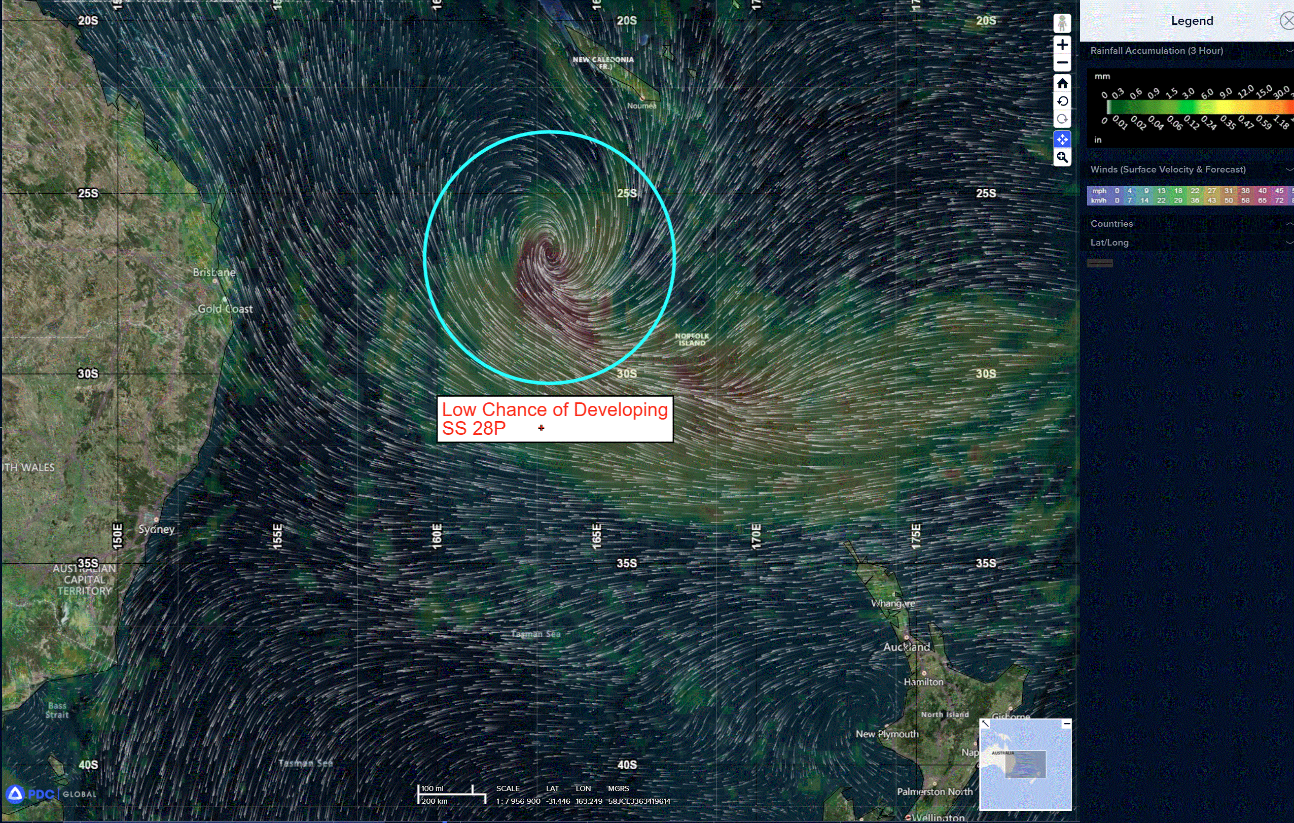
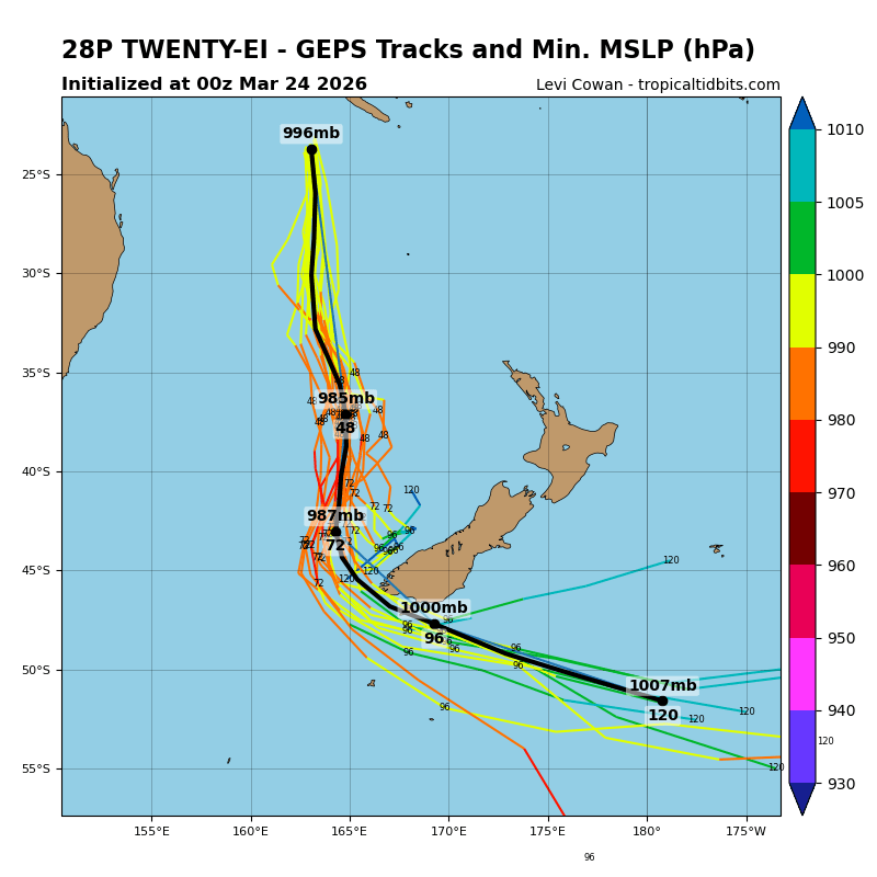
>>> There’s an area of disturbed weather being referred to as SS 28P, which is located approximately 724 NM south-southwest of Noumea, New Caledonia
The system is currently classified as a subtropical cyclone, generally characterized as having both tropical and mid-latitude cyclone features.
Animated enhanced multi-spectral satellite imagery depicts a weak frontal system with flaring convection located just poleward of the low-level circulation center (llcc). The system has continued to be sheared to the south-southeast, with 30-35 knot winds along the southern periphery as well as the llcc becoming fully exposed in the last six hours.
Environmental analysis reveals unfavorable conditions for tropical transition moving forward, defined by a deep layer of mid-level dry air being entrained throughout the systems core, strong outflow aloft, high vertical wind shear (vws) of 40-50 kts from the north-northwest, and cooling sea surface temperatures of 25-26 c.
Global models are in agreement that subtropical cyclone 28P will track southward as the broad and asymmetric wind field continues to expand over time.
Maximum sustained surface winds are estimated at 33 to 37 knots.
The potential for the development of a significant tropical cyclone within the next 24 hours remains low.