
")
Current Snapshot
For all the latest updates visit: DisasterAWARE

1800×1080
melissa
melissa close
goes19_ir_13L_202510281315_lat17.5-lon-78.1
GOES19-CAR-13-1000×1000
281259_earliest_reasonable_toa_34
281259INTQPF_sm
13L_tracks_latest
By PDC’s Senior Weather
Specialist Glenn James

The Pacific Disaster Center’s (PDC Global) Tuesday, October 28, 2025, Tropical Cyclone Activity Report…for the Atlantic Ocean, the Caribbean Sea, and the Gulf of America
Current Tropical Cyclones:
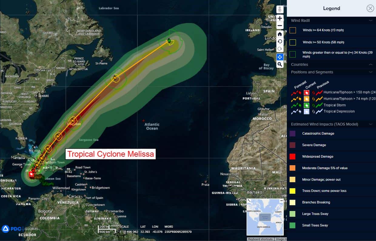
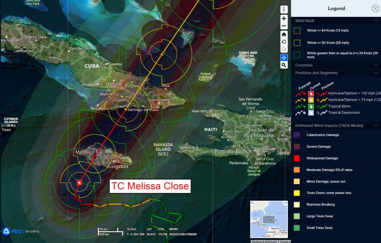
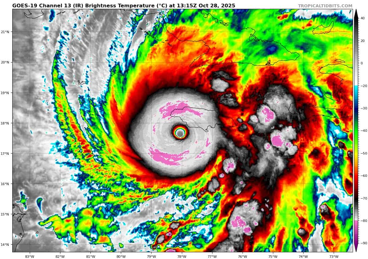
Tropical Cyclone Melissa…is located about 200 miles southwest of Guantanamo, Cuba
Atlantic Ocean: There are no active tropical cyclones
Tropical cyclone formation is not expected during the next 7-days.
Caribbean Sea:
Tropical Cyclone Melissa
CENTER OF MELISSA EMERGING FROM THE NORTHERN COAST OF WESTERN JAMAICA…DAMAGING WINDS. CATASTROPHIC FLASH FLOODING, AND LIFE-THREATENING STORM SURGE CONTINUES IN JAMAICA
According to the NHC advisory number 30
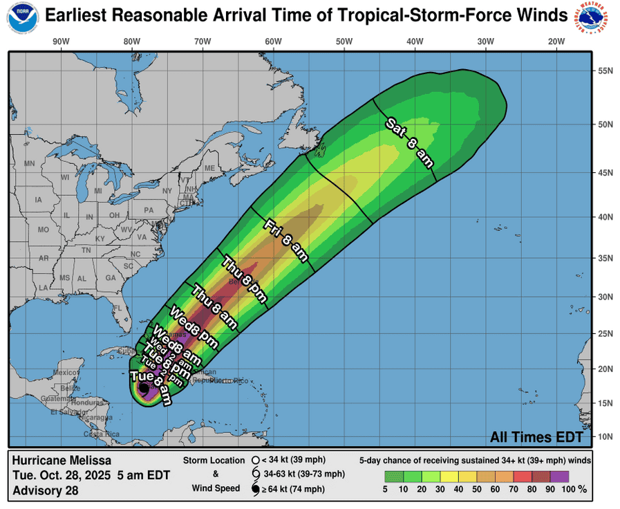
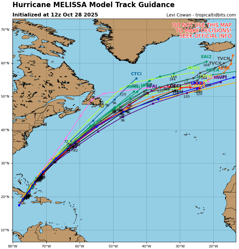
Melissa is moving toward the north-northeast near 8 mph (13 km/h). A turn toward the northeast with an increase in forward speed is expected this evening, followed by a faster northeastward motion on Wednesday and Thursday. On the forecast track, the core of Melissa will move away from western Jamaica this evening. After that, the center is expected to move over southeastern Cuba later tonight and early Wednesday morning, move across the southeastern or central Bahamas later on Wednesday, and approach Bermuda Thursday and Thursday night.
Maximum sustained winds are near 145 mph (230 km/h) with higher gusts. Melissa is a category 4 hurricane on the Saffir-Simpson Hurricane Wind Scale. Melissa is expected to reach southeastern Cuba as an extremely dangerous major hurricane, and it could still be a major hurricane when it moves across the southeastern Bahamas.
NOAA and Air Force Reserve Hurricane Hunter aircraft will be investigating Melissa this evening. Hurricane-force winds extend outward up to 30 miles (45 km) from the center and tropical-storm-force winds extend outward up to 195 miles (315 km). The estimated minimum central pressure is 921 mb (27.20 inches).
HAZARDS AFFECTING LAND
WIND: Tropical storm conditions are occurring in Jamaica, and catastrophic hurricane-force winds are expected to begin during the next few hours. Within the eyewall, total structural failure is likely, especially in higher elevation areas where wind speeds atop and on the windward sides of hills and mountains could be up to 30 percent stronger.
Tropical storm conditions are expected to begin in eastern Cuba today, with hurricane conditions expected in the hurricane warning area starting tonight into Wednesday morning. Tropical storm conditions are expected in Haiti later today and Wednesday.
Hurricane conditions are expected in the southeastern and central Bahamas on Wednesday. Tropical storm conditions are expected and hurricane conditions are possible in the Turks and Caicos Islands on Wednesday.
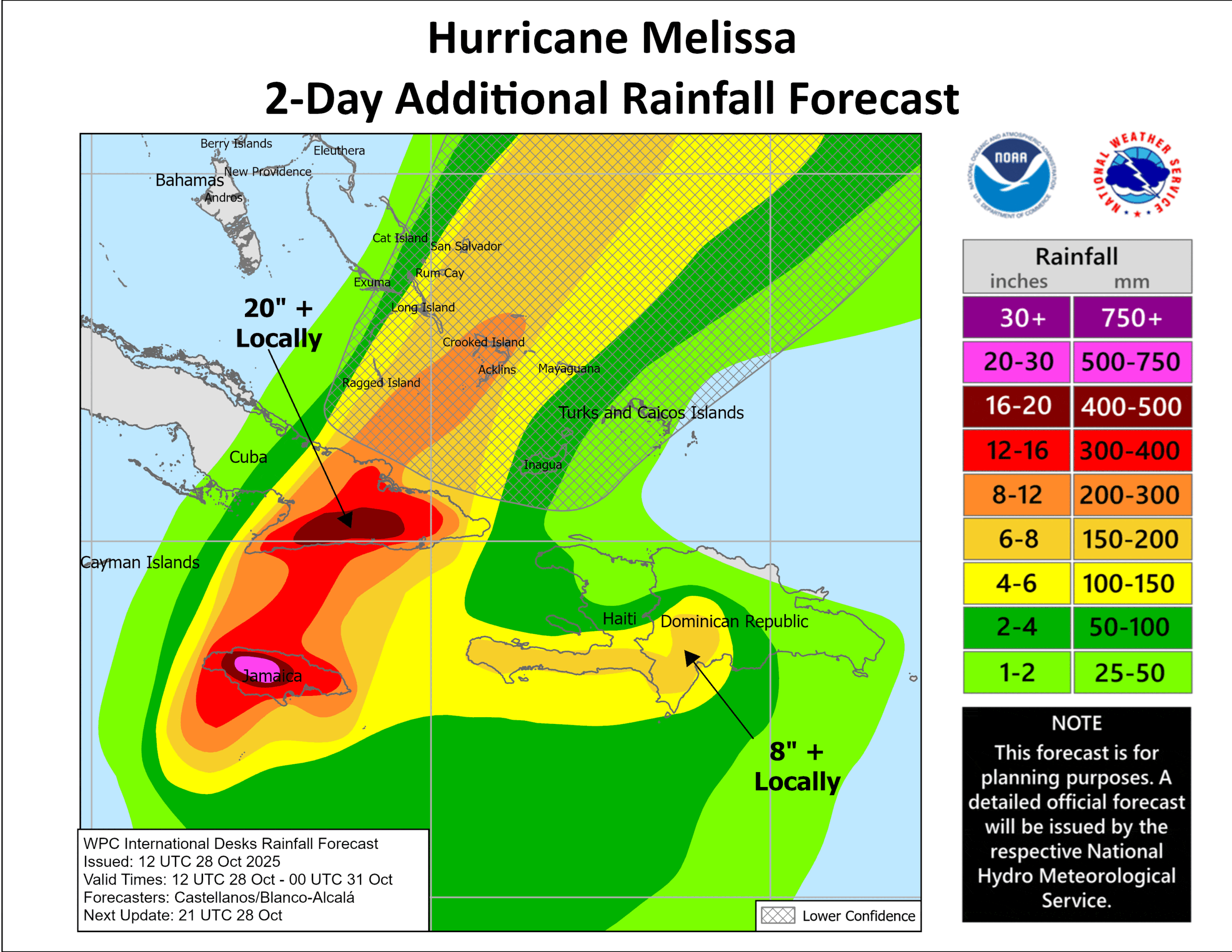
RAINFALL:Melissa is expected to bring rainfall of 15 to 30 inches to portions of Jamaica and additional rainfall of 6 to 12 inches for southern Hispaniola through Wednesday, with storm total local maxima of 40 inches possible. Catastrophic flash flooding and numerous landslides are likely.
For eastern Cuba, storm total rainfall of 10 to 20 inches, with local amounts to 25 inches, is expected into Wednesday resulting in life-threatening and potentially catastrophic flash flooding with numerous landslides.
Over the Southeastern Bahamas and the Turks and Caicos, rain is expected to develop later today and continue into Wednesday. Total rainfall of 5 to 10 inches is expected to result in areas of flash flooding.
SURF: Swells generated by Melissa are expected to affect portions of Hispaniola, Jamaica, eastern Cuba, and the Cayman Islands during the next several days, likely causing life-threatening surf and rip current conditions. These swells will reach the Bahamas, the Turks and Caicos Islands, and Bermuda later this week.
STORM SURGE: A life-threatening storm surge is likely along the south coast of Jamaica today. Peak storm surge heights could reach 9 to 13 feet above ground level, near and to the east of where the center of Melissa makes landfall. This storm surge will be accompanied by large and destructive waves. On the northwest coast of Jamaica, near Montego Bay, there is the possibility of 2 to 4 feet of storm surge above ground level.
There is a potential for significant storm surge along the southeast coast of Cuba late today or Wednesday. Peak storm surge heights could reach 7 to 11 feet above normal tide levels, near and to the east of where the center of Melissa makes landfall. This storm surge will be accompanied by large and destructive waves.
Storm surge of 4 to 6 ft above normally dry ground is possible in the southeastern Bahamas and Turks and Caicos Islands on Wednesday.
Gulf of America: There are no active tropical cyclones
Tropical cyclone formation is not expected during the next 7-days.