
")
Current Snapshot
For all the latest updates visit: DisasterAWARE
1800×1080
melissa one
melissa two

1000×1000
GOES19-CAR-13-1000×1000
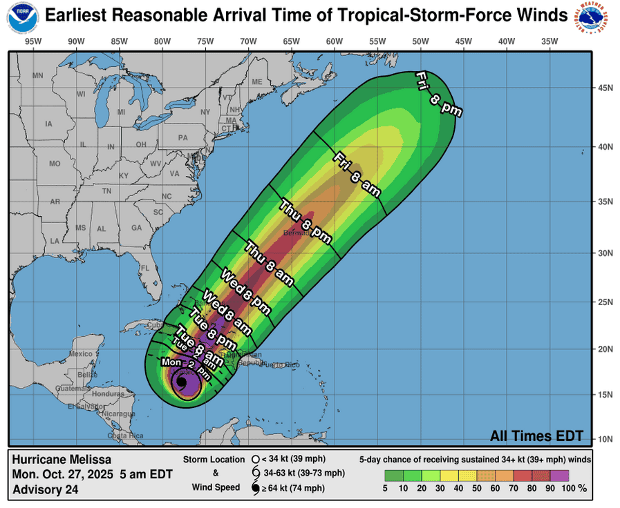
271147_earliest_reasonable_toa_34
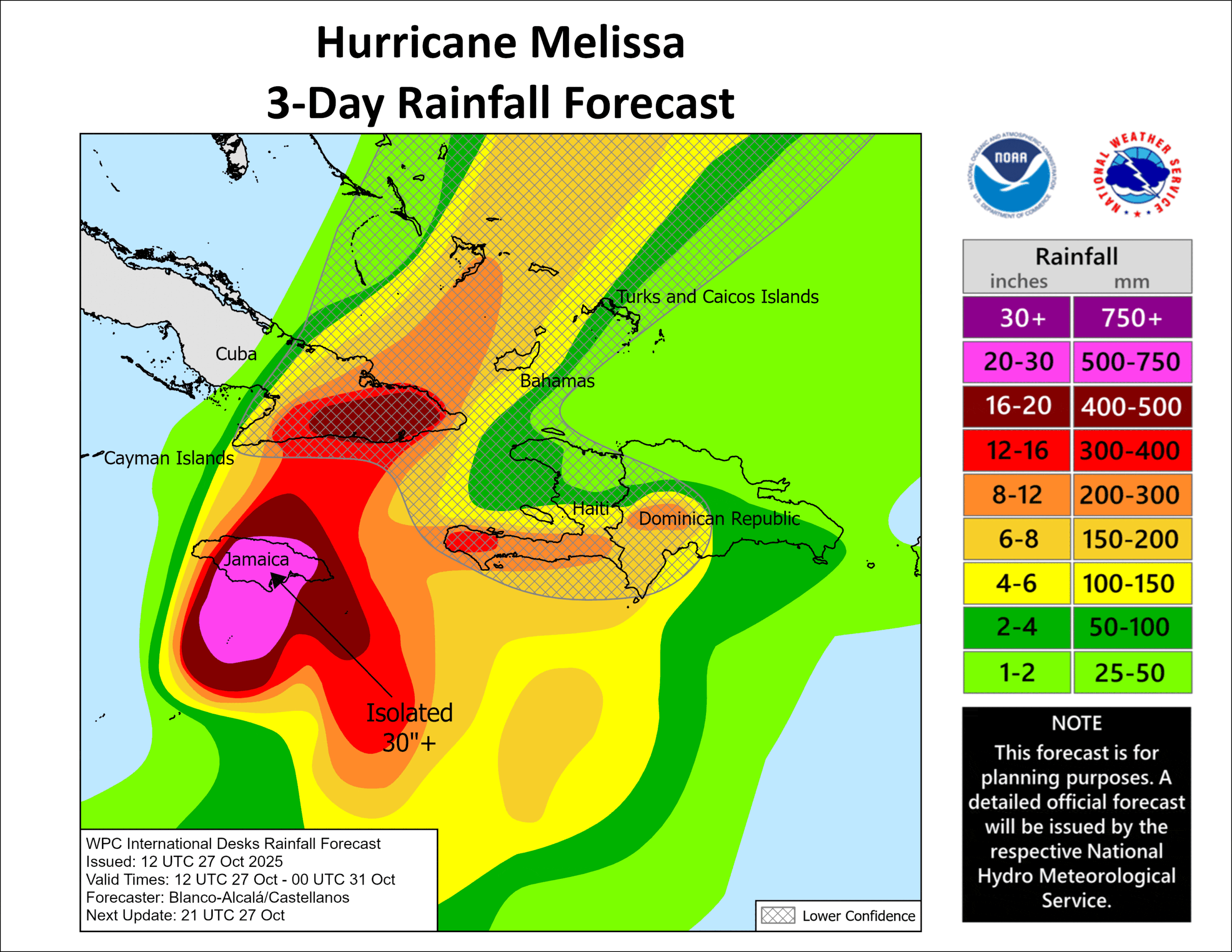
271147INTQPF_sm
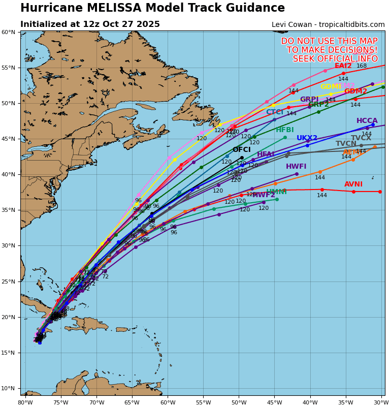
13L_tracks_latest
By PDC’s Senior Weather
Specialist Glenn James

The Pacific Disaster Center’s (PDC Global) Monday, October 27, 2025, Tropical Cyclone Activity Report…for the Atlantic Ocean, the Caribbean Sea, and the Gulf of America
Current Tropical Cyclones:
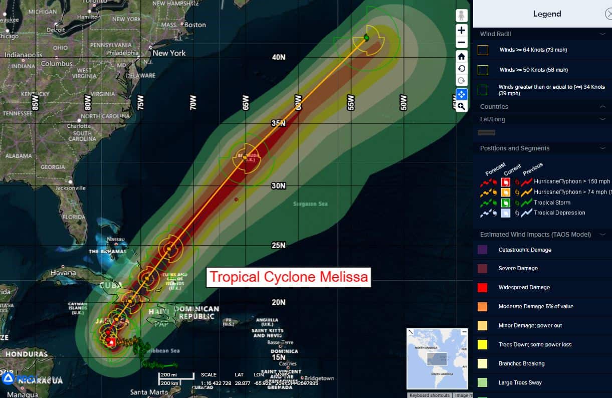
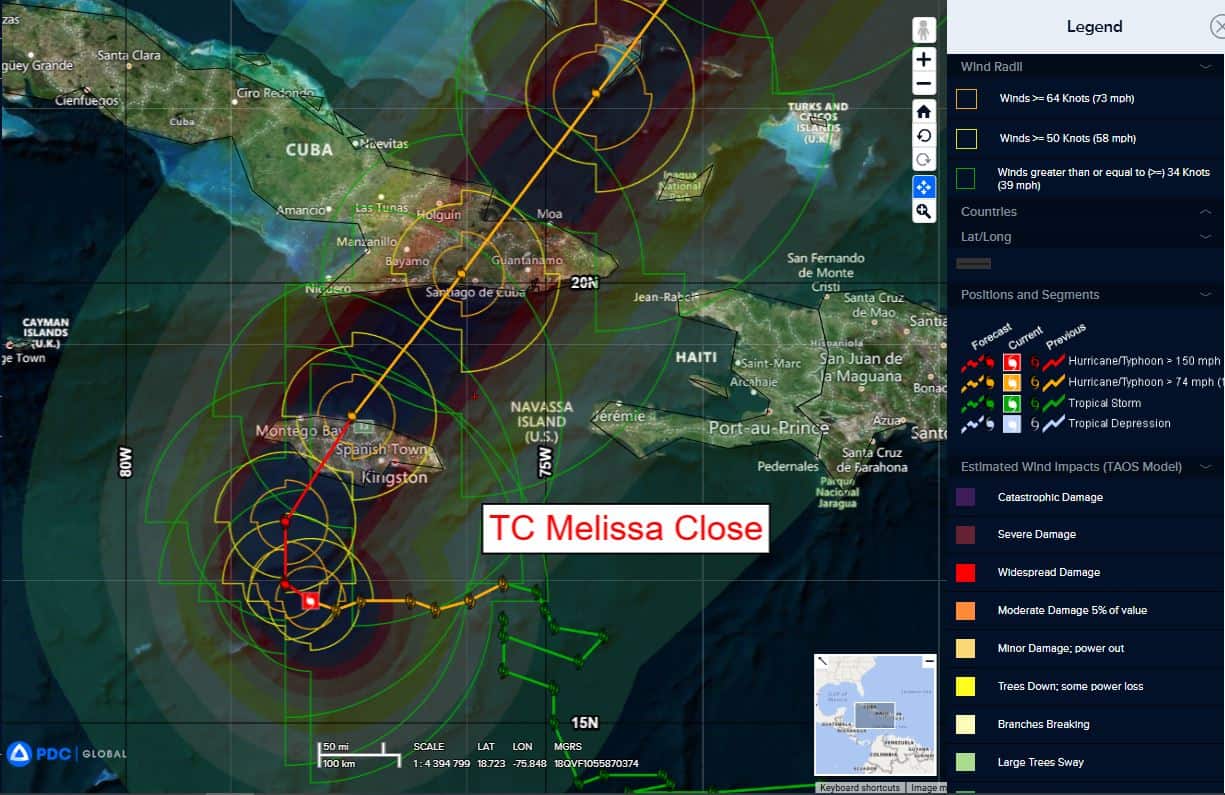
Tropical Cyclone Melissa…is located about 320 miles southwest of Guantanamo, Cuba
Atlantic Ocean: There are no active tropical cyclones
Tropical cyclone formation is not expected during the next 7-days.
Caribbean Sea:
Tropical Cyclone Melissa
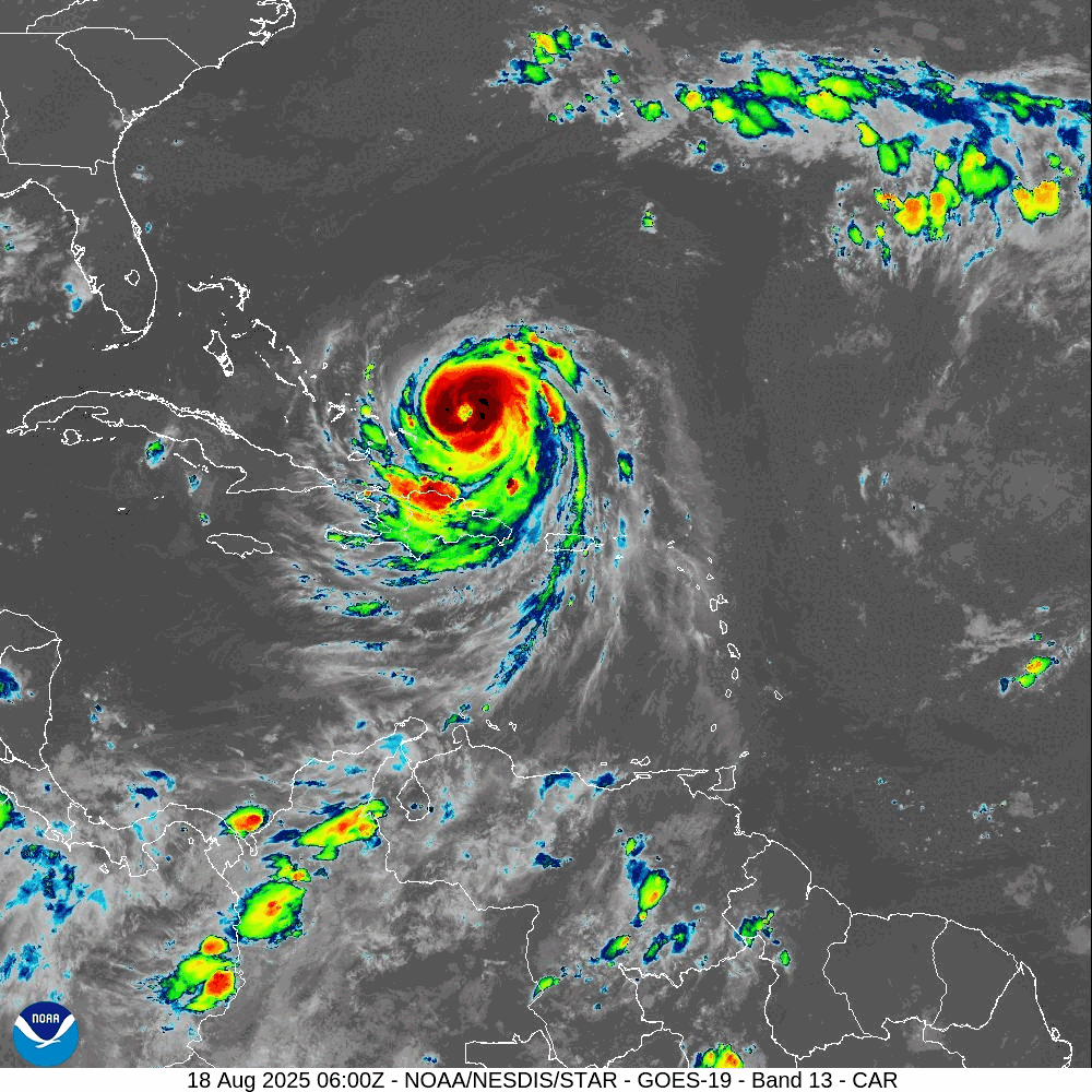
NOAA AND AIR FORCE RESERVE HURRICANE HUNTERS INVESTIGATING CATEGORY 5 MELISSA…DESTRUCTIVE WINDS AND STORM SURGE AND CATASTROPHIC FLOODING WILL WORSEN ON JAMAICA THROUGH THE DAY AND INTO TONIGHT
According to the NHC advisory number 24A
Melissa is moving toward the west near 3 mph (6 km/h). A slow turn toward the northwest and north is expected today and tonight, followed by a northeastward acceleration beginning on Tuesday and continuing through at least Thursday. On the forecast track, the core of Melissa is expected to move near or over Jamaica tonight and Tuesday, across southeastern Cuba Tuesday night, and across the southeastern Bahamas on Wednesday.
Reports from NOAA and Air Force Reserve Hurricane Hunter aircraft indicate that maximum sustained winds are near 160 mph (260 km/h) with higher gusts. Melissa is a category 5 hurricane on the Saffir-Simpson Hurricane Wind Scale. Some additional strengthening is forecast today, with fluctuations in intensity likely before Melissa makes landfall on Jamaica early Tuesday. Melissa is expected to reach Jamaica and southeastern Cuba as a powerful major hurricane, and will still be at hurricane strength when it moves across the southeastern Bahamas.
Hurricane-force winds extend outward up to 30 miles (45 km) from the center and tropical-storm-force winds extend outward up to 195 miles (315 km). The minimum central pressure from the Hurricane Hunter aircraft data is 913 mb (26.96 inches).
HAZARDS AFFECTING LAND
WIND: Tropical storm conditions are occurring in Jamaica, and destructive hurricane conditions are expected to begin tonight or early Tuesday. Wind speeds atop and on the windward sides of hills and mountains could be up to 30 percent stronger than the near-surface winds indicated in this advisory, and in some elevated locations could be even greater.
Tropical storm conditions are expected to begin in eastern Cuba on Tuesday, with hurricane conditions expected to begin in the hurricane warning area by Tuesday evening.
Tropical storm conditions are expected in Haiti late Tuesday and Wednesday. Tropical storm and hurricane conditions are possible in the southeastern and central Bahamas, as well as the Turks and Caicos Islands, on Wednesday.
RAINFALL: Melissa is expected to bring rainfall of 15 to 30 inches to portions of Jamaica and additional rainfall of 8 to 16 inches for southern Hispaniola through Wednesday, with storm total local maxima of 40 inches possible. Catastrophic flash flooding and numerous landslides are likely.
For eastern Cuba, storm total rainfall of 10 to 15 inches, with local amounts to 20 inches, is expected today through Wednesday resulting in life-threatening and potentially catastrophic flash flooding with numerous landslides.
Over the Southeast Bahamas, total rainfall of 4 to 8 inches is expected Tuesday into Wednesday resulting in areas of flash flooding.
SURF: Swells generated by Melissa are expected to affect portions of Hispaniola, Jamaica, eastern Cuba, and the Cayman Islands during the next several days, and the Bahamas, the Turks and Caicos Islands, and Bermuda later this week. These swells are likely to cause life-threatening surf and rip current conditions.
STORM SURGE: A life-threatening storm surge is likely along the south coast of Jamaica tonight and on Tuesday. Peak storm surge heights could reach 9 to 13 feet above ground level, near and to the east of where the center of Melissa makes landfall. This storm surge will be accompanied by large and destructive waves.
There is a potential for significant storm surge along the southeast coast of Cuba late Tuesday or Wednesday. Peak storm surge heights could reach 6 to 9 feet above normal tide levels, near and to the east of where the center of Melissa makes landfall. This storm surge will be accompanied by large and destructive waves.
Storm surge is possible in the southeastern Bahamas and Turks and Caicos Islands on Wednesday.
Gulf of America: There are no active tropical cyclones
Tropical cyclone formation is not expected during the next 7-days.