
")
Current Snapshot
For all the latest updates visit: DisasterAWARE

1800×1080
melissa
1000×1000
251152_earliest_reasonable_toa_34
251152INTQPF_sm
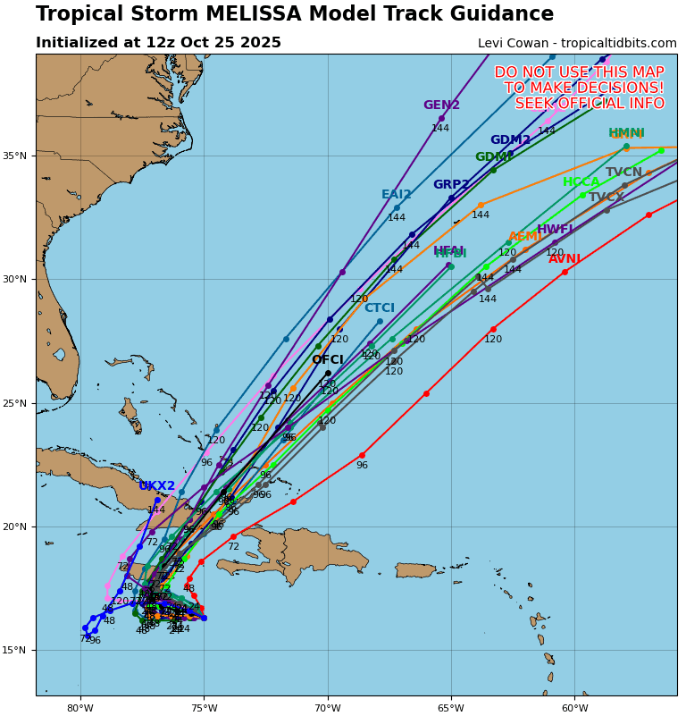
13L_tracks_latest
By PDC’s Senior Weather
Specialist Glenn James

The Pacific Disaster Center’s (PDC Global) Saturday, October 25, 2025, Tropical Cyclone Activity Report…for the Atlantic Ocean, the Caribbean Sea, and the Gulf of America
Current Tropical Cyclones:
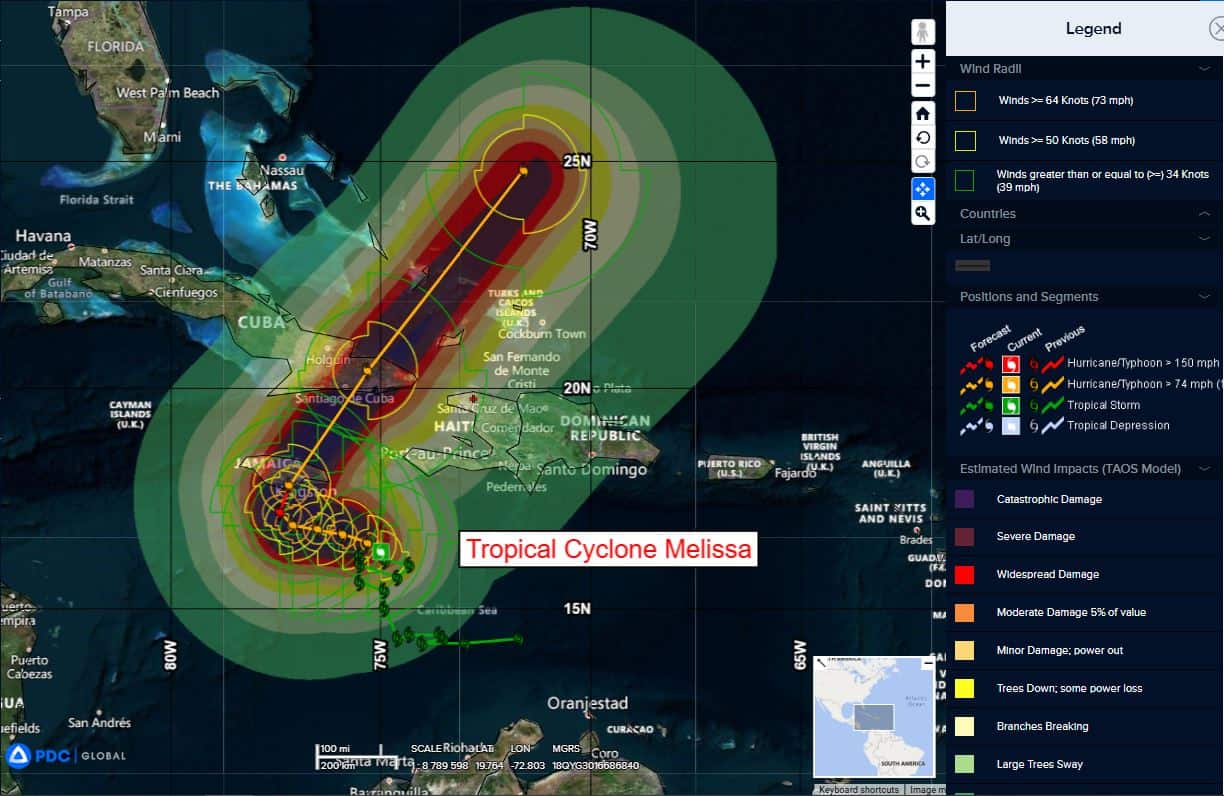
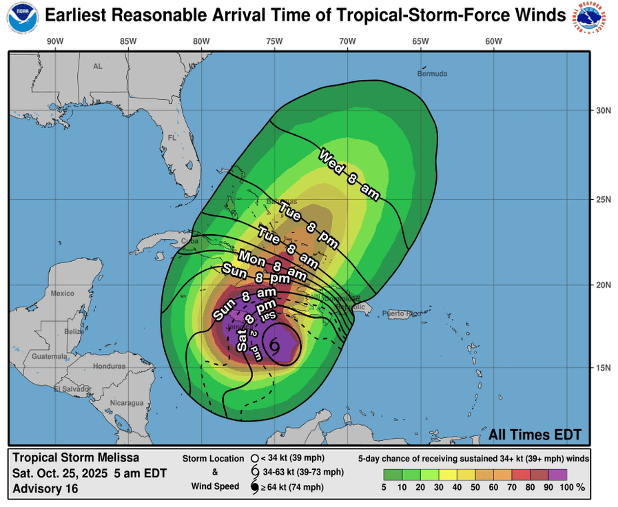
Tropical Cyclone Melissa…is located about 235 miles southwest of Port Au Prince, Haiti
Atlantic Ocean: There are no active tropical cyclones
Tropical cyclone formation is not expected during the next 7-days.
Caribbean Sea:
Tropical Cyclone Melissa
MELISSA BECOMES A HURRICANE AND IS EXPECTED TO RAPIDLY INTENSIFY INTO A MAJOR HURRICANE BY THE END OF THE WEEKEND …LIFE-THREATENING AND CATASTROPHIC FLASH FLOODING AND LANDSLIDES EXPECTED IN PORTIONS OF SOUTHERN HISPANIOLA AND JAMAICA INTO EARLY NEXT WEEK
According to the NHC advisory number 17A
Melissa is moving slowly toward the west-northwest near 1 mph (2 km/h). A slow west-northwestward or westward motion is expected today through the end of the weekend. A turn to the north and northeast is forecast on Monday and Tuesday. On the forecast track, the center of Melissa is expected to move near or over Jamaica during the weekend and early next week, and it could be near or over eastern Cuba by the middle of next week.
Maximum sustained winds have increased to near 75 mph (120 km/h) with higher gusts. Rapid intensification is forecast to occur over the next couple of days and Melissa is forecast to become a major hurricane by Sunday.
Hurricane-force winds extend outward up to 35 miles (55 km) from the center and tropical-storm-force winds extend outward up to 125 miles (205 km). The estimated minimum central pressure is 980 mb (28.94 inches).
HAZARDS AFFECTING LAND
WIND: Tropical storm conditions are expected to begin in Jamaica by tonight, with hurricane conditions expected by Sunday or Monday. Tropical storm conditions are expected and hurricane conditions are possible within the watch and warning area in Haiti later today.
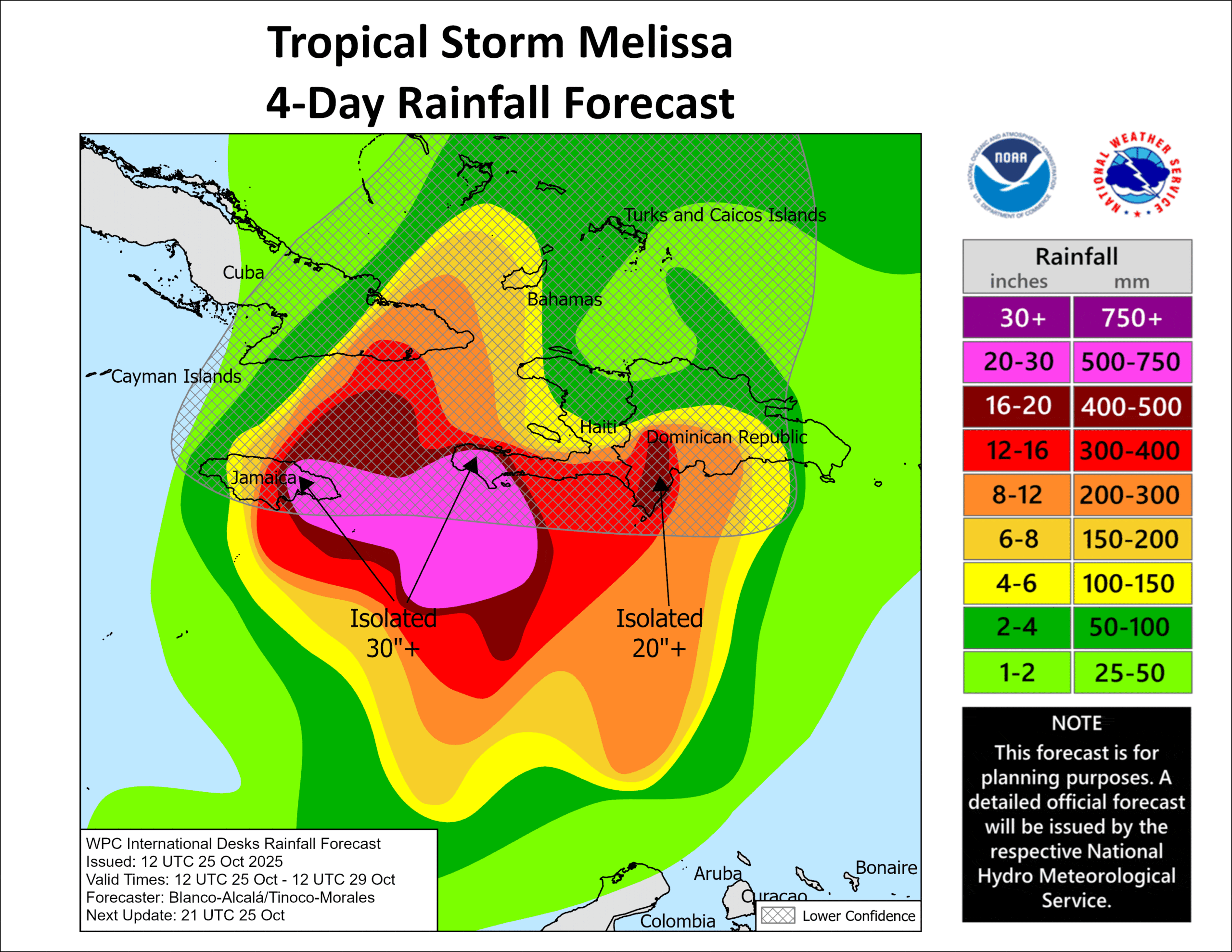
RAINFALL: Melissa is expected to bring total rainfall of 15 to 25 inches to portions of southern Hispaniola and Jamaica through Tuesday, with local maxima of 35 inches possible across the Tiburon Peninsula of Haiti. Additional heavy rainfall is likely beyond Tuesday; uncertainty at that time range precludes exact storm totals. Potential catastrophic flash flooding and landslides are possible across portions of Jamaica and the southern Dominican Republic, while catastrophic flash flooding is anticipated in southern Haiti.
For eastern Cuba, total rainfall of 4 to 8 inches, with local amounts to 12 inches, is possible into Tuesday. Additional heavy rainfall is likely beyond Tuesday; uncertainty at that time range precludes exact storm totals.
SURF: Swells generated by Melissa are expected to affect portions of Hispaniola, Jamaica, and eastern Cuba during the next several days.
STORM SURGE: Minor coastal flooding is likely along the coast of Jamaica starting by tonight in areas of onshore winds as tropical storm conditions begin to reach the area.
However, there is a risk of a more life-threatening storm surge, especially along the south coast of Jamaica, later in the weekend or early next week. Peak storm surge heights could reach 5 to 10 feet above ground level, near and to the east of where the center of Melissa makes landfall. This storm surge will be accompanied by large and destructive waves.
Gulf of America: There are no active tropical cyclones
Tropical cyclone formation is not expected during the next 7-days.