
")
Current Snapshot
For all the latest updates visit: DisasterAWARE
atlantic
2a
goes19_ir_08L_202509291607_lat27.5-lon-67.3
291440_earliest_reasonable_toa_34
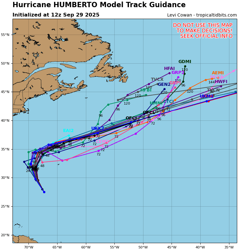
08L_tracks_latest
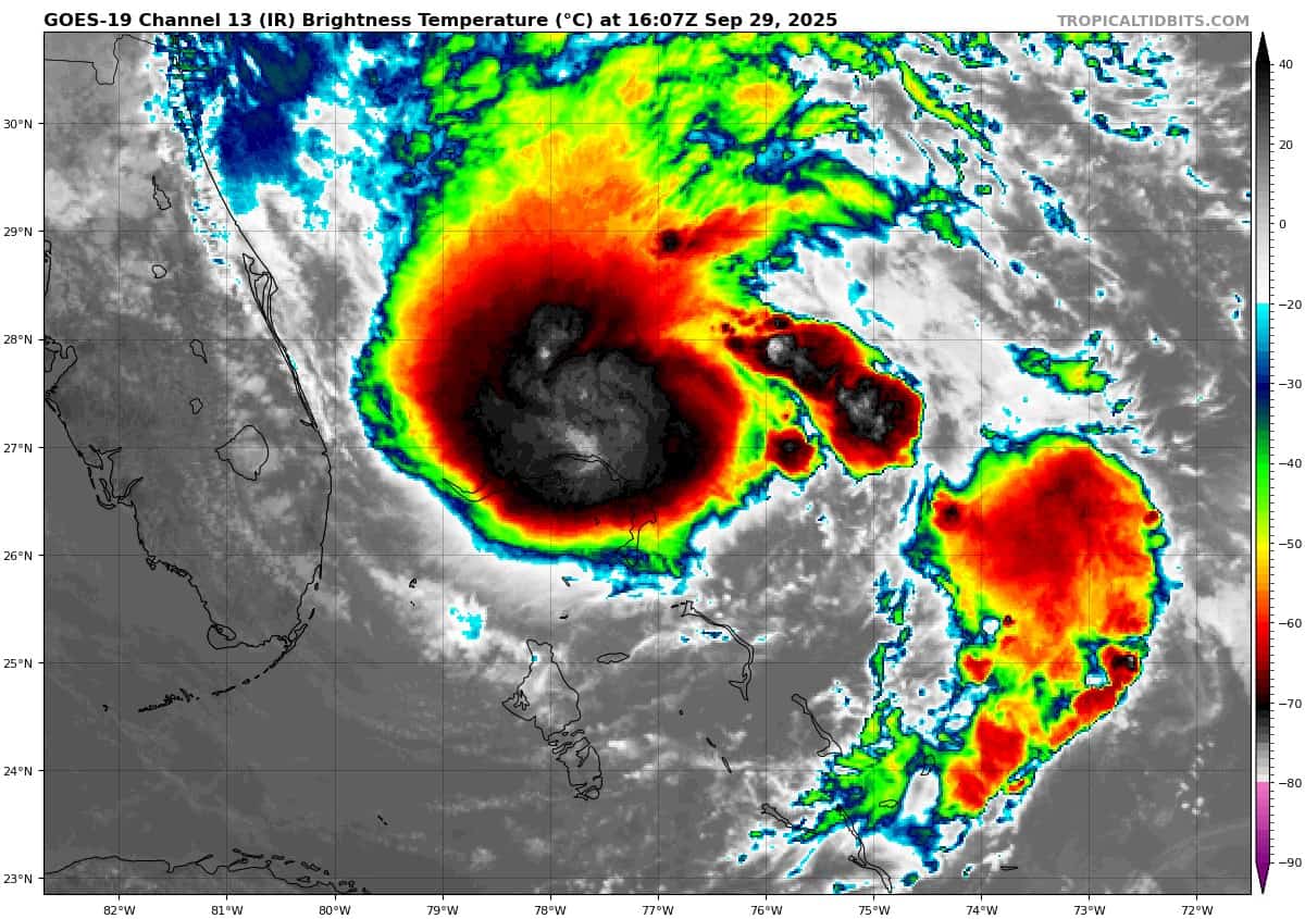
goes19_ir_09L_202509291607_lat26.4-lon-77.1
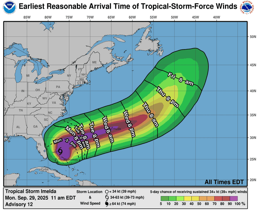
291454_earliest_reasonable_toa_34iii
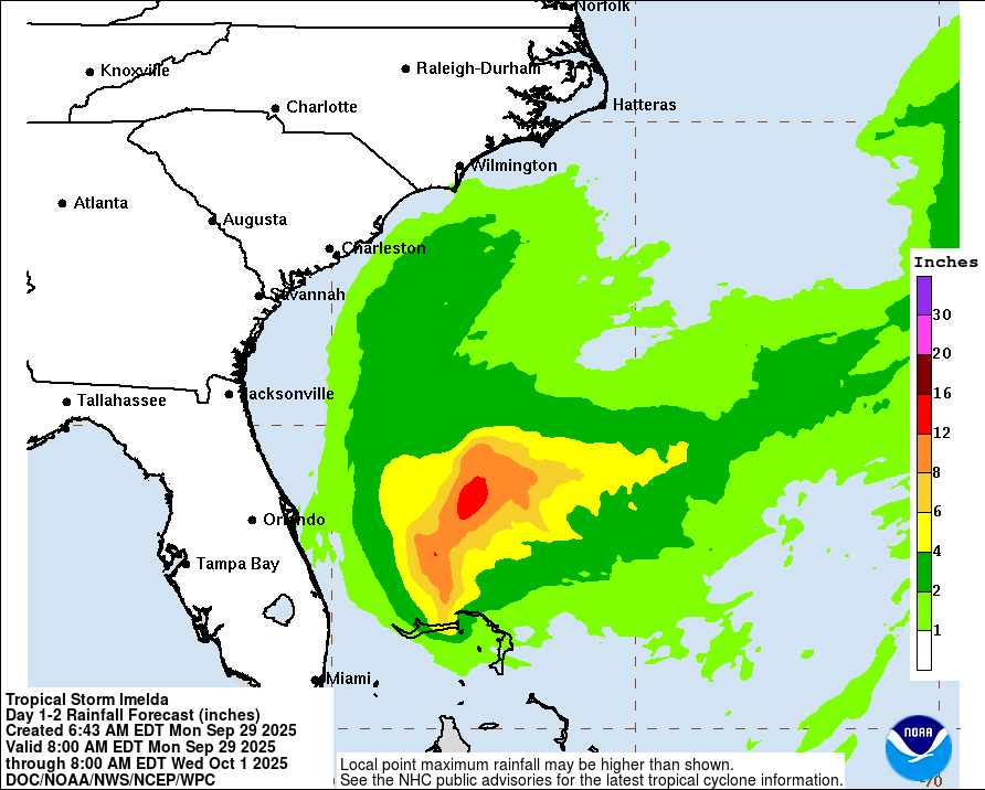
291454WPCQPF_sm
291454WPCERO_smflood
09L_tracks_latest
By PDC’s Senior Weather
Specialist Glenn James

The Pacific Disaster Center’s (PDC Global) Monday, September 29, 2025, Tropical Cyclone Activity Report…for the Atlantic Ocean, the Caribbean Sea, and the Gulf of America
Current Tropical Cyclones:
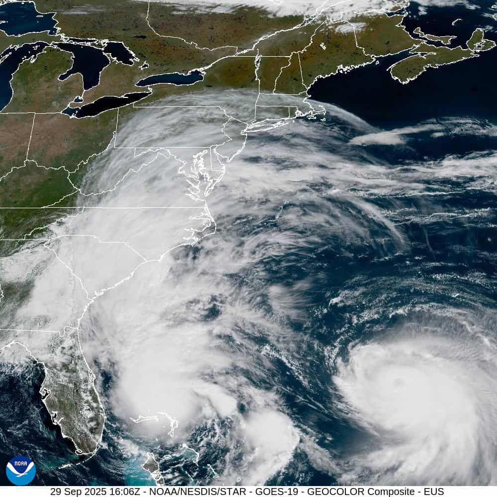
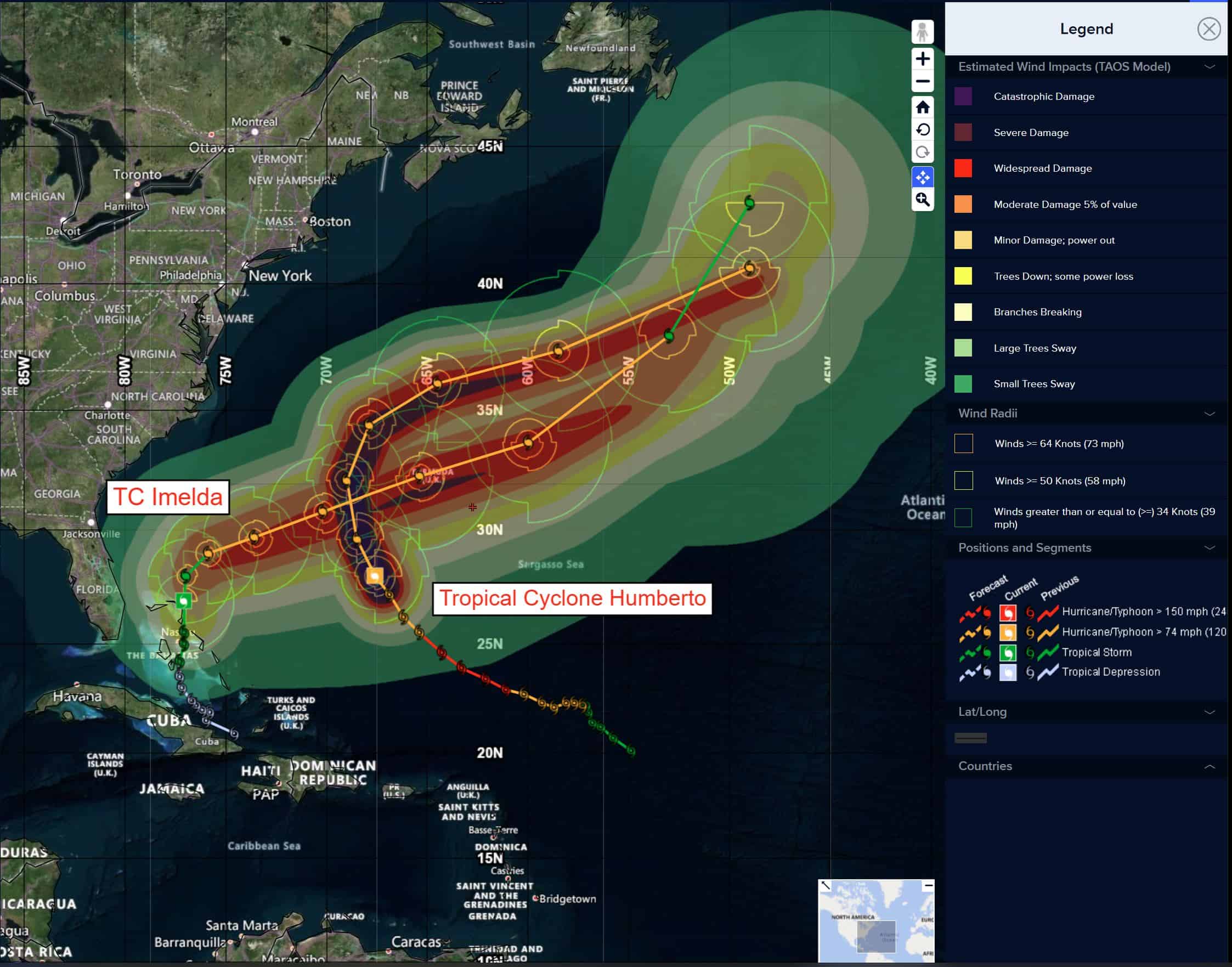
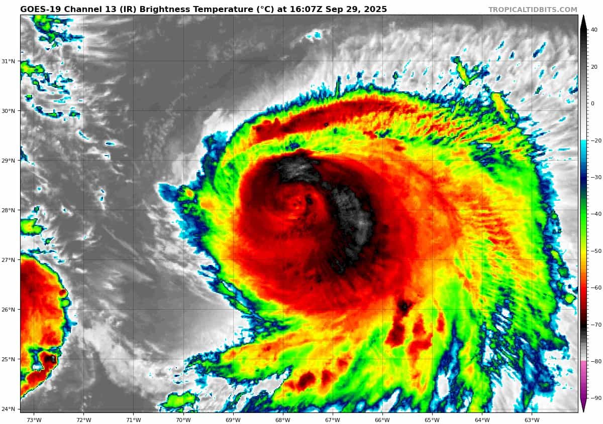
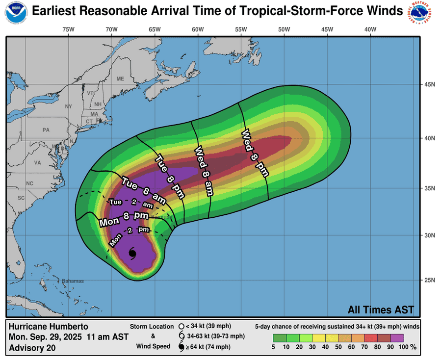
Tropical Cyclone 08L (Humberto)…is located about 295 miles southwest of Bermuda
Tropical Cyclone 09L (Imelda)…is located about 205 miles east-southeast of Cape Canaveral, Florida
Atlantic Ocean:
Tropical Cyclone 08L (Humberto)
HUMBERTO PRODUCING DANGEROUS SURF AND RIP CURRENTS FOR BERMUDA AND MOST OF THE U.S. EAST COAST…GUSTY WINDS AND HEAVY RAINFALL FROM OUTER RAINBANDS ARE POSSIBLE ACROSS BERMUDA TUESDAY INTO WEDNESDAY
According to the NHC advisory number 21
Humberto is moving toward the north-northwest near 13 mph (20 km/h). A gradual turn towards the north is expected over the next day or so. The hurricane is then forecast to turn and accelerate east-northeastward by late Tuesday or early Wednesday. On the forecast track, the center of Humberto will pass west, and then north of Bermuda on Tuesday and Wednesday.
Maximum sustained winds are near 140 mph (220 km/h) with higher gusts. Humberto is a category 4 hurricane on the Saffir-Simpson Hurricane Wind Scale. Weakening is forecast over the next several days, although Humberto is expected to remain a dangerous major hurricane into Tuesday.
Hurricane-force winds extend outward up to 70 miles (110 km) from the center and tropical-storm-force winds extend outward up to 185 miles (295 km). The estimated minimum central pressure is 942 mb (27.82 inches).
HAZARDS AFFECTING LAND SURF:
SURF: Swells generated by Humberto will continue to affect portions of the northern Leeward Islands, the Virgin Islands, Puerto Rico, and Bermuda through much of this week. Swells from Humberto will also affect the U.S. East Coast beginning today.
WIND: Tropical storm conditions are possible on Bermuda beginning Tuesday.
RAINFALL: Hurricane Humberto is expected to bring rainfall of 1 to 2 inches – 25 to 50 mm – to Bermuda Monday night through Tuesday
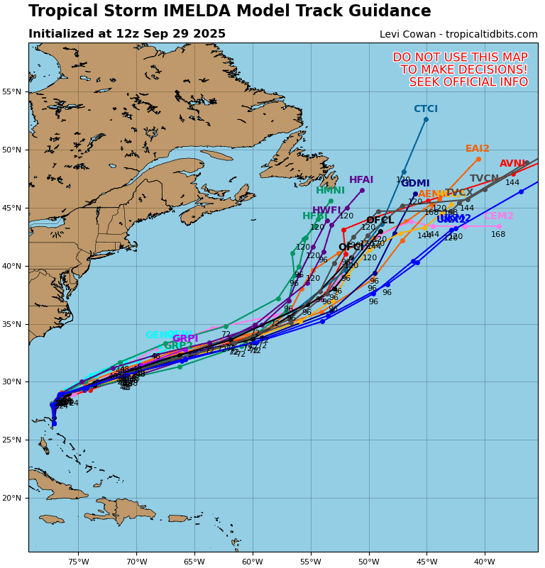
Tropical Cyclone 09L (Imelda)
IMELDA FORECAST TO BECOME A HURRICANE TOMORROW MORNING… …HURRICANE WATCH NOW IN EFFECT FOR ISLAND OF BERMUDA
Imelda is moving toward the north near 9 mph (15 km/h), and a general northward motion is expected to continue tonight. On Tuesday, Imelda is expected to turn sharply to the east-northeast and accelerate. On the forecast track, the center of the system is expected to start moving away from the northwestern Bahamas this afternoon and then turn east-northeastward, moving away from the southeastern U.S. but approaching the island of Bermuda on Wednesday. Maximum sustained winds have increased to near 65 mph (100 km/h) with higher gusts. Additional strengthening is forecast over the next several days, and Imelda is forecast to become a hurricane on Tuesday morning. Tropical-storm-force winds extend outward up to 175 miles (280 km) from the center. The estimated minimum central pressure is 986 mb (29.12 inches).
HAZARDS AFFECTING LAND
WIND: Tropical storm conditions are occuring in portions of the northwestern Bahamas and should continue through today.
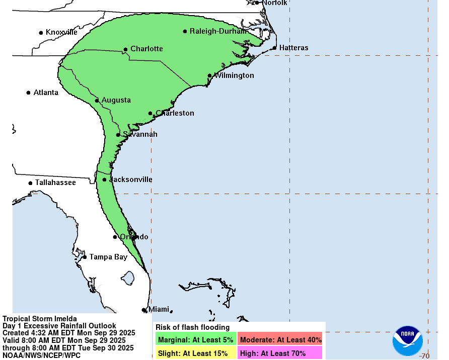
RAINFALL: Tropical Storm Imelda is expected to produce total rainfall of 4 to 8 inches across the northwest Bahamas through Tuesday. This rainfall will likely produce flash and urban flooding.
Storm total rainfall amounts of 1 to 2 inches with local maxima of 4 inches are expected through Tuesday across northeast Florida, coastal South Carolina, and coastal sections of southeast North Carolina. This rainfall could result in isolated flash and urban flooding.
As Imelda passes near Bermuda, 2 to 4 inches – 50 to 100 mm – of rainfall is expected from Wednesday into Thursday.
STORM SURGE: A storm surge will raise water levels by as much as 1 to 3 feet above ground level along the immediate coast in areas of onshore winds in the northwestern Bahamas. Near the coast, the surge will be accompanied by large waves.
Minor coastal flooding is possible in areas of onshore winds over the Southeastern U.S. coastline. The water could reach the following heights above ground somewhere in the indicated areas if the surge occurs over the next several high tide cycles…
Volusia/Brevard County Line, Florida to the South Santee River, South Carolina…1 to 2 ft
SURF: Swells generated by Tropical Storm Imelda and Hurricane Humberto are affecting the Bahamas and will spread to much of the east coast of the U.S. early this week. These swells are likely to cause life-threatening surf and rip current conditions.
Caribbean Sea: There are no active tropical cyclones
Tropical cyclone formation is not expected during the next 7-days.
Gulf of America: There are no active tropical cyclones
Tropical cyclone formation is not expected during the next 7-days.