
")
Current Snapshot
For all the latest updates visit: DisasterAWARE
1800×1080
atlantic
goes19_ir_08L_202509281515_lat24.2-lon-63.8
281436_earliest_reasonable_toa_34hum
08L_tracks_latest
goes19_ir_09L_202509281522_lat23.1-lon-77.3
281450_earliest_reasonable_toa_3409
09L_tracks_latest
By PDC’s Senior Weather
Specialist Glenn James

The Pacific Disaster Center’s (PDC Global) Sunday, September 28, 2025, Tropical Cyclone Activity Report…for the Atlantic Ocean, the Caribbean Sea, and the Gulf of America
Current Tropical Cyclones:
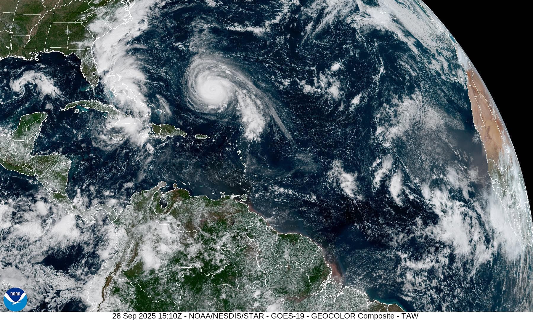
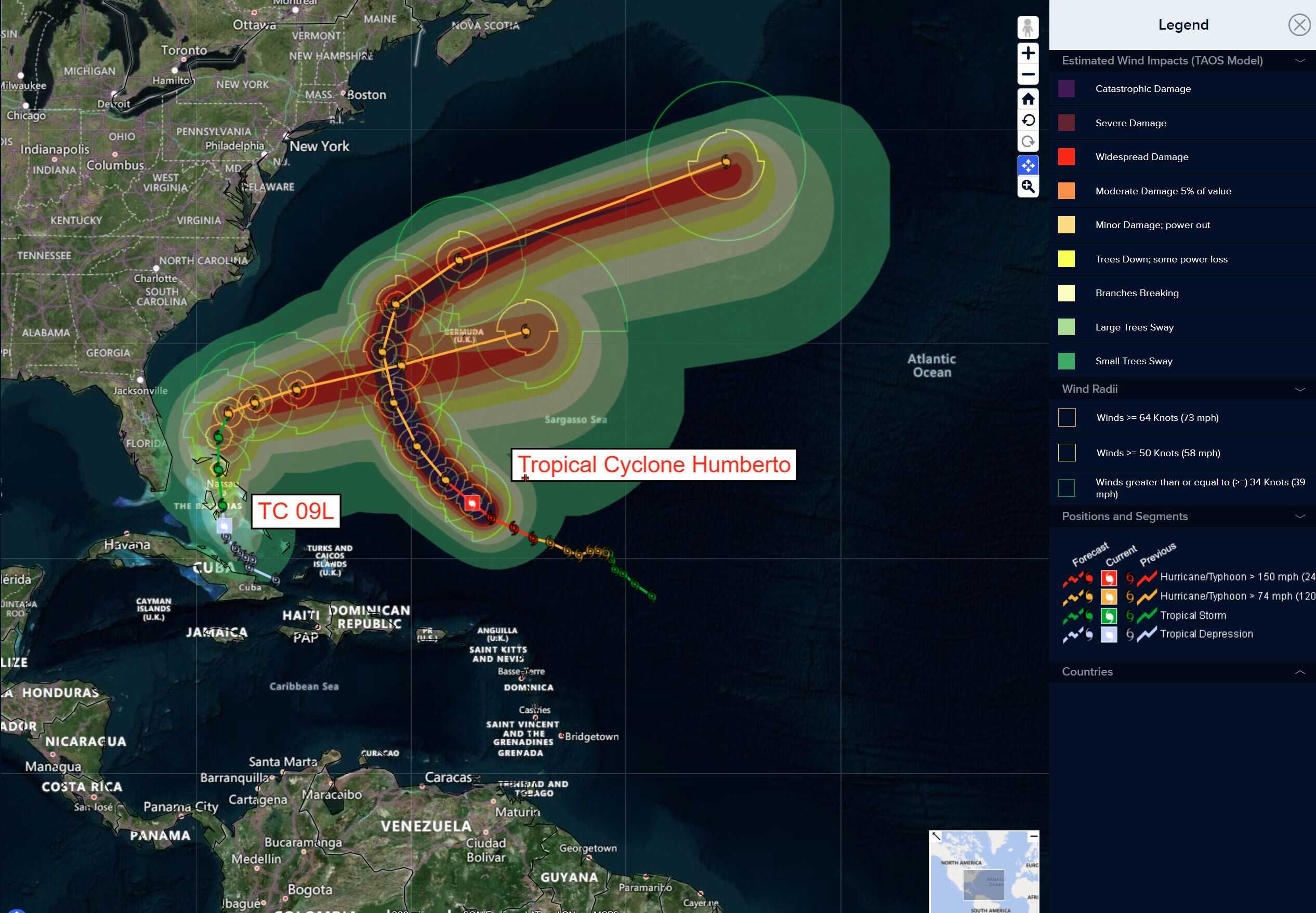
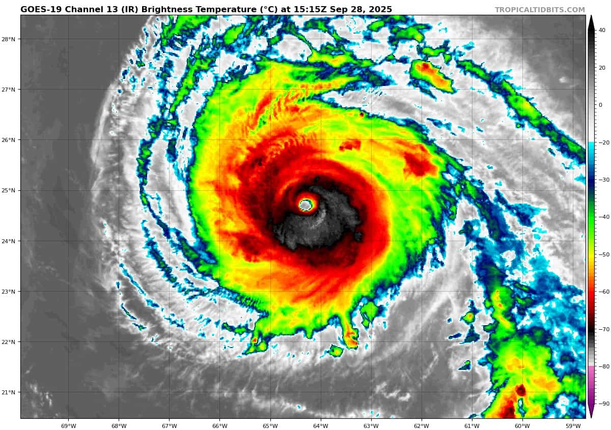
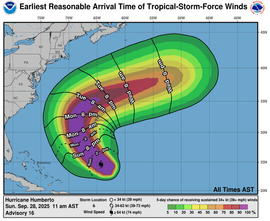
Tropical Cyclone 08L (Humberto)…is located about 400 south-southwest of Bermuda
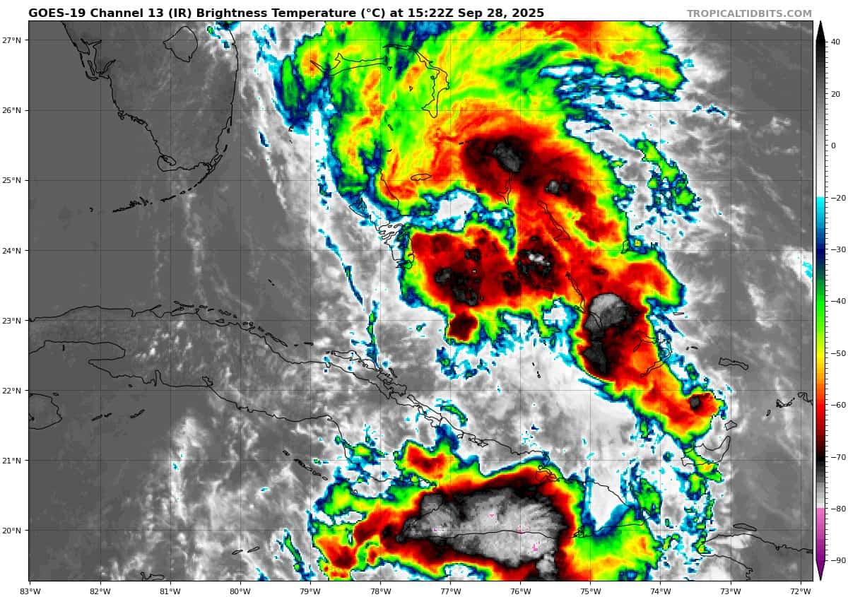
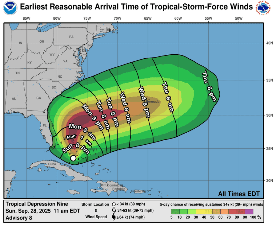
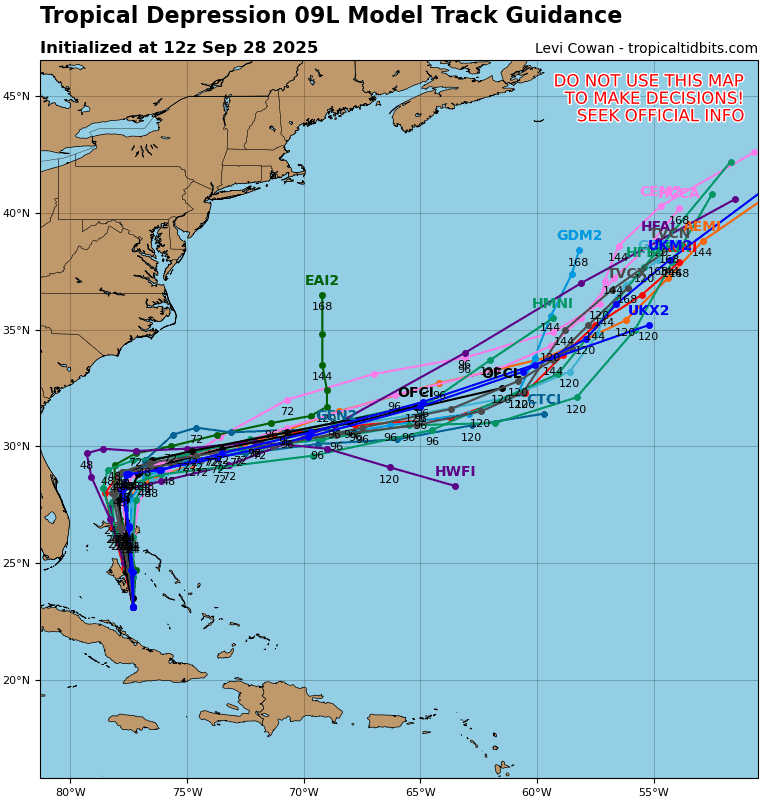
Tropical Cyclone 09L (Imelda)…is located about 95 west of the central Bahamas
Atlantic Ocean:
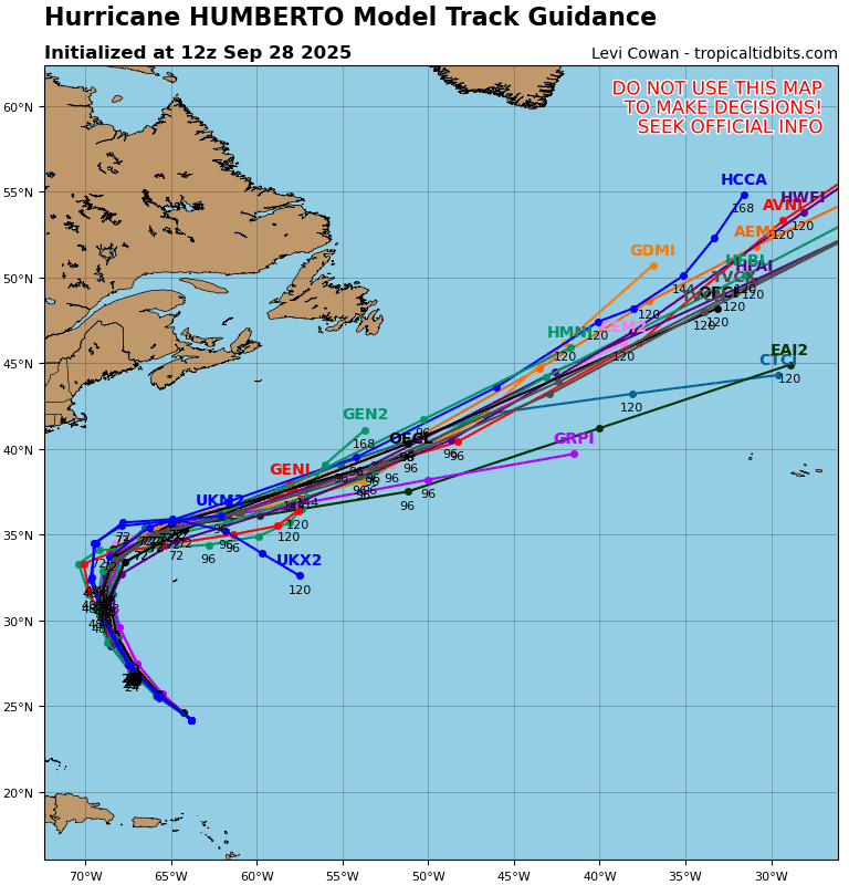
Tropical Cyclone 08L (Humberto)
CATEGORY 4 HUMBERTO WILL PRODUCE DANGEROUS SURF FOR BERMUDA AND MOST OF THE U.S. EAST COAST THIS WEEK
According to the NHC advisory number 18A
Humberto is moving toward the northwest near 14 mph (22 km/h). A gradual turn towards the north is expected over the next day or so. The hurricane is then forecast to turn and accelerate east-northeastward by late Tuesday or early Wednesday. On the forecast track, the center of Humberto will pass well west, and then north of Bermuda on Tuesday and Wednesday. Maximum sustained winds are near 140 mph (220 km/h) with higher gusts. Humberto is a category 4 hurricane on the Saffir-Simpson Hurricane Wind Scale. Fluctuations in intensity are possible during the next day or so. Gradual weakening is forecast after that, but Humberto is expected to remain a dangerous major hurricane for another couple of days. Hurricane-force winds extend outward up to 60 miles (95 km) from the center and tropical-storm-force winds extend outward up to 185 miles (295 km). The estimated minimum central pressure is 928 mb (27.41 inches).
HAZARDS AFFECTING LAND SURF:
SURF: Swells generated by Humberto will continue to affect portions of the northern Leeward Islands, the Virgin Islands, Puerto Rico, and Bermuda through much of this week. Swells from Humberto will also affect the U.S. East Coast beginning Monday. These swells are likely to cause life-threatening surf and rip current conditions.
Tropical Cyclone 09L (Imelda)
IMELDA GRADUALLY STRENGTHENING
According to the NHC advisory number 10A
Imelda is moving toward the north near 8 mph (13 km/h), and a generally northward motion is expected to continue today. On Tuesday, Imelda is expected to turn sharply to the east-northeast. On the forecast track, the center of the system is expected to move across the northwestern Bahamas today and then turn east-northeastward, moving away from the southeastern U.S. by the middle part of this week. Maximum sustained winds are near 45 mph (75 km/h) with higher gusts. Strengthening is expected during the next few days, and Imelda is forecast to become a hurricane by Tuesday. Tropical-storm-force winds extend outward up to 175 miles (280 km), primarily east of the center. The estimated minimum central pressure is 996 mb (29.42 inches) based on Air Force Reserve reconnaissance dropsonde data.
HAZARDS AFFECTING LAND
WIND: Tropical storm conditions are expected in the central Bahamas beginning later today and in the northwestern Bahamas late this afternoon. Tropical storm conditions are possible in the watch area along the east coast of Florida on Monday.
RAINFALL: Tropical Depression Nine is expected to produce additional rainfall of 2 to 6 inches across eastern Cuba and 6 to 12 inches across the northwest Bahamas through Tuesday. This rainfall will likely produce flash and urban flooding. Mudslides are also possible in areas of higher terrain across eastern Cuba.
Storm total rainfall amounts of 2 to 4 inches with local maxima of 7 inches are expected into Wednesday morning across portions of the coastal Carolinas. This rainfall could result in flash, urban, and isolated, minor river flooding. Changes in the forecast track could result in further adjustments to these rainfall totals.
STORM SURGE: A storm surge will raise water levels by as much as 1 to 3 feet above ground level along the immediate coast in areas of onshore winds in the northwestern Bahamas. Near the coast, the surge will be accompanied by large waves.
Minor coastal flooding is possible in areas of onshore winds over the Southeastern U.S. coastline. The water could reach the following heights above ground somewhere in the indicated areas if the surge occurs over the next several high tide cycles…
Volusia/Brevard County Line, Florida to the South Santee River, South Carolina…1 to 2 ft
SURF: Swells generated by this system and Hurricane Humberto will affect portions of the Bahamas this weekend, and spread to much of the east coast of the U.S. early this week. These swells are likely to cause life-threatening surf and rip current conditions.
Caribbean Sea: There are no active tropical cyclones
Tropical cyclone formation is not expected during the next 7-days.
Gulf of America: There are no active tropical cyclones
Tropical cyclone formation is not expected during the next 7-days.