
")
Current Snapshot
For all the latest updates visit: DisasterAWARE

1800x1080e
7

mun
04W_031200sair

04W_tracks_latest
By PDC’s Senior Weather
Specialist Glenn James

The Pacific Disaster Center’s (PDC Global) Thursday, July 3, 2025, Tropical Cyclone Activity Report…for the Pacific Ocean, the Indian Ocean, and adjacent Seas
Current Tropical Cyclones:
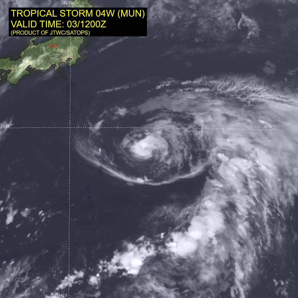
Tropical Cyclone 04W (Mun)…is located about 428 NM southeast of Yokosuka, Japan
Tropical Cyclone 05W…is located about 296 NM east-southeast of Hong Kong
Northeast Pacific Ocean: There are no Tropical Cyclones
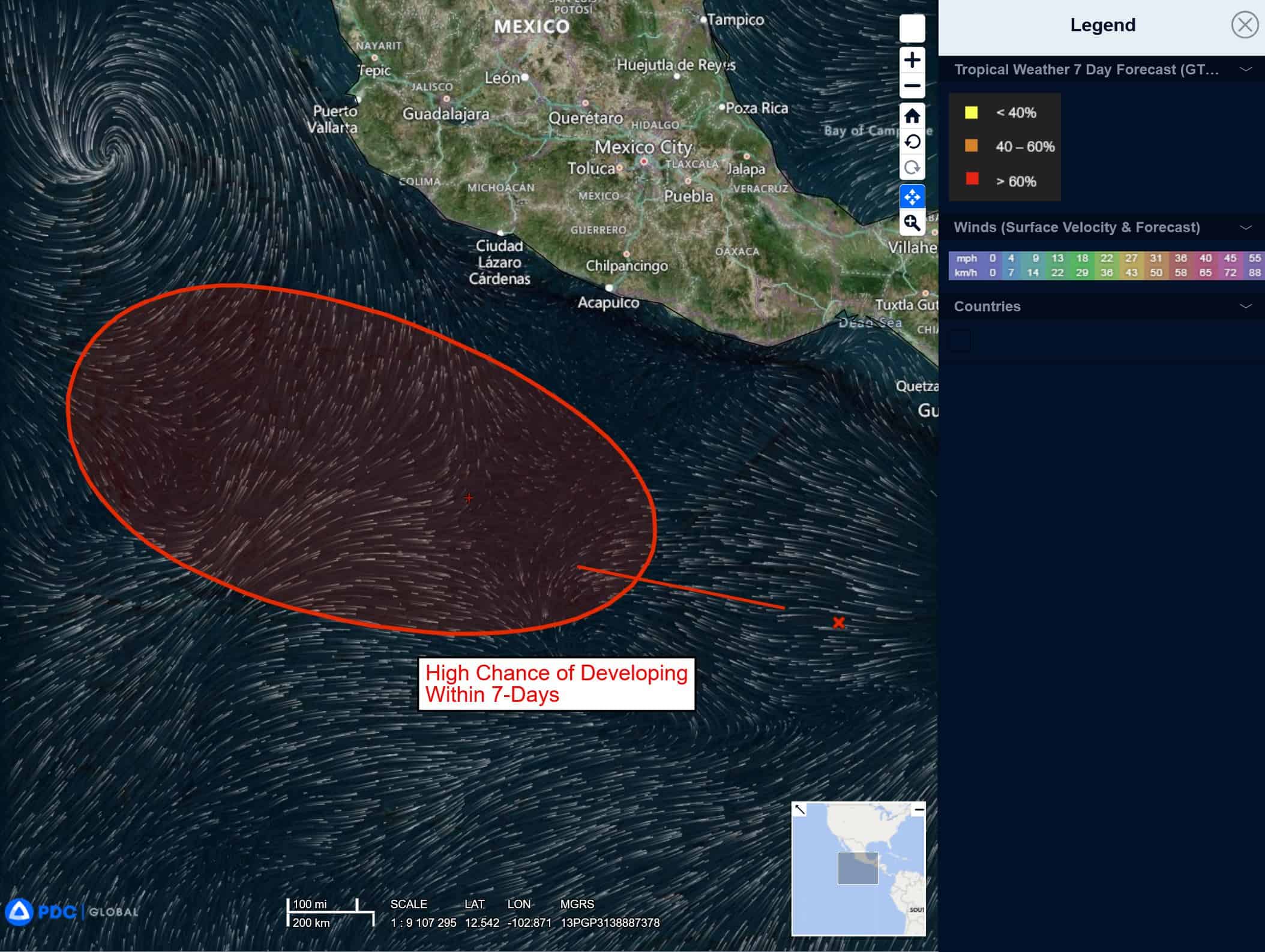
South of Southern Mexico:
>>> An area of disturbed weather associated with a tropical wave is producing disorganized showers and thunderstorms several hundred miles south-southwest of the Gulf of Tehuantepec. Gradual development of this system is expected during the next few days, and a tropical depression is likely to form over the weekend or early next week while it moves generally west-northwestward well off the coast of Mexico.
* Formation chance through 48 hours…medium…40 percent
* Formation chance through 7 days…high…80 percent
Central Pacific Ocean: There are no Tropical Cyclones
Tropical cyclone formation is not expected during the next 7-days.
Western Pacific, Indian Ocean, and adjacent Seas:
Western Pacific
Tropical Cyclone 04W (Mun)
According to the JTWC Warning number 10, sustained winds are 55 knots with gusts to 70 knots
Upper-level outflow has improved quickly, which indicate the upper-low previously over the center has weakened. Additionally, the system has maintained strong eastward, diffluent outflow enhanced
by a jet stream to the northeast, with a moistening core. Consequently, animated enhanced infrared satellite imagery depicts a compact core and improved central convection and organization, with the system flirting with a developing weak eye over the past few hours.
Two recent images also provide solid evidence that ts 04W is consolidating quickly: a color composite image, depicting a microwave eye feature, and a sar image, depicting a symmetric center with a band of 50-60 knot winds surrounding the center. The sar image does show maximum winds as high as 72 knots over the northeast quadrant but these winds appear to be too high.
TS 04W is forecast to track northward through 24 hours along the western periphery of the str. After 24 hours, the system is expected to turn sharply northeastward as the str reorients in response to an approaching shortwave trough over northern Japan. The shortwave trough will rapidly propagate eastward allowing the str to rebuild, which will drive the system on a more poleward trajectory through 120 hours.
Environmental conditions are improving, which will support a short period of intensification, driven largely by the robust eastward outflow, with a peak intensity of 70 knots forecast by 24 hours. Sea surface temperature values will cool steadily after 24 hours, with values decreasing by 48 hours then even cooler after 72 hours.
After 60 hours, environmental conditions will degrade quickly, with increasing vertical wind shear (vws) of 35-40 knots, which will lead to rapid weakening. The system is expected to transition to a subtropical system near 120 hours.
Tropical Cyclone 05W
According to the JTWC Warning number 1, sustained winds are 25 knots with gusts to 35 knots