
")
Current Snapshot
For all the latest updates visit: DisasterAWARE
1800x1080hhhhhh
erin

1000×1000
goes19_ir_05L_202508211552_lat34.9-lon-71.7
211443_earliest_reasonable_toa_34
211443WPCQPF_sm
211443_peak_surge

22222
7
goes19_ir_99L_202508211545_lat11.3-lon-33.5

99L_tracks_latest
By PDC’s Senior Weather
Specialist Glenn James

The Pacific Disaster Center’s (PDC Global) Thursday, August 21, 2025, Tropical Cyclone Activity Report…for the Atlantic Ocean, the Caribbean Sea, and the Gulf of America
Current Tropical Cyclones:
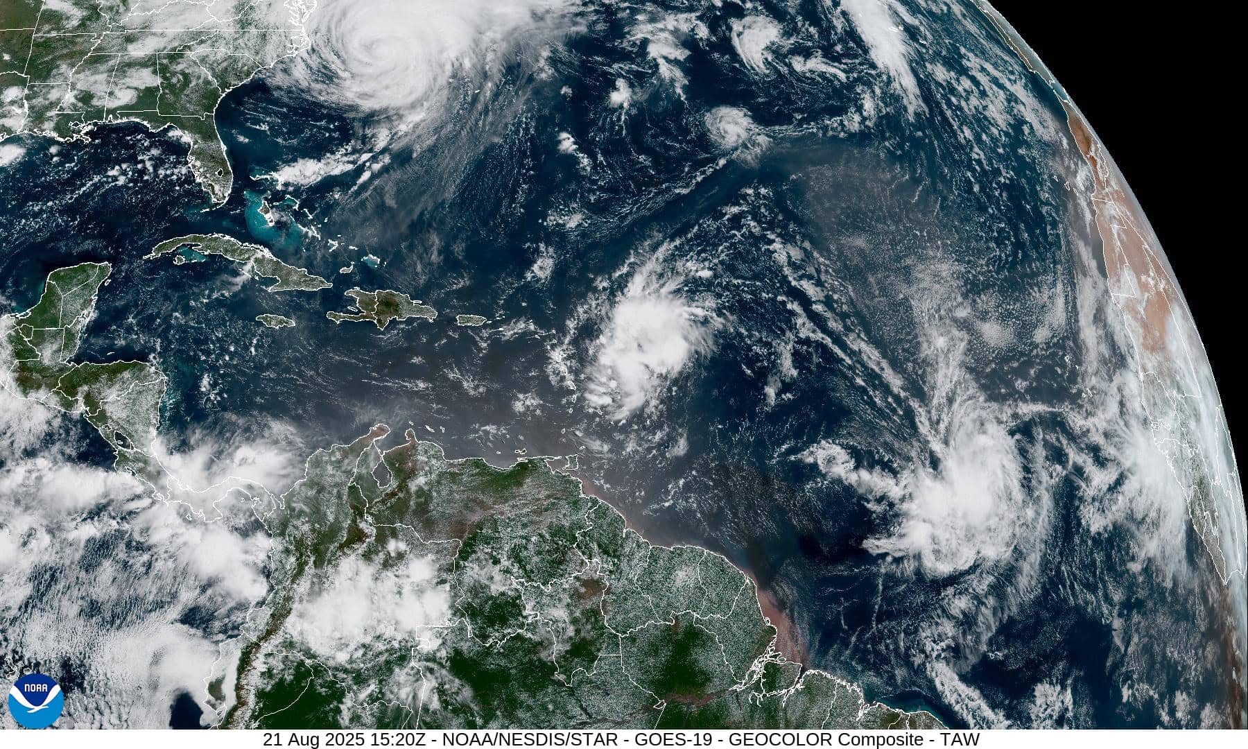
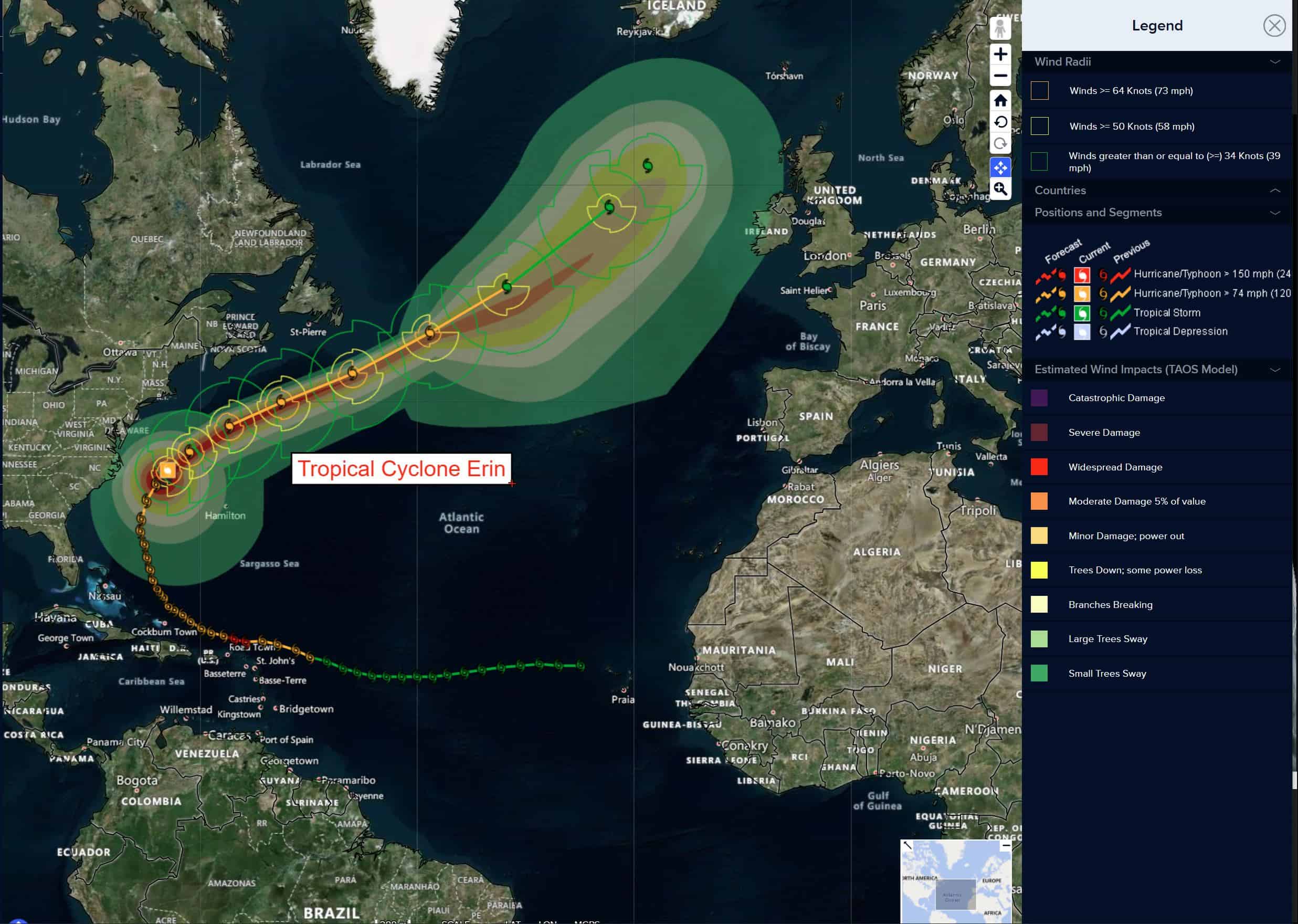
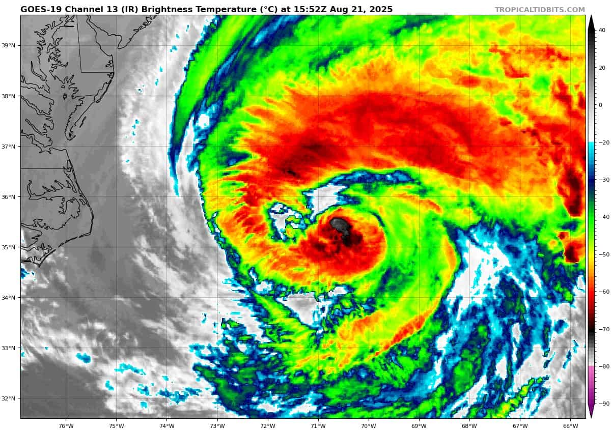
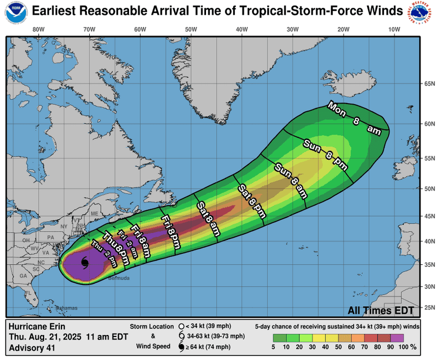
Tropical Cyclone Erin…is located about 490 miles south-southwest of Halifax, Nova Scotica
Atlantic Ocean
Tropical Cyclone Erin
TROPICAL-STORM-FORCE WIND GUSTS OCCURRING ON BERMUDA AND NANTUCKET…SWIMMING AT MOST U.S. EAST COAST BEACHES IS LIKELY TO REMAIN DANGEROUS FOR A COUPLE MORE DAYS
According to the NHC advisory number 43A
Erin is moving toward the northeast near 22 mph (35 km/h). A faster northeastward to east-northeastward motion is expected during the next couple of days. On the forecast track, the center of Erin will move over the western Atlantic between New England and Bermuda through this morning, and then pass south of Atlantic Canada today and Saturday. Maximum sustained winds are near 90 mph (150 km/h) with higher gusts. Gradual weakening is forecast during the next couple of days, but Erin is still expected to be producing hurricane-force winds when it becomes post-tropical on Saturday. Erin remains a very large hurricane. Hurricane-force winds extend outward up to 125 miles (205 km) from the center and tropical-storm-force winds extend outward up to 370 miles (595 km). A wind gust to 51 mph (82 km/h) was recently reported at the L. F. Wade International Airport on Bermuda, and a gust to 47 mph (76 km/h) was measured at the airport on Nantucket, Massachusetts.
HAZARDS AFFECTING LAND
WIND: Tropical storm conditions will continue to affect portions of the North Carolina Outer Banks and the Virginia coastline for the next several hours. Elsewhere along the mid-Atlantic and southern New England coast, wind gusts to tropical storm force are likely today through early Friday. Tropical storm conditions are possible on Bermuda this afternoon through early Friday. Gusts to gale force are possible along portions of the coast of Nova Scotia on Friday and the Avalon Peninsula of Newfoundland on Saturday.
SURF: Swells generated by Erin will affect the Bahamas, Bermuda, the east coast of the United States, and Atlantic Canada during the next several days. These rough ocean conditions are expected to cause life-threatening surf and rip currents.
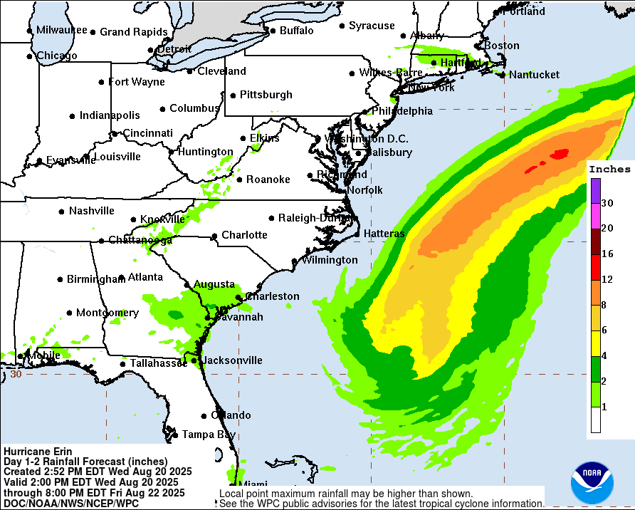
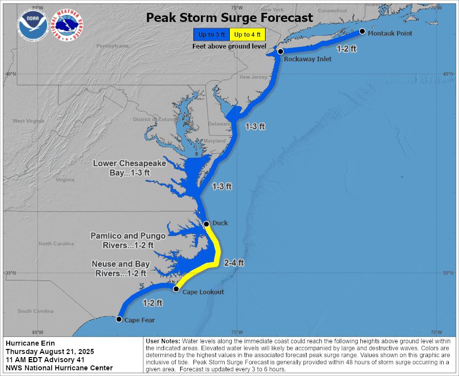
STORM SURGE: The combination of a dangerous storm surge and the tide will cause normally dry areas near the coast to be flooded by rising waters moving inland from the shoreline. The water could reach the following heights above ground somewhere in the indicated areas if the peak surge occurs at the time of high tide…
Cape Lookout to Duck, North Carolina…2 to 4 ft
The deepest water will occur along the immediate coast where the surge will be accompanied by large and dangerous waves. Surge-related flooding depends on the relative timing of the surge and the tidal cycle, and can vary greatly over short distances.
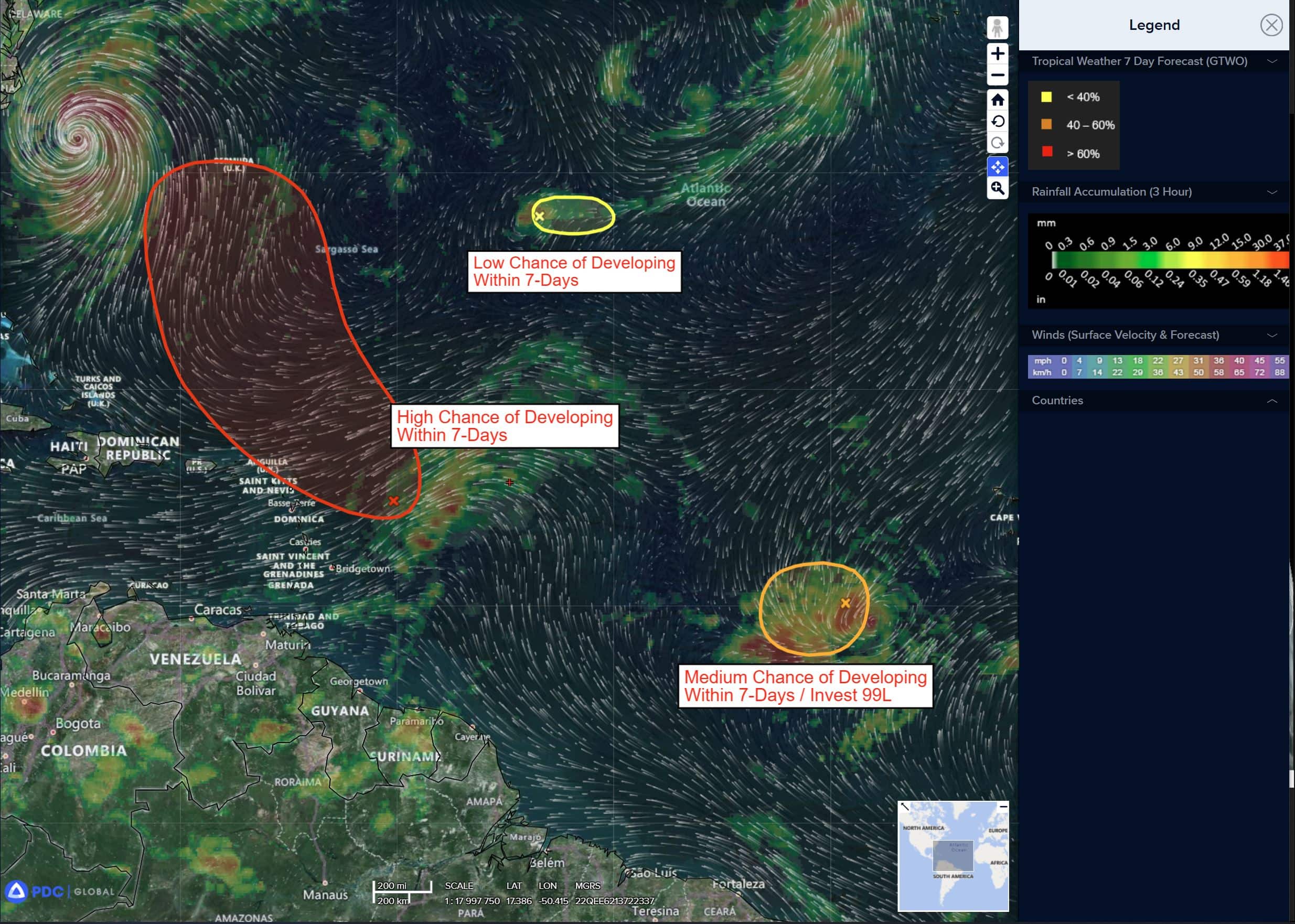
Near the Leeward Islands
Invest 90L
>>> An area of disorganized showers and thunderstorms associated with a tropical wave is located a couple hundred miles east-northeast of the northern Leeward Islands. Environmental conditions appear conducive for further development of this system, and a tropical depression is likely to form this weekend while it moves northwestward and then northward, in between the Lesser Antilles and Bermuda.
* Formation chance through 48 hours…high…70 percent
* Formation chance through 7 days…high 80 percent
Central Tropical Atlantic
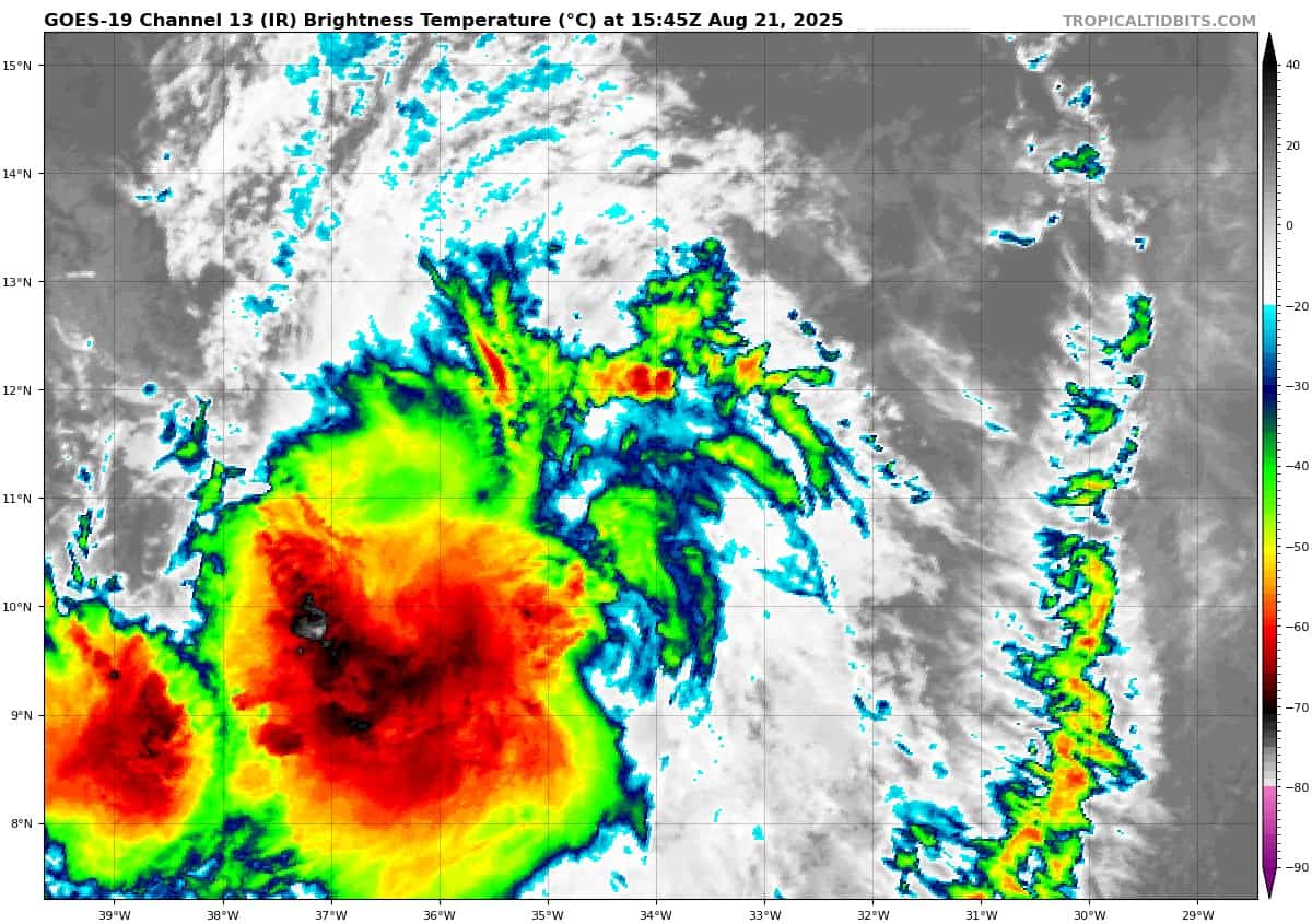
Invest 99L
>>> Showers and thunderstorms associated with a tropical wave located about a thousand miles west-southwest of the Cabo Verde Islands remain well organized. This system could become a tropical depression at any time, but the latest satellite-derived wind data indicate that the system does not have a well-defined circulation center. The system is expected to move into a less conducive environment later today through Saturday, but could reach a slightly more favorable environment again late this weekend into early next week as it moves westward at 10 to 15 mph over the central tropical Atlantic and approaches the Lesser Antilles.
* Formation chance through 48 hours…medium…50 percent
* Formation chance through 7 days…medium…60 percent
Central Subtropical Atlantic
>>> A small area of low pressure located well southwest of the Azores is moving through a dry environment and only producing occasional showers. Upper-level winds appear unfavorable, and development chances are decreasing. The weak low is likely to dissipate over the next day or so as it moves little.
* Formation chance through 48 hours…low…10 percent
* Formation chance through 7 days…low…10 percent
Caribbean Sea: There are no active tropical cyclones
Tropical cyclone formation is not expected during the next 7-days.
Gulf of America: There are no active tropical cyclones
Tropical cyclone formation is not expected during the next 7-days.