
")
Current Snapshot
For all the latest updates visit: DisasterAWARE
erin

1000×1000
201454_earliest_reasonable_toa_34
201454WPCQPF_sm
05L_tracks_latest
2
7

1800×1080
goes19_ir_99L_202508201425_lat11.5-lon-29.1

99L_tracks_latest
By PDC’s Senior Weather
Specialist Glenn James

The Pacific Disaster Center’s (PDC Global) Wednesday, August 20, 2025, Tropical Cyclone Activity Report…for the Atlantic Ocean, the Caribbean Sea, and the Gulf of America
Current Tropical Cyclones:
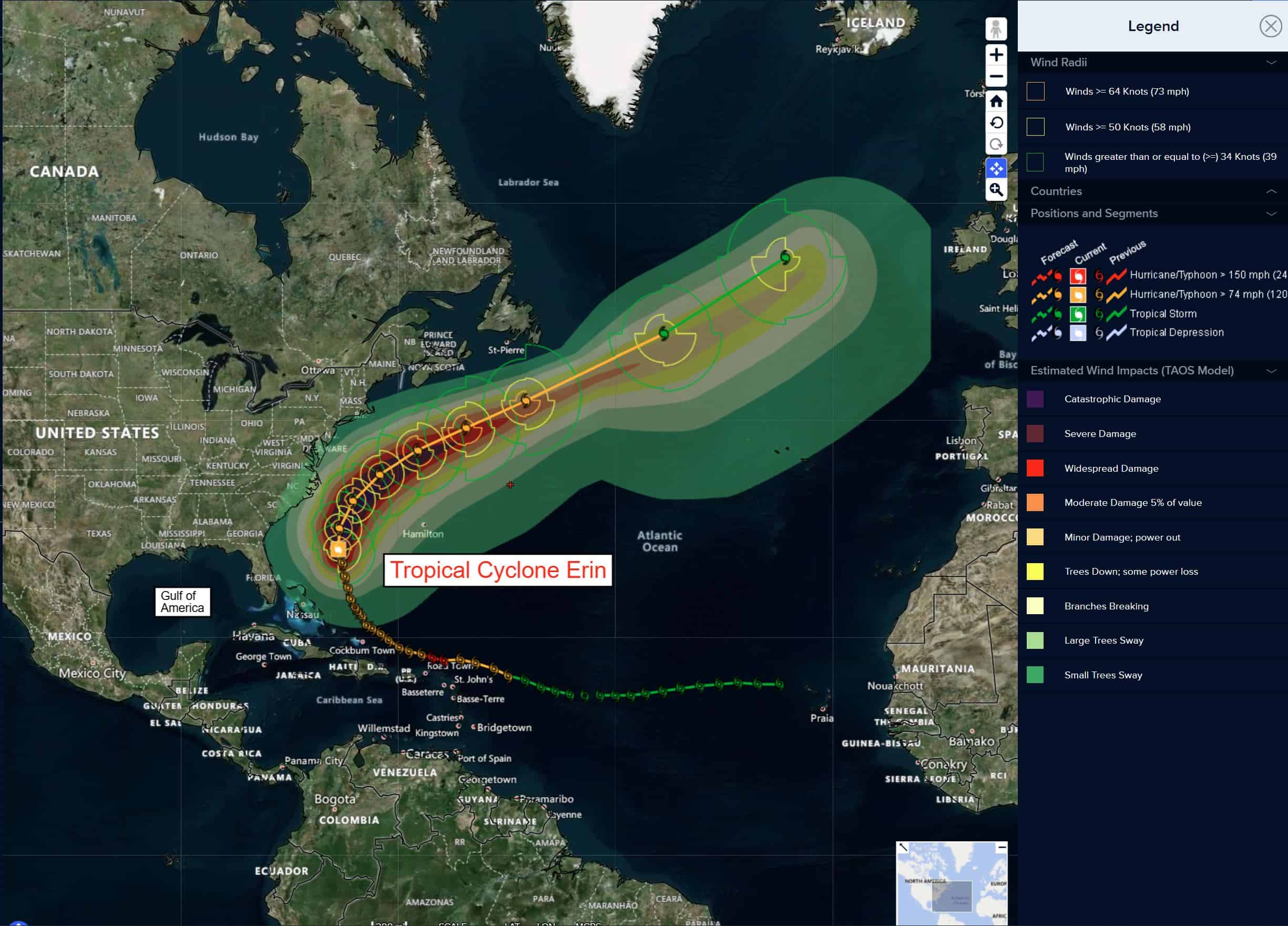
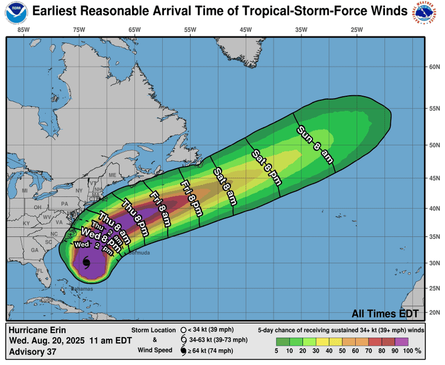
Tropical Cyclone Erin…is located about 200 miles southeast of Cape Hatteras, North Carolina
Atlantic Ocean
Tropical Cyclone Erin
TROPICAL STORM CONDITIONS OCCURRING ON THE NORTH CAROLINA OUTER BANKS AS ERIN TURNS TO THE NORTH-NORTHEAST…BEACHGOERS ARE CAUTIONED AGAINST SWIMMING AT MOST U.S. EAST COAST BEACHES DUE TO LIFE-THREATENING SURF AND RIP CURRENTS
According to the NHC advisory number 39A
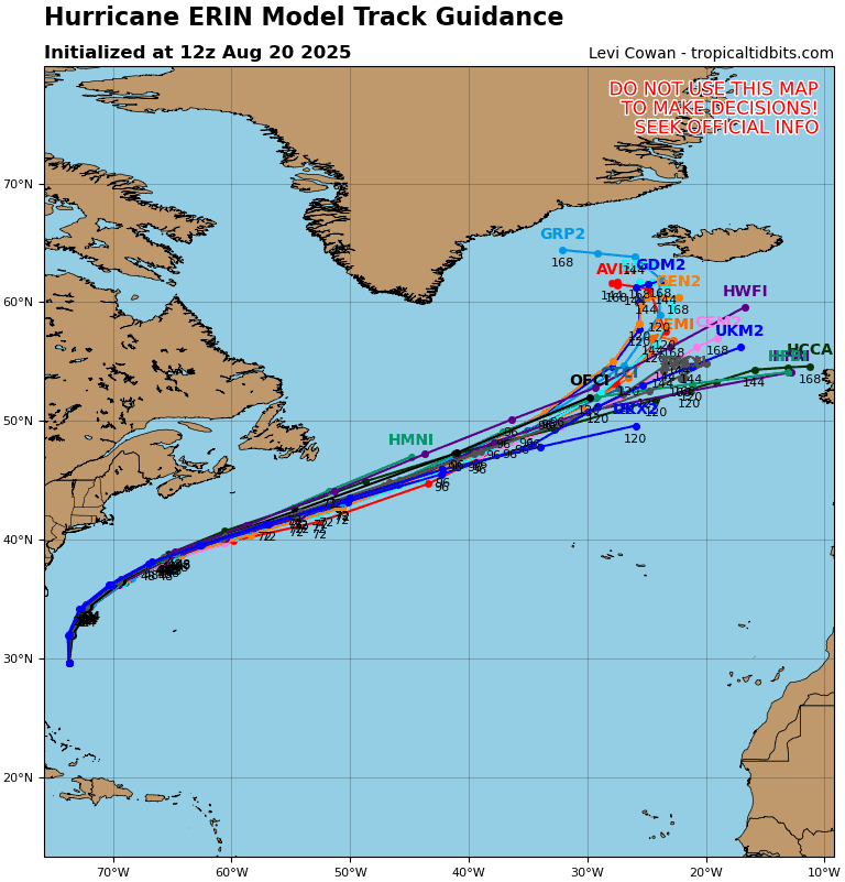
Erin is now moving toward the north-northeast near 17 mph (28 km/h). A faster motion toward the northeast and east-northeast is expected later today and on Friday. On the forecast track, the center of Erin will move over the western Atlantic between the U.S. east coast and Bermuda today through early Friday, and then pass south of Atlantic Canada Friday and Saturday. Reports from an Air Force Reserve reconnaissance aircraft indicate that maximum sustained winds are near 105 mph (165 km/h) with higher gusts. Gradual weakening is expected over the next several days, and Erin is likely to become post-tropical by Saturday. Erin is a large hurricane. Hurricane-force winds extend outward up to 105 miles (165 km) from the center and tropical-storm-force winds extend outward up to 300 miles (480 km). A sustained wind of 40 mph (65 km/h) and a gust to 46 mph (74 km/h) were recently reported at the U.S. Coast Guard Station Hatteras.
HAZARDS AFFECTING LAND
WIND: Tropical storm conditions are occurring over portions of the North Carolina Outer Banks and will spread northward along the Virginia coastline later this morning. Elsewhere along the mid-Atlantic and southern New England coast, wind gusts to tropical storm force are likely today through early Friday. Tropical storm conditions are possible on Bermuda later today through early Friday. Gale conditions are possible along portions of the coast of Nova Scotia beginning early Friday.
SURF: Swells generated by Erin will affect the Bahamas, Bermuda, the east coast of the United States, and Atlantic Canada during the next several days. These rough ocean conditions are expected to cause life-threatening surf and rip currents.
STORM SURGE: The combination of a dangerous storm surge and the tide will cause normally dry areas near the coast to be flooded by rising waters moving inland from the shoreline. The water could reach the following heights above ground somewhere in the indicated areas if the peak surge occurs at the time of high tide…
Cape Lookout to Duck, North Carolina…2 to 4 ft
The deepest water will occur along the immediate coast where the surge will be accompanied by large and dangerous waves. Surge-related flooding depends on the relative timing of the surge and the tidal cycle, and can vary greatly over short distances.
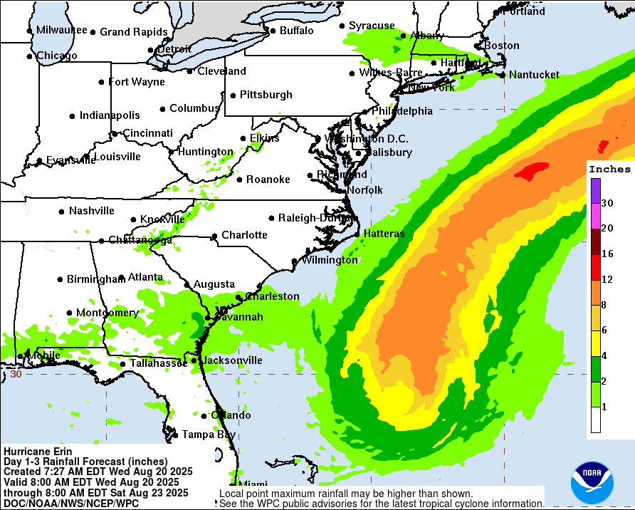
RAINFALL: The outer bands of Erin may bring up to 1 inch of rainfall to the Outer Banks of North Carolina today.
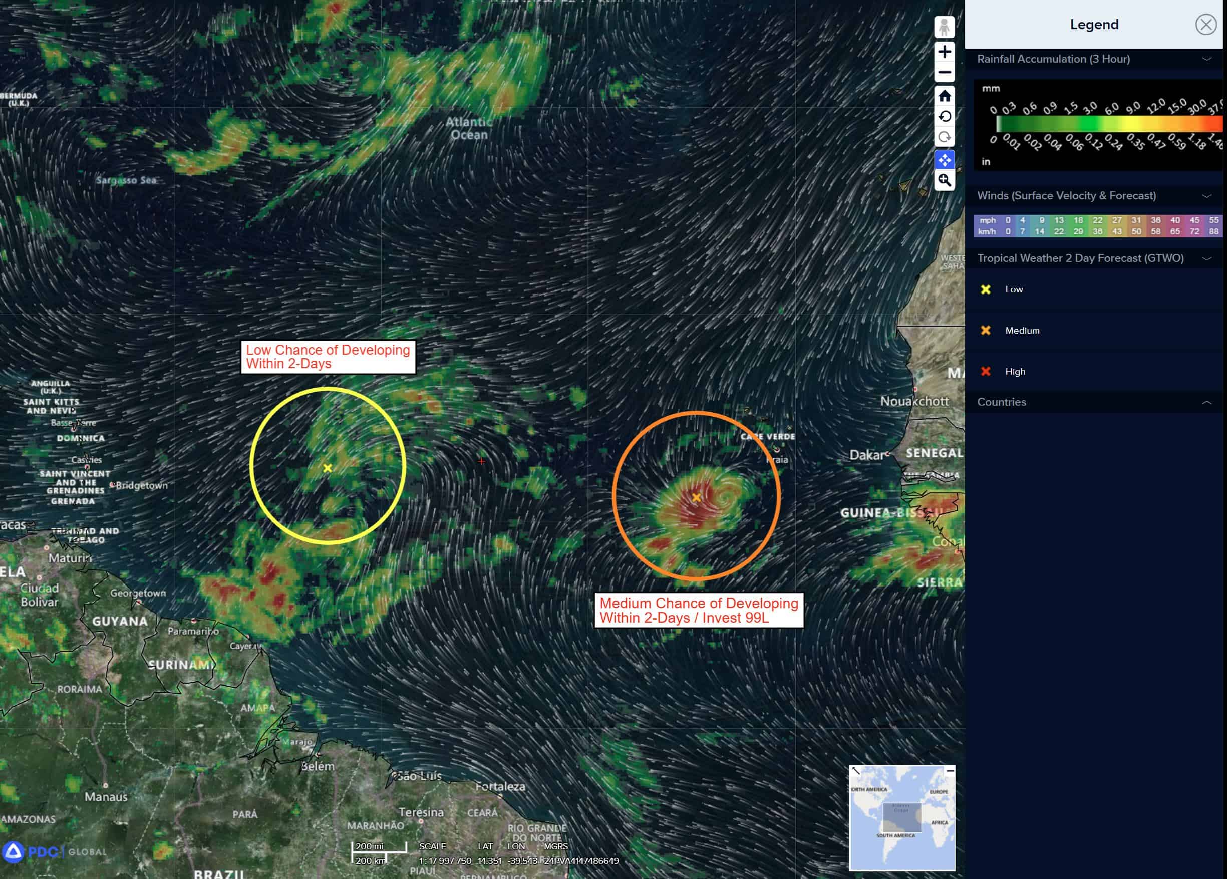
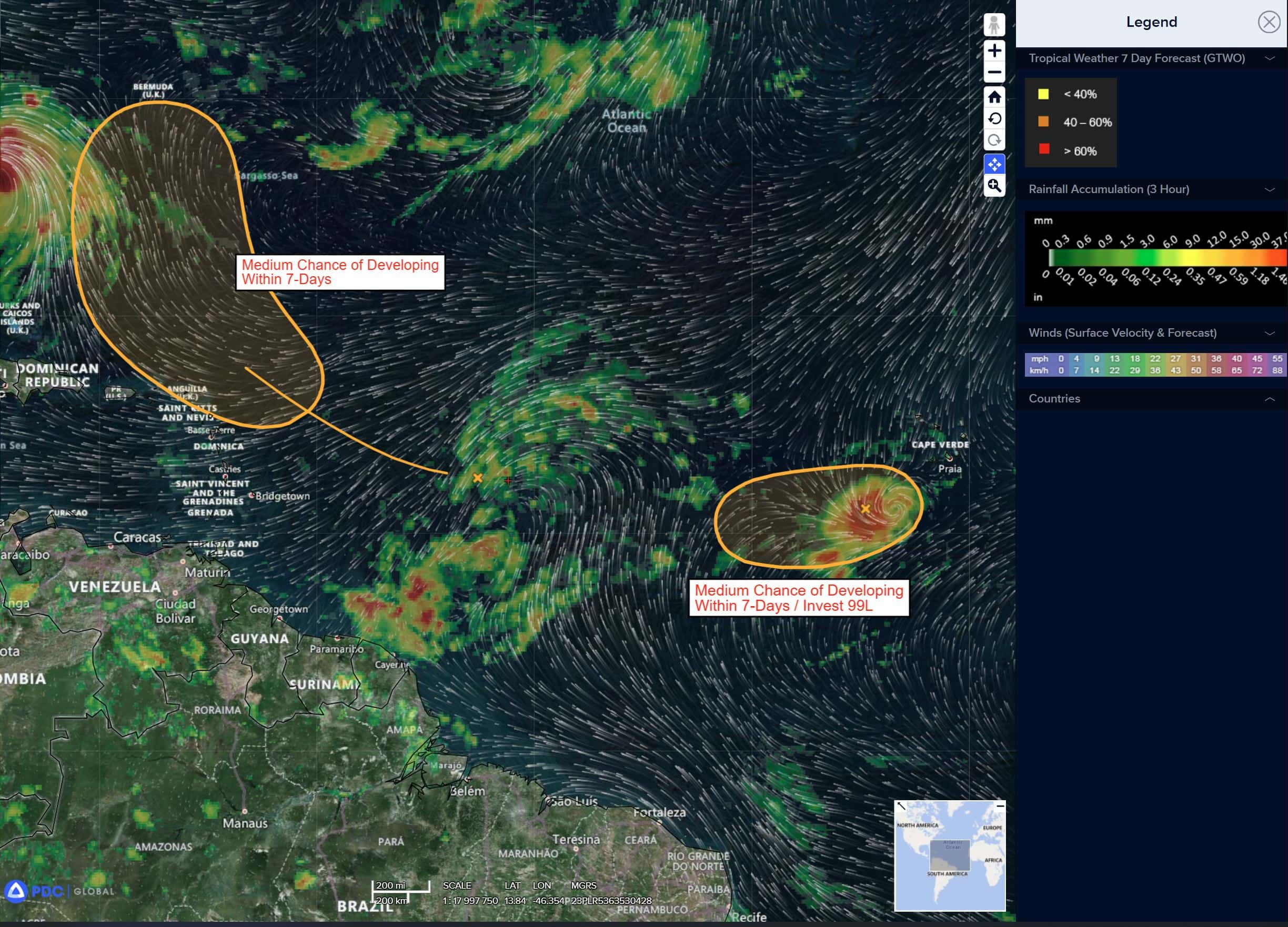
Near the Leeward Islands in the Tropical Atlantic
>>> Shower and thunderstorm activity has become a bit more concentrated in association with a tropical wave located a few hundred miles east of the Leeward Islands. Environmental conditions appear conducive for further development of this system, and a tropical depression is likely to form this weekend while it moves near or to the north of the northern Leeward Islands.
* Formation chance through 48 hours…low…30 percent
* Formation chance through 7 days…high 70 percent
Eastern Tropical Atlantic
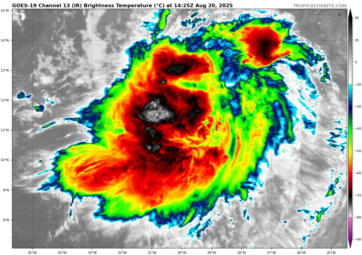
Invest 99L
>>> Showers and thunderstorms associated with a tropical wave located several hundred miles west-southwest of the Cabo Verde Islands are starting to show some signs of organization. However, recent satellite-derived wind data depict that the system does not have a well-defined center. Environmental conditions appear marginally favorable for additional development over the next day or so while the system moves west-southwestward at around 15 mph, and a short-lived tropical depression could form. By the end of the week, environmental conditions are expected to become unfavorable for further development.
* Formation chance through 48 hours…medium…40 percent
* Formation chance through 7 days…medium…40 percent
Caribbean Sea: There are no active tropical cyclones
Tropical cyclone formation is not expected during the next 7-days.
Gulf of America: There are no active tropical cyclones
Tropical cyclone formation is not expected during the next 7-days.