
")
Current Snapshot
For all the latest updates visit: DisasterAWARE
erin
1000×1000
GOES19-CAR-13-1000×1000
191453_earliest_reasonable_toa_34
191453WPCQPF_sm
2
7

1800×1080

99L_tracks_latest
By PDC’s Senior Weather
Specialist Glenn James

The Pacific Disaster Center’s (PDC Global) Tuesday, August 19, 2025, Tropical Cyclone Activity Report…for the Atlantic Ocean, the Caribbean Sea, and the Gulf of America
Current Tropical Cyclones:
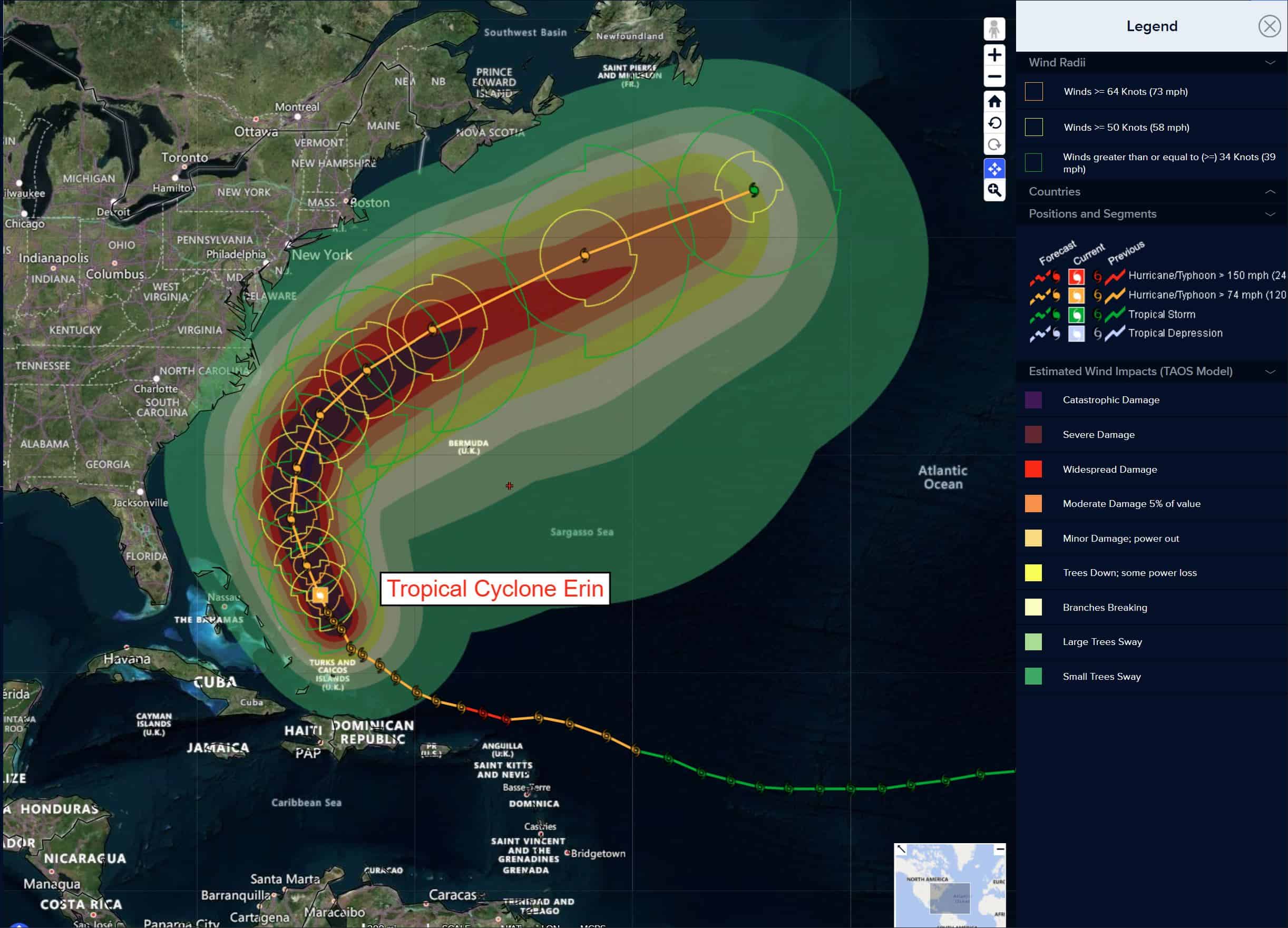
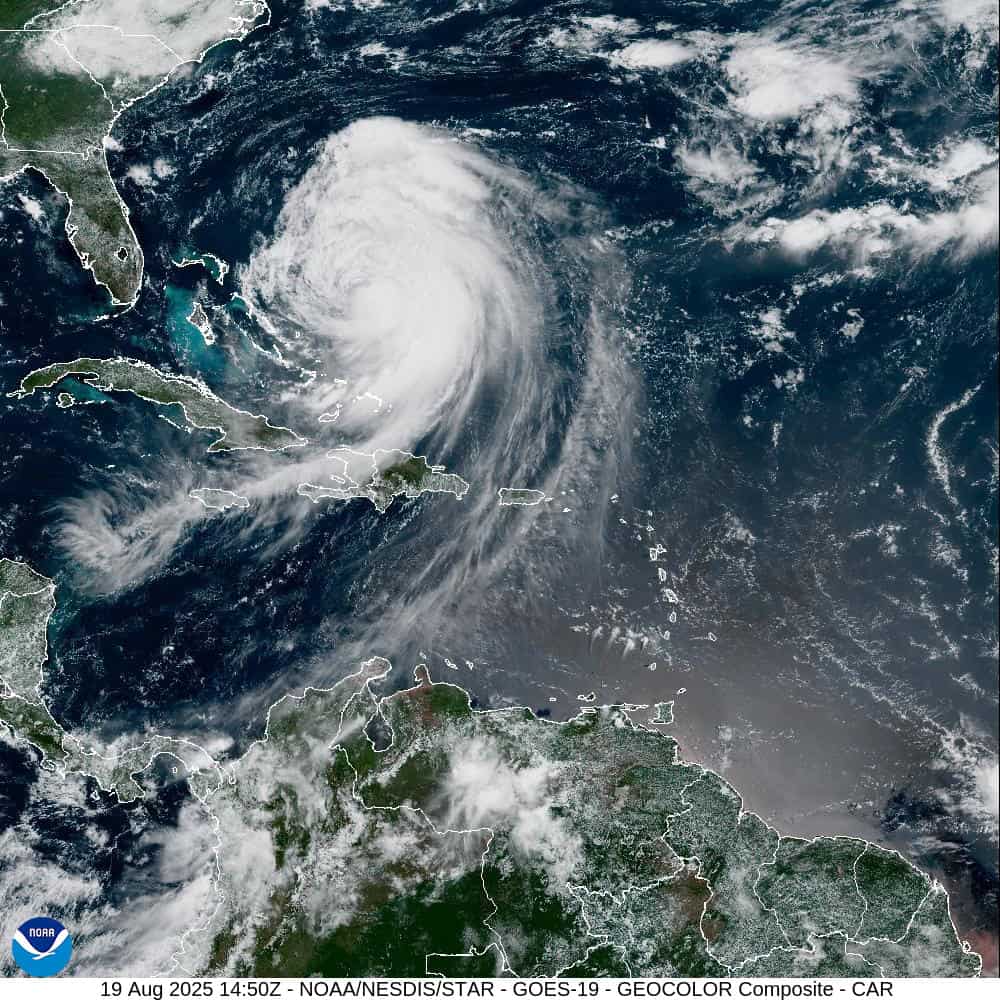
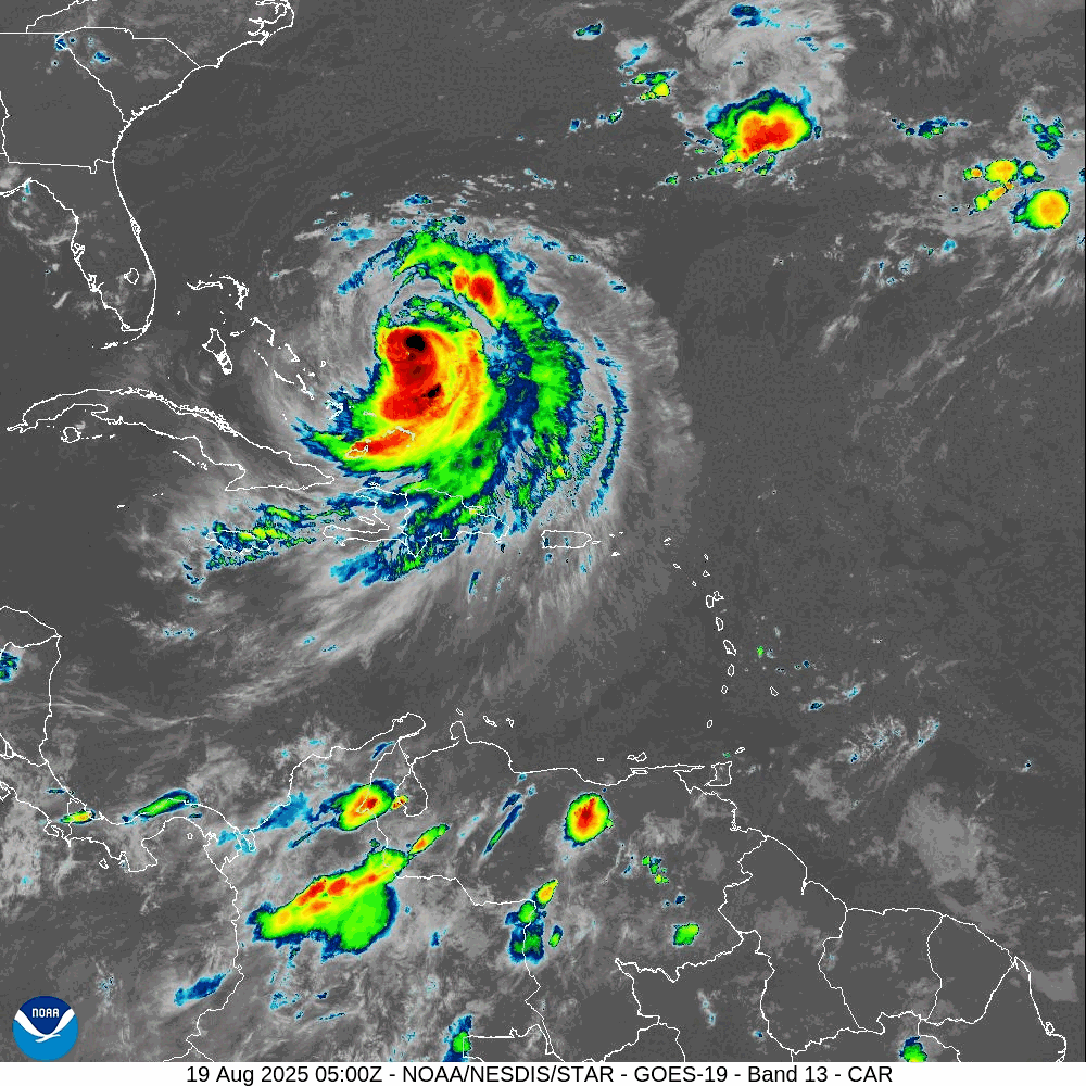
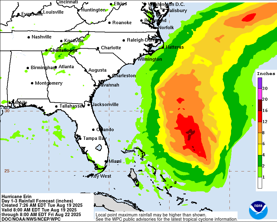
Tropical Cyclone Erin…is located about 495 miles south-southeast of Cape Hatteras, North Carolina
Atlantic Ocean
Tropical Cyclone Erin
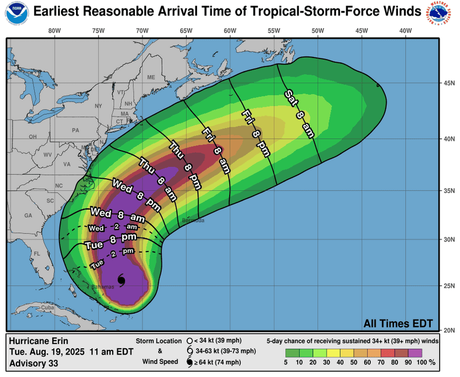
SWIMMING AT MOST U.S. EAST COAST BEACHES WILL REMAIN DANGEROUS OVER THE NEXT FEW DAYS DUE TO LIFE-THREATENING RIP CURRENTS
According to the NHC advisory number 35A
Erin is moving toward the north-northwest near 12 mph (19 km/h). This motion with an increase in forward speed is expected for the rest of tonight followed by a northward motion on Wednesday and then a northeastward motion on Thursday. On the forecast track, the center of Erin will pass to the east of the Bahamas tonight, and then move over the western Atlantic between the U.S. east coast and Bermuda on Wednesday and Thursday. Maximum sustained winds are near 100 mph (155 km/h) with higher gusts. Satellite imagery and reports from an Air Force Reserve Hurricane Hunter aircraft indicate that Erin is getting better organized, and slow strengthening is expected through Thursday night. Erin is a large hurricane. Hurricane-force winds extend outward up to 80 miles (130 km) from the center and tropical-storm-force winds extend outward up to 230 miles (370 km).
HAZARDS AFFECTING LAND
RAINFALL: Rainfall will be diminishing across the Turk and Caicos and the Bahamas late this afternoon and evening. Heavy rainfall is possible on the Outer Banks of North Carolina Wednesday night into Thursday with the potential for 1 to 2 inches.
WIND: Tropical storm conditions are expected over portions of the North Carolina Outer Banks beginning late Wednesday or Wednesday night. Tropical storm conditions are possible in the watch area north of Duck, North Carolina to Cape Charles Light beginning Thursday. Tropical storm conditions are possible in Bermuda beginning Thursday.
SURF: Swells generated by Erin will affect the Bahamas, Bermuda, the east coast of the United States, and Atlantic Canada during the next several days. These rough ocean conditions are expected to cause life-threatening surf and rip currents.
STORM SURGE: The combination of a dangerous storm surge and the tide will cause normally dry areas near the coast to be flooded by rising waters moving inland from the shoreline. The water could reach the following heights above ground somewhere in the indicated areas if the peak surge occurs at the time of high tide…
Cape Lookout to Duck, North Carolina…2 to 4 ft
The deepest water will occur along the immediate coast where the surge will be accompanied by large and dangerous waves. Surge-related flooding depends on the relative timing of the surge and the tidal cycle, and can vary greatly over short distances.
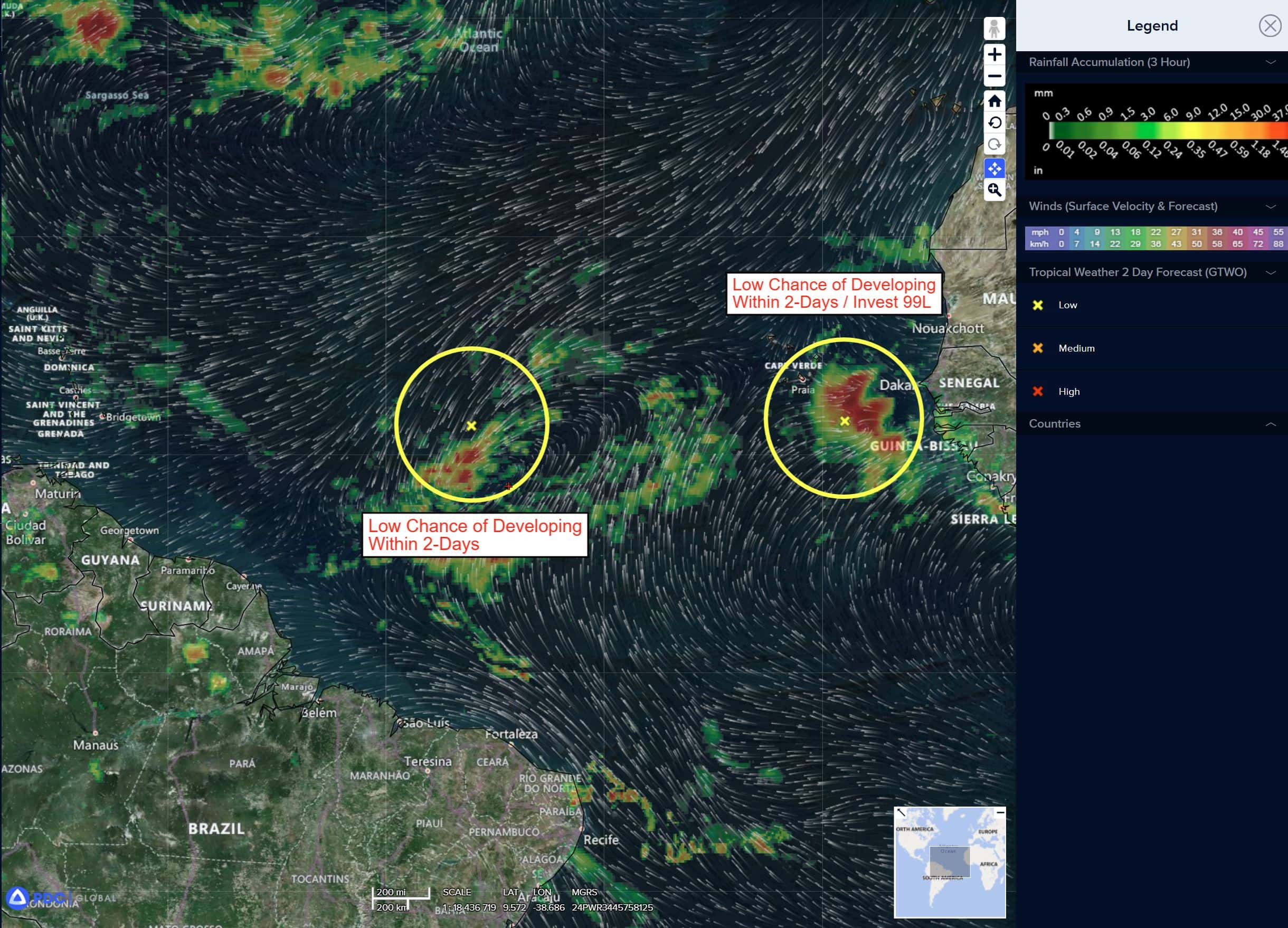
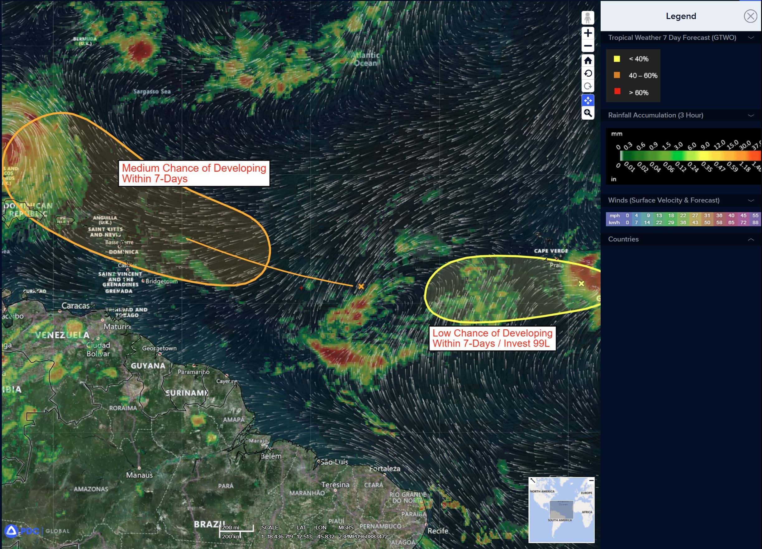
Near the Leeward Islands in the Tropical Atlantic
>>> A tropical wave located over the central tropical Atlantic continues to produce a broad area of disorganized showers and thunderstorms. Environmental conditions appear conducive for gradual development of this system, and a tropical depression could form toward the end of the week or this weekend. This system should move westward to west-northwestward at about 20 mph and approach the vicinity of the northern Leeward Islands on Friday.
* Formation chance through 48 hours…low…10 percent
* Formation chance through 7 days…medium 60 percent
Eastern Tropical Atlantic
Invest 99L
>>> A tropical wave located about a hundred miles to the south of the Cabo Verde Islands continues to produce disorganized showers and thunderstorms. Environmental conditions appear marginally favorable for additional development over the next couple of days as the system moves westward at around 15 mph. Towards the end of this week, this system could encounter a less favorable environment, limiting its development chances after that time.
* Formation chance through 48 hours…low…30 percent
* Formation chance through 7 days…low…30 percent
Caribbean Sea: There are no active tropical cyclones
Tropical cyclone formation is not expected during the next 7-days.
Gulf of America: There are no active tropical cyclones