
")
Current Snapshot
For all the latest updates visit: DisasterAWARE
erin
GOES19-CAR-13-1000×1000
181447_earliest_reasonable_toa_34
181447INTQPF_sm

05L_tracks_latest
2
7
1800×1080
By PDC’s Senior Weather
Specialist Glenn James

The Pacific Disaster Center’s (PDC Global) Monday, August 18, 2025, Tropical Cyclone Activity Report…for the Atlantic Ocean, the Caribbean Sea, and the Gulf of America
Current Tropical Cyclones:
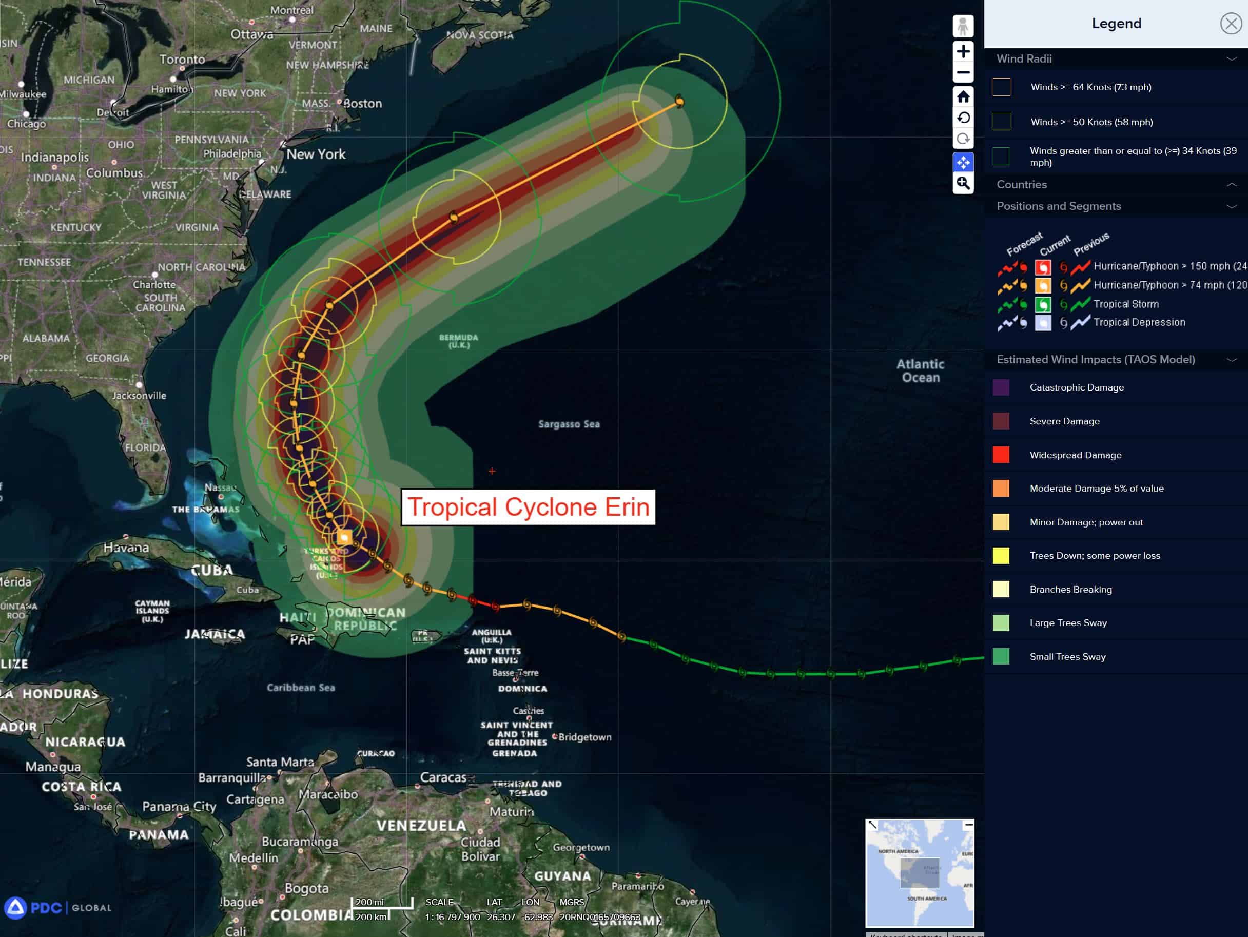
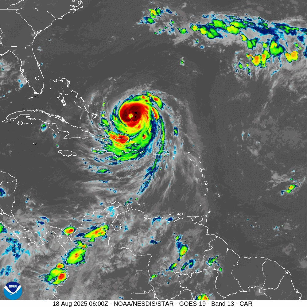
Tropical Cyclone Erin…is located about 780 miles south-southeast of Cape Hatteras, North Carolina
Atlantic Ocean
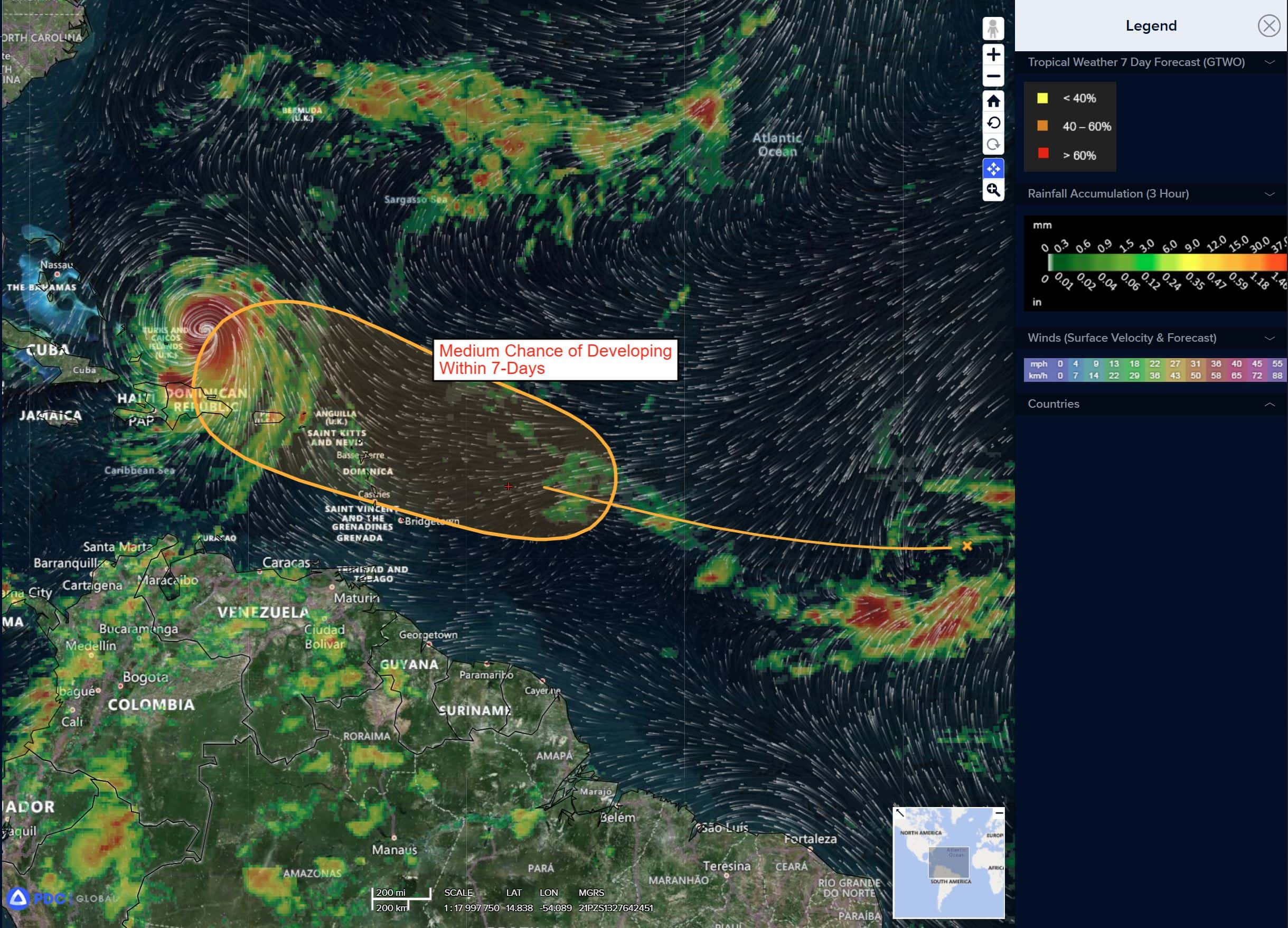
Tropical Cyclone Erin
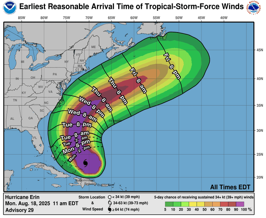
ERIN SLOWING DOWN WHILE MOVING NORTHWESTWARD …DANGEROUS RIP CURRENTS EXPECTED ALONG U.S. EAST COAST BEACHES DURING THE NEXT SEVERAL DAYS
According to the NHC advisory number 31A
Erin is moving toward the northwest near 7 mph (11 km/h). A turn to the north is forecast later today or tonight. On the forecast track, the core of Erin is expected to move away from the southeastern Bahamas and the Turks and Caicos Islands this morning and move east of the remainder of the Bahamas later today. The hurricane is then expected to move between Bermuda and the east coast of the United States by the middle of the week. Reports from an Air Force Reserve Hurricane Hunter aircraft indicate that maximum sustained winds have decreased to an estimated 120 mph (195 km/h) with higher gusts. Erin is a category 3 hurricane on the Saffir-Simpson Hurricane Wind Scale. Fluctuations in strength are expected during the next couple of days. However, Erin is likely to remain a dangerous major hurricane through the middle of this week. Hurricane-force winds extend outward up to 80 miles (130 km) from the center and tropical-storm-force winds extend outward up to 230 miles (370 km). A wind gust to 53 mph (85 km/h) was recently reported at Providenciales in the Turks and Caicos Islands.
HAZARDS AFFECTING LAND
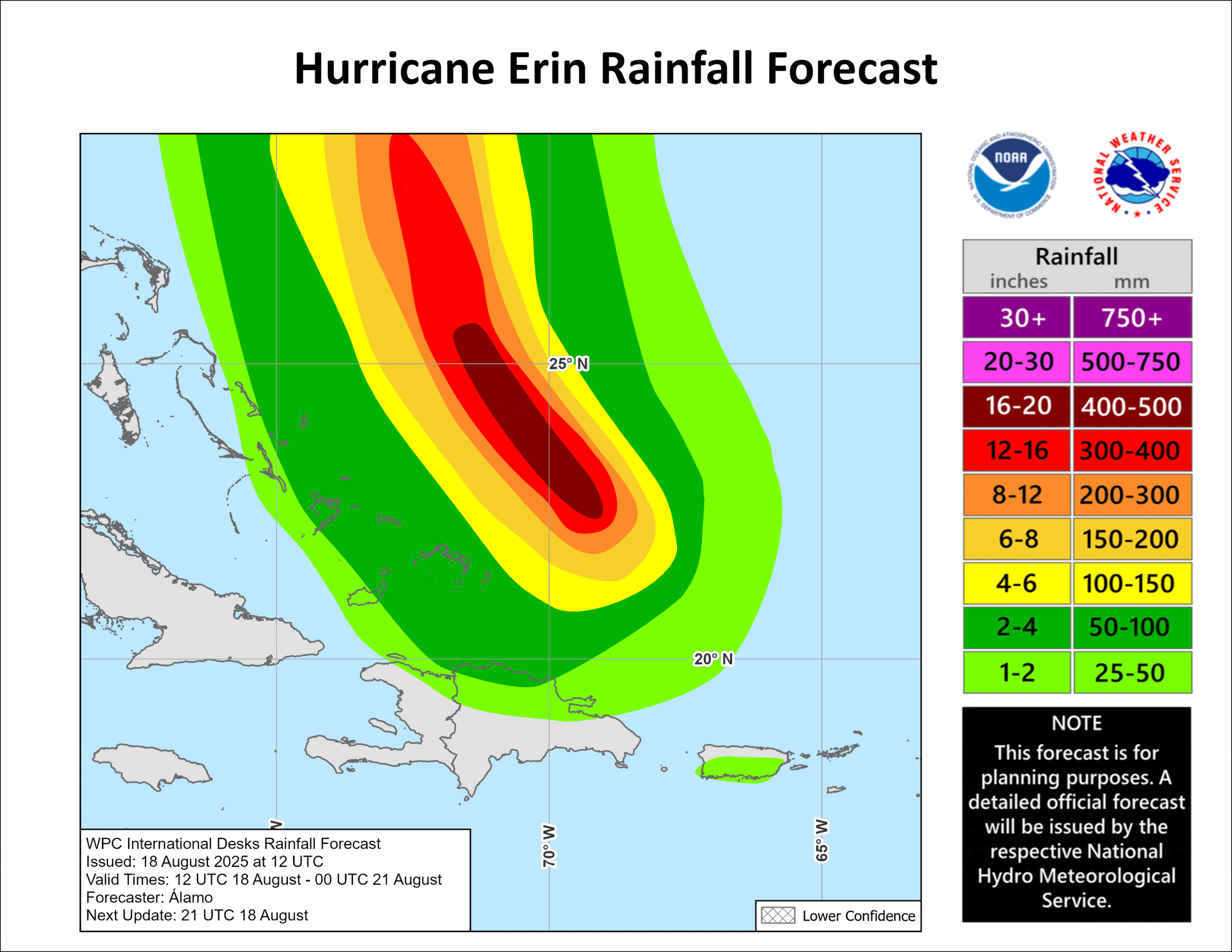
RAINFALL: Erin will produce localized areas of heavy rainfall across portions of the southeastern Bahamas into Wednesday. Additional rainfall of 2 to 4 inches, with storm total amounts to 8 inches, is possible, which could lead to flash flooding and urban flood concerns. Portions of Hispaniola, the central Bahamas, and the Turks and Caicos should receive an additional 1 to 2 inches of rain as well.
WIND: Tropical storm conditions are expected for a few more hours across the Turks and Caicos Islands and the southeast Bahamas. Tropical storm conditions are possible in portions of the central Bahamas today. Tropical storm conditions are possible over portions of the North Carolina Outer Banks beginning late Wednesday.
SURF: Swells generated by Erin will affect the Bahamas, Bermuda, the east coast of the United States, and Atlantic Canada during the next several days. These rough ocean conditions are expected to cause life-threatening surf and rip currents.
STORM SURGE: Minor coastal flooding is possible in areas of onshore winds in the Turks and Caicos Islands and the southeast Bahamas. Near the coast, the surge will be accompanied by large waves.
The combination of a dangerous storm surge and the tide will cause normally dry areas near the coast to be flooded by rising waters moving inland from the shoreline. The water could reach the following heights above ground somewhere in the indicated areas if the peak surge occurs at the time of high tide…
Cape Lookout to Duck, North Carolina…2 to 4 ft
The deepest water will occur along the immediate coast where the surge will be accompanied by large and dangerous waves. Surge-related flooding depends on the relative timing of the surge and the tidal cycle, and can vary greatly over short distances.
Near the Leeward Islands in the Tropical Atlantic
>>> A tropical wave located over the central tropical Atlantic continues to produce a broad area of disorganized showers and thunderstorms. Environmental conditions appear conducive for gradual development of this system, and a tropical depression could form toward the end of the week or weekend. This system should move westward to west-northwestward at about 20 mph across the central tropical Atlantic and approach the vicinity of the Leeward Islands on Friday.
* Formation chance through 48 hours…low…10 percent
* Formation chance through 7 days…medium 60 percent
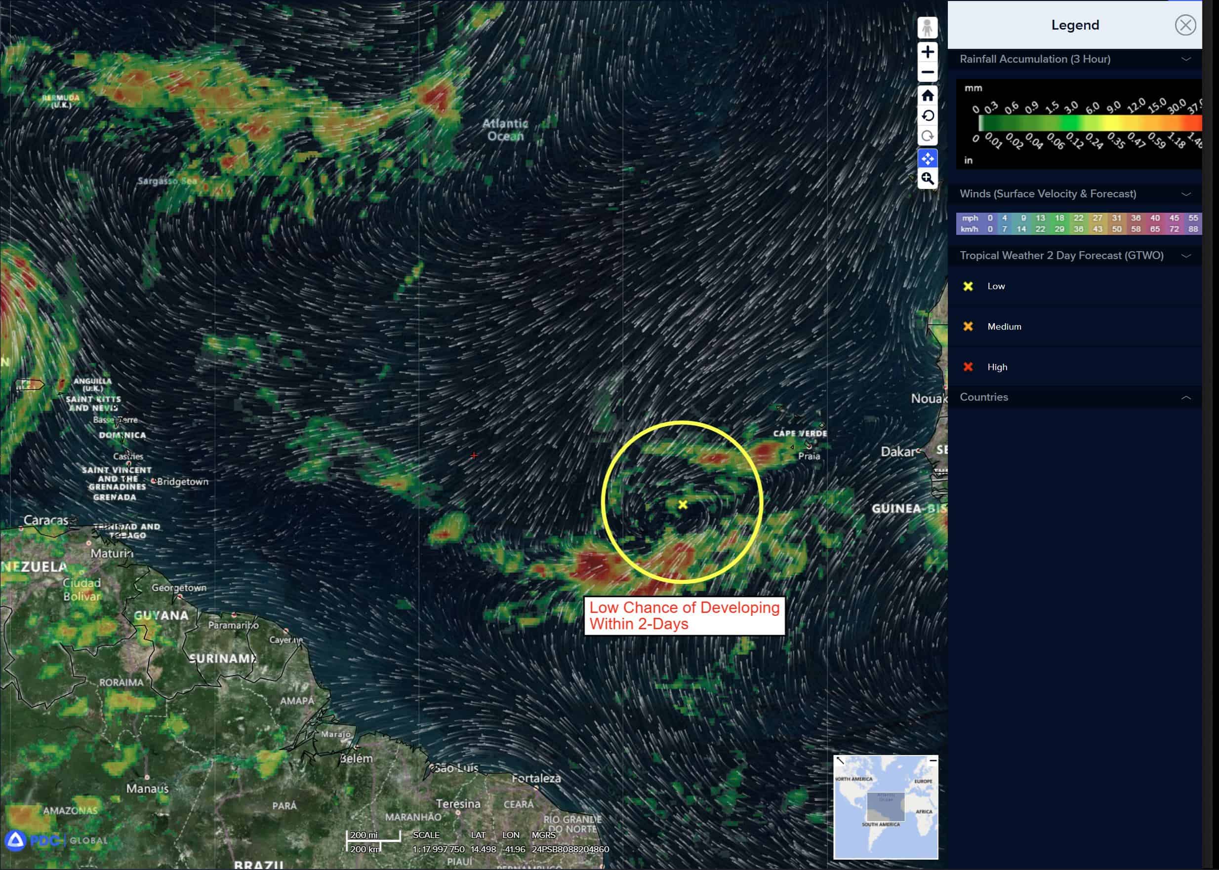
Eastern Tropical Atlantic
>>> A tropical wave located a few hundred miles to the southeast of the Cabo Verde Islands continues to produce a concentrated area of showers and thunderstorms. Environmental conditions appear generally favorable for additional development over the next couple of days as the system moves westward at around 15 mph. Towards the end of this week, this system could encounter a less favorable environment, limiting its development chances after that time.
* Formation chance through 48 hours…low…30 percent
* Formation chance through 7 days…low…30 percent
Caribbean Sea: There are no active tropical cyclones
Tropical cyclone formation is not expected during the next 7-days.
Gulf of America: There are no active tropical cyclones