
")
Current Snapshot
For all the latest updates visit: DisasterAWARE
east
1800x1080e
wpac
31W_041200sair
31W_tracks_latest
32W_041200sair
32W_tracks_latest
By PDC’s Senior Weather
Specialist Glenn James

The Pacific Disaster Center’s (PDC Global) Tuesday, November 4, 2025, Tropical Cyclone Activity Report…for the Pacific Ocean, the Indian Ocean, and adjacent Seas
Current Tropical Cyclones:
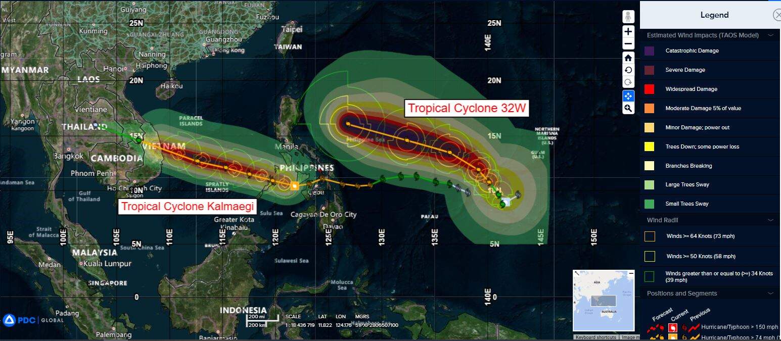
Tropical Cyclone 31W (Kalmaegi)…is located 240 NM south of Manila, Philippines
Tropical Cyclone 32W…is located 216 NM east of Yap
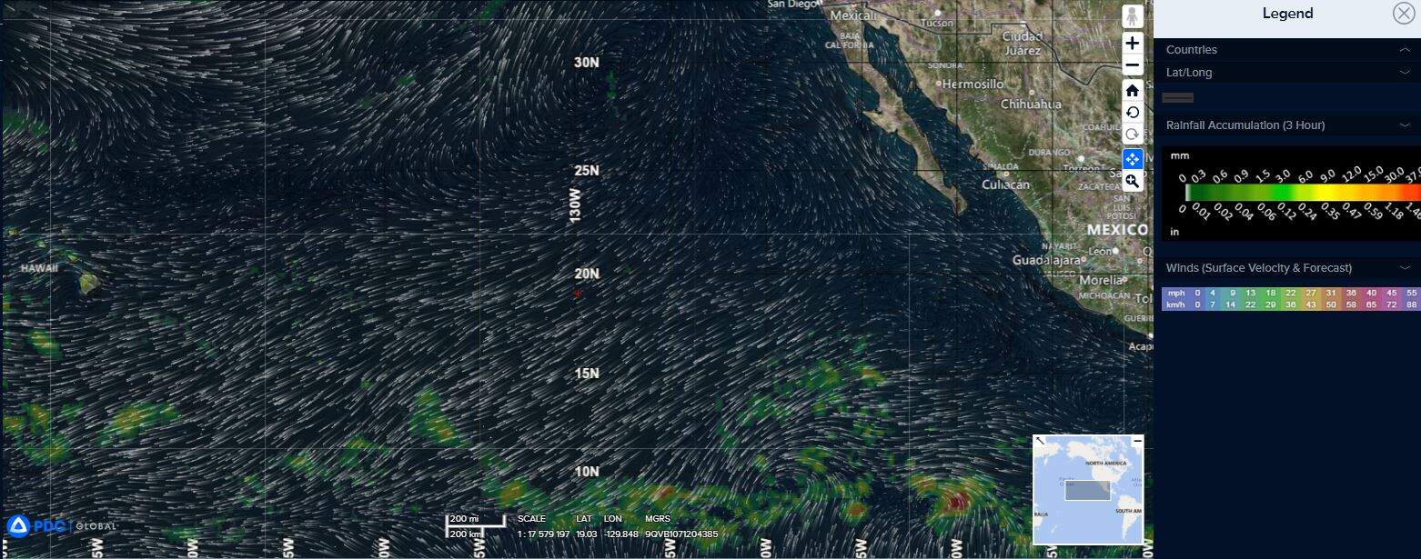
Northeast Pacific Ocean: There are no Tropical Cyclones
Tropical cyclone formation is not expected during the next 7 days.
Central Pacific Ocean: There are no Tropical Cyclones
Tropical cyclone formation is not expected during the next 7 days.
Western Pacific, Indian Ocean, and adjacent Seas:
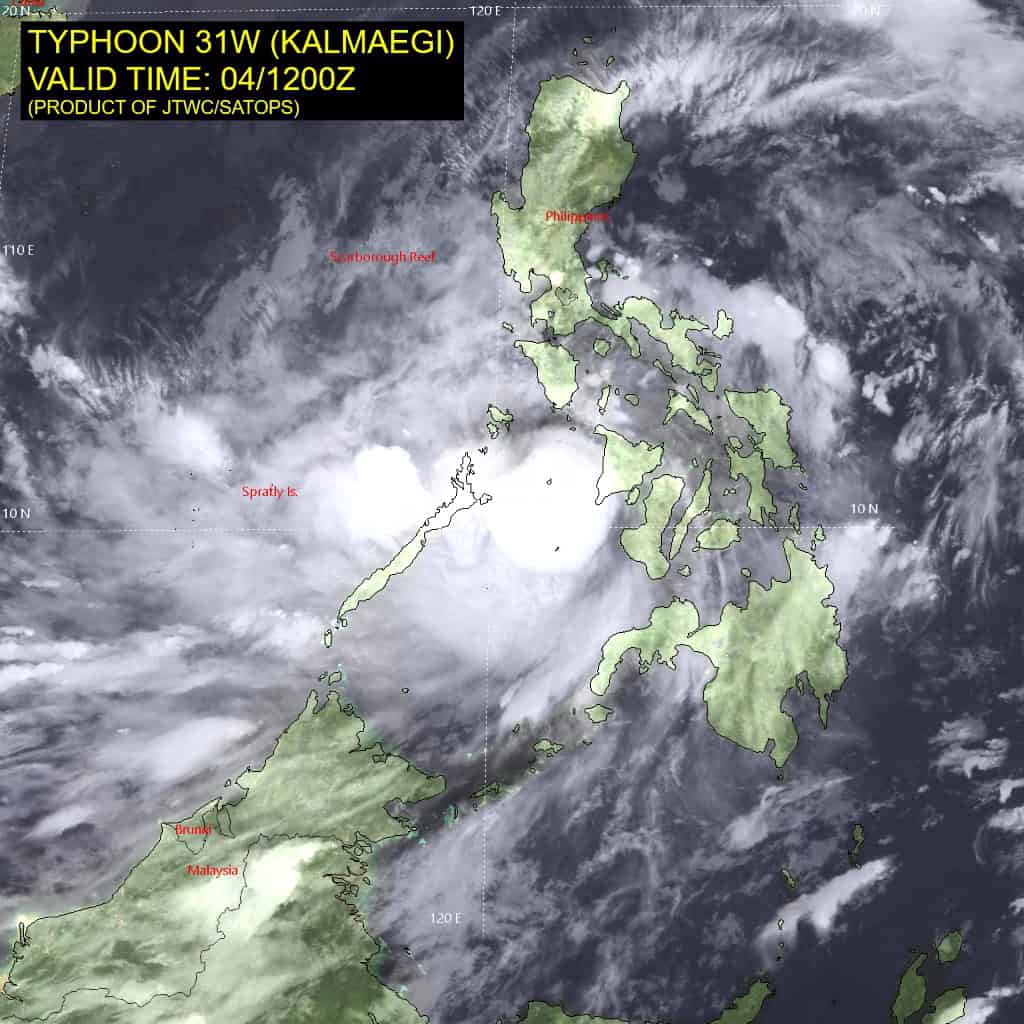
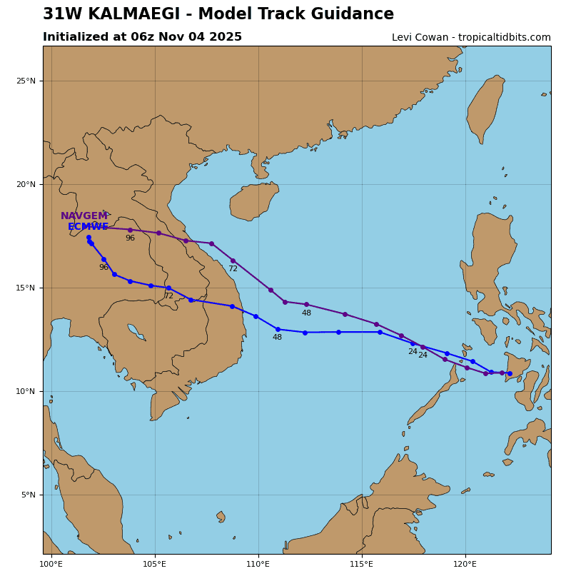
Tropical Cyclone 31W (Kalmaegi)
According to the JTWC warning number 14…sustained winds are 70 knots with gusts to 85 knots
Typhoon 31W (Kalmaegi) is still recovering from its time over the central Philippines having temporarily decreased in intensity over the past 6 hours. The structure of TY Kalmaegi shows signs of tightening again as the circulation enters the Sulu Sea. Major convective activity is currently flaring in the southwest quadrant as depicted by animated enhanced infrared (eir) satellite imagery.
encountering the northern portion of Palawan, Philippines. Following landfall over Palawan around 12 hours, the system will start a northwestward track as ridging over the Gulf of Tonkin takes over steering.
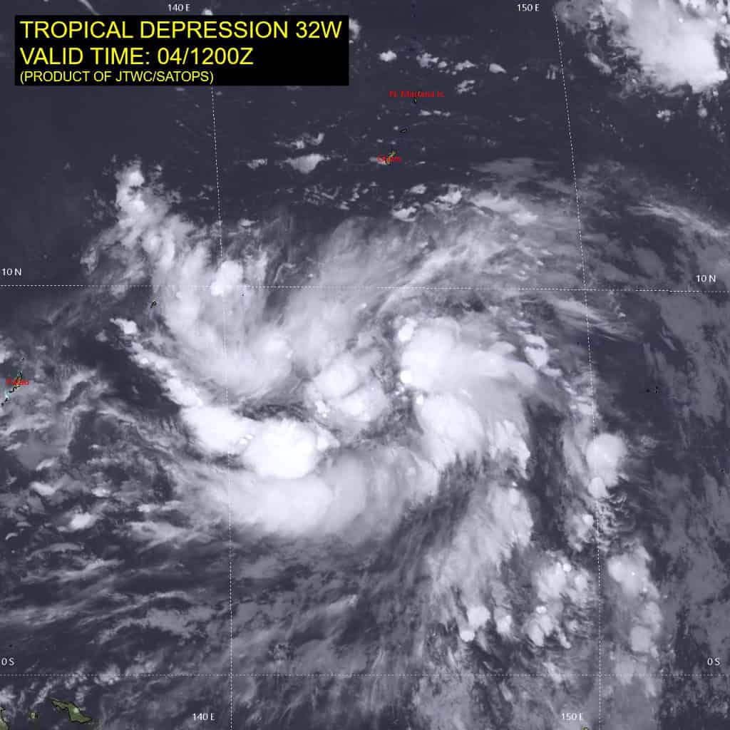
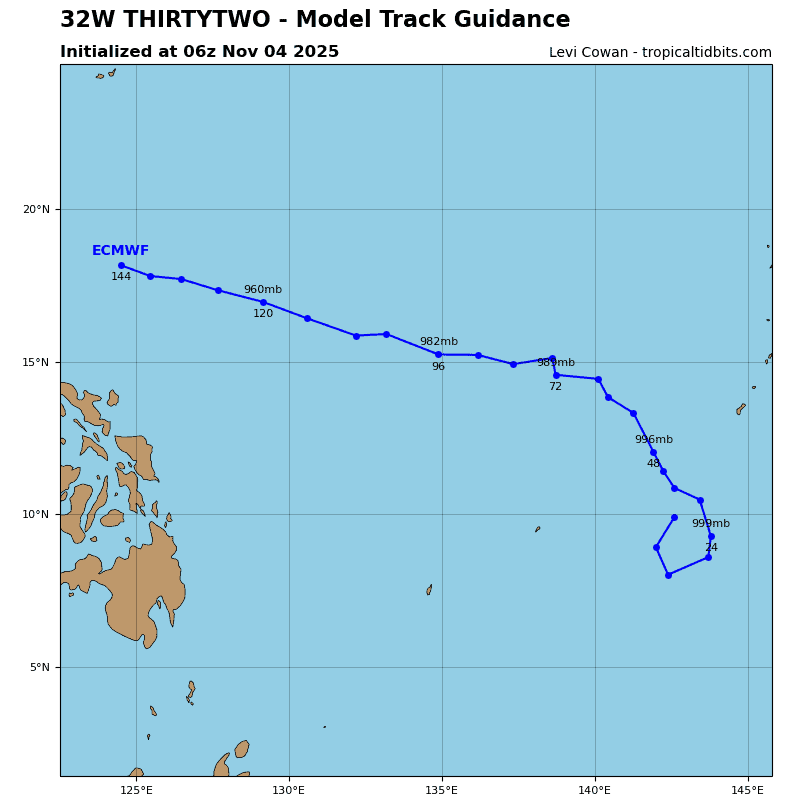
Tropical Cyclone 32W
According to the JTWC warning number 2…sustained winds are 30 knots with gusts to 40 knots
Animated enhanced infrared (eir) satellite imagery depicts developing deep convective banding nearly fully obscuring the low-level circulation center (llcc) associated with tropical depression 32W.
Environmental conditions remain conducive to development, including warm (30-31 c) sea surface temperatures (sst), low vertical wind shear (vws) of 5-10 kts, good equatorward outflow channel, counteracted only by moderately dry air to the north and northwest.
TD 32W is expected to continue consolidating and intensifying over the forecast period as it tracks toward the northern Philippines. The system is initially forecast to remain in a weak steering environment dominated by a northeasterly low-level flow north of the llcc and a westward extension of a str centered to the northeast.
therefore, over the next 12 hours, TD 32W is forecast to track very slowly, or even remain quasi-stationary, while further consolidating into a more compact tropical storm. simultaneously, the
extension of the str is expected to retrograde eastward, allowing the well-structured system to turn northwestward around 24-36 hours. Afterward, the system will track along the southwestern periphery of the ridge.
In terms of intensity, TD 32W is expected to reach typhoon-level wind maxima within the next 36 hours and continue strengthening as it remains in a favorable environment, provided the vortex becomes fully shielded from entraining dry air.