
")
Current Snapshot
For all the latest updates visit: DisasterAWARE
31p
31P_210600sair
himawari9_ir_31P_202504211400_lat-11.6-lon136.6

31P_tracks_latest
By PDC’s Senior Weather
Specialist Glenn James

The Pacific Disaster Center’s (PDC Global) Monday, April 21, 2025, Tropical Cyclone Activity Report…for the Pacific Ocean, the Indian Ocean, and adjacent Seas
Current Tropical Cyclones:
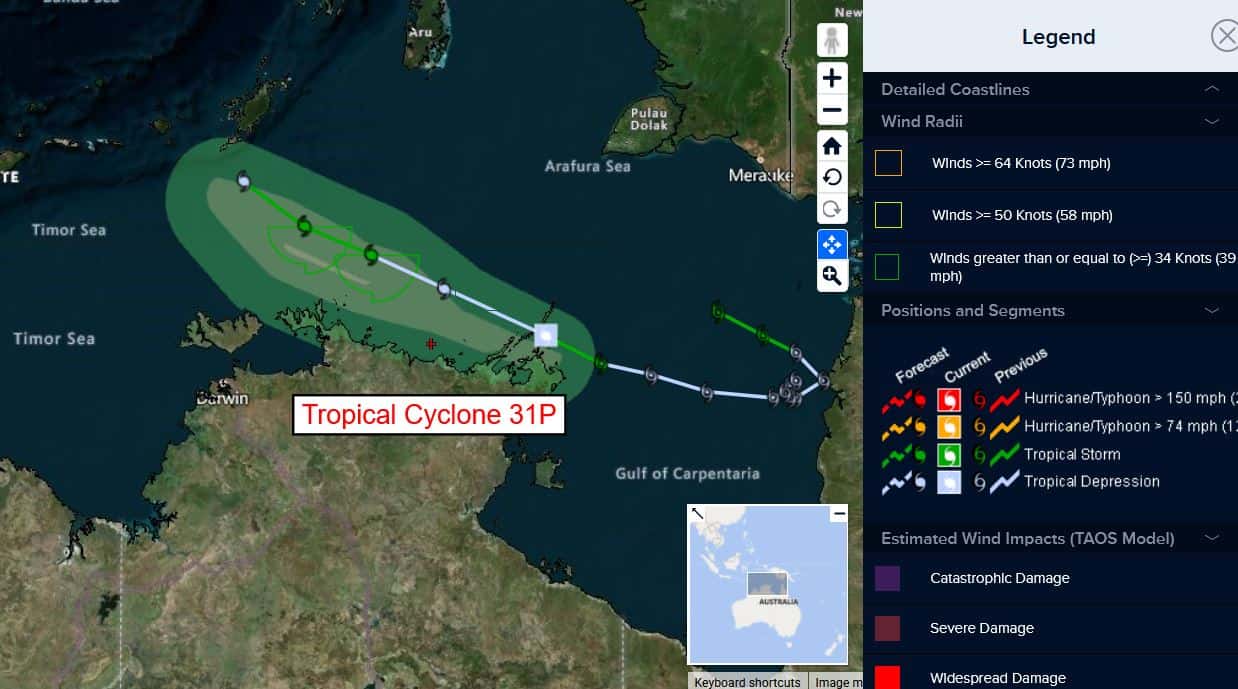
Tropical Cyclone 31P…is located approximately 226 NM east-northeast of Darwin, Australia
Northeast Pacific Ocean: There are no Tropical Cyclones
The last regularly scheduled Tropical Cyclone Activity Report of the 2024 eastern North Pacific Hurricane Season has been issued. Routine issuance of this section of the PDC product will resume on May 15, 2025. During the off-season, Special Tropical Weather Outlooks will be issued as conditions warrant by the NHC.
Central Pacific Ocean: There are no Tropical Cyclones
The 2024 central North Pacific hurricane season has ended. As such, the final routine Tropical Cyclone Activity Report for the 2024 season has been issued. Routine issuance of this section of the PDC product will resume on June 1, 2025. During the off-season, Special Tropical Weather Outlooks will be issued as conditions warrant by the CPHC.
Western Pacific, Indian Ocean, and adjacent Seas:
Southwest Pacific Ocean
Tropical Cyclone 31P
According to the JTWC Warning number 16, sustained winds are 30 knots, with gusts to 40 knots.
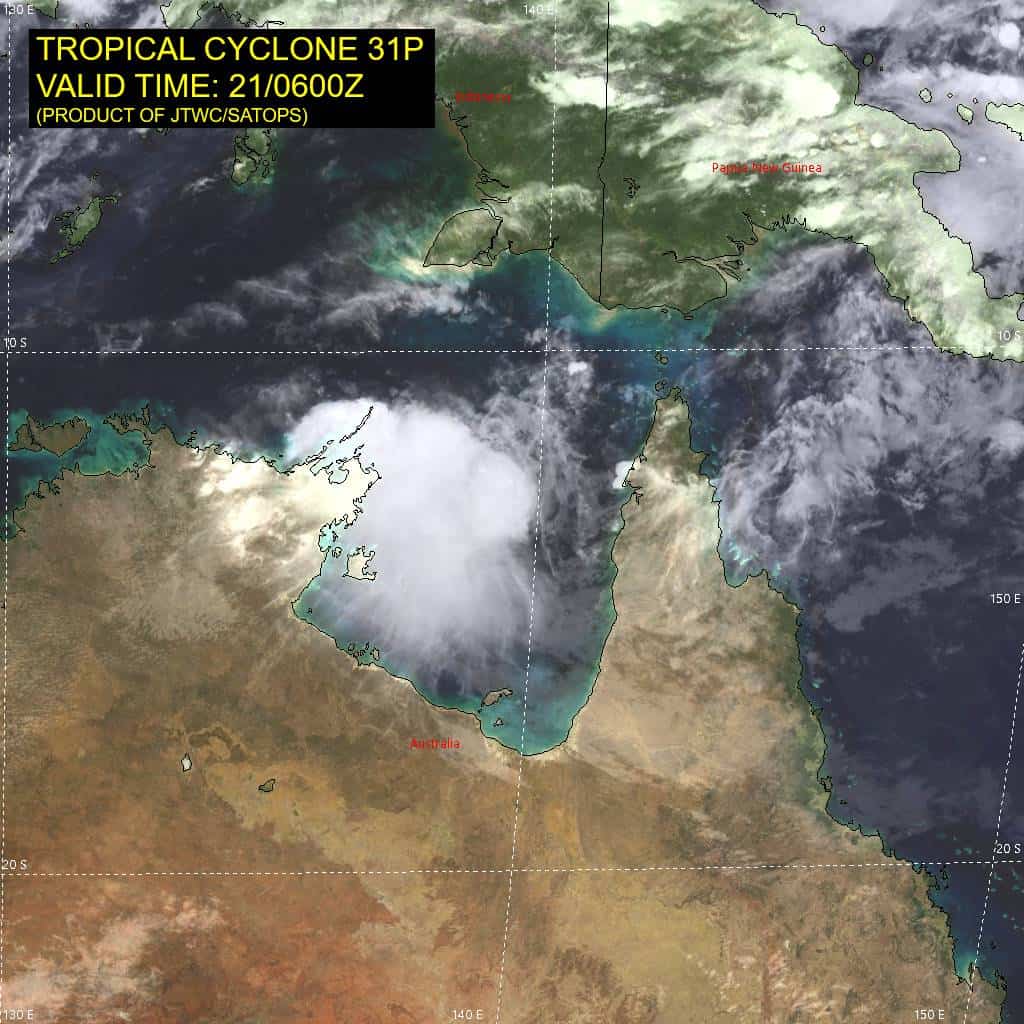
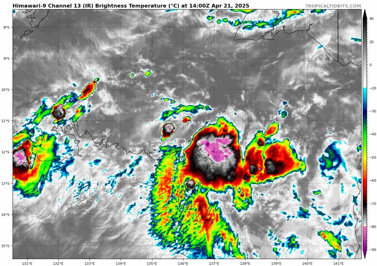
Animated enhanced infrared satellite imagery depicts a very weak, and fully exposed low level circulation center passing over the southern portion of the Wessel Islands. The vigorous convection noted six hours ago rapidly and completely collapsed, revealing a small low level circulation center (llcc). The most recent satellite data shows convection flaring up once more along the eastern flank of the circulation but it remains disorganized and is likely to be unable to persist or reorganize in the short term. A color-enhanced 91ghz microwave image revealed a weak llcc just north of Gove airport, with only fragmentary, weak low level banding features. the vortex is so shallow that it is barely evident on the Gove radar.
The environment is generally favorable, with low vertical wind shear, warm sea surface temperatures and decent outflow aloft, but the continued intrusion of dry air in the low levels and interaction with terrain are disrupting the system.
TC 31P is moving northwestward at a steady speed of around 10 knots, along the northern side of a low- to mid-level ridge situated over northern Australia. No significant change is expected in the overall steering pattern through the forecast period, other than a general weakening of the steering gradient after 24 hours which will cause TC 31P to slow down slightly towards the end of the forecast.
The system is currently passing over Guluwuru and Raragala Islands and will soon emerge into the Arafura sea. The northwestward track means the system will move further away from land as times goes on.
Shear is forecast to steadily decrease over the next 24 to 36 hours, and as the system moves further away from land and frictional effects lessen, models indicate a short period of vortex alignment and intensification.
However, as the system moves further equatorward, it moves into a more hostile shear regime and will rapidly weaken below warning threshold by 48 hours. However, there is a possibility of regeneration if the system loops back to the south as several of the models suggest.