
")
Current Snapshot
For all the latest updates visit: DisasterAWARE

1800x1080e
eeeeee
fengshen
30W_181200sair
30W_tracks_latest
04s
04S_181200sair
04S_tracks_latest
By PDC’s Senior Weather
Specialist Glenn James

The Pacific Disaster Center’s (PDC Global) Saturday, October 18, 2025, Tropical Cyclone Activity Report…for the Pacific Ocean, the Indian Ocean, and adjacent Seas
Current Tropical Cyclones:
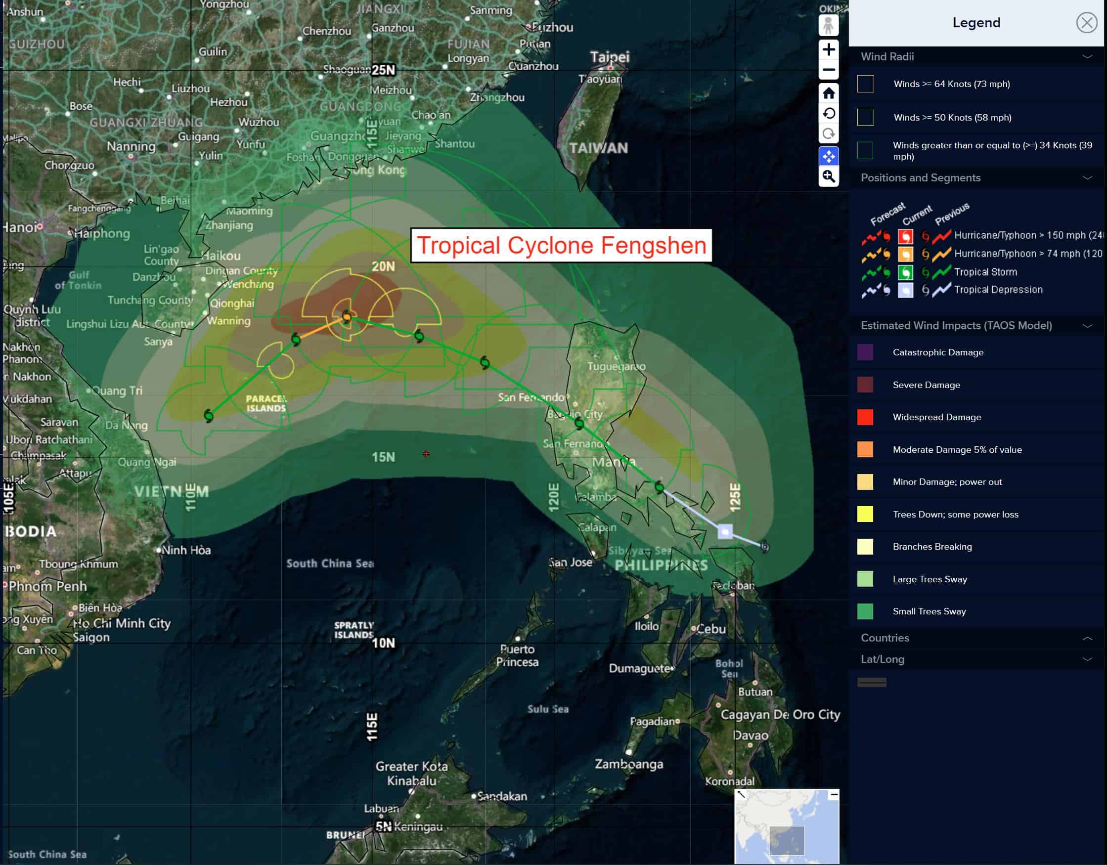
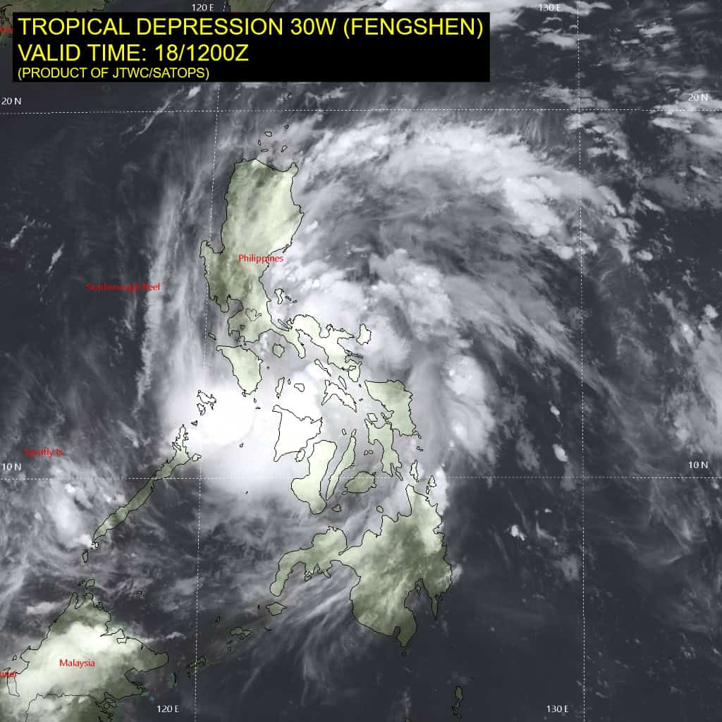
Tropical Cyclone 03W (Fengshen)…is located approximately 190 NM east-southeast of Manila, Philippines
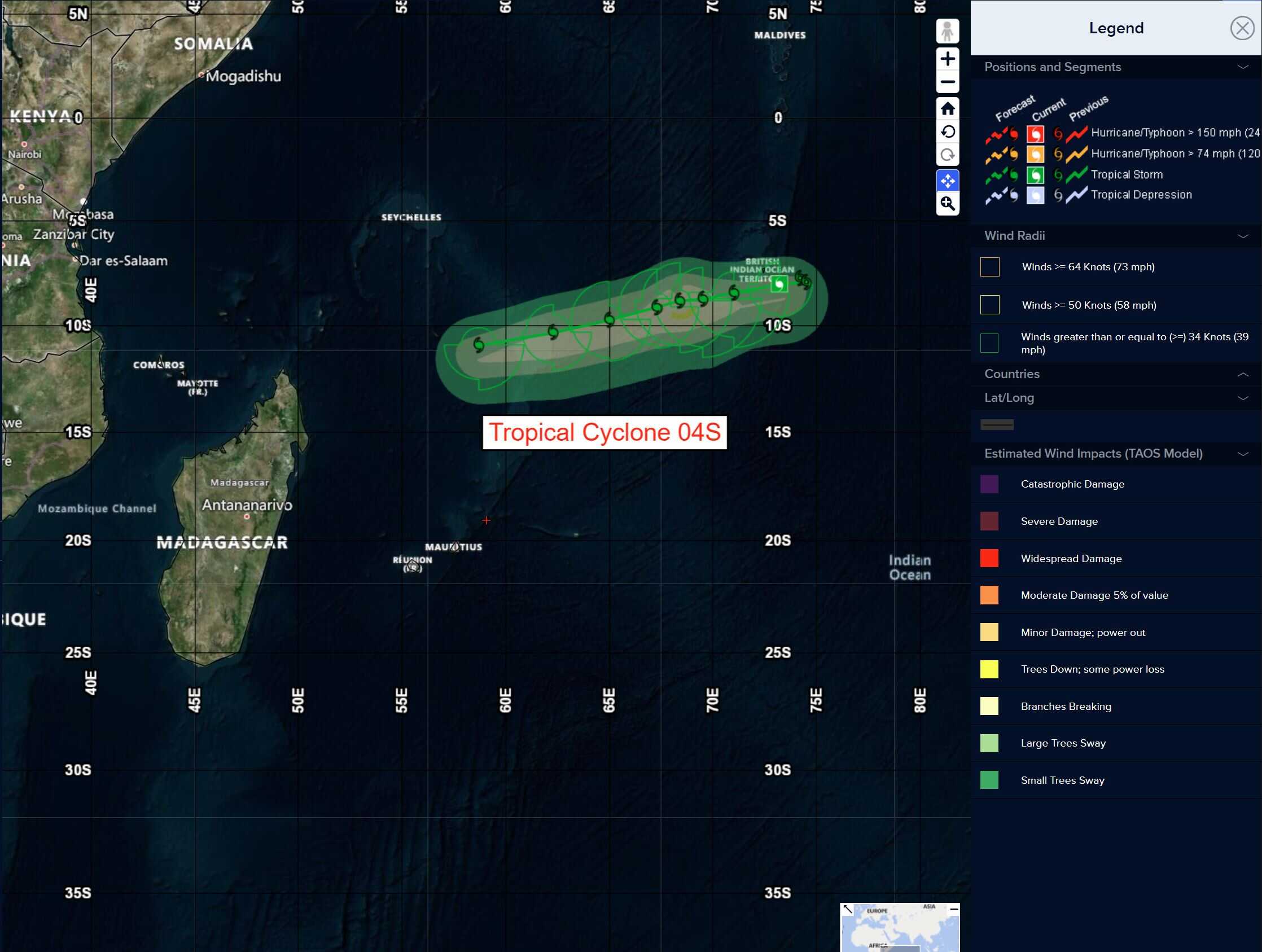
Tropical Cyclone 04S…is located approximately 68 NM southeast of Diego Garcia
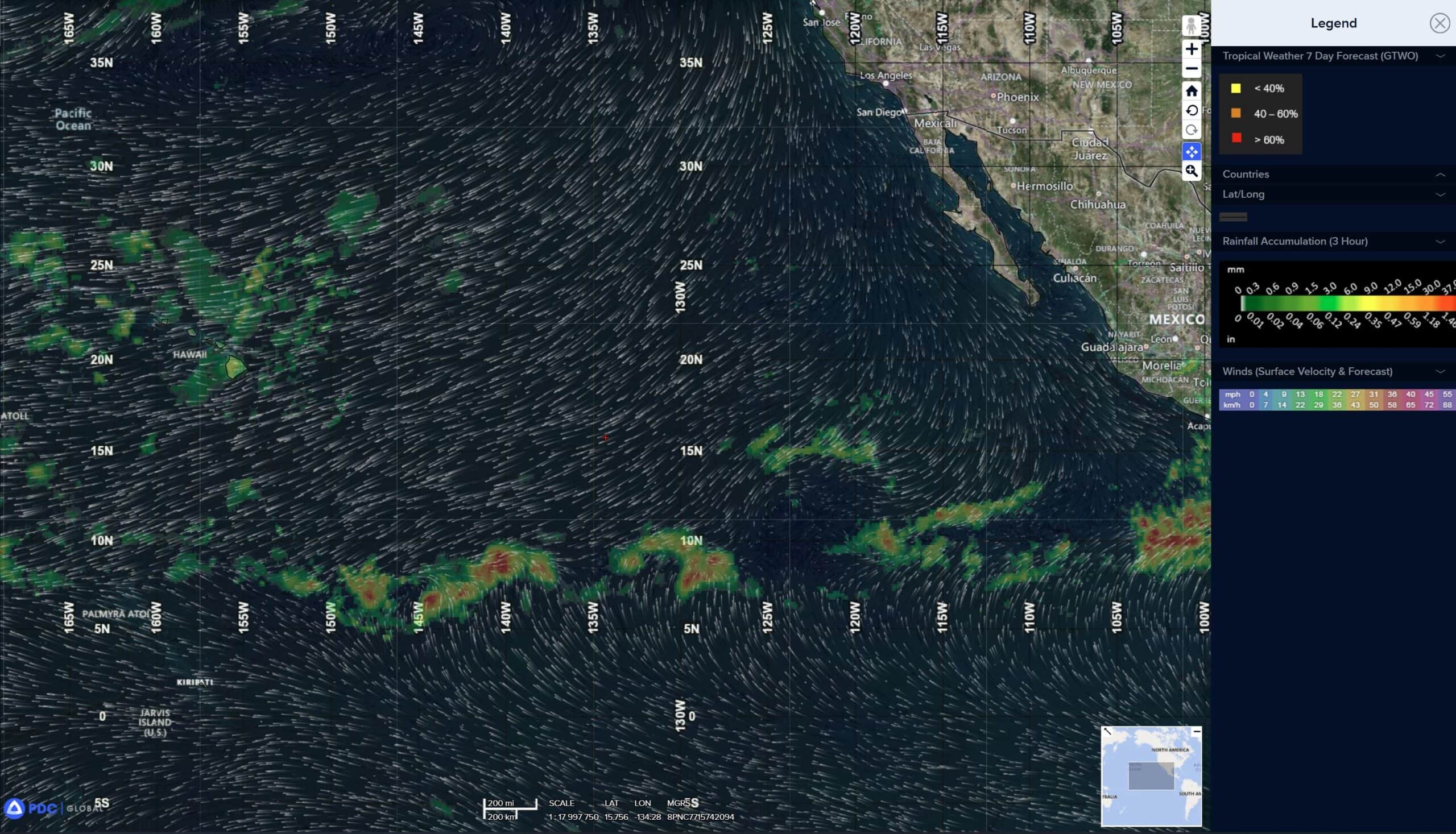
Northeast Pacific Ocean: There are no Tropical Cyclones
Tropical cyclone formation is not expected during the next 7 days.
Central Pacific Ocean: There are no Tropical Cyclones
Tropical cyclone formation is not expected during the next 7 days.
Western Pacific, Indian Ocean, and adjacent Seas:
Western Pacific
Tropical Cyclone 03W (Fengshen)
According to the JTWC warning number 3, sustained winds are 35 knots with gusts to near 45 knots
Animated enhanced infrared (eir) satellite imagery depicts a small core of deep convection embedded within a much larger rotation with fragmented convective bands concentrated over the western hemisphere (over the Philippines).
Animated radar data from Pagasa suggests a nascent low level circulation center (llcc) passing off the northwest coast of Catanduanes at 1200z, while a 181254z ascat-b pass showed a likely llcc over the far southeastern tip of Luzon, or just of offshore to the east.
Surface observations from virac were missing for several hours, but a 181300z observation showed winds had shifted from 070deg to 140deg over the previous three hours, highly suggestive of the llcc lying somewhere to the west of the station. The latest frames of eir and radar suggest the llcc is now positioned north of Naga City, moving rapidly to the northwest.
Environmental conditions are favorable and would be highly favorable if not for the proximity to land, which is disrupting development for the moment. Once the system moves away from Luzon and approaches the waters around the Palillo Islands, very warm waters with high ohc await, while shear remains low and radial outflow is strong.
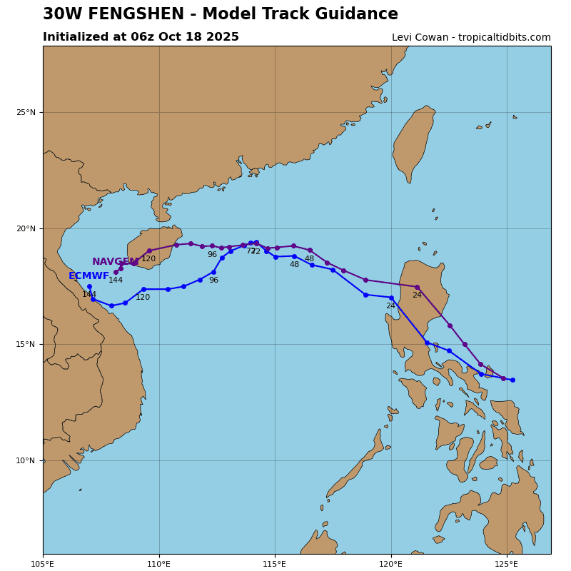
Tropical storm 30W is moving quickly off to the northwest, parallel to the northern coast of southeastern Luzon, along the southwestern side of a strong str centered far to the northeast. Over the course of the next 12 to 18 hours, TS 30W will pass close to the Palillo Islands and make landfall along the eastern coast of Luzon.
After making landfall, the system will quickly cross the island, pass through the Lingayen Gulf and emerge into the South China Sea. Once back over water, the system will continue to track northwestward at a good clip until 48 hours, when it will slam head first into strong northeasterly flow associated with a cold surge funneling southward out of the Taiwan Strait.
In the near-term, as the system moves away from land and into more open waters, it is expected to rapidly intensify, but the peak intensity the system can reach will be limited by the short amount of time before making landfall. The peak intensity captured in the forecast points is 45 knots, but it is likely the system will reach a slightly higher peak just prior to making landfall.
As the system moves across the rugged terrain of Luzon it will weaken significantly, but quickly reform on the west side of Luzon. Once reestablished west of the Philippines, TS 30W will once again quickly intensify under favorable conditions, reaching a peak of 70 knots by 72 hours.
After 48 hours, the system will begin to slow down and could even become quasi-stationary for a time as it moves into a weak steering pattern, caught between deep-layer ridging to the east and west, while in the lower-levels it will be pushing up against the strong northeasterly flow trapped along the Chinese coast.
The influx of relatively dry and stable air into the western flank of the system, along with increased shear will begin to weaken the system immediately after 72 hours. As the system steadily weakens, it will come under the steering influence of the lower-level flow, and push southwestward from 72 through120 hours.
South Indian Ocean
Tropical Cyclone 04S
According to the JTWC warning number 3, sustained winds are 35 knots with gusts to near 45 knots
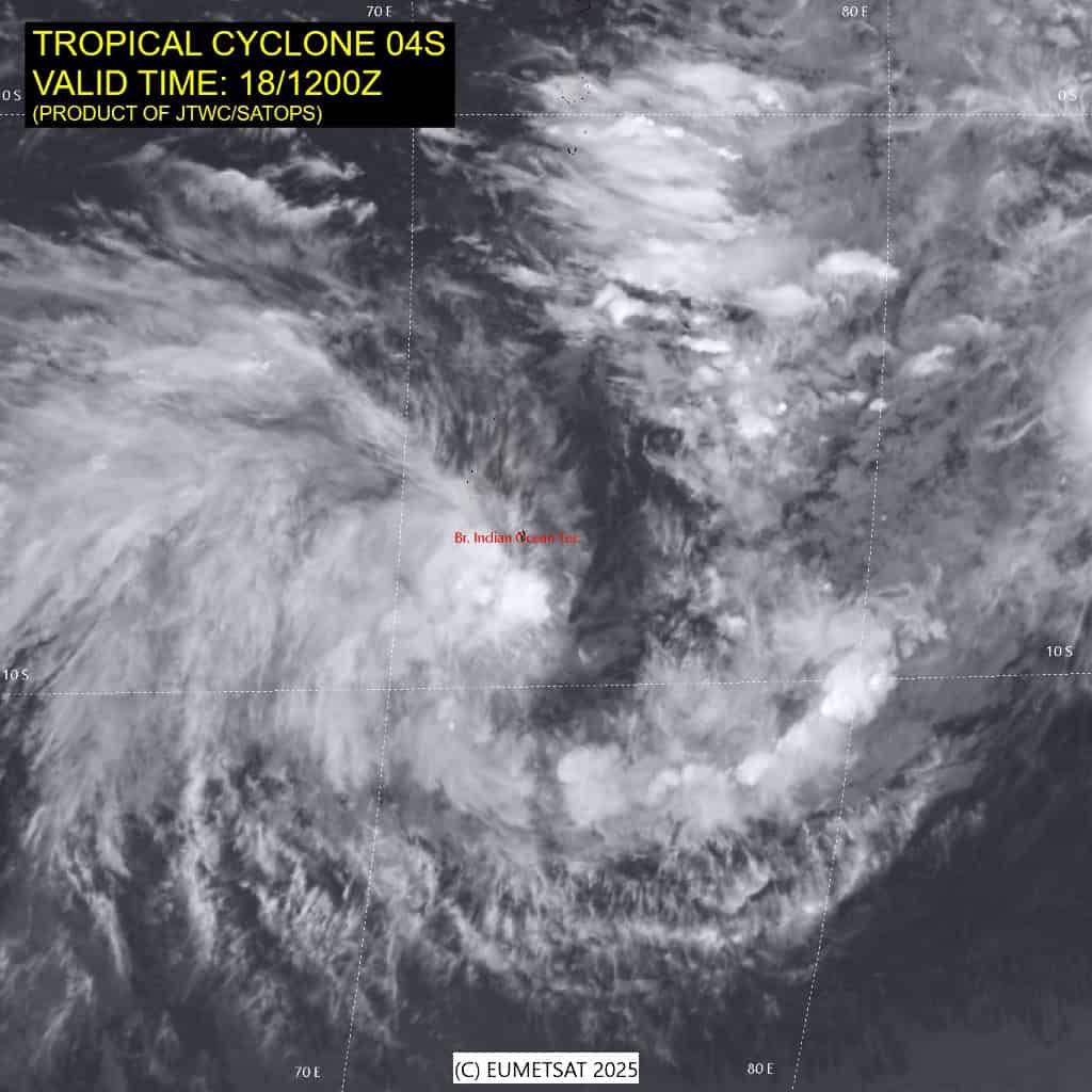
Animated multi-spectral satellite imagery (msi) indicates that TC
04S remains mostly exposed, with the actual center hiding out under some thin cirrus blowoff from redeveloping convection to the northwest. The low level circulation center (llcc) remains rather elongated and disorganized in the msi, with several small spinners observed shooting out to the east, then wrapping back in towards the center.
Surface observations from Diego Garcia were missing for several hours but the 181255z observation shows winds from the 260 degrees at 21 knots gusting to 33 knots and pressure down to 1000 mb, which suggests the llcc is to the south-southeast of the station and approaching cpa.
Environmental conditions are marginally favorable, though shear remains a bit too high significant near-term development, coming in at 20-25 knots from the east
TC 04S is now approaching its closest point of approach to Diego Garcia and is forecast to pass about 50 NM to the
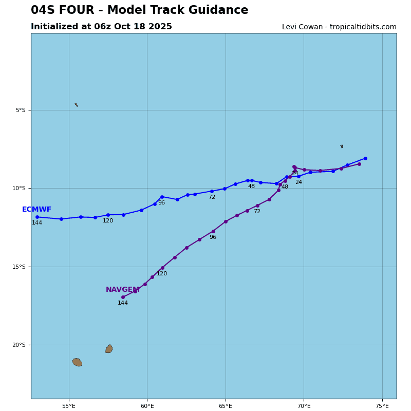
south within the next few hours. There are no significant changes in the forecast philosophy, and TC 04S is forecast to continue tracking southwestward along the northern side of the str through entire forecast period.
The passage of a mid-latitude trof far to the south, is expected to result in a weakening of the ridge pattern around 24 hours, which will result in a notable slowing of forward speed starting at 24 hours and continuing through 48 hours. The trof will pass by quickly, and by 48 hours, TC 04S will begin to accelerate to the southwest as the ridge strengthens and moves westward.
In terms of intensity, the system continues to struggle against moderate easterly shear, and the presence of dry mid-level air, which the hafs-a has finally picked up on. The forecast models
show a cyclical pattern of deep convection forming up near the center, then dissipating, and repeat.
With each cycle of convective development, the mesoscale models show the llcc making a run at vertical alignment, only for it to be decoupled by persistent shear and dry air, and the cyclical nature of the development will keep the system from reaching a high intensity. The best window for intensification is over the next 36 hours, when the weakness in the ridge to the south will open up a brief window for some enhanced poleward outflow and a predicted moistening of the atmosphere.
After 36 hours however, shear is expected to increase once more, dry air will once again move in and the upper-level outflow will be more restricted, and the system will fall back to the cyclical phase noted above. It will likely maintain intensity or weaken very slowly, through 96 hours, before starting a more rapid decay by the end of the forecast.