
")
Current Snapshot
For all the latest updates visit: DisasterAWARE
1800x1080e

epac2
epac7
fengshen
30W_211200Z
chenge
04S_210600sair
97w
himawari8_ir_97W_202510211650_lat23.8-lon123.0

97W_tracks_latest
95S
himawari8_ir_95S_202510211740_lat-6.6-lon95.4
95S_gefs_latest
92a

meteosat9_ir_92A_202510212151_lat8.7-lon67.8

92A_tracks_latest
By PDC’s Senior Weather
Specialist Glenn James

The Pacific Disaster Center’s (PDC Global) Tuesday, October 21, 2025, Tropical Cyclone Activity Report…for the Pacific Ocean, the Indian Ocean, and adjacent Seas
Current Tropical Cyclones:
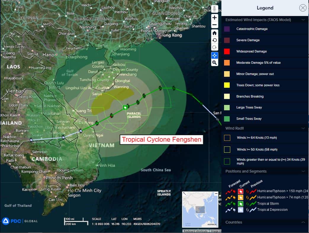
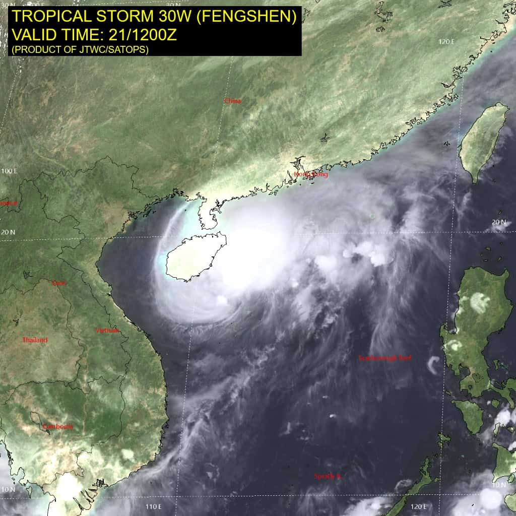
Tropical Cyclone 03W (Fengshen)…is located approximately 214 NM east-northeast of Da Nang, Vietnam
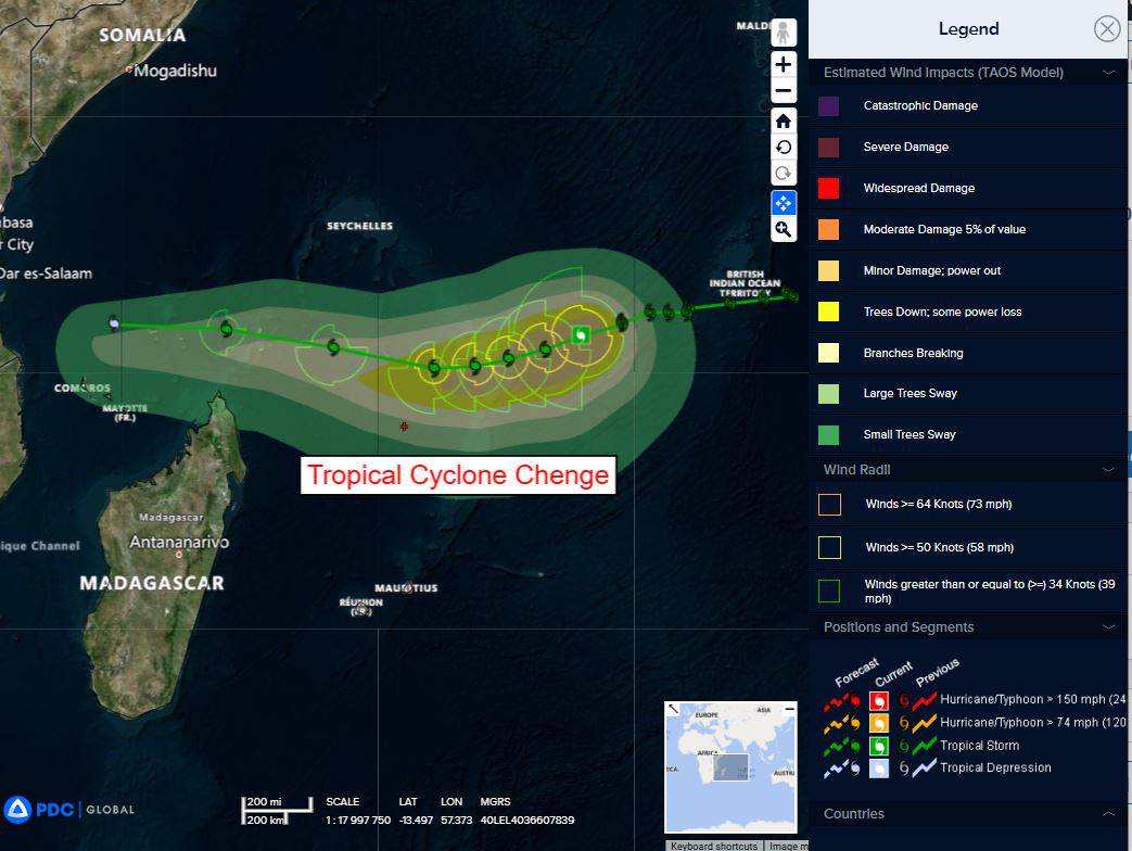
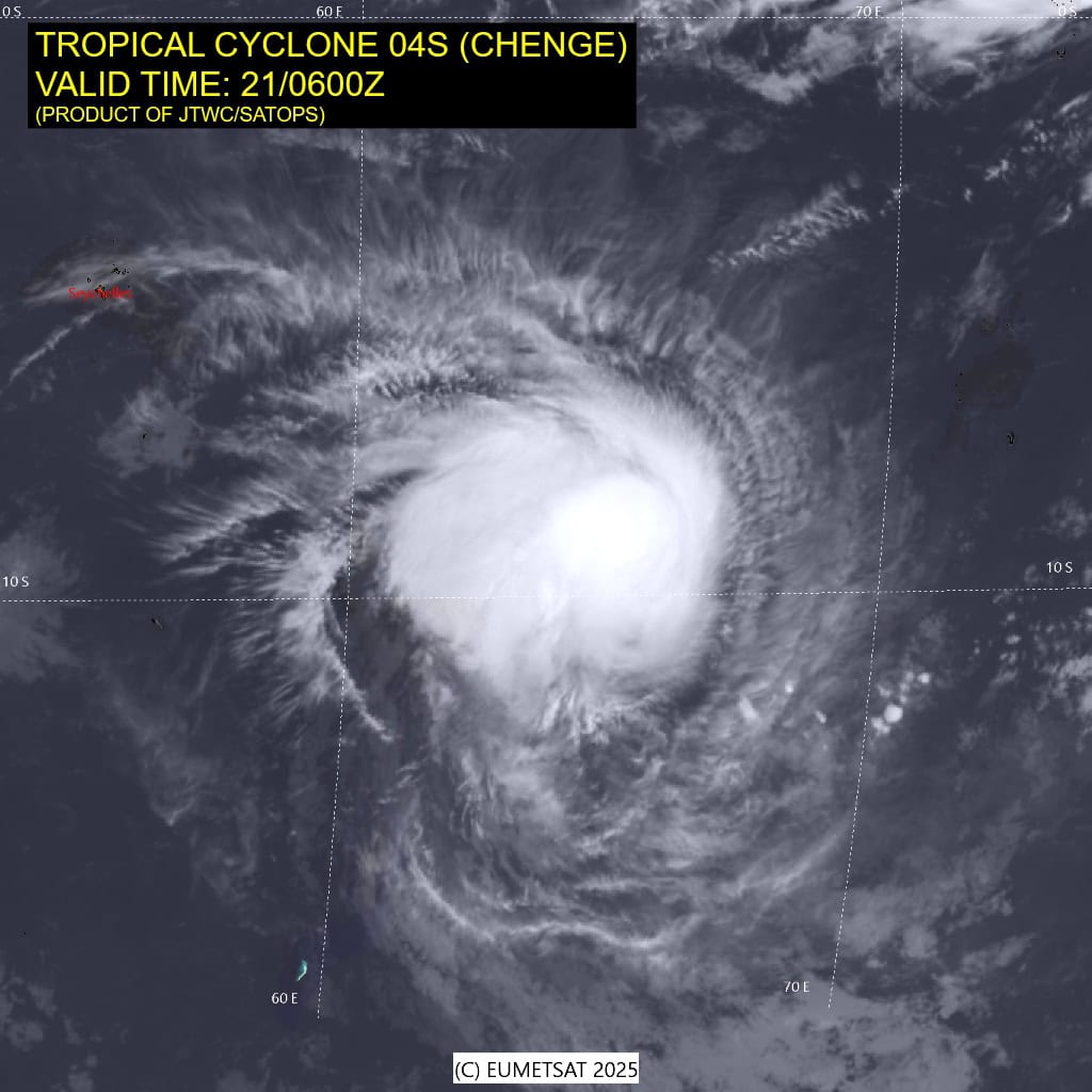
Tropical Cyclone 04S (Chenge)…is located approximately 520 NM west-southwest of Diego Garcia
Northeast Pacific Ocean: There are no Tropical Cyclones
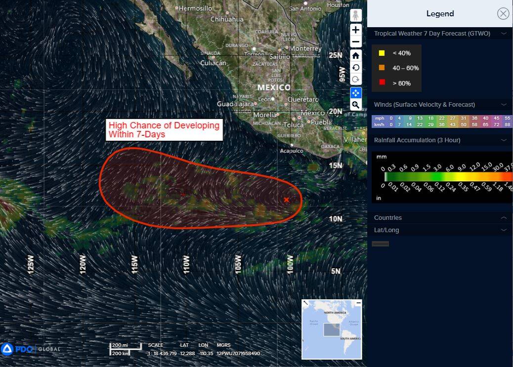
Central East Pacific:
>>> A tropical wave located several hundred miles south of the coast of southwestern Mexico is producing disorganized showers and thunderstorms. Environmental conditions appear conducive for gradual development of this system, and a tropical depression is likely to form late this week or over the weekend while it moves generally westward at 10 to 15 mph.
* Formation chance through 48 hours…low…30 percent
* Formation chance through 7 days…high…70 percent
Central Pacific Ocean: There are no Tropical Cyclones
Tropical cyclone formation is not expected during the next 7 days.
Western Pacific, Indian Ocean, and adjacent Seas:
Western Pacific
Tropical Cyclone 03W (Fengshen)
According to the JTWC warning number 17, sustained winds are 45 knots with gusts to near 55 knots
Tropical storm 30W (Fengshen) is still being steered by the subtropical ridge (str) to the northwest, while the circulation is interacting with the cooler and more dry air brought by the cold surge event occurring along the coastline of China. This interaction can be seen via enhanced convection and slowing of the system over the past 6 hours depicted on animated enhanced infrared (eir) satellite imagery.
Environmental conditions remain marginal with vertical wind shear at 15-20 kts, sea surface temperatures between 27 c and 28 c, as well as moderate outflow. a significant amount of dry air surrounds the system, slowly beginning to enter the core of the circulation.
TS Fengshen will continue tracking west-southwestward driven by the subtropical ridge to the northwest. Over the next 12 hours the storm is expected to meet stronger resistance from the cold surge to the west. Around 24 hours this interaction will have slowed down and pushed TS Fengshen further southwest.
The cool and dry air of the surge will also continue to be dragged into the circulation, causing weakening as the storm approaches the coast of Vietnam. Following the landfall, TS Fengshen will proceed to dissipate and is expected to weaken below 25 kts shortly after 48 hours.
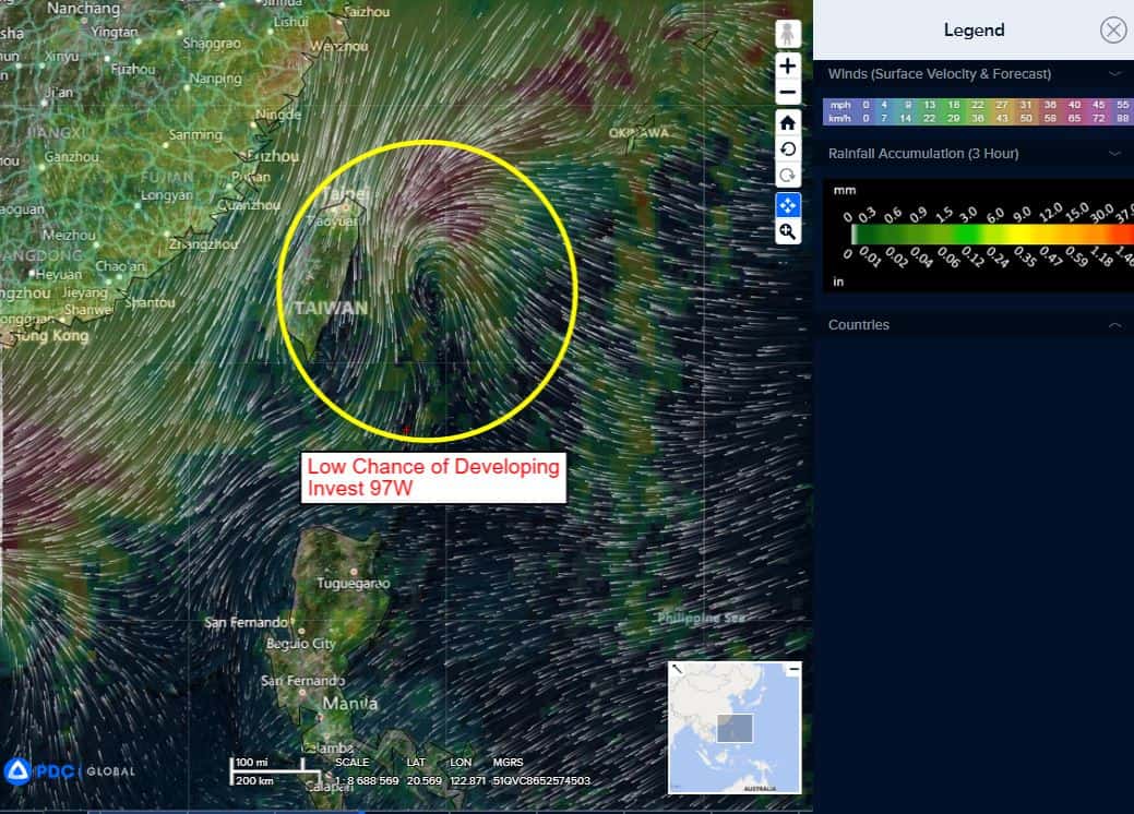
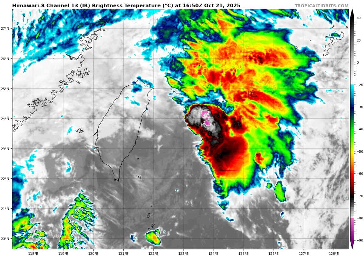
>>> There’s an area of disturbed weather being referred to as Invest 97W…which is located approximately 156 NM east of Kaohsiung, Taiwan
Animated enhanced multi-spectral satellite imagery (msi) depicts a partially exposed low level circulation center (llcc) with flaring convection. A 10210042z ascat reveals a wave like feature passing Ishigakijima, with the strongest winds of 25-30 knots passing south along the northern periphery associated with the eastern edge of a strong cold-surge event.
Environmental analysis for the area indicates marginal conditions for development with high vertical wind shear (25-30 kts), with warm sea surface temperatures (29-30 c) and good equatorward outflow aloft.
Global models depict the wave feature pushing west and interacting with the cold surge flow, pulling gale-force northerly winds southward along the eastern side of Taiwan and wrapping into the cusp, eventually helping to close it off into a circulation center.
The gfs is the most aggressive in developing this system, tracking south-east of Taiwan over the next 24-36 hours. The other global models and the gefs and ecens ensembles also show this wave and subsequent interactions with the northeasterly surge but are less aggressive than the gfs.
Maximum sustained surface winds are estimated at 18 to 23 knots.
The potential for the development of a significant tropical cyclone within the next 24 hours is upgraded to medium.
South Indian Ocean
Tropical Cyclone 04S (Chenge)
According to the JTWC warning number 12, sustained winds are 60 knots with gusts to near 75 knots
Tropical cyclone 04S (Chenge) has been able to maintain its intensity despite encountering a significant amount of vertical wind shear (20-25 kts). Animated enhanced infrared (eir) satellite imagery depicts persistent deep convection especially in the northwestern quadrant of the circulation.
Environmental analysis reveals dry air surrounding the circulation and entering the vortex from the north and east.
Tropical cyclone 04S (Chenge) is expected to continue tracking generally westward over the next 72 hours as it is pushed by the subtropical ridge to the southeast. Afterwards a competing steering mechanism, resulting from a building ridge east of Madagascar, will cause the track to shift more north-northwestward for the remainder of the forecast.
Although the system is holding well for now, strong vertical wind shear and continuous dry air entrainment will whittle down the intensity and lead to full dissipation prior to 120 hours.
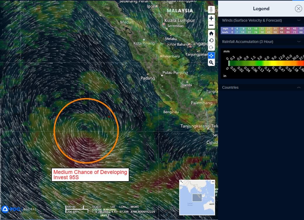
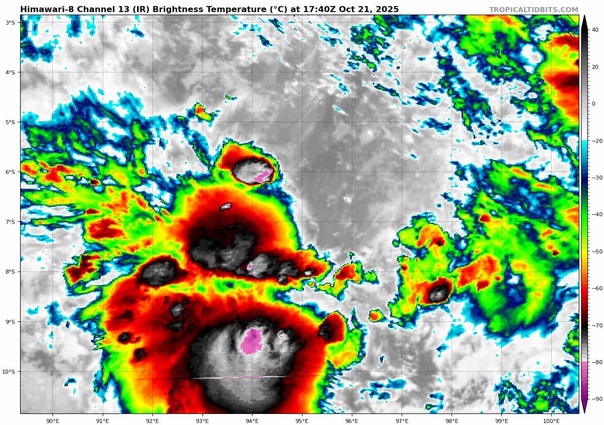
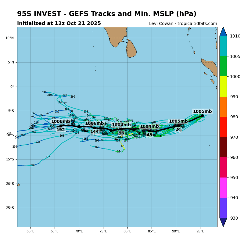
>>> There’s an area of disturbed weather being referred to as Invest 95S…which is located approximately 377 NM north-northwest of Cocos Islands.
Animated enhanced infrared imagery (eir) and a 201434z metop-c ascat pass depict a broad circulation with associated deep convection near the low-level circulation center and over the southwestern periphery.
Environmental analysis reveals marginal conditions for development with moderate to high vertical wind shear (15-20 kts), strong poleward outflow, and warm sea surface temperatures (29-30 c).
Global deterministic and ensemble models predict slow development as invest 95S turns from a poleward to southwestward trajectory over the next 24-48 hours.
Maximum sustained surface winds are estimated at 23 to 27 knots.
The potential for the development of a significant tropical cyclone within the next 24 hours remains medium.
Arabian Sea
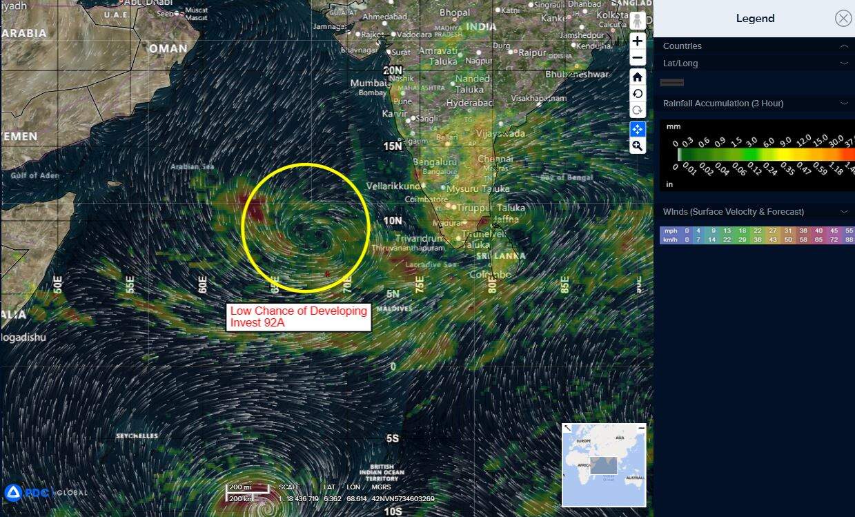
>>> There’s an area of disturbed weather being referred to as Invest 92A…which is located approximately 684 NM south-southwest of Mumbai, India
Animated enhanced infrared imagery (eir) and a 211654z metop-b ascat pass depict a broad and poorly organized circulation embedded within flaring convection in the northwestern periphery.
Environmental analysis reveals marginally favorable conditions, with warm (28-29 c) sea surface temperatures and westward and poleward outflow aloft offset by moderate to high (20-25 kts) easterly vertical wind shear.
Global deterministic models show a very slow and gradual development over time, with the navgem solution the most distinct and fastest. Ensemble models are in general agreement regarding a gradual build in the wind speed up to 35 kts over the next several days.
Maximum sustained surface winds are estimated at 18 to 22 knots.
The potential for the development of a significant tropical cyclone within the next 24 hours is low.