
")
Current Snapshot
For all the latest updates visit: DisasterAWARE
1800×1080
epac2
epac7
feng
30W_201200sair
himawari8_ir_30W_202510201510_lat18.5-lon114.2
30W_tracks_latest
chenge
04S_200600sair
meteosat9_ir_04S_202510201536_lat-8.9-lon67.1
04S_tracks_latest
97w
himawari8_ir_97W_202510201510_lat24.2-lon124.5

97W_tracks_latest
95s
himawari8_ir_95S_202510201510_lat-3.5-lon97.7
95S_tracks_latest
By PDC’s Senior Weather
Specialist Glenn James

The Pacific Disaster Center’s (PDC Global) Monday, October 20, 2025, Tropical Cyclone Activity Report…for the Pacific Ocean, the Indian Ocean, and adjacent Seas
Current Tropical Cyclones:
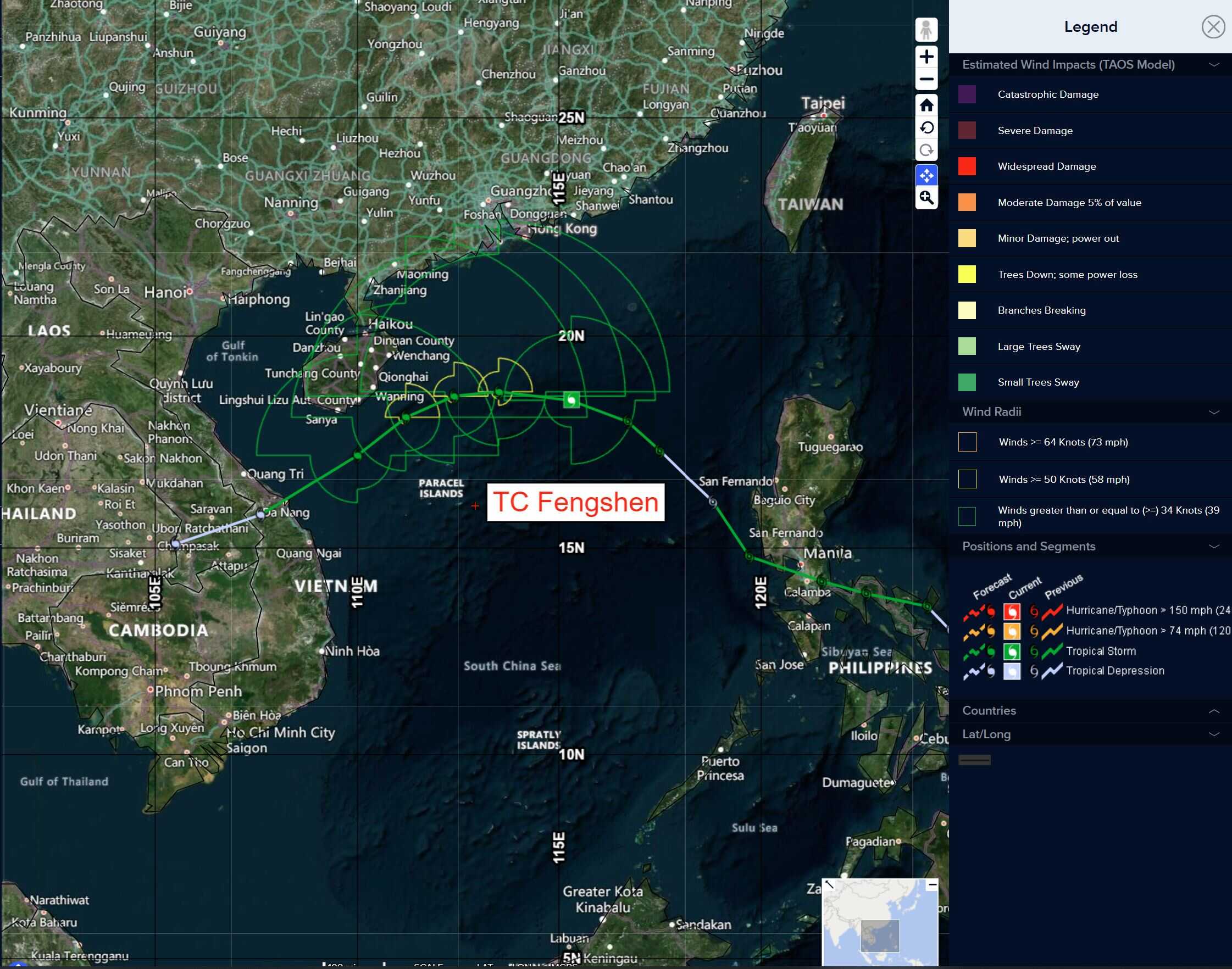
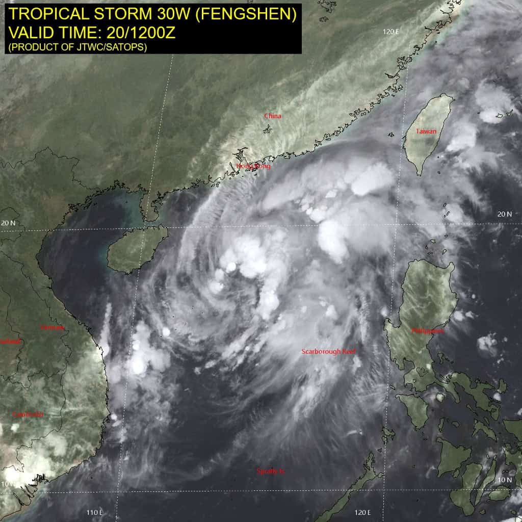
Tropical Cyclone 03W (Fengshen)…is located approximately 228 NM south of Hong Kong
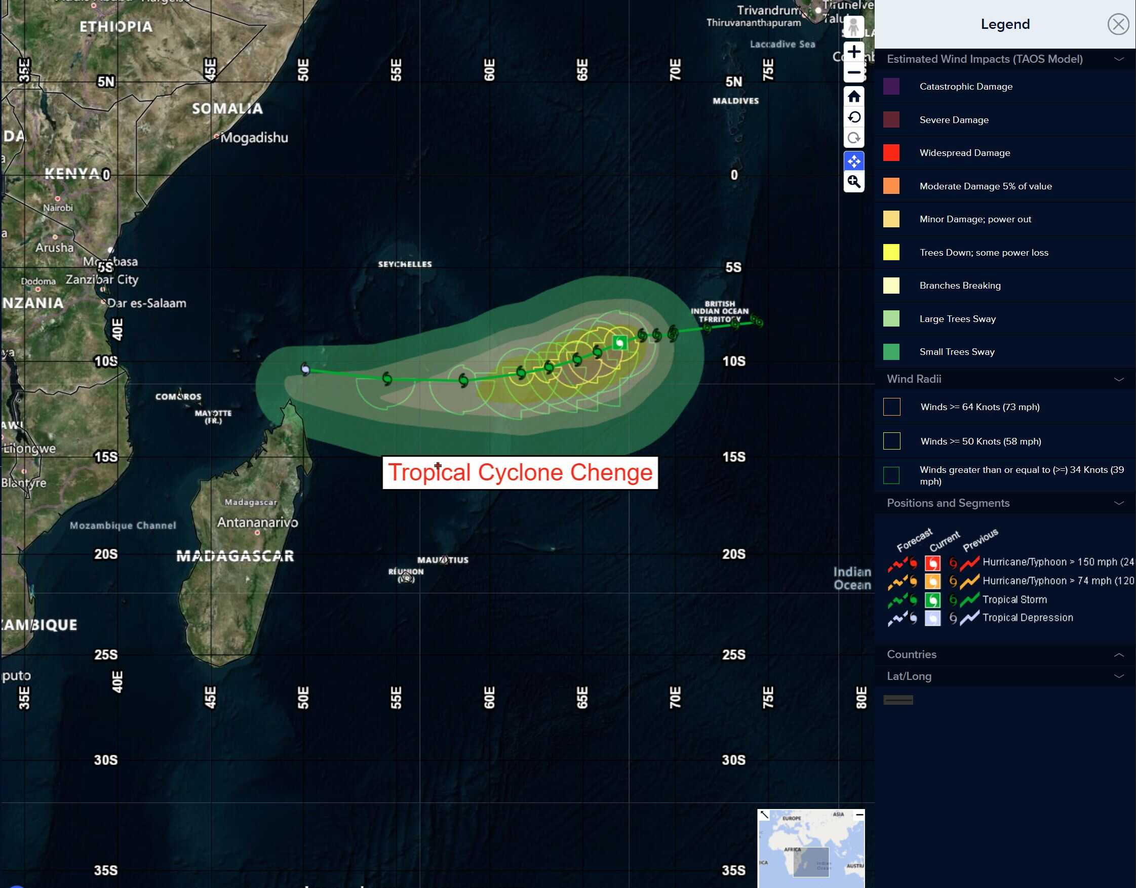
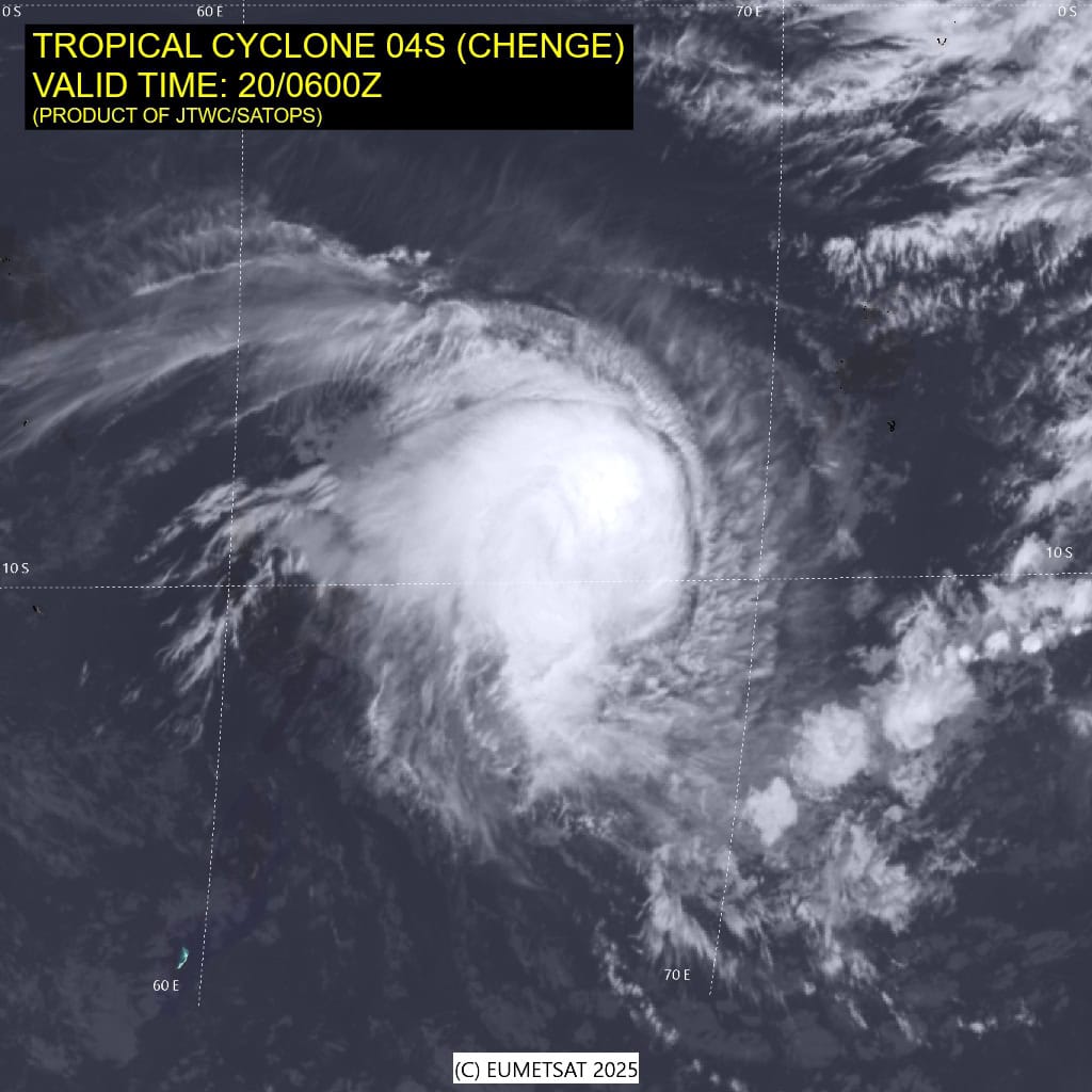
Tropical Cyclone 04S (Chenge)…is located approximately 346 NM west-southwest of Diego Garcia
Northeast Pacific Ocean: There are no Tropical Cyclones
Central East Pacific:
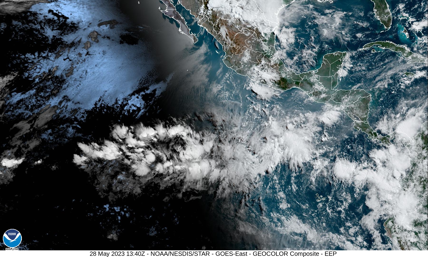
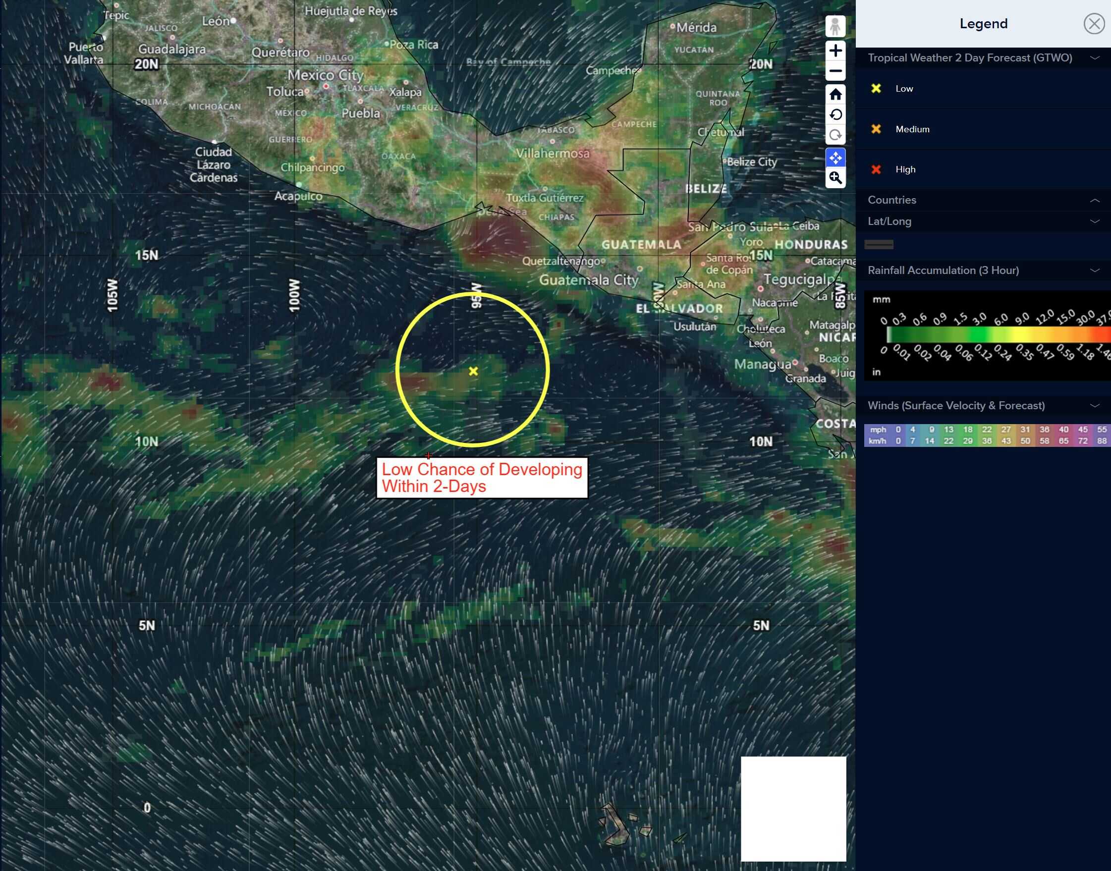
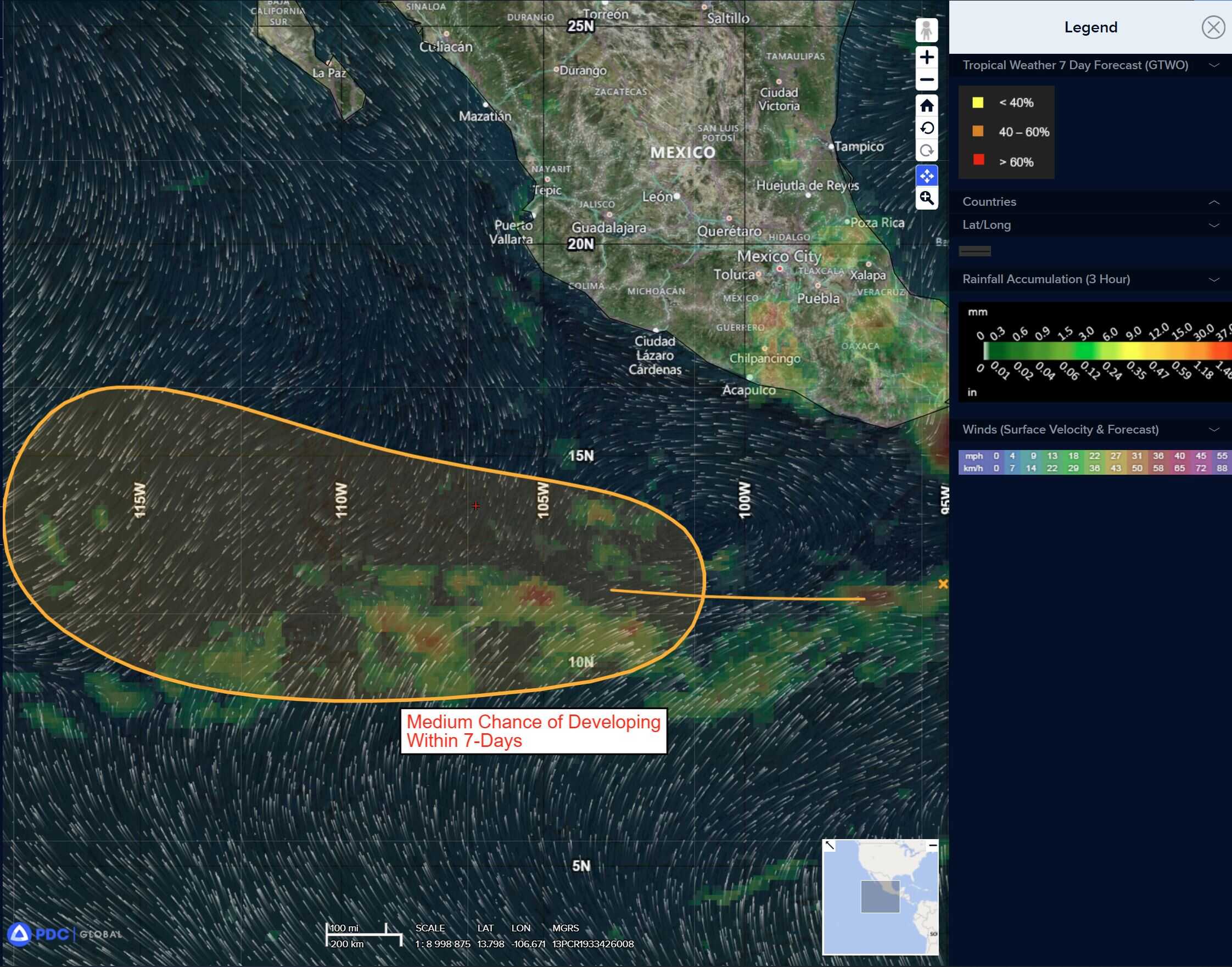
>>> A surface trough located near the Gulf of Tehuantepec continues to produce disorganized showers and thunderstorms.
Gradual development of the system is possible, and a tropical depression could form in a few days as it moves generally westward at 10 to 15 mph, remaining off the coast of Mexico.
* Formation chance through 48 hours…low…10 percent
* Formation chance through 7 days…medium…50 percent
Central Pacific Ocean: There are no Tropical Cyclones
Tropical cyclone formation is not expected during the next 7 days.
Western Pacific, Indian Ocean, and adjacent Seas:
Western Pacific
Tropical Cyclone 03W (Fengshen)
According to the JTWC warning number 11, sustained winds are 45 knots with gusts to near 55 knots
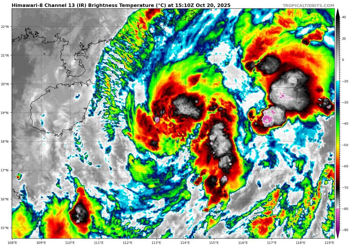
Animated enhanced infrared (eir) satellite imagery depicts a rather disorganized appearance, as tropical storm 30W continues to struggle to organize and intensify. Over the past six hours, convective activity has weakened and become more fragmented, though in the last hour or two, deep convection has begun to reform near the center but remains disorganized.
A 201006z wsf-m color-enhanced 89ghz image revealed fragmentary convective bands wrapping into an ill-defined low level circulation center (llcc). The strongest convection remains positioned to the east and northeast of the llcc, due to persistent moderate southerly shear.
Ship observations east of Hong Kong indicate very strong north-easterly flow is pushing southwestward to the west of TS 30W, with animated eir suggesting these strong winds extend all the way to Hainan. Animated water vapor imagery shows strong poleward outflow and moderate equatorward outflow aloft. the
Environment is about as good as it’s going to be right now, with strong poleward outflow, warm ssts, a pool of relatively high ohc right along the track, and low southerly shear.
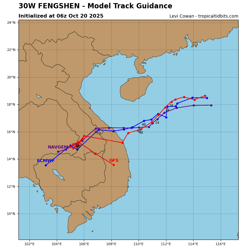
The track of TS 30W has already flattened out and the system is now tracking due west, along the southern side of an extension of the str positioned over southeastern china. The system is forecast to continue tracking westward for the next 12 hours, before making a sharp southwestward turn as it comes under
the steering influence of a building ridge over northern Vietnam.
Additional support for the trajectory change will come from the bumper effect of the strong, gale-force, northeasterlies trapped
between the storm and the Chinese coast. After briefly slowing down as it runs into the northeasterly flow, TS 30W will accelerate southwestward towards the Vietnamese coast, where it is expected to make landfall in the vicinity of Da Nang around 60 hours.
Most likely due to the persistence of the southerly shear, TS 30W has failed to organize quickly enough to be able to intensify at the rate originally expected. the window of opportunity remaining for it to intensify is rapidly closing, and there remains only about 24 hours of favorable conditions to support intensification. Thus, the peak intensity is forecast to only reach 55 knots at 24 hours, before the onset of rapid weakening induced by an influx of dry mid-level air and increasing shear as it makes its hard left turn.
By 48 hours, as it is approaching the Vietnamese coast, the system will be completely smothered in dry air above 700mb, be devoid of significant convection and rapidly dying off. at landfall the system will be a minimal tropical storm or strong tropical
depression and will dissipate over southern Laos no later than 72 hours.
South Indian Ocean
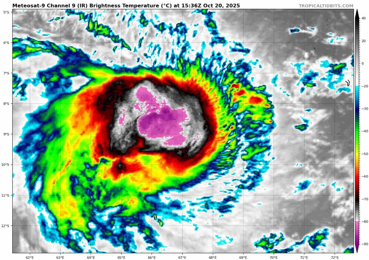
Tropical Cyclone 04S (Chenge)
According to the JTWC warning number 9, sustained winds are 50 knots with gusts to near 65 knots
Tropical cyclone 04S steadily intensified over the past day, and the presentation in the animated multi-spectral satellite imagery (msi) is much improved. The previously exposed low level circulation center (llcc) appears to have tucked up under a developing cdo feature. The most recent microwave imagery from a 200227z ssmis pass shows that the llcc was still exposed to the east of the developing convection at that time, with low-level banding features evident to the east in the drier air that is present in that hemisphere.
Animated water vapor imagery and cimss amv analysis indicate that the convection is successfully pushing back against the persistent easterly shear, at least at the outflow layer around 200mb. The amvs show the flow splitting as it meets the outflow boundary, flowing both equatorward and poleward. This setup is causing a localized reduction in the deep-layer shear and
allowing TC 04S to become more symmetrized and to intensify.
Environmental conditions have become more favorable, with reduced shear, warm ssts and strong poleward and weaker equatorward outflow.
TC 04S has slowed down to about six knots of forward speed, and has shifted slightly more southwestward, as it moves through an area of weakened steering gradient induced by a
weakness in the ridge to the south. the weakness in the ridge will persist for another 12 to 24 hours before the ridge builds once more, allowing TC 04S to speed up a bit after 24 hours.
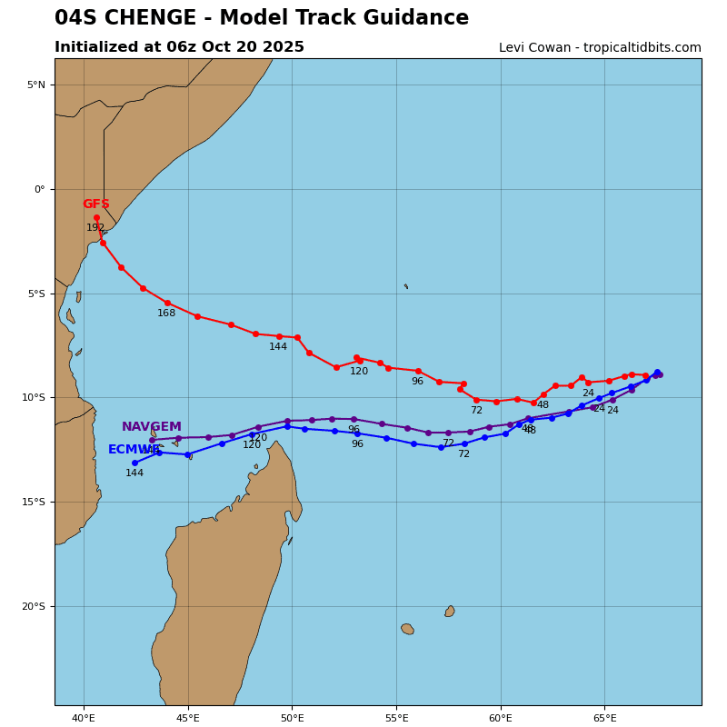
The global models, specifically gfs and ecmwf, depict two very different scenarios in the evolution of the ridge to the south. The gfs depicts a rapidly building ridge that moves quickly westward, while expanding northward. This results in a much slower track that pushes TC 04S northward towards the Seychelles by the end of the forecast.
The ecmwf, and the other members of the consensus, also depict the ridge building, but it moves west at a much slower rate and remains on a more east-west orientation, which allows TC 04S to track generally westward after 48 hours, passing north of the northern tip of Madagascar.
Analysis of the upper-level fields indicates that the ecmwf is initializing better, and this forecast scenario is currently favored, with TC 04S forecast to track west-southwest through 48 hours, then westward through the end of the forecast period.
The system has clearly become more organized and the vortex has apparently been able to symmetrize and align vertically, setting up a period of intensification. This trend is expected to continue for at least the next 12 hours or so, and the forecast calls for TC 04S to intensify up to 55 knots, with the possibility that it could make a run at 60 knots with the next 24 hours.
After 24 hours, shear increases sharply, and dry air is forecast to push in and engulf the system, which will lead to a steady weakening trend through the remainder of the forecast. Dissipation below warning criteria is forecast by 120 hours.
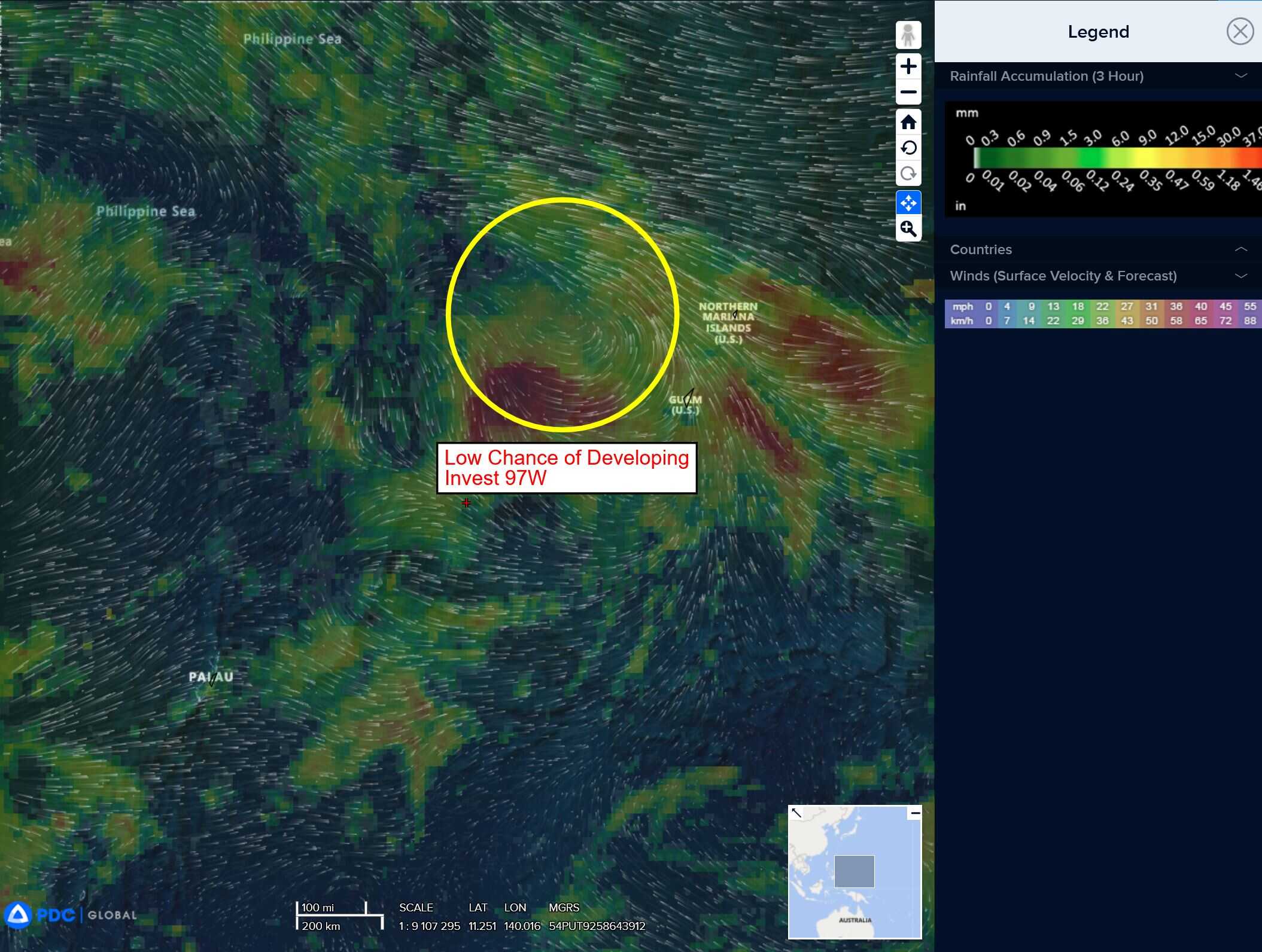
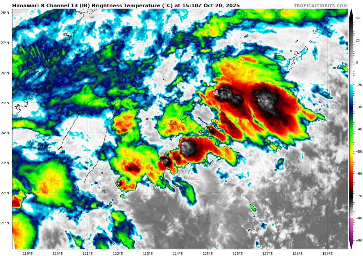
>>> There’s an area of disturbed weather being referred to as Invest 97W…which is located approximately 20 NM south-southeast of Ishigakijima.
Enhanced infrared satellite imagery (eir) depicts an area of flaring convection with no defined low-level circulation center. A partial ascat 10201213z pass reveals a wave feature passing Ishigakijima, with the strongest winds of 25-30 knots along the northern periphery, associated with the eastern edge of a strong cold-surge event.
Environmental analysis reveals marginal conditions for development with moderate vertical wind shear (20-25 knots), diffluent outflow aloft, and warm sea surface temperatures (29-30 c).
Global models depict the wave feature pushing west and interacting with the cold surge flow, pulling gale-force northerly winds southward along the eastern side of Taiwan and wrapping into the cusp, eventually helping to close it off into a circulation center.
The gfs is the most aggressive in developing this system, tracking south-east of Taiwan over the next 24-36 hours. The other global models and the gefs and ecens ensembles also show this wave and subsequent interactions with the northeasterly surge but are less aggressive than the gfs.
Maximum sustained surface winds are estimated at 18 to 23 knots.
The potential for the development of a significant tropical cyclone within the next 24 hours is low.
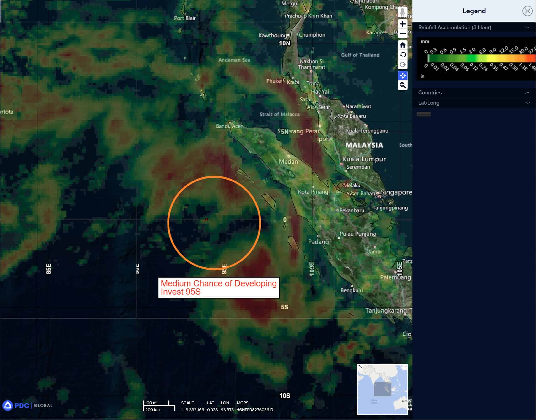
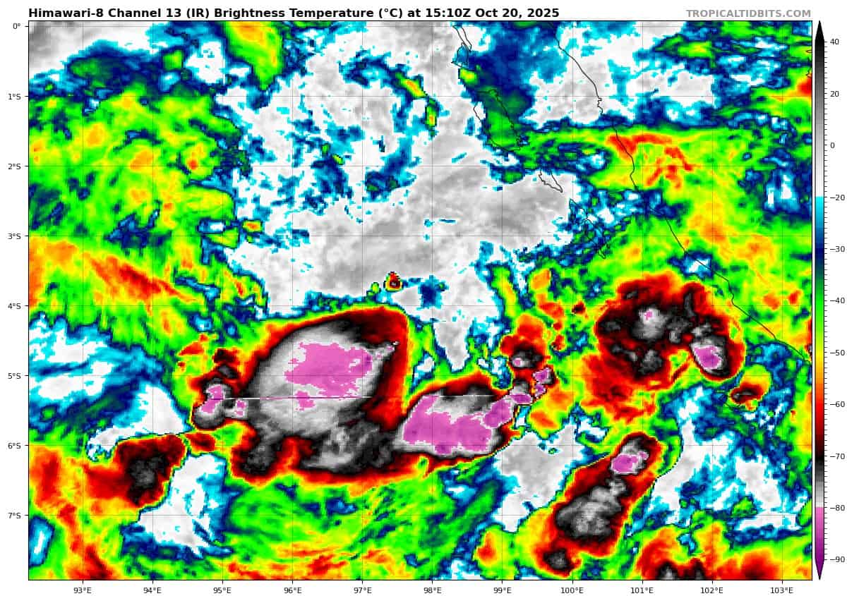
>>> There’s an area of disturbed weather being referred to as Invest 95S…which is located approximately 686 NM north-northwest of Cocos Islands.
Animated multi-spectral imagery (msi) depicts a poorly organized, broad circulation, with a rapidly consolidating low level circulation center (llcc) embedded within the northern portion of the larger rotation. Deep convection can be seen flaring up near the llcc, as well as across the southern side of the circulation.
An ascat-b 200230z pass reveals a small, but well-defined, symmetrical llcc with 25 knot winds wrapping around the majority of the circulation, with the highest winds present in the northeastern sector, trapped along the island offshore of western Sumatra.
Environmental analysis reveals marginal conditions for development with moderate to high vertical wind (20-25 knots), strong diffluent poleward outflow, and warm sea surface temperatures (29-30 c).
Global models are in fair agreement that invest 95S will continue
to have general steady development with a curving south to southwestern track within the next 24-48 hours.
Maximum sustained surface winds are estimated at 18 to 23 knots.
The potential for the development of a significant tropical cyclone within the next 24 hours is upgraded to medium.