
")
Current Snapshot
For all the latest updates visit: DisasterAWARE
Sonia
goes18_ir_18E_202510261445_lat13.6-lon-119.8
18E_tracks_latest
03b

03B_261200sair

03B_tracks_latest
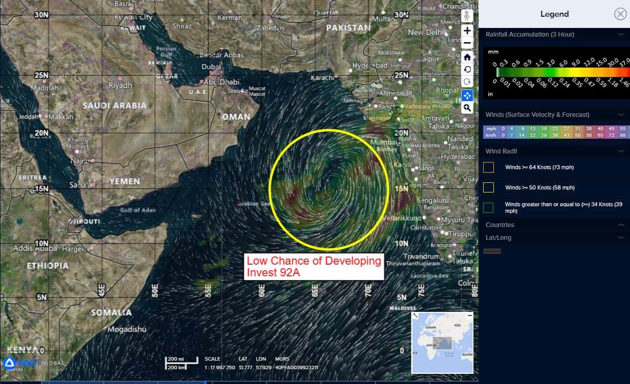
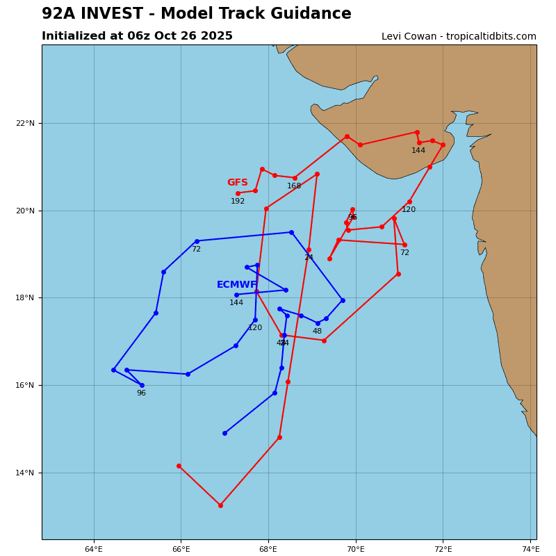
92a

meteosat9_ir_92A_202510261451_lat15.3-lon66.8
92A_tracks_latest
By PDC’s Senior Weather
Specialist Glenn James

The Pacific Disaster Center’s (PDC Global) Sunday, October 26, 2025, Tropical Cyclone Activity Report…for the Pacific Ocean, the Indian Ocean, and adjacent Seas
Current Tropical Cyclones:
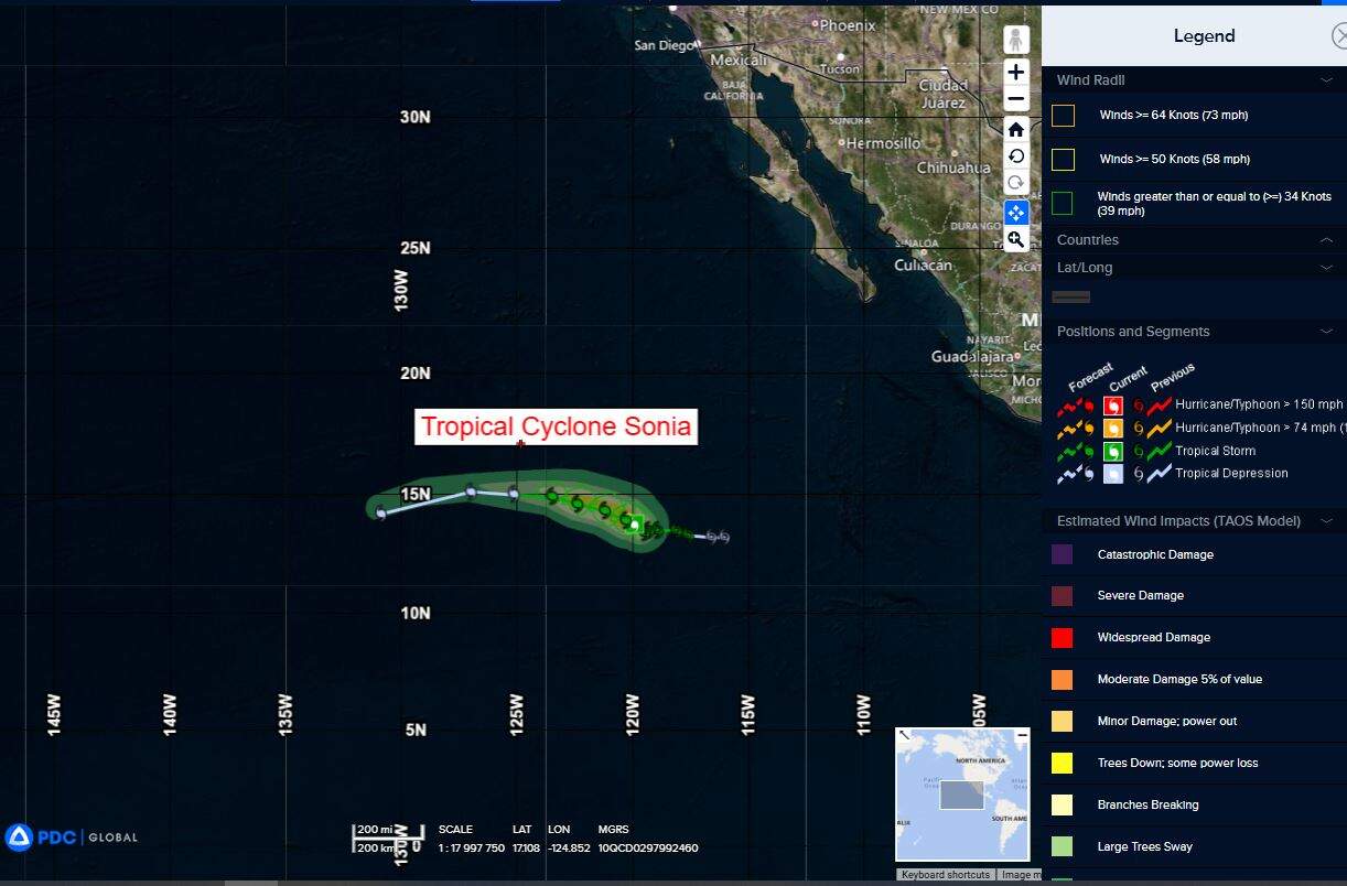
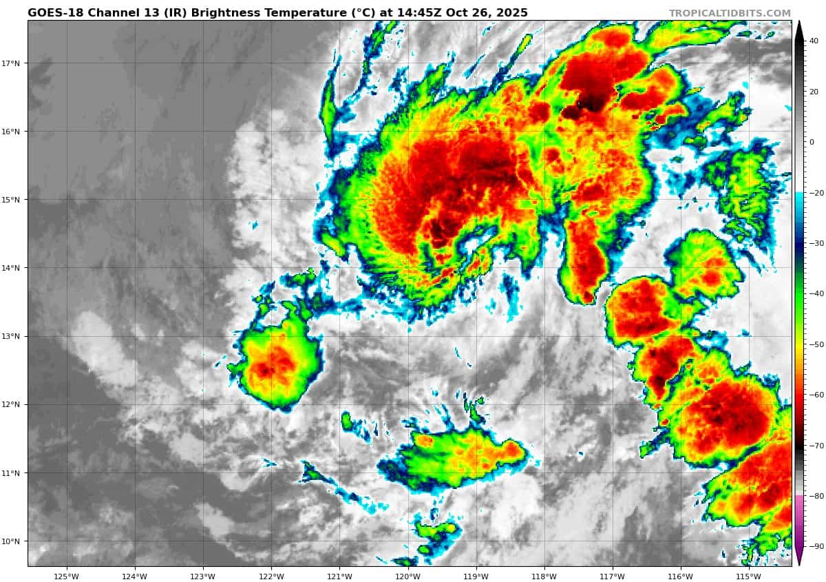
Tropical Cyclone 18E (Sonia)…is located approximately 910 miles southwest of the southern tip of Baja California
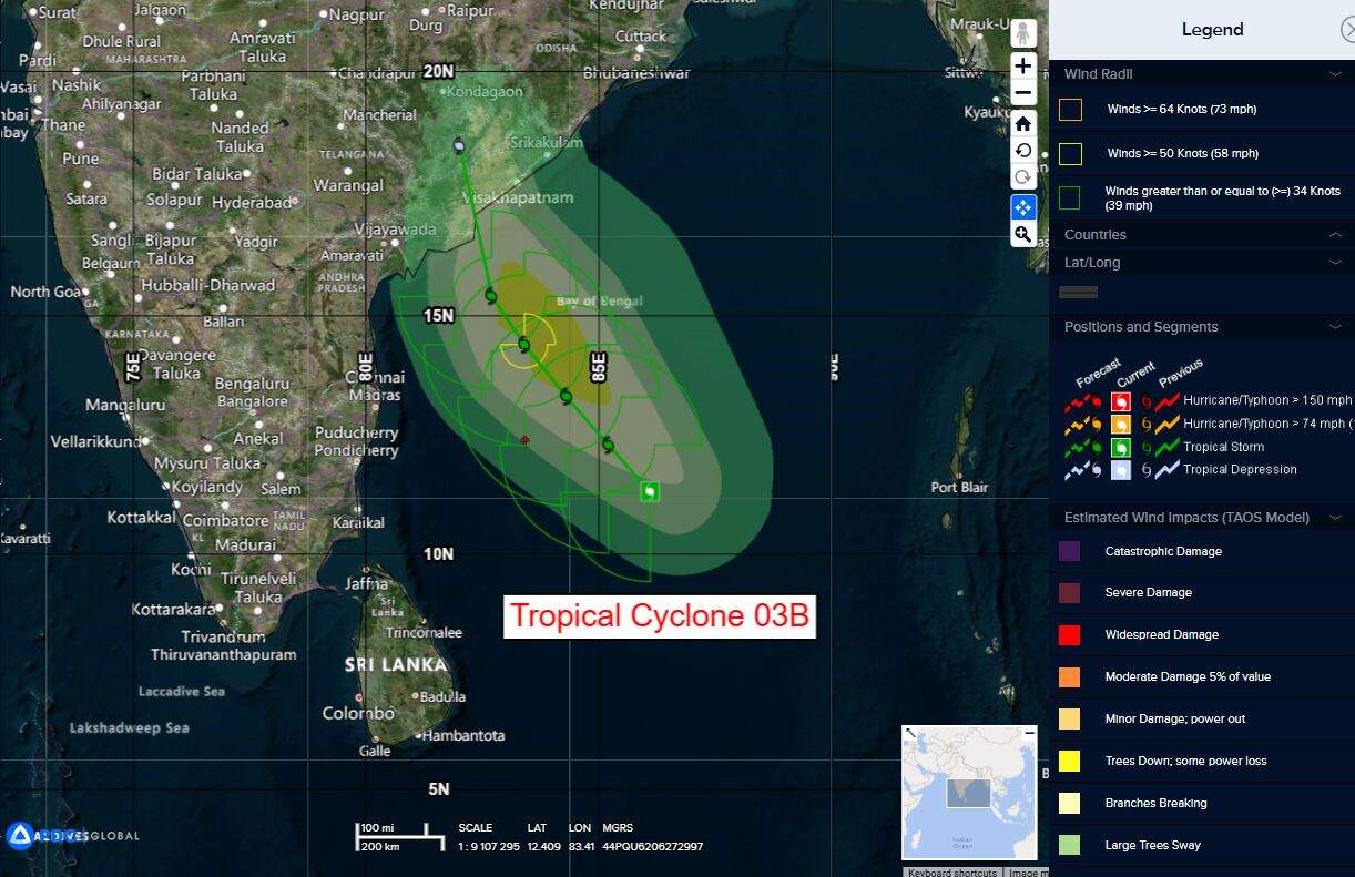
Tropical Cyclone 03B Montha…is located approximately 631 NM south-southwest of Kolkata, India
Northeast Pacific Ocean:
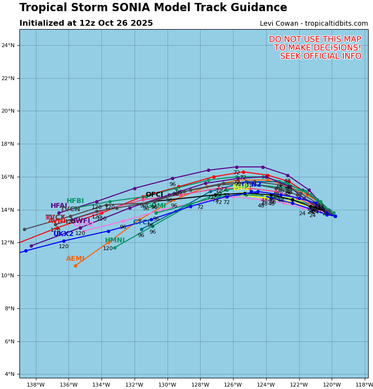
Tropical Cyclone 18E (Sonia)
SONIA HOLDING STEADY
According to the NHC advisory number 10
Sonia is moving toward the west-northwest near 6 mph (9 km/h). A gradual turn toward the west is expected by Tuesday.
Maximum sustained winds are near 45 mph (75 km/h) with higher gusts. Gradual weakening is forecast during the next couple of days, and Sonia is expected to become a post-tropical remnant low by late Tuesday.
Tropical-storm-force winds extend outward up to 45 miles (75 km) from the center. The estimated minimum central pressure is 1004 mb (29.65 inches).
Central Pacific Ocean: There are no Tropical Cyclones
Tropical cyclone formation is not expected during the next 7 days.
Western Pacific, Indian Ocean, and adjacent Seas:
North Indian Ocean
Tropical Cyclone 03B (Montha)
According to the JTWC warning number 3, sustained winds are 40 knots with gusts to near 50 knots
Tropical cyclone 03B has been slowly tracking to the west under the influence of a subtropical ridge to the north. over the past 6 hours the circulation has gained speed moving at 09 kts and the associated convection has improved as evidenced by the cooler
temperatures depicted by animated enhanced infrared (eir) satellite imagery. Convective activity is displaced well to the west due to high (25-30 kts) easterly vertical wind shear (vws).
Environmental conditions are marginally favorable for development with warm sea surface temperatures (28 c to 29c), moist atmospheric column and strong westward outflow, offset by high vws.
TC 03B is a weak circulation that lacks the ingredients to undergo any significant development. The cyclogenesis is currently being pushed to the west by a subtropical ridge to the north. As the str begins to retrograde within the next few hours, it will allow TC 03B to undergo a northwestward turn for the
remainder of the forecast period.
The decreasing strength of the ridge will play a large role in determining how north the system will progress up the coast of India. Plenty of warm water and strong divergence aloft will let the circulation increase up to 50 kts strength by 36 hours. The continued effects of high vertical wind shear and relatively drier air to the north will cause TC 03B to begin weakening just before landfall.
TC 03B will begin its dissipation over water around 36 hours and is expected to fully dissipate over land by 72 hours.
Arabian Sea
>>> There’s an area of disturbed weather being referred to as Invest 92A…which is located approximately 409 NM west-southwest of Mumbai, India
Animated enhanced multi-spectral imagery (msi) depicts flaring convection in the western periphery along a poorly organized low level circulation center (llcc).
Environmental analysis for the area indicates favorable conditions for development with moderate vertical wind shear (15-20 kts), warm sea surface temperatures (28-29 c), and good equatorward outflow aloft.
Global deterministic and ensemble models are in agreement that 92A will continue north.
Maximum sustained surface winds are estimated at 18 to 23 knots.
The potential for the development of a significant tropical cyclone within the next 24 hours remains low.