
")
Current Snapshot
For all the latest updates visit: DisasterAWARE
30
1800x1080kk
wpac2
10W_231200sair
10W_tracks_latest
11W_231200sair
11W_tracks_latest
12W_231800sair

12W_tracks_latest
By PDC’s Senior Weather
Specialist Glenn James

The Pacific Disaster Center’s (PDC Global) Wednesday, July 23, 2025, Tropical Cyclone Activity Report…for the Pacific Ocean, the Indian Ocean, and adjacent Seas
Current Tropical Cyclones:
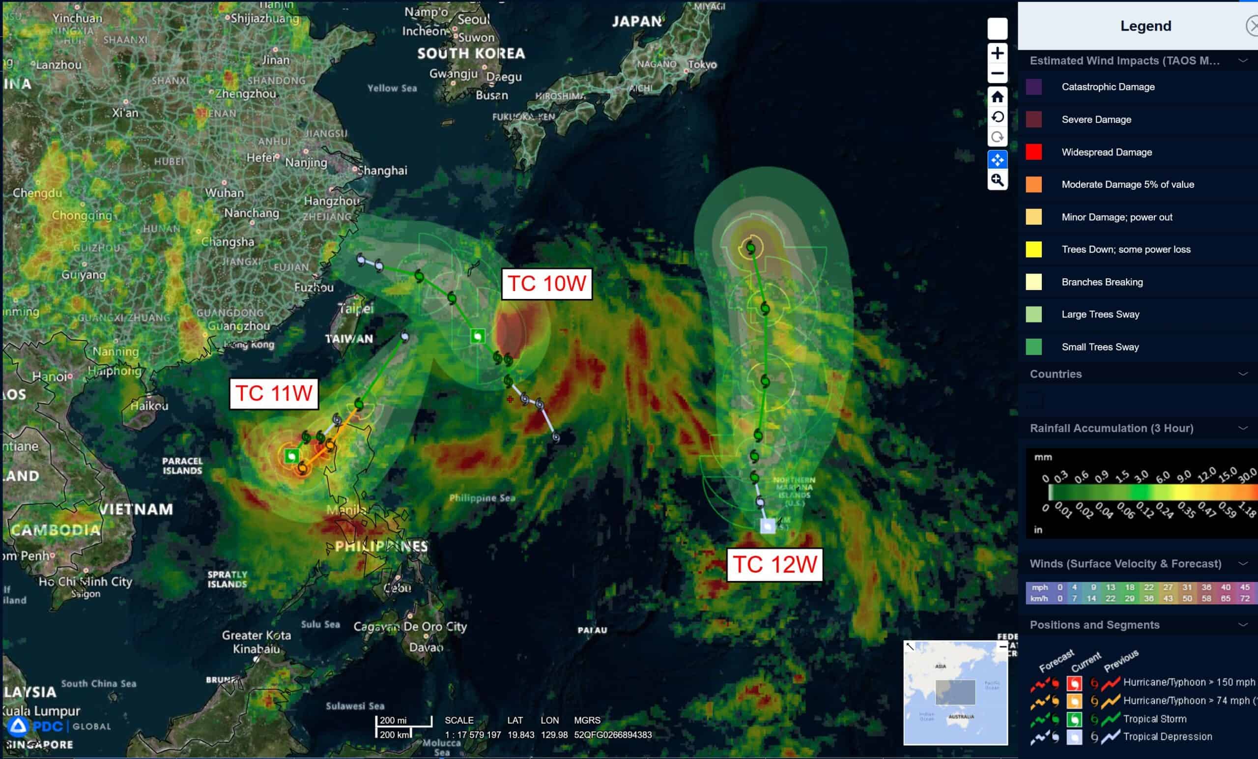
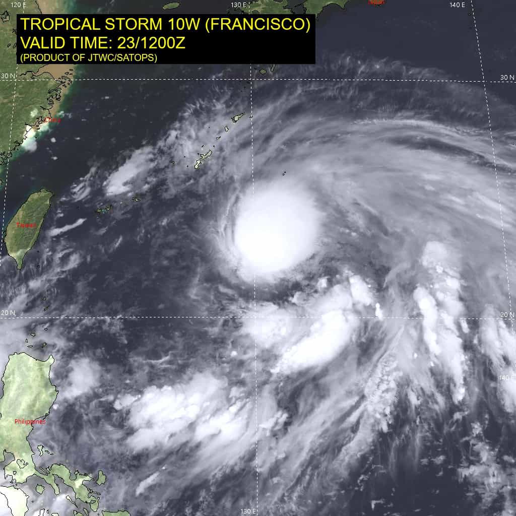
Tropical Cyclone 10W (Francisco)…is located 205 NM south of Kadena AB, Okinawa
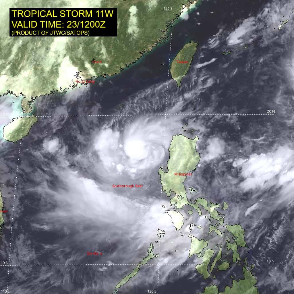
Tropical Cyclone 11W (Co-may)…is located 221 NM northwest of Manila, Philippines
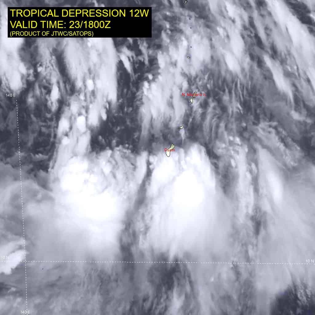
Tropical Cyclone 12W…is located 32 west-southwest of Navsta Guam
Northeast Pacific Ocean: There are no Tropical Cyclones
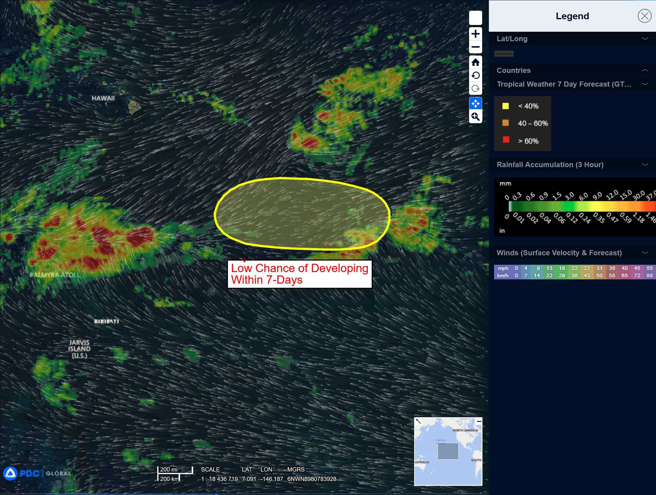
Well Southeast of the Hawaiian Islands:
An area of low pressure is expected to form well southeast of the Hawaiian Islands this weekend. Thereafter, some gradual development is possible as the system moves generally westward at 10 to 15 mph.
* Formation chance through 48 hours…low…near 0 percent
* Formation chance through 7 days…low…30 percent
Central Pacific Ocean: There are no Tropical Cyclones
Well Southeast of the Hawaiian Islands:
An area of low pressure is expected to form well southeast of the Hawaiian Islands this weekend. Thereafter, some gradual development is possible as the system moves generally westward at 10 to 15 mph.
* Formation chance through 48 hours…low…near 0 percent
* Formation chance through 7 days…low…30 percent
Western Pacific, Indian Ocean, and adjacent Seas:
Western Pacific
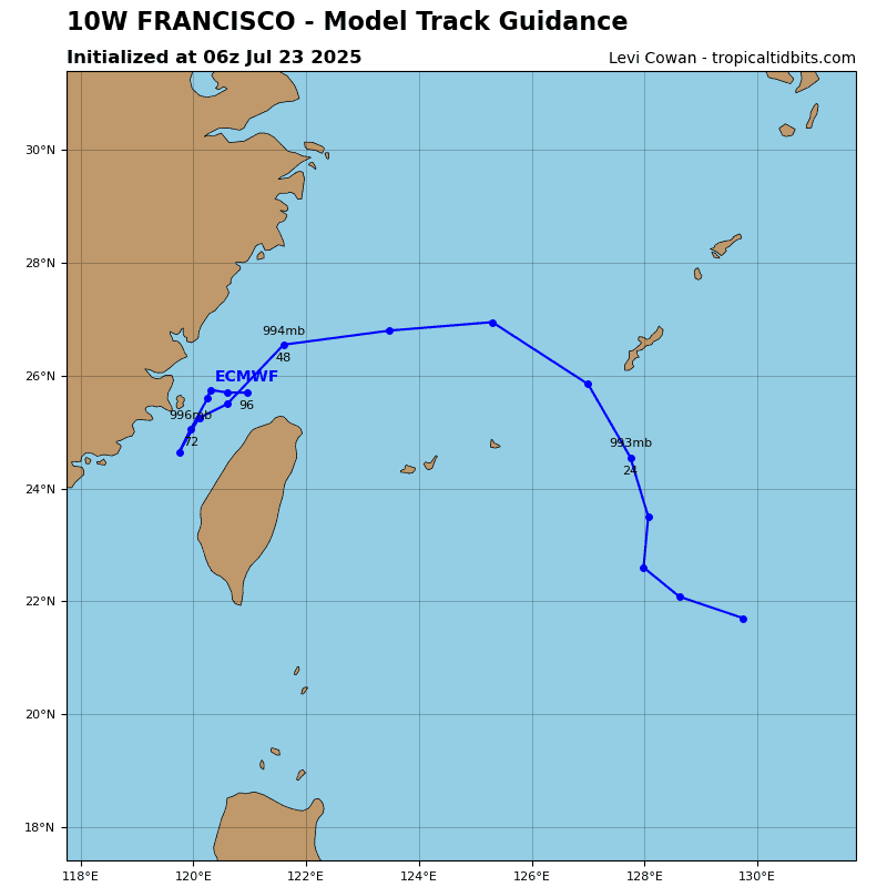
Tropical Cyclone 10W (Francisco)
According to the JTWC warning number 7 sustained winds are 40 knots with gusts to near 50 knots
Tropical storm 10W remains embedded within the northeastern periphery of a large low pressure area, which is forecast to gradually deepen and strengthen into a monsoon depression with expansive gale force winds over the next 24 to 48 hours. Animated enhanced infrared (eir) satellite imagery depicts deep convection building over a partially exposed low-level circulation center (llcc). A metop-c ascat image revealing the eastern periphery of circulation system with 35-40 knot wind speeds. A later metop-b ascat image captured the weaker western periphery. Water vapor imagery reveals strong poleward and equatorward outflow.
TS 10W will track northwestward along the southern periphery of the subtropical ridge to the north. Between 12-48 hours, TS 10W will round west-northwestward along the northern periphery of the large-scale monsoonal flow, which is expected to develop into a monsoon depression as TS 10W dissipates b 48 hours.
The environment is expected to remain favorable for the next 12 hours leading to a potential peak of 45 knots. After 12 hours, vertical wind shear is forecast to increase unfavorably, initiating weakening. The rate of weakening will continue as the system approaches an upper-level trough to the northwest, causing dry air entrainment and a degradation of the structure of ts 10W. TS 10W will begin dissipation into the monsoonal flow at 36 hours as the radius of maximum winds associated with the system becomes broad and the monsoonal flow wraps into a developing monsoon depression.
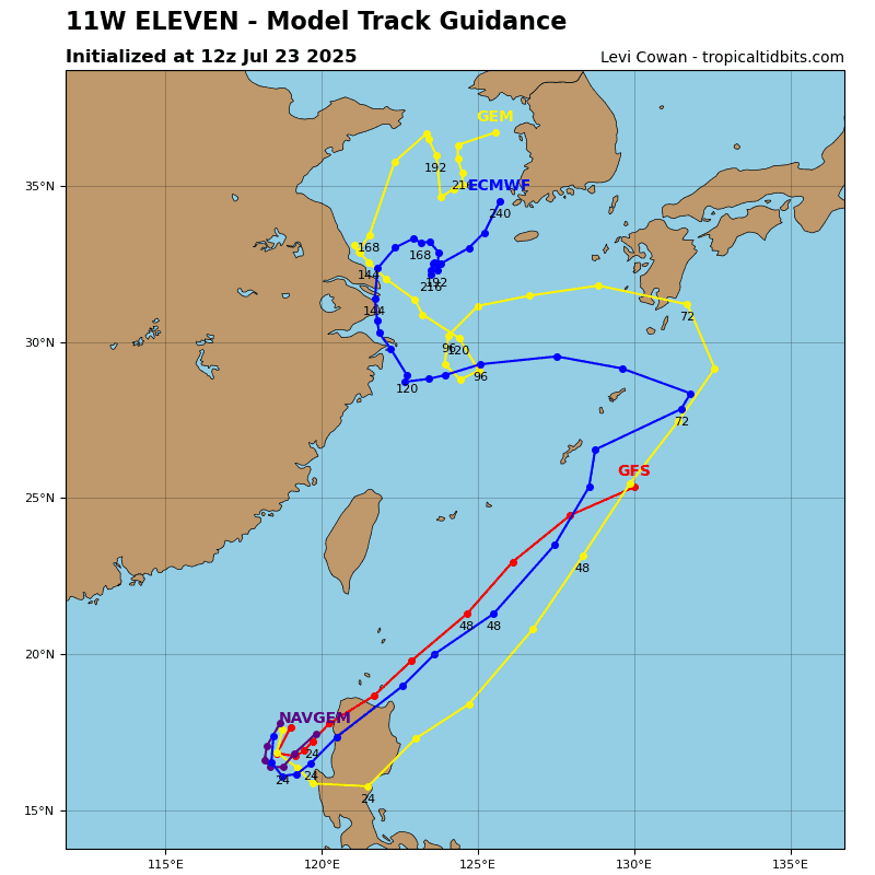
Tropical Cyclone 11W (Co-may)
According to the JTWC warning number 4 sustained winds are 60 knots with gusts to near 75 knots
Tropical storm 11W is located along the western periphery of a large, approximately 650 NM diameter low pressure area, which is forecast to gradually deepen and strengthen into a monsoon depression as it tracks poleward over the next few days. Animated multi-spectral satellite imagery (msi) depicts radial deep convection building over an obscured low-level circulation center (llcc). Animated eir confirms the cooling cloud tops of the central dense overcast convective mass, supporting the rate of intensification of tropical storm 11W. Water vapor imagery reveals enhanced favorable dual-channel outflow.
TS 11W is forecast to track southwestward over the next 12 hours before sharply curving in a cyclonic direction from 12-36 hours, passing over northern Luzon. After 36 hours, the system will become engulfed in the larger enhanced cyclonic flow, and ultimately dissipate into a developing monsoon depression by the end of the forecast period. Strong upper-level diffluence, low vertical wind shear, and warm sea surface temperatures allow for strong intensification to a peak of 60 knots at 36 hours. Topographic interaction with the mountainous terrain of northern Luzon will result in initiate weakening as TS 10W gets absorbed into the broader flow.
Tropical Cyclone 12W
According to the JTWC warning number 1 sustained winds are 25 knots with gusts to near 35 knots