
")
Current Snapshot
For all the latest updates visit: DisasterAWARE
2days
7

1800×1080
6666
09W_201200sair

97W_tracks_latest
By PDC’s Senior Weather
Specialist Glenn James

The Pacific Disaster Center’s (PDC Global) Sunday, July 20, 2025, Tropical Cyclone Activity Report…for the Pacific Ocean, the Indian Ocean, and adjacent Seas
Current Tropical Cyclones:
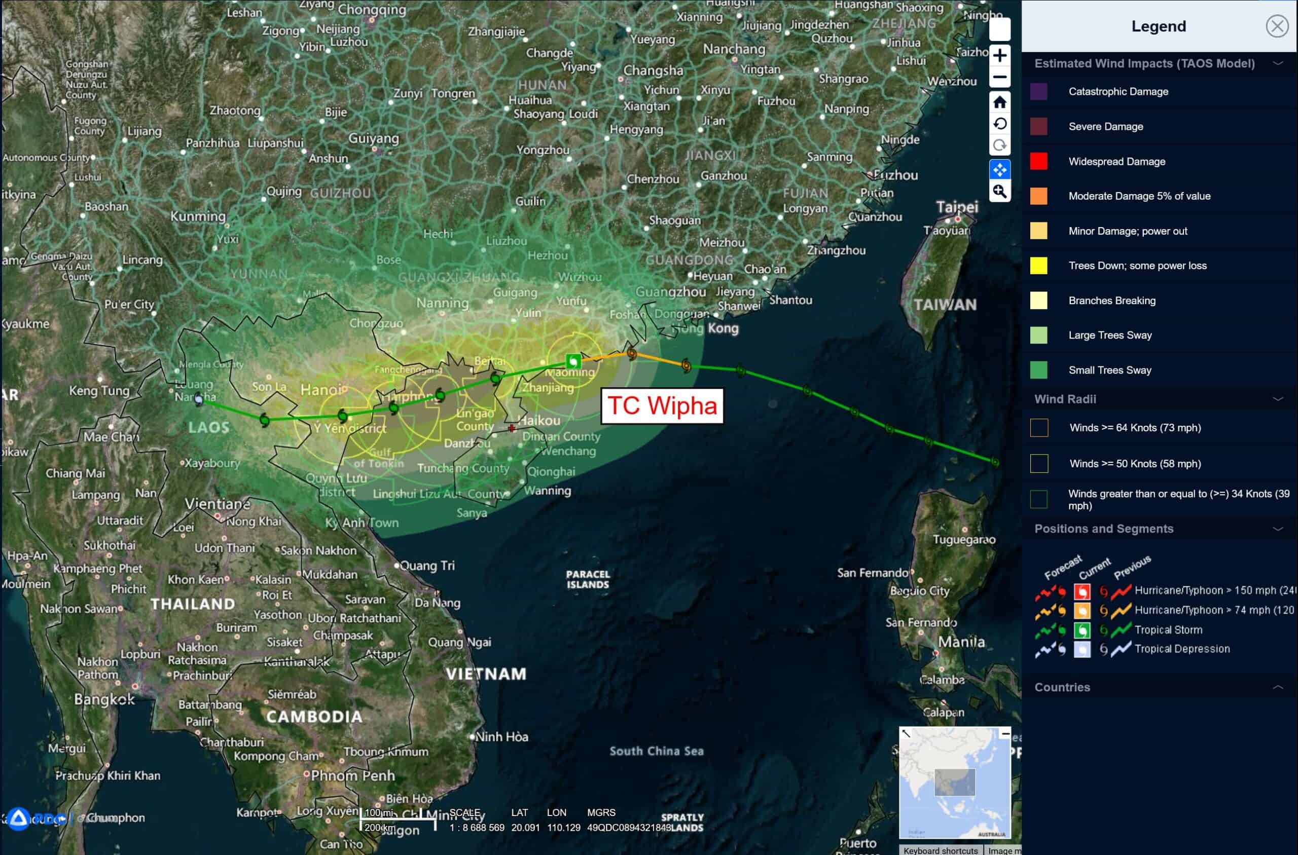
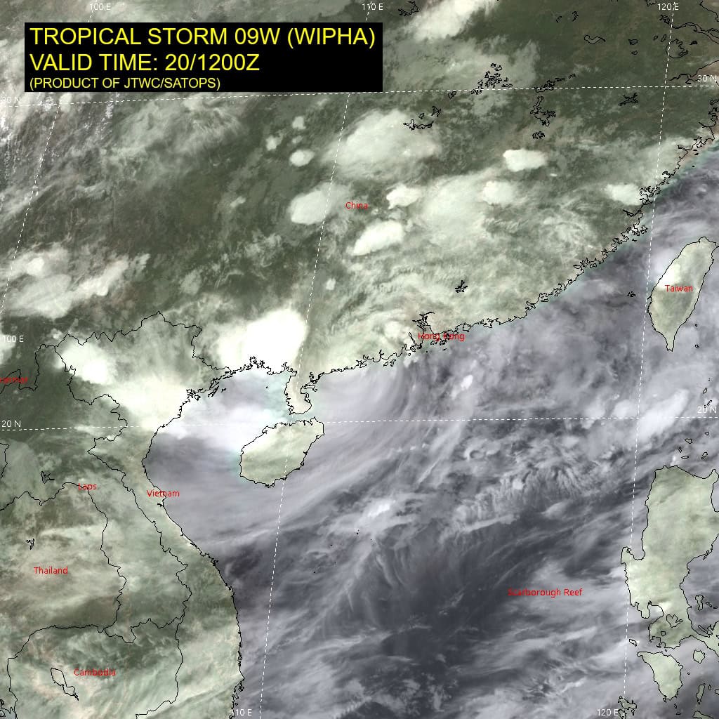
Tropical Cyclone 09W (Wipha)…is located 198 NM east of Hanoi, Vietnam
Northeast Pacific Ocean: There are no Tropical Cyclones
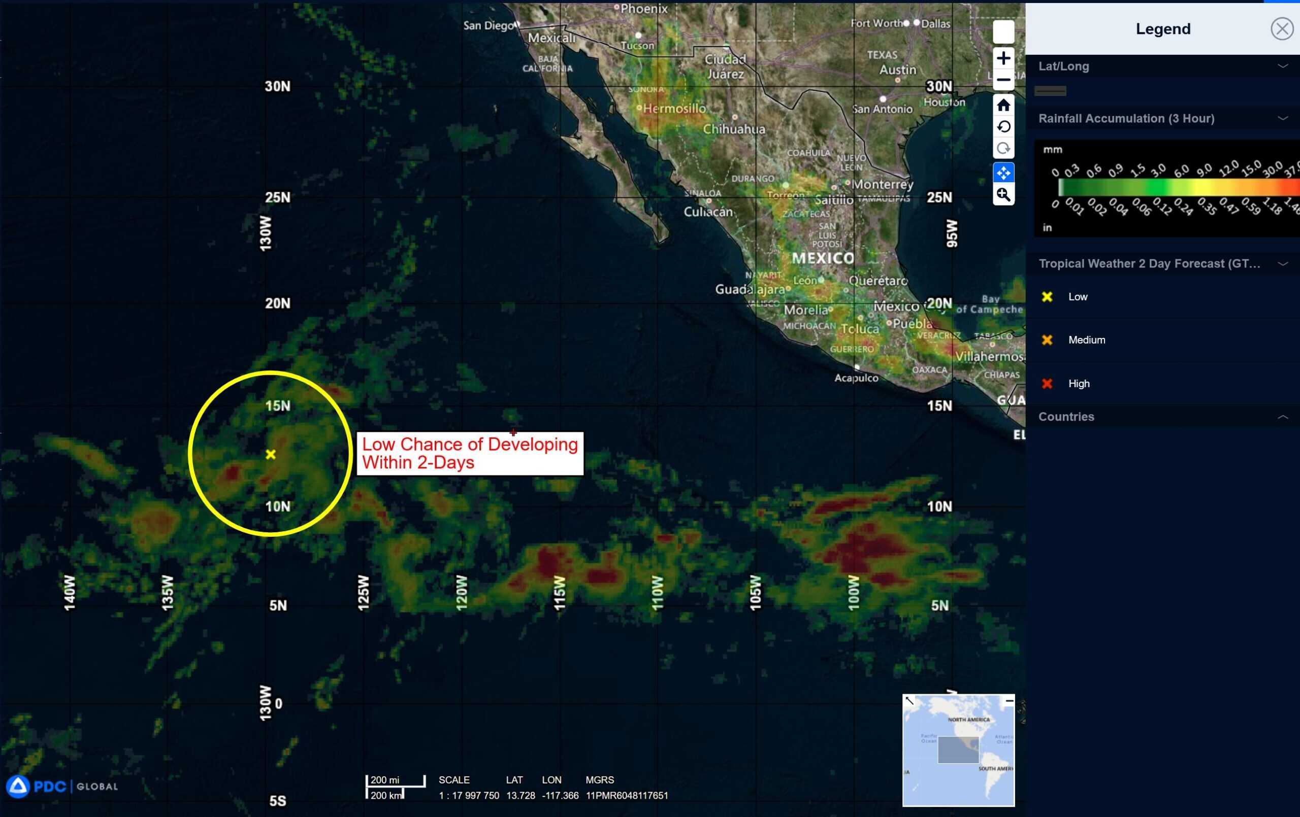
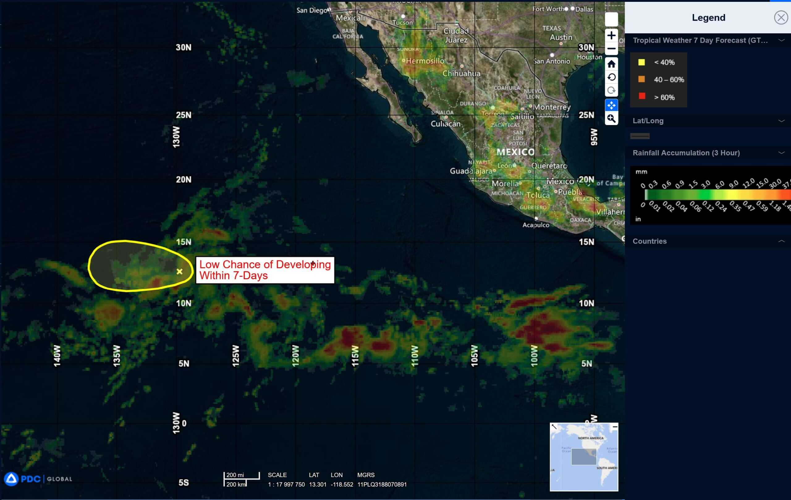
Well West-southwest of the Baja California Peninsula:
>>> A trough of low pressure located well west-southwest of the Baja California peninsula is producing disorganized showers and thunderstorms. Environmental conditions appear only marginally conducive for development during the next day or so as the system moves westward at 10 to 15 mph. By Monday night, conditions are expected to become unfavorable for further development.
* Formation chance through 48 hours…low…10 percent
* Formation chance through 7 days…low…10 percent
Central Pacific Ocean: There are no Tropical Cyclones
Tropical cyclone formation is not expected during the next 7-days.
Western Pacific, Indian Ocean, and adjacent Seas:
Western Pacific
Tropical Cyclone 09W (Wipha)
According to the JTWC warning number 11 sustained winds are 45 knots with gusts to near 55 knots
Animated enhanced infrared (eir) satellite imagery reveals a fully obscured low-level circulation center (llcc) associated with tropical storm 09W (Wipha). Radar imagery, as
well as a 201046z 37 ghz f17 ssmis microwave image suite offer some assistance in estimating the position through extrapolation.
Environmental conditions remain favorable for intensification, in case TS 09W reemerges over water prior to crossing the Leizhou Peninsula. Warm sea surface temperatures (sst), high atmospheric column moisture content and moderate equatorward outflow aloft are
offset only by persistent low to moderate (15-20 knot) northeasterly vertical wind shear (vws).
TS 09W is anticipated to continue on a west-southwestward track, as the synoptic steering environment is in a state of transition. A subtropical ridge (str) to the northeast has weakened and is retrograding, while a secondary str to the northeast is building and is becoming the dominant steering influence. As a result, TS 09W is forecast to track along or just inland of the southern Chinese coastline, eventually moving over the northern portion of the Leizhou Peninsula and transiting over warm waters of the Gulf of Tonkin prior to making landfall over northern Vietnam.
Over the next 12 hours, the system will remain in a favorable environment associated with this part of the South China Sea, however progressive land interaction, particularly during overland vortex placement, will impede structural integrity and limit intensification. Around 12 hours, TS 09W is expected to emerge over the Gulf of Tonkin, where it will encounter high ocean sst, potentially facilitating short-term re-intensification or stabilization of sustained winds.
However, a notable increase in northeasterly vws to over 30 knots by 36 hours is likely to curtail any further intensification. The system is then forecast to make landfall east of Hanoi before 48 hurs, with rapid decay expected due to strong frictional forcing, increased surface roughness, and orographic disruption associated with complex terrain of the northern Vietnam. Complete dissipation of the low-level vortex is anticipated between 72 and 96 hours.
>>> There’s an area of disturbed weather being referred to as Invest 97W, which is located approximately 774 NM south-southeast of Kadena.
Multi-spectral satellite imagery (msi) depicts a poorly organized, broad low level circulation center (llcc) with convective banding over the north eastern peripheries wrapping into the northwest quadrant. An ascat pass reveals 15 to 20 knot winds associated with the convective banding.
Environmental analysis for the area indicates marginally favorable conditions for development with moderate vertical wind shear with (20-25 knots) vertical wind shear offset by warm sea surface temperatures and moderate equatorward outflow aloft.
Global deterministic models are in fair agreement that the area of convection 97W will continue north as it gradually intensifies over the next 48 hours. Ecens and gefs ensemble
guidance agrees on a north-northeastward track. Deterministic model guidance indicates an elevated potential for the system to develop into a monsoon depression, characterized by large scale, cyclonic circulation, with extensive gale-force winds over the periphery and a weak core of light winds.
Maximum sustained surface winds are estimated at 13 to 18 knots.
The potential for the development of a significant tropical cyclone within the next 24 hours is upgraded to medium.
>>> There’s an area of disturbed weather being referred to as Invest 98W, which is located approximately 124 NM east of Fananu
Multi-spectral satellite imagery (msi) depicts a poorly organized low level circulation center
(llcc) with cycling of deep convection south-southeast. An ascat pass with its strongest winds (20-25 knots) isolated to the northwest.
Environmental analysis for the area indicates favorable conditions with low vertical wind shear (10-15 knots) accompanied by warm sea surface temperatures and moderate equatorward outflow aloft.
Global deterministic are in fair agreement that the area of convection 98W will continue north as it gradually intensifies over the next 48 hours. Ensemble guidance agrees on a northward track with gefs being more aggressive on development than ecens.
Maximum sustained surface winds are estimated at 13 to 18 knots.
The potential for the development of a significant tropical cyclone within the next 24 hours is low.