
")
Current Snapshot
For all the latest updates visit: DisasterAWARE
1800x1080e
09s
09S_191200sair

09S_tracks_latest
By PDC’s Senior Weather
Specialist Glenn James

The Pacific Disaster Center’s (PDC Global) Friday, December 19, 2025, Tropical Cyclone Activity Report…for the Pacific Ocean, the Indian Ocean, and adjacent Seas
Current Tropical Cyclones:
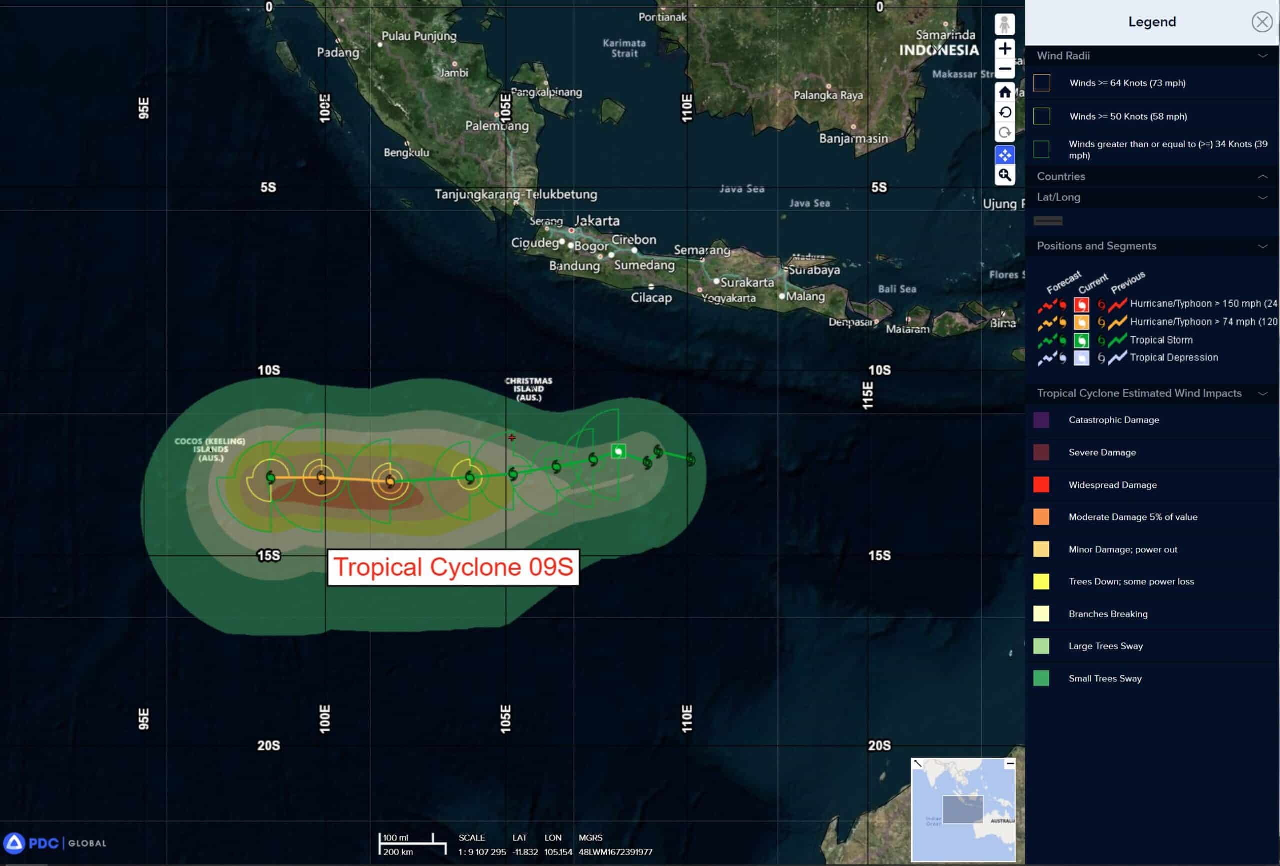
Tropical Cyclone 09S is located approximately 598 NM east of Cocos Islands
Northeast Pacific Ocean: There are no Tropical Cyclones
The last regularly scheduled Tropical Cyclone Activity Report of the 2025 eastern North Pacific Hurricane Season has been issued. Routine issuance of this section of the PDC product will resume on May 15, 2026. During the off-season, Special Tropical Weather Outlooks will be issued as conditions warrant by the NHC.
Central Pacific Ocean: There are no Tropical Cyclones
The 2025 central North Pacific hurricane season has ended. As such, the final routine Tropical Cyclone Activity Report for the 2025 season has been issued. Routine issuance of this section of the PDC product will resume on June 1, 2026. During the off-season, Special Tropical Weather Outlooks will be issued as conditions warrant by the CPHC.
Western Pacific, Indian Ocean, and adjacent Seas:
South Indian Ocean
Tropical Cyclone 09S
According to the JTWC warning number 6, sustained winds are 40 knots with 50 knot gusts
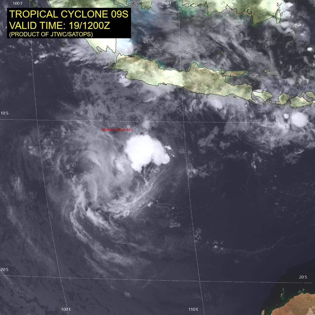
Animated enhanced infrared (eir) satellite and animated shortwave infrared satellite imagery depicts a compact and now fully obscured
low level circulation center (llcc). Over the past 12 hours, the llcc has moved west, tucked under the edge of moderate convection which developed earlier in the day, then performed a clockwise loop, emerging into the clear around 1000z before once more moving under the currently developing convection. the recent convective burst is primarily focused on the western flank of the circulation, where the previous convective burst have developed, and exhibits a sharp eastern edge indicative of the presence of moderate easterly shear.
Environmental conditions remain marginal, with moderate easterly shear, weak westward outflow aloft and warm ssts.
Tropical cyclone 09S is currently meandering in a clockwise loop, caught in a relatively weak steering pattern with ridging in the lower-levels both to the north and south. However, over the next 12 to 24 hours, the ridge to the north is forecast to weaken while ridging to the south builds, which will allow TC 09A to begin tracking westward. The system then tracks westward through the remainder of the forecast period, along the northern side of a subtropical ridge (str) complex to the south.
Track speeds will be relatively slow, due to development of a trof or area of low heights aloft which stays west of Australia through the forecast period, inducing a slight weakness in the ridge south of TC 09S, keeping the steering gradient weaker than it might otherwise be. Some models, including the gfs and hwrf, show TC 09S being caught by this trof and moving poleward after 48 hours, while the ecmwf, hafs-a and most of the ensembles keep the system moving west and not being caught by the trof.
In terms of intensity, shear is already decreasing, down about 10 knots from yesterday and the atmosphere is moistening up. But the vortex remains highly tilted and will take some time to align. Intensity is thus expected to remain flat, or even briefly dip down to 30 knots, over the next 24 hours. By 36 hours, the vortex should be aligned, and shear will be low, allowing for the system to begin intensifying. A peak of around 70 knots is expected around 84 hours before shear begins to
increase and dry air moves in from the northwest, marking the beginning of the weakening phase.