
")
Current Snapshot
For all the latest updates visit: DisasterAWARE
1800×1080

grant
09S_231200sair

himawari9_ir_09S_202512231450_lat-12.2-lon99.1
09S_tracks_latest
By PDC’s Senior Weather
Specialist Glenn James

The Pacific Disaster Center’s (PDC Global) Tuesday, December 23, 2025, Tropical Cyclone Activity Report…for the Pacific Ocean, the Indian Ocean, and adjacent Seas
Current Tropical Cyclones:
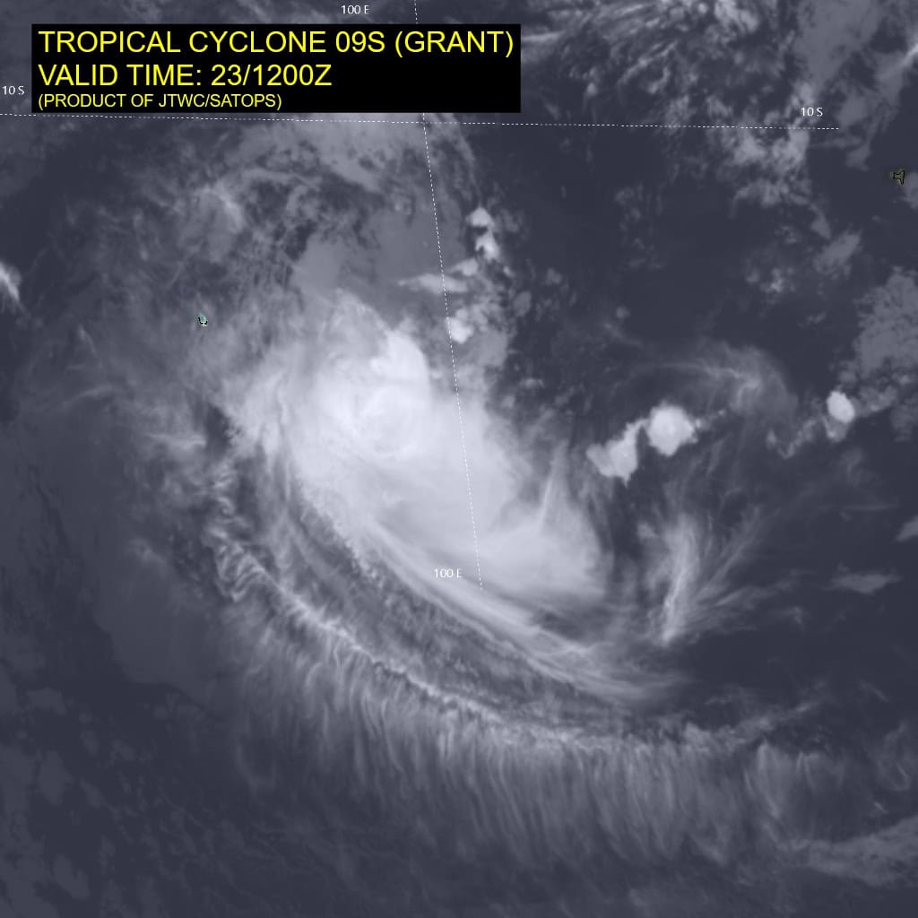
Tropical Cyclone 09S (Grant) is located approximately 76 NM east of the Cocos Islands
Northeast Pacific Ocean: There are no Tropical Cyclones
The last regularly scheduled Tropical Cyclone Activity Report of the 2025 eastern North Pacific Hurricane Season has been issued. Routine issuance of this section of the PDC product will resume on May 15, 2026. During the off-season, Special Tropical Weather Outlooks will be issued as conditions warrant by the NHC.
Central Pacific Ocean: There are no Tropical Cyclones
The 2025 central North Pacific hurricane season has ended. As such, the final routine Tropical Cyclone Activity Report for the 2025 season has been issued. Routine issuance of this section of the PDC product will resume on June 1, 2026. During the off-season, Special Tropical Weather Outlooks will be issued as conditions warrant by the CPHC.
Western Pacific, Indian Ocean, and adjacent Seas:
South Indian Ocean
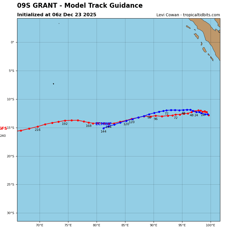
Tropical Cyclone 09S (Grant)
According to the JTWC warning number 14, sustained winds are 40 knots with 50 knot gusts
Animated enhanced infrared (eir) satellite imagery depicts a very compact yet ill-defined tropical cyclone (tc) which continues to be negatively affected by the environment. Persistent northeasterly shear, currently estimated by cimss to be running at about 16 knots, has adversely impacted the system over the past 6 to 12 hours.
Earlier in the day, convection was able to develop and remain over the low-level circulation center (llcc), with a nascent microwave eye feature developing in microwave imagery from approximately 0600z.
However, since that time, the convection has rapidly dissipated and become displaced to the south, leaving behind an llcc obscured by mid-level clouds, which while exhibiting rotation, are not formed into a well-structured rotation. A 231120z gmi 37ghz microwave image indicated that while the outer bands are fairly well formed, the inner core structure is disorganized and lacks a clearly defined center.
Environmental conditions are marginal, with moderate to high northeasterly shear, weak poleward outflow aloft, warm ssts and dry mid-level to the north of the system.
Tropical cyclone 09S (Grant) is forecast to slowly track northwestward over the next 12 to 24 hours, along the low- to mid-level gradient along the northeastern periphery of the str centered far to the southwest. As the system strengthens and deepens vertically, it will come under the influence of the a building str off the northwest coast of Australia, and begin a gradual turn onto a more west-southwestward trajectory after 48 hours. This ridge is forecast to move towards the southwest along with TC 09S, keeping TC 09S on the northwest periphery of the ridge, and thus, firmly on a west-southwestward track, through the end of the
forecast period.
In terms of intensity, the system will struggle to consolidate in the face of the persistent shear in the near-term. In addition, its compact size will render it particularly susceptible to small changes in the environment, and there is a possibility that it will weaken slightly in the next 6 to 12 hours. However, all available guidance indicates the environment will improve after 12 hours, with gradually increasing moisture, improved upper-level outflow and decreasing shear.
Assuming the system can maintain its structure for another 12 hours, it is poised to intensify in the mid-range forecast, up to a peak of approximately 65 knots by 72 hours. After that, it is expected to suffer from another penetration of dry air into the core of the system and another round of increased shear as a trof passes by to the south. These conditions are not expected to persist however, and while the system will weaken a bit after 72 hours, it should be able to survive and maintain intensity after 96 hours.