
")
Current Snapshot
For all the latest updates visit: DisasterAWARE
atlantic
atlantic222
goes19_ir_08L_202509301552_lat32.5-lon-69.8
301444_earliest_reasonable_toa_34hum
08L_tracks_latest
goes19_ir_09L_202509301537_lat29.0-lon-76.9
301453_earliest_reasonable_toa_34im
09L_tracks_latest
By PDC’s Senior Weather
Specialist Glenn James

The Pacific Disaster Center’s (PDC Global) Tuesday, September 30, 2025, Tropical Cyclone Activity Report…for the Atlantic Ocean, the Caribbean Sea, and the Gulf of America
Current Tropical Cyclones:
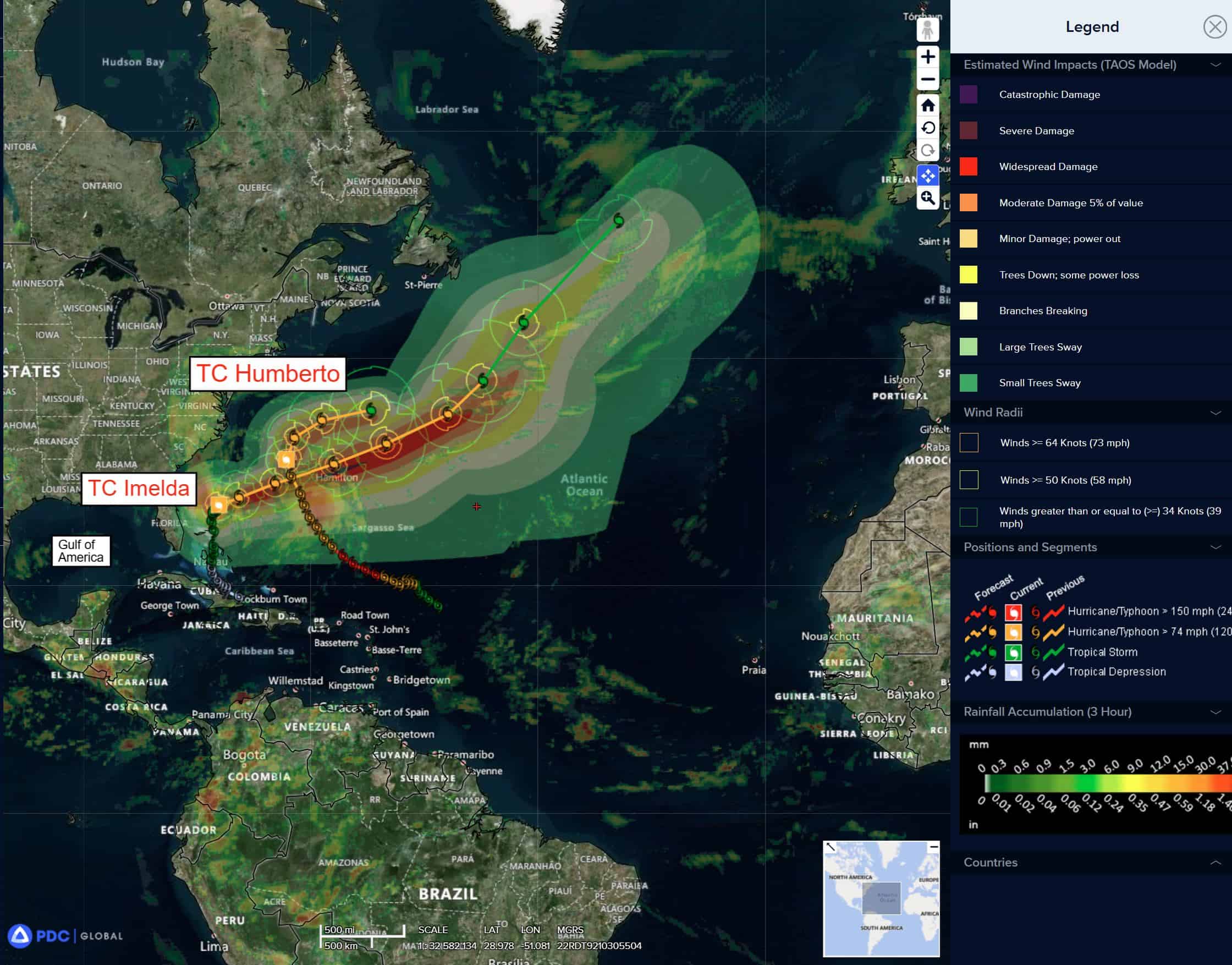
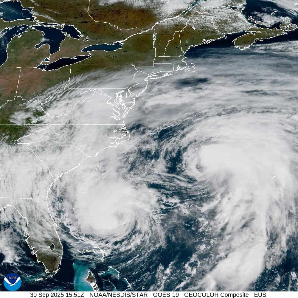
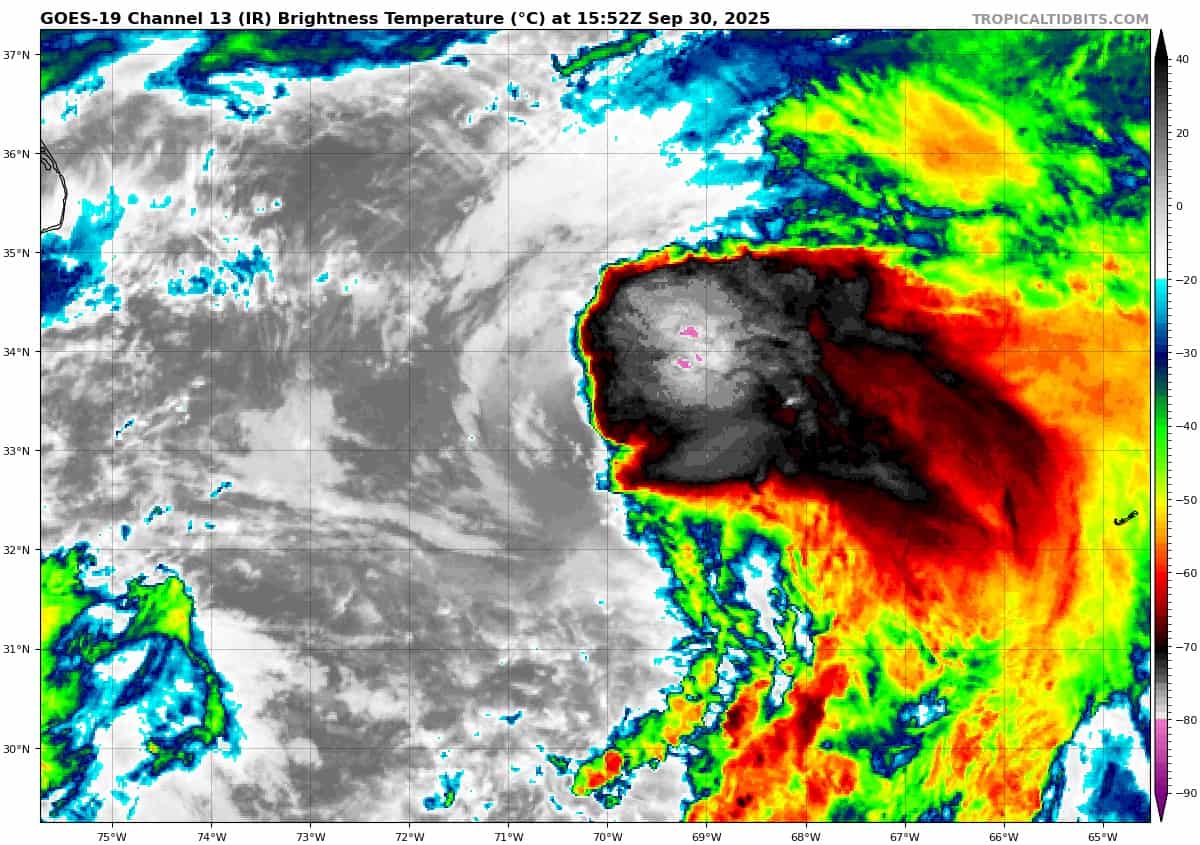
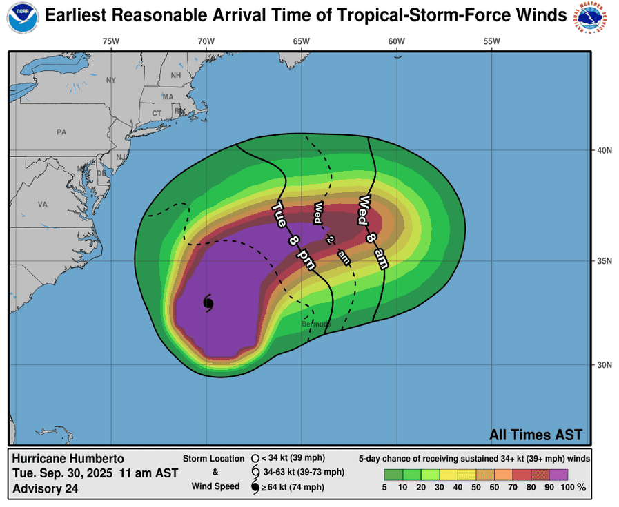
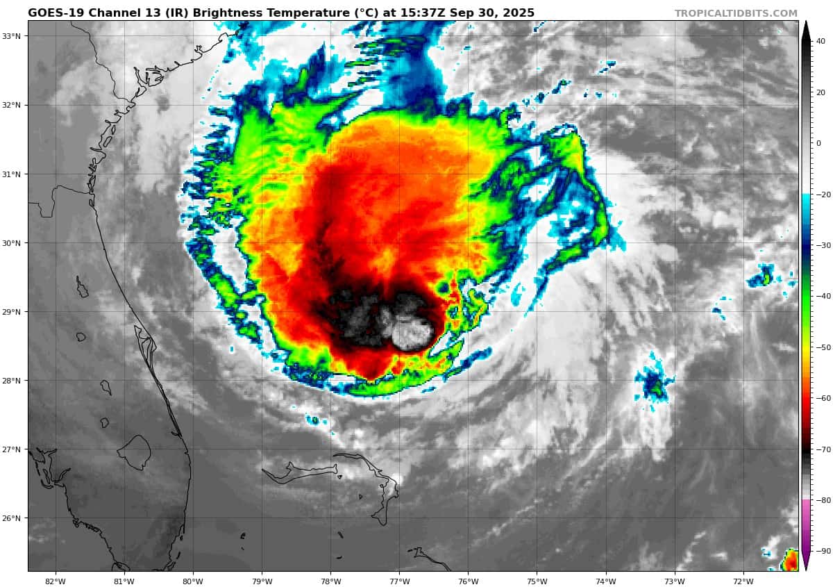
Tropical Cyclone 08L (Humberto)…is located about 275 miles northwest of Bermuda
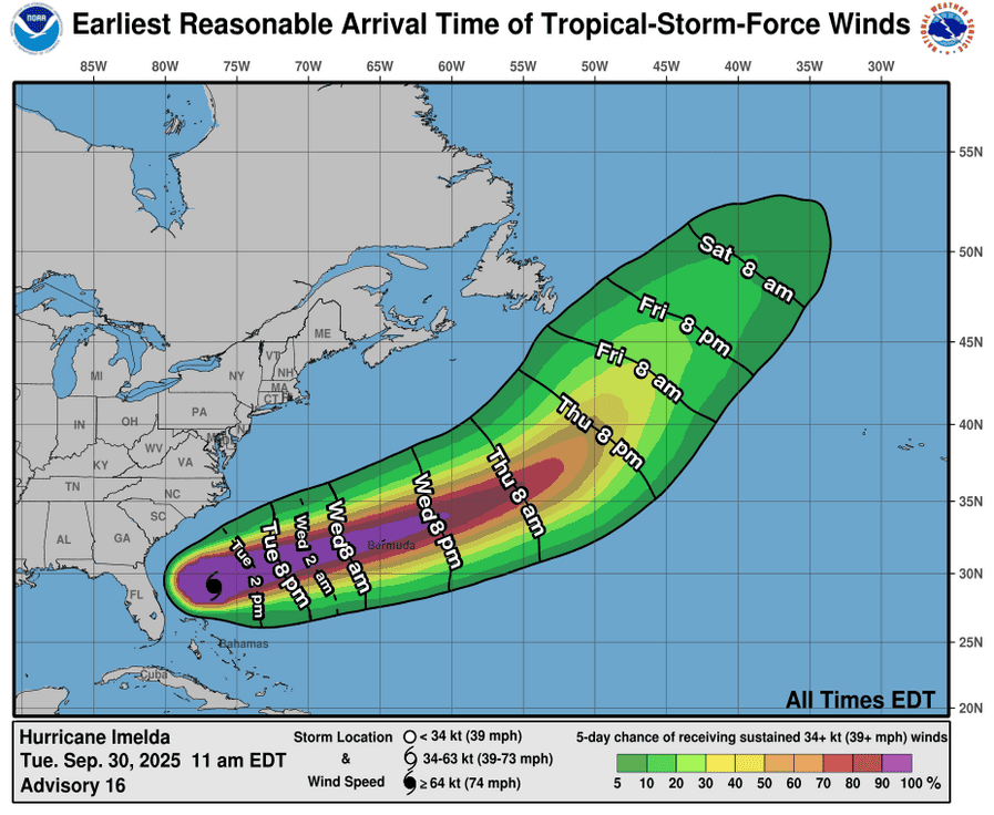
Tropical Cyclone 09L (Imelda)…is located about 735 miles west-southwest of Bermuda
Atlantic Ocean:
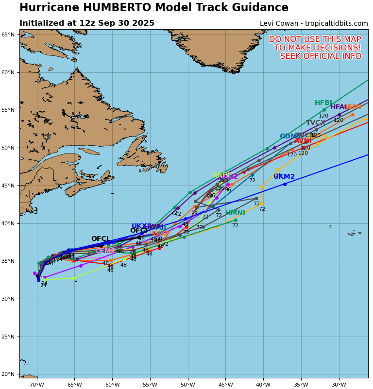
Tropical Cyclone 08L (Humberto)
HUMBERTO LIKELY TO MERGE WITH A FRONTAL BOUNDARY ON WEDNESDAY…DANGEROUS SURF AND RIP CURRENTS TO CONTINUE ACROSS THE WESTERN ATLANTIC COASTLINE THROUGH THE WEEK
According to the NHC advisory number 26
Humberto is moving toward the east-northeast near 10 mph (17 km/h) and this motion is expected to continue until the system merges with a developing frontal boundary.
Maximum sustained winds are near 80 mph (130 km/h) with higher gusts. Continued weakening is forecast and Humberto is expected to merge with a frontal boundary on Wednesday.
Hurricane-force winds extend outward up to 35 miles (55 km) from the center and tropical-storm-force winds extend outward up to 265 miles (425 km). The estimated minimum central pressure is 979 mb (28.91 inches).
HAZARDS AFFECTING LAND SURF:
SURF: Swells from Humberto are likely to cause dangerous surf and life-threatening rip current conditions, affecting beaches of the northern Caribbean, Bahamas, Bermuda, and much of the east coast of the United States over the next several days.
WIND: Gusty winds are possible over Bermuda within outer rainbands today into Wednesday.
RAINFALL: Any distant rainbands associated with Humberto are expected to bring an additional 1 inch (25 mm) or less of rainfall to Bermuda tonight.
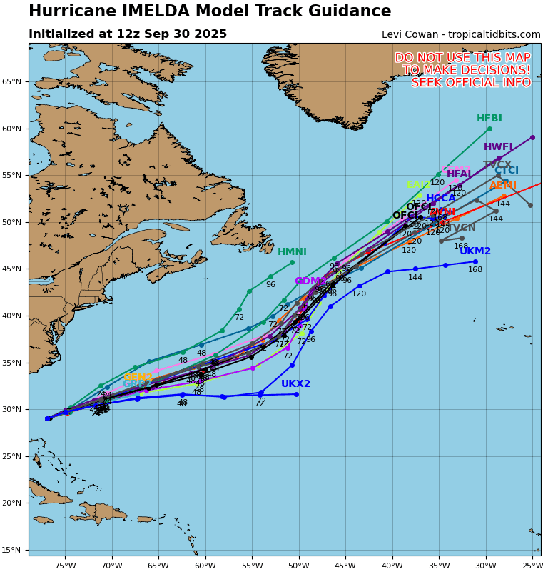
Tropical Cyclone 09L (Imelda)
IMELDA FORECAST TO ACCELERATE TOWARD BERMUDA…EXPECTED TO BRING HURRICANE CONDITIONS TO THE ISLAND WEDNESDAY EVENING
According to the NHC advisory number 18
Imelda is moving toward the east-northeast near 15 mph (24 km/h). A much faster east-northeast to northeast motion is expected over the next couple of days. On the forecast track, the core of the hurricane will be near Bermuda Wednesday evening.
Maximum sustained winds are near 85 mph (140 km/h) with higher gusts. Some additional strengthening is forecast during the next day or so. Imelda is then expected to become an extratropical low in a couple of days.
Hurricane-force winds extend outward up to 60 miles (95 km) from the center and tropical-storm-force winds extend outward up to 160 miles (260 km). The estimated minimum central pressure based on data from the Air Force Hurricane Hunters is 977 mb (28.85 inches).
HAZARDS AFFECTING LAND
WIND: Hurricane conditions are expected over Bermuda by Wednesday evening, with tropical storm conditions possible by Wednesday afternoon.
RAINFALL: Across Bermuda, 2 to 4 inches (50 to 100 mm) of rainfall are expected from Wednesday into Thursday, which could lead to flash flooding.
STORM SURGE: In Bermuda, a dangerous storm surge is expected to produce coastal flooding in areas of onshore winds. The surge will be accompanied by large and damaging waves.
SURF: Swells generated by Hurricane Imelda and Hurricane Humberto are affecting the Bahamas, Bermuda, and much of the U.S. east coast. These swells are likely to cause life-threatening surf and rip current conditions.
Caribbean Sea: There are no active tropical cyclones
Tropical cyclone formation is not expected during the next 7-days.
Gulf of America: There are no active tropical cyclones
Tropical cyclone formation is not expected during the next 7-days.