Tropical cyclone formation is not expected during the next 7 days.
Western Pacific, Indian Ocean, and adjacent Seas:

")
By PDC’s Senior Weather
Specialist Glenn James

The Pacific Disaster Center’s (PDC Global) Monday, August 4, 2025, Tropical Cyclone Activity Report…for the Pacific Ocean, the Indian Ocean, and adjacent Seas
Current Tropical Cyclones:
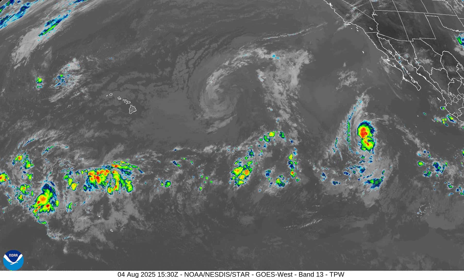
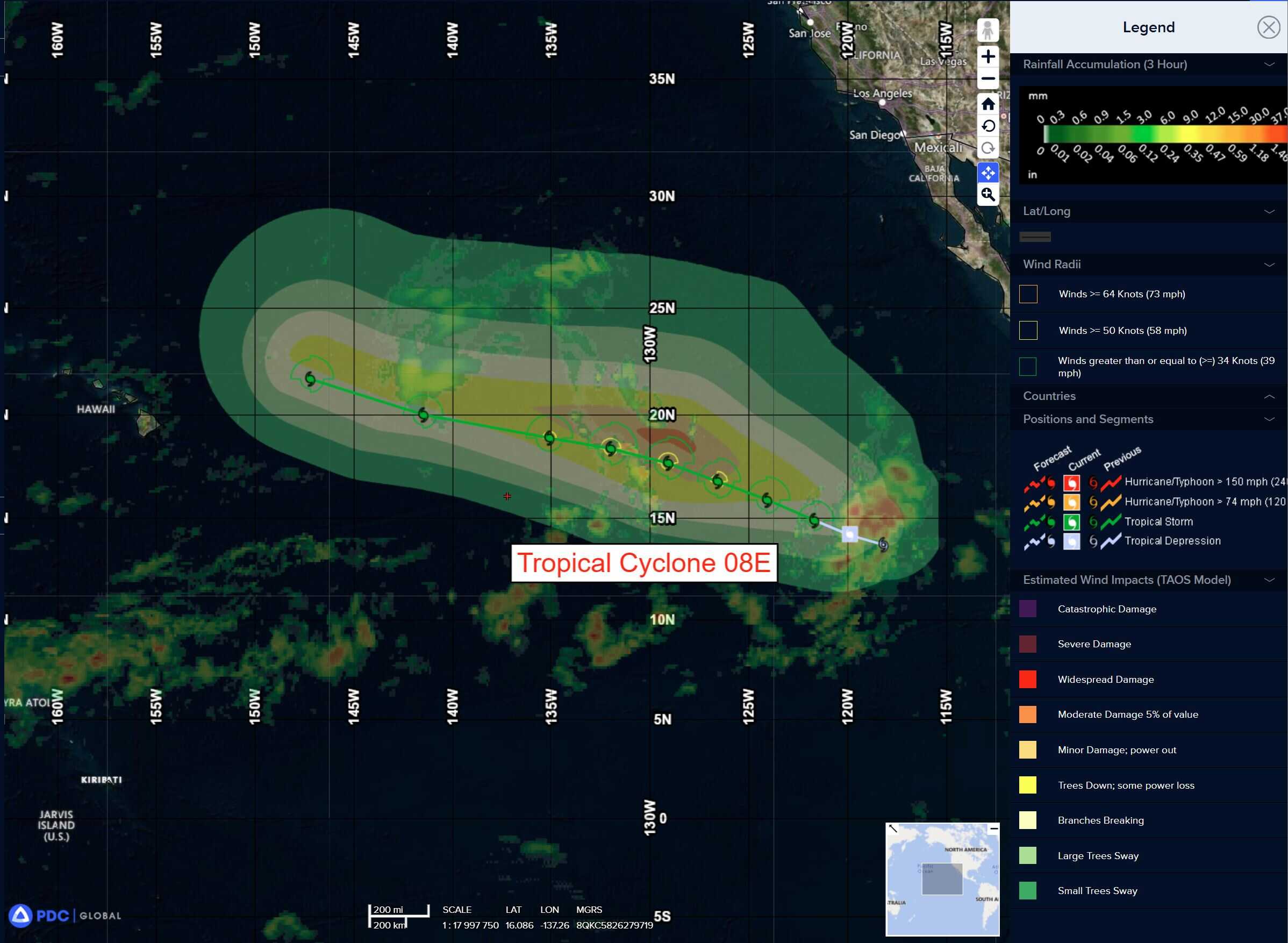
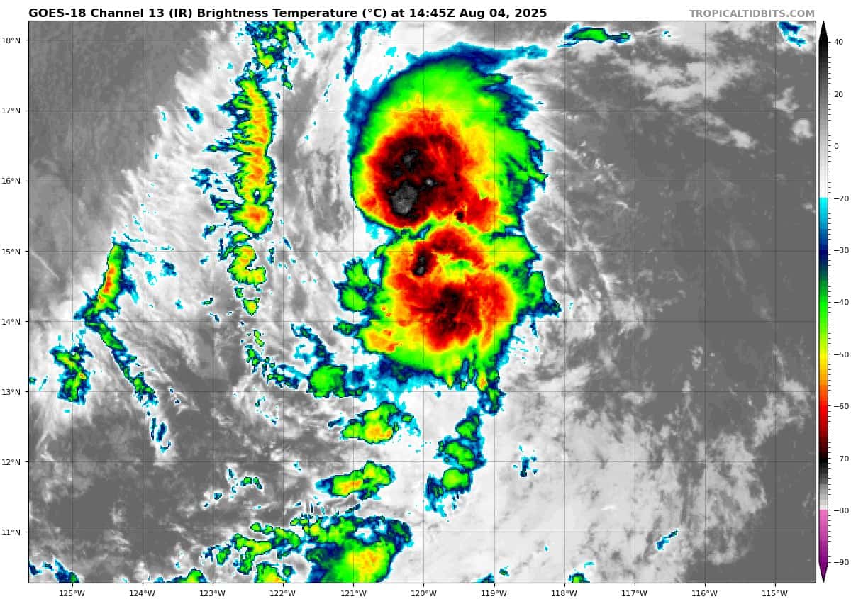
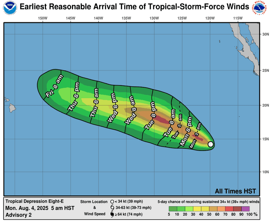
Tropical Cyclone 08E (Henriette)…is located approximately 940 NM west-southwest of the southern tip of Baja California
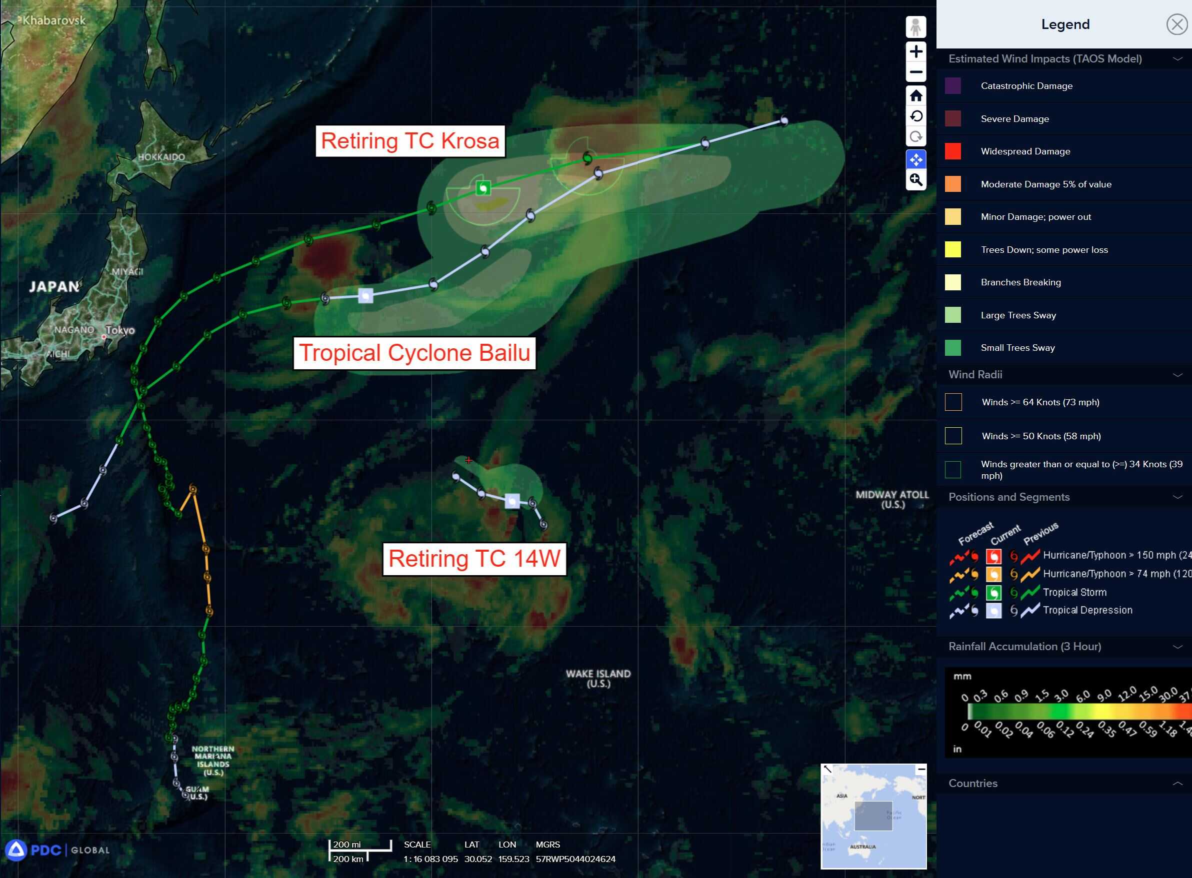
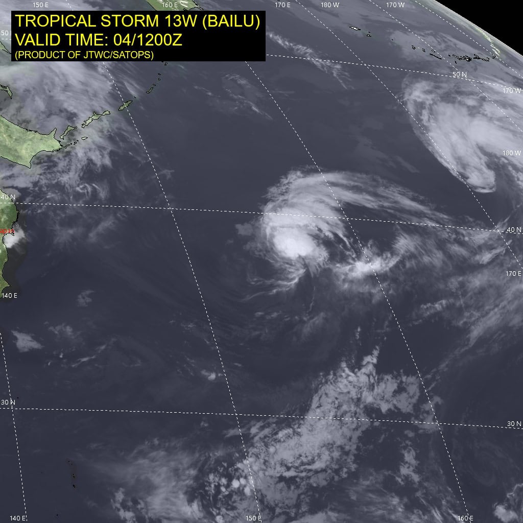
Tropical Cyclone 13W (Bailu)…is located approximately 755 NM east of Misawa, Japan
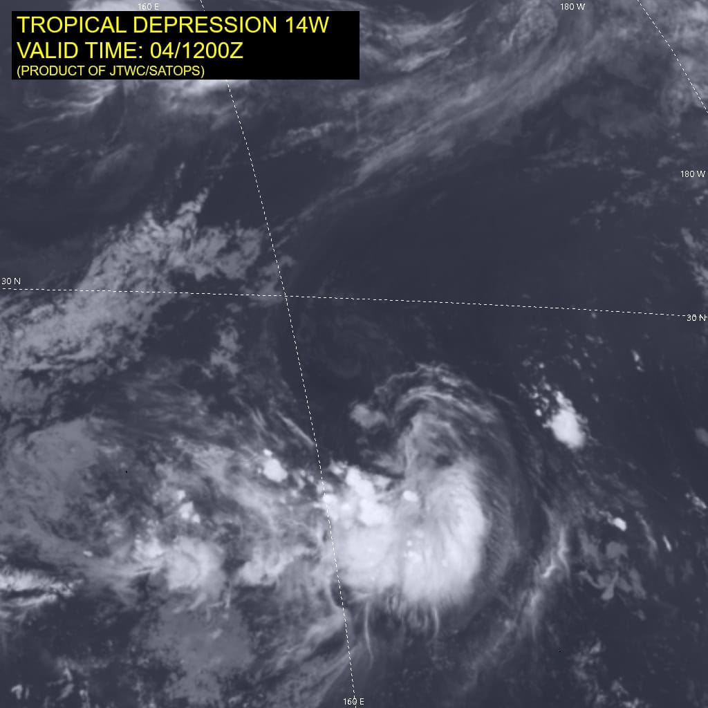
Tropical Cyclone 14W…is located approximately 588 NM north-northwest of Wake Island – Final Warning
Northeast Pacific Ocean:
Tropical Cyclone 08E (Henriette)
HENRIETTE STRENGTHENS SOME FAR TO THE EAST-SOUTHEAST OF HAWAII
According to the NHC advisory number 4
Henriette is moving toward the west-northwest near 15 mph (24 km/h). This general motion is expected to continue during the next few days. Maximum sustained winds are near 50 mph (85 km/h) with higher gusts. Some additional strengthening is forecast during the next day or so, followed by gradual weakening. Tropical-storm-force winds extend outward up to 80 miles (130 km) from the center.
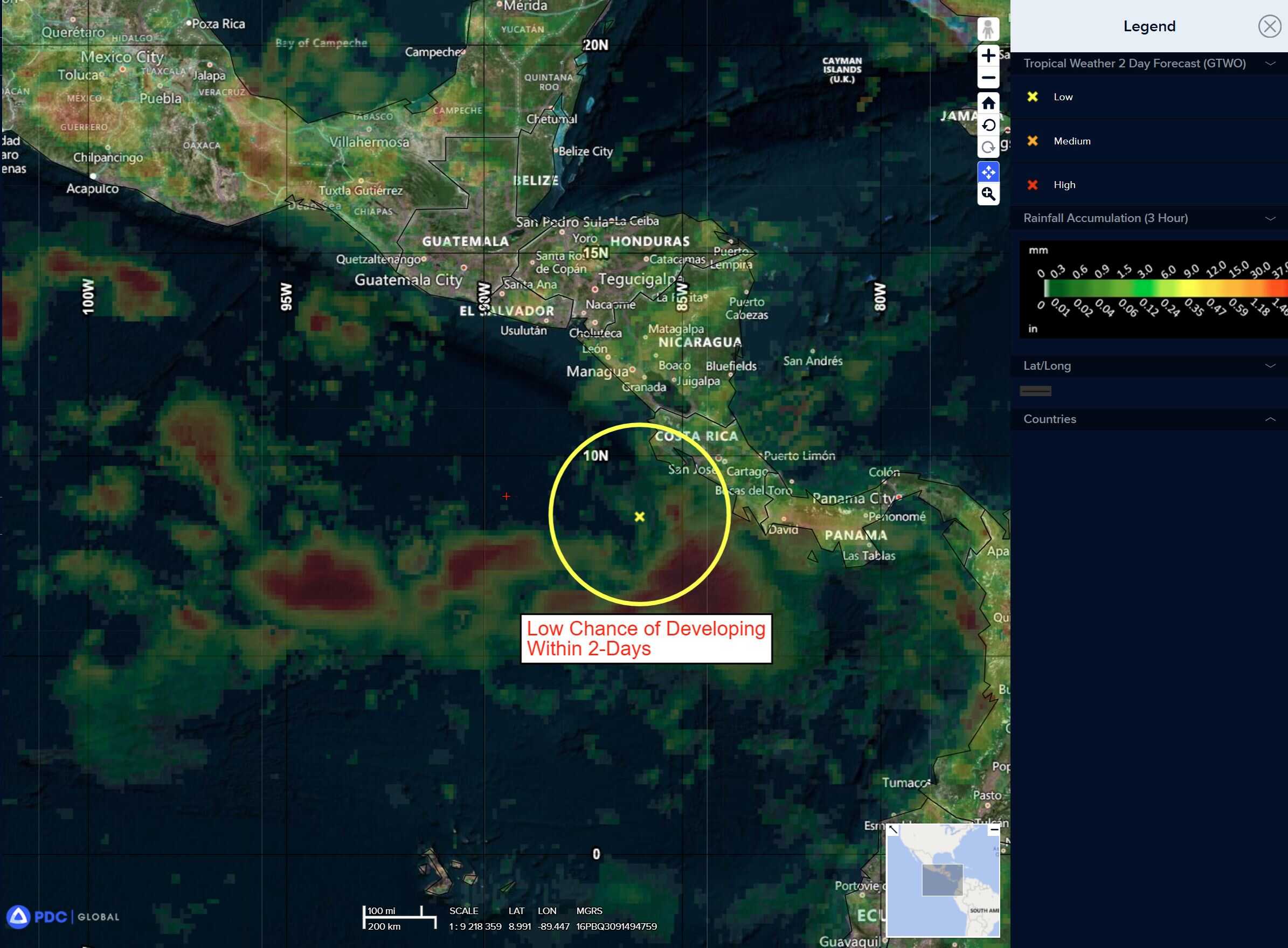
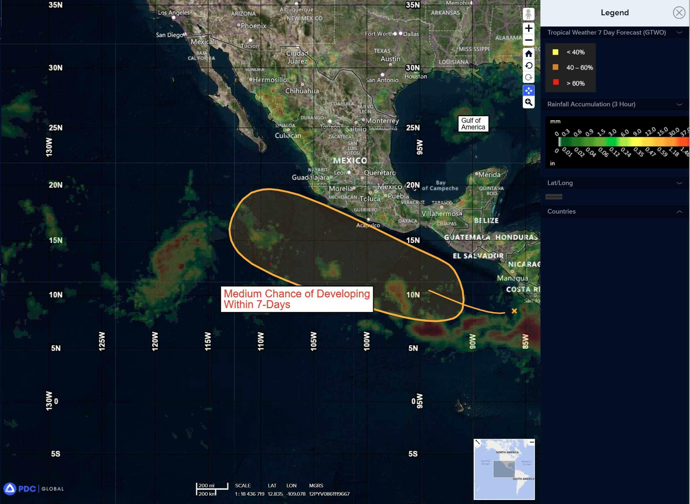
South of Southern Mexico:
>>> An area of low pressure just offshore of the coast of Central America is producing a large area of disorganized showers and thunderstorms. Environmental conditions appear conducive for development of this system, and a tropical depression is likely to form later this week while the system moves west-northwestward around 15 mph.
* Formation chance through 48 hours…low…30 percent
* Formation chance through 7 days…high…80 percent
Central Pacific Ocean: There are no Tropical Cyclones
Tropical cyclone formation is not expected during the next 7 days.
Western Pacific, Indian Ocean, and adjacent Seas:
Western Pacific
Tropical Cyclone 13W (Bailu)
According to the JTWC warning number 13 sustained winds are 30 knots with gusts to near 40 knots
Animated proxy visible (proxyvis) satellite imagery depicts a fully
decoupled system, with a well-defined low level circulation center (llcc) displaced to the west of a mid- and upper-level rotation pushed off to the east. Animated water vapor imagery depicts upper-level cirrus diving southward to the west of the llcc, then turning sharply northeastward in the immediate vicinity of the center, supporting the cimss atmospheric motion vector (amv) analysis as well as the ecmwf model depiction.
The upper-level winds are fairly strong but area in phase with the storm motion, with deep-layer shear estimated at about 10 knots. Meanwhile, the cira advected layer precipitable water analysis depicts a deep wedge of dry air along the western flank of the system, helping keep convective activity to a minimum. A 041117z ascat-c pass reveals an elongated low-level structure, with a secondary circulation developing to the east of the primary llcc. 25-30 knot winds are present across most of the southern hemisphere of the circulation with lighter winds on the northern flank.
Environmental conditions are increasingly unfavorable cool ssts and dry air intrusion offsetting strong poleward outflow and low shear.
Tropical depression 13W has traveled almost due eastward over the last 6 hours or so, along the northeastern flank of a retrograding str now positioned southeast of Honshu. The system will imminently begin slowing down as it moves by to the north of a col-region between the str south of Honshu and a second str building in from near the dateline. As TD 13W runs into the northwestern flank of this eastern str, around 24 hours, it will turn northeastward and continue to slow down a bit
as it makes this first encounter.
As the ridge continues to slide off to the southwest, the steering gradient strengthens to the southern flank of TD 13W, and the system will accelerate off towards the northeast after 36 hours, continuing through the end of the forecast period.
The 200mb trof that is currently positioned just west of TD 13W is forecast to continue tracking eastward at about the same speed as TD 13W for the next 24 hours. This will keep it in a generally favorable position and continue providing a source of divergent poleward outflow, allowing TD 13W to hold onto 30 knot intensity for just a bit longer.
By 24 hours however, the trof moves out ahead of TD 13W, ushering in convergent flow aloft and even more dry air in the mid-levels, and TD 13W will weaken further during this time frame. The system begins extratropical transition (ett) around 36 hours and should complete transition around 60 hours or slightly earlier, though the forecast is extended to 72 hours due to forecast point constraints.
Tropical Cyclone 14W – Final Warning
According to the JTWC warning number 3 sustained winds are 25 knots with gusts to near 35 knots
Animated proxy visible (proxyvis) satellite imagery depicts a compact and ragged low level circulation center (llcc) completely devoid of convective activity, smothered under a deep layer of dry air. A 041024z ascat-b pass reveals a very small cusp feature, with no clear earth-relative westerlies on the southern side of the circulation and a very small patch of 25 knot winds along the gradient on the eastern flank.
Environmental conditions are highly unfavorable, with moderate to high northeasterly shear, very dry air aloft and a lack of any significant outflow. TD 14W is forecast to track general west-northwestward through the short duration of the forecast while continuing to weaken below warning criteria within the next 12 hours.
Model guidance is split on the direction TD 14W will take over the next 24 hours, with the GFS and GEFS showing a turn to the southwest while the ECMWF and ECENS track northwest.
>>> There’s an area of disturbed weather being referred to as Invest 97W, which is located approximately 545 NM northwest of Wake Island
Animated multi-spectral satellite imagery (msi) depicts a disorganized low level circulation center (llcc) with persistent convection and formative banding wrapping around the llcc to the east.
Environmental analysis reveals a marginally favorable environment for development with low to moderate vertical wind shear (vws) of 15-20 knots, good equatorward upper-level outflow, and warm sea surface temperatures.
Deterministic and ensembles models are in good agreement showing a northward track and marginal development over the
next 24 hours.
Maximum sustained surface winds are estimated at 10 to 15 knots.
The potential for the development of a significant tropical cyclone within the next 24 hours is low.
South Indian Ocean
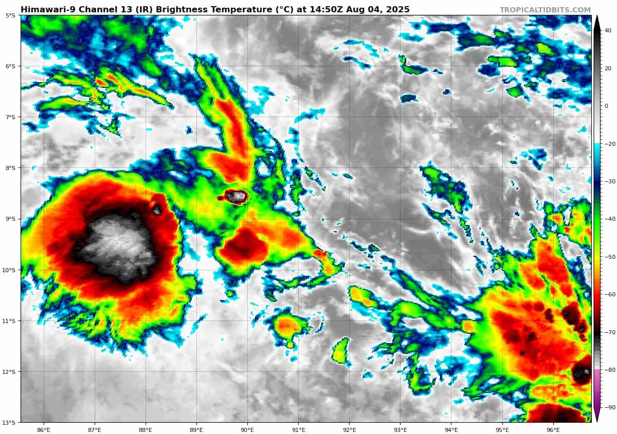
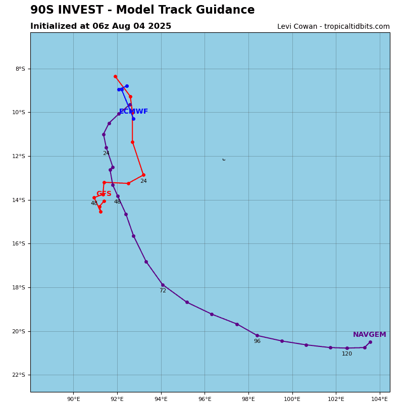
>>> There’s an area of disturbed weather being referred to as Invest 90S, which is located approximately 315 NM west-northwest of Cocos Islands
Animated multi-spectral satellite imagery (msi) and a 041230z f16 ssmis 91 ghz microwave image depict a weakly-defined, fully-exposed low level circulation center (llcc) with flaring convection displaced far to the west and southeast. A partial
041514z metop-b ascat pass indicates 10-15 knots along the eastern and western periphery of the llcc with 20 knots to the south.
Environmental analysis reveals an unfavorable environment for development with warm sea surface temperatures (sst) offset by high easterly vertical wind shear (vws) of 25-30 knots and weak upper-level outflow.
Deterministic and ensemble models are in slight agreement with the bulk of the conciseness revealing an elongated system that struggles to consolidate.
Maximum sustained surface winds are estimated at 20 to 25 knots.
The potential for the development of a significant tropical cyclone within the next 24 hours is downgraded to low.