
")
Current Snapshot
For all the latest updates visit: DisasterAWARE

1800×1080
bakung
07S_150600sair
07S_tracks_latest
08p
08P_151200sair
08P_tracks_latest
93s
himawari9_ir_93S_202512151430_lat-12.5-lon114.1

93S_tracks_latest
By PDC’s Senior Weather
Specialist Glenn James

The Pacific Disaster Center’s (PDC Global) Monday, December 15, 2025, Tropical Cyclone Activity Report…for the Pacific Ocean, the Indian Ocean, and adjacent Seas
Current Tropical Cyclones:
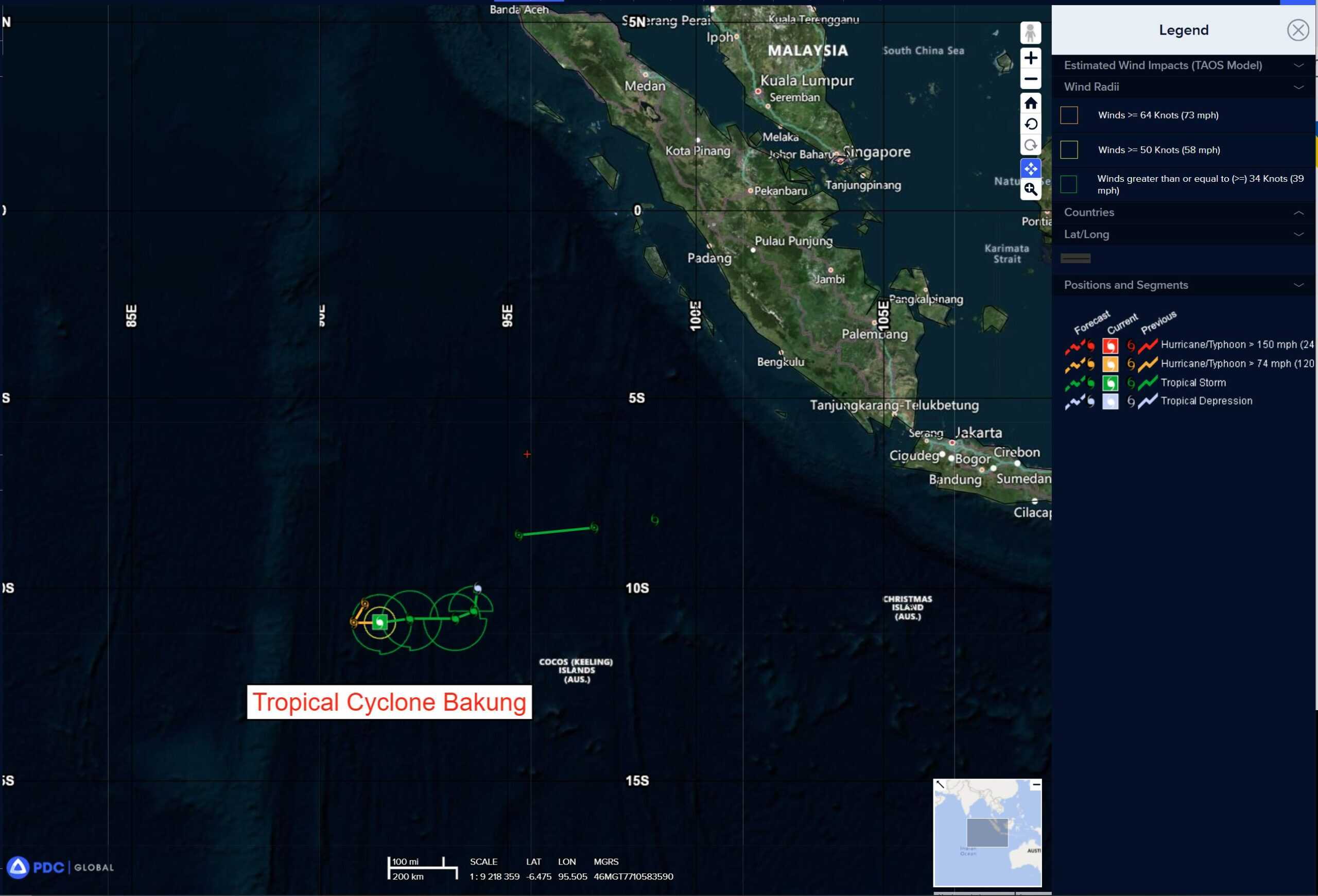
Tropical Cyclone 07S (Bakung) is located approximately 321 NM west-northwest of the Cocos Islands
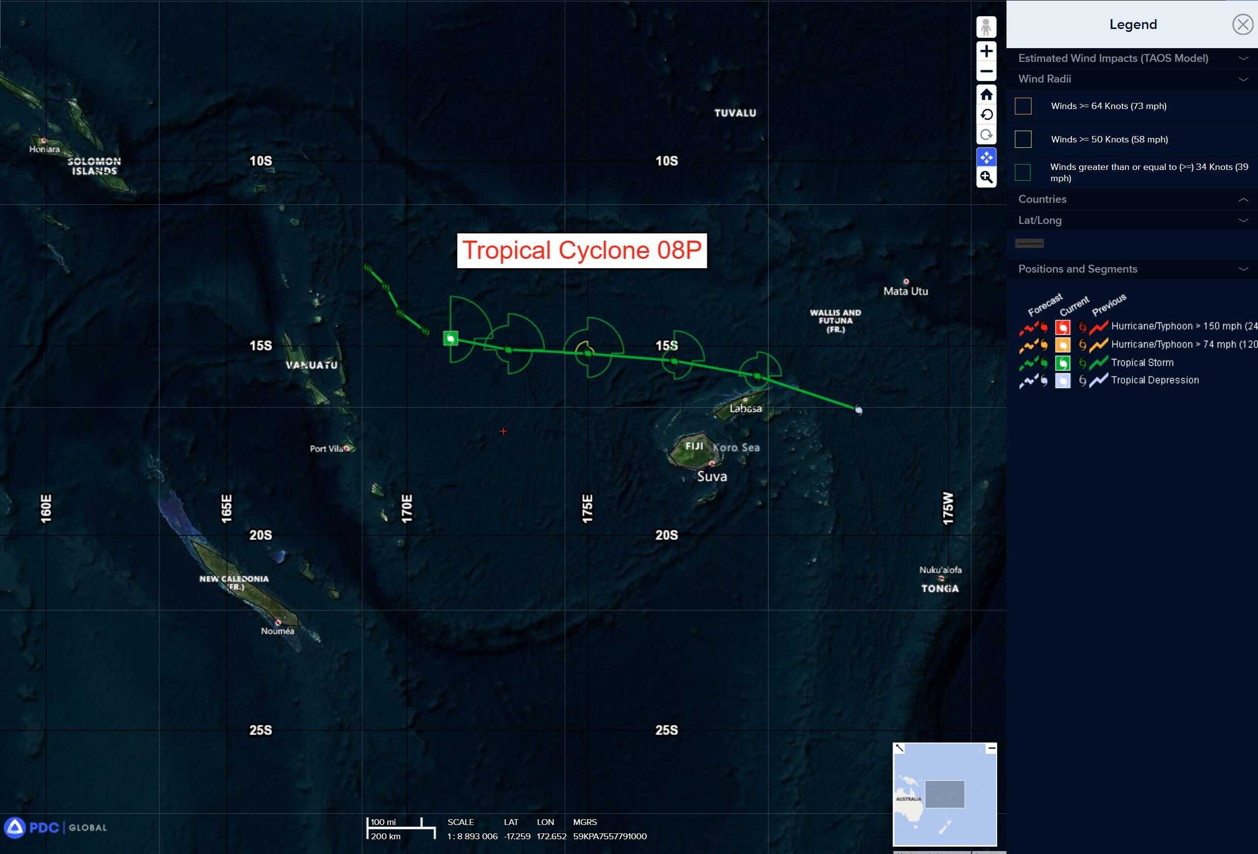
Tropical Cyclone 08P is located approximately 241 NM northeast of Port Vila, Vanuatu
Northeast Pacific Ocean: There are no Tropical Cyclones
The last regularly scheduled Tropical Cyclone Activity Report of the 2025 eastern North Pacific Hurricane Season has been issued. Routine issuance of this section of the PDC product will resume on May 15, 2026. During the off-season, Special Tropical Weather Outlooks will be issued as conditions warrant by the NHC.
Central Pacific Ocean: There are no Tropical Cyclones
The 2025 central North Pacific hurricane season has ended. As such, the final routine Tropical Cyclone Activity Report for the 2025 season has been issued. Routine issuance of this section of the PDC product will resume on June 1, 2026. During the off-season, Special Tropical Weather Outlooks will be issued as conditions warrant by the CPHC.
Western Pacific, Indian Ocean, and adjacent Seas:
South Indian Ocean
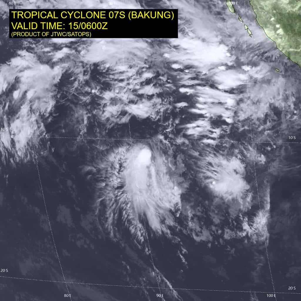
Tropical Cyclone 07S (Bakung)
According to the JTWC warning number 8, sustained winds are 50 knots with 65 knot gusts
Animated multispectral satellite imagery (msi) depicts a highly asymmetric circulation with a partially exposed low level circulation center (llcc) situated in the northeastern edge of an area of disorganized convection. Animated water vapor imagery shows an area of relatively dry mid-level air along the northeastern flank of the circulation and a sharp upshear cloud edge, facing the northeasterly shear.
Environmental conditions have deteriorated significantly over the past day, with strong deep layer northeasterly shear, and dry air intruding to the north, offsetting the strong poleward outflow and warm ssts.
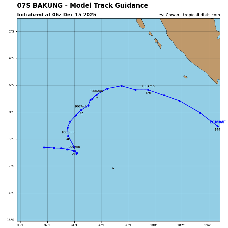
Tropical cyclone 07S continues to drift slowly eastward along the southern side of the ner to the north. This general motion is expected to continue for the next 24 hours as the ner remains entrenched along the equator west of Sumatra. However, as the system weakens after 24 hours, it will steadily come under the influence of the lower-level flow pattern, which will
push it onto a northward trajectory by the end of the forecast period.
In terms of intensity, TC 07S is forecast to steadily weaken through the forecast period due to persistently high northerly shear and dry air intrusion. The system is expected to dissipate as a tropical cyclone by 48 hours.
Southwest Pacific Ocean
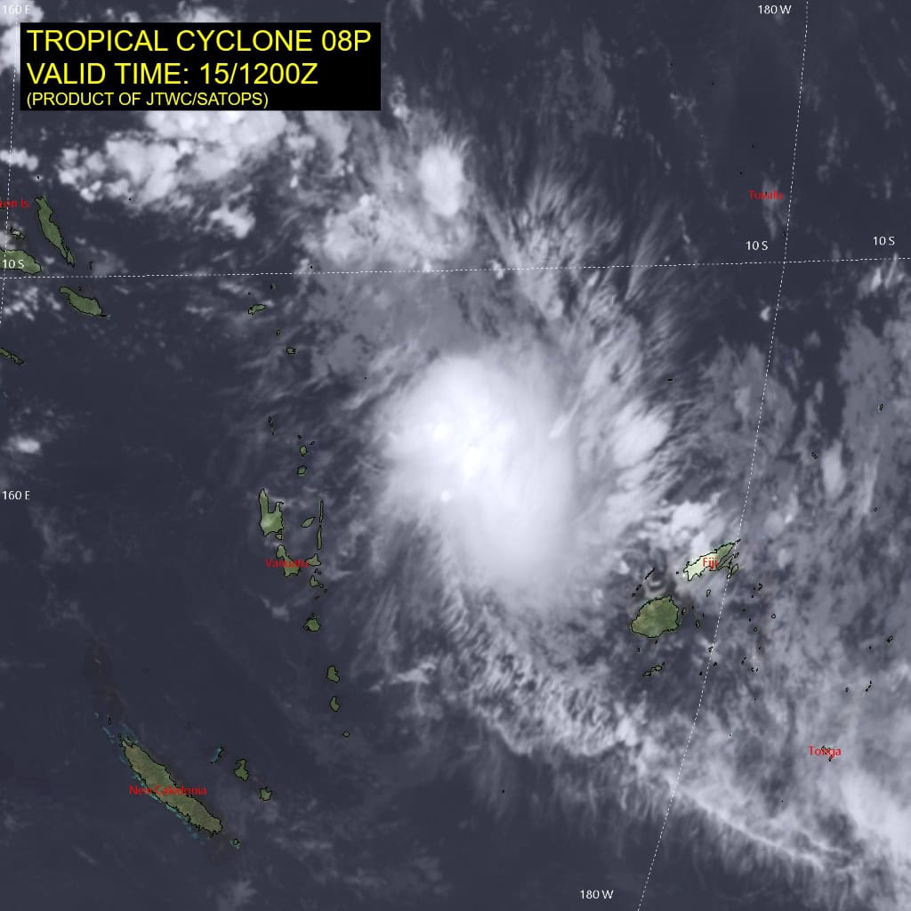
Tropical Cyclone 08P
According to the JTWC warning number 5, sustained winds are 40 knots with 50 knot gusts
Animated enhanced infrared (eir) satellite imagery depicts a compact, asymmetric system, with an elongated region of persistent, but now weakening, convection to the east of the assessed low level
circulation center (llcc). A very small region of developing convection appears to be developing near the assessed center but it remains to be seen if this will persist. A 150930z ascat-b pass revealed a very small llcc and a highly asymmetric wind field, with 30-35 knot winds restricted to an arc on the eastern flank of the circulation. The accompanying mhs 89ghz microwave image revealed a disorganized area of convection displaced to the east of the llcc, which based on the latest eir imagery appears to be stretching out along a northwest-southeast axis.
The environment remains marginally favorable, with moderate northwesterly shear offsetting the strong poleward outflow and warm ssts.
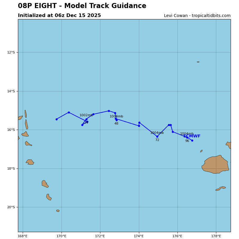
Tropical cyclone 08P has, as expected, steadily turned from a southeastward to a more eastward
trajectory over the course of the last day, as it moves under the building ridge to the north. While the overall track direction is not much in doubt in the short-term, the speed of advance is very much in doubt. Track models are broken into two distinct camps, with the european models (ecmwf, egrr, eceps) developing a very weak system, which results in a weak steering gradient and a very slow course towards the east, one which never even reaches Fiji. The u.s. models (gfs, gefs, and the mesoscale models) on the other hand develop a much stronger system, with a correspondingly
stronger steering gradient, resulting in a much faster eastward track, which pass south of American Samoa before turning poleward.
A lot depends on how the models are initializing, and it appears that neither the gfs nor the ecmwf are doing a good job on this front. The gfs is too strong and symmetrical compared to the scatterometer, while the ecmwf is too weak. with so much uncertainty, the forecast is relying on consistency and persistence, walking back a bit from the more aggressive gfs solutions, but also moving far out in front of the european model solutions.
In terms of intensity, again its a tale of two completely different outcomes. The european models, being slower, bring the system under a jet stream early in the forecast, which kills the system within 24 to 36 hours. In the gfs solution, this process is delayed until 36 to 48 hours. If the system does move out to the east as expected, then it will have a short window of marginally favorable conditions, where it could intensify a bit, before it is hammered by increased shear and dry air, which will lead to its demise by 72 hours.
South Indian Ocean
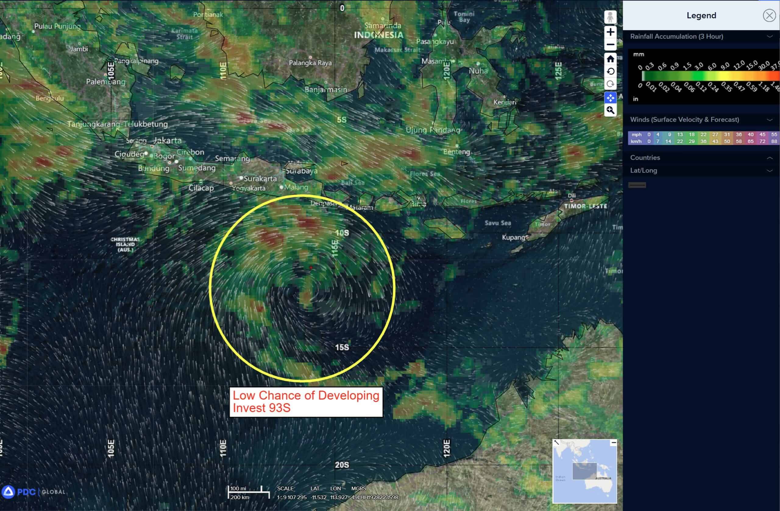
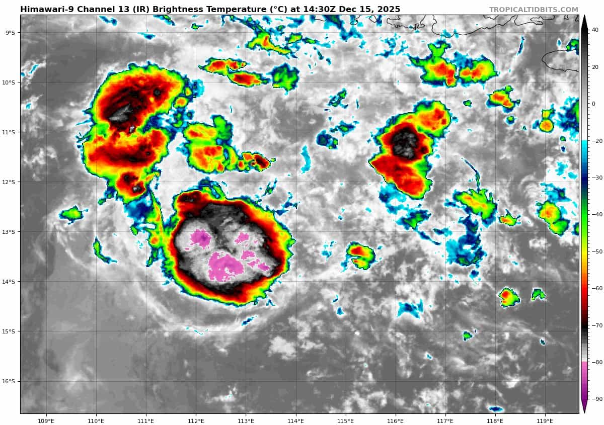
>>> There’s an area of disturbed weather being referred to as Invest 93S, which is located approximately 443 NM east-southeast of Christmas Island
Animated enhanced infrared (ir) imagery depicts an exposed low-level circulation center with shallow
and diffuse convection. A 141313z metop-b ascat image revealed swaths of 15-20 knot winds along the far northern and western peripheries of the circulation.
Environmental analysis depicts a marginally favorable environment for development with fair poleward upper level outflow, low vertical wind shear (5 to 10 kts), and warm sea surface temperatures (28 to 29 c). The main hindrance for the system is dry air entrainment from the south and west.
Global models show 93S staying quasi-stationary as it begins to consolidate over the next few days before tracking generally westward. GFS is the first to consolidate the system while the other deterministic models are more hesitant.
Maximum sustained surface winds are estimated at 15 to 20 knots.
The potential for the development of a significant tropical cyclone within the next 24 hours is low.