
")
Current Snapshot
For all the latest updates visit: DisasterAWARE

1800×1080
bakung
07S_140600sair
07S_tracks_latest
08P
08P_141200sair
08P_tracks_latest
93s
himawari9_ir_93S_202512141500_lat-13.4-lon113.1
93S_tracks_latest
By PDC’s Senior Weather
Specialist Glenn James

The Pacific Disaster Center’s (PDC Global) Sunday, December 14, 2025, Tropical Cyclone Activity Report…for the Pacific Ocean, the Indian Ocean, and adjacent Seas
Current Tropical Cyclones:
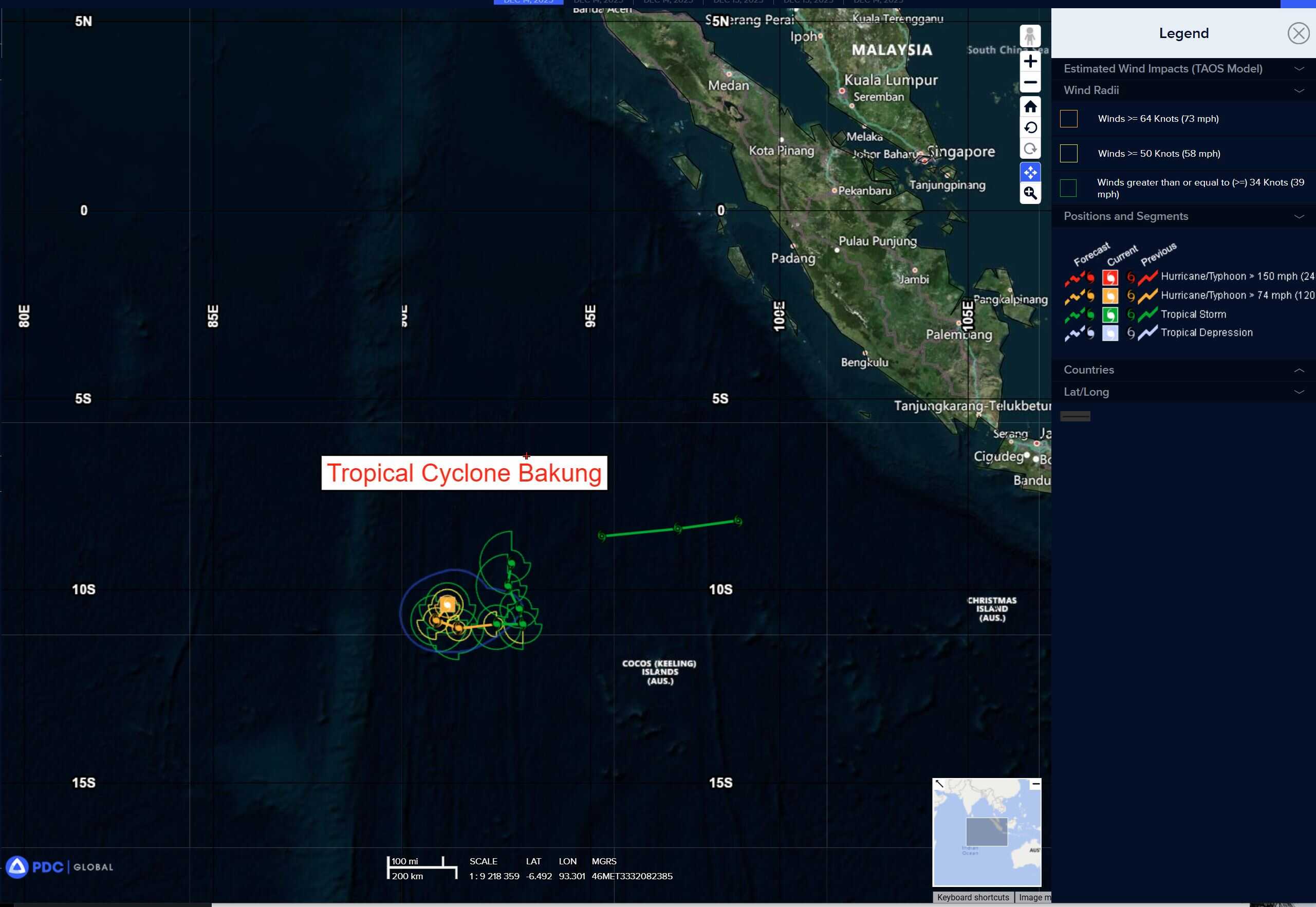
Tropical Cyclone 07S (Bakung) is located approximately 361 NM west-northwest of the Cocos Islands
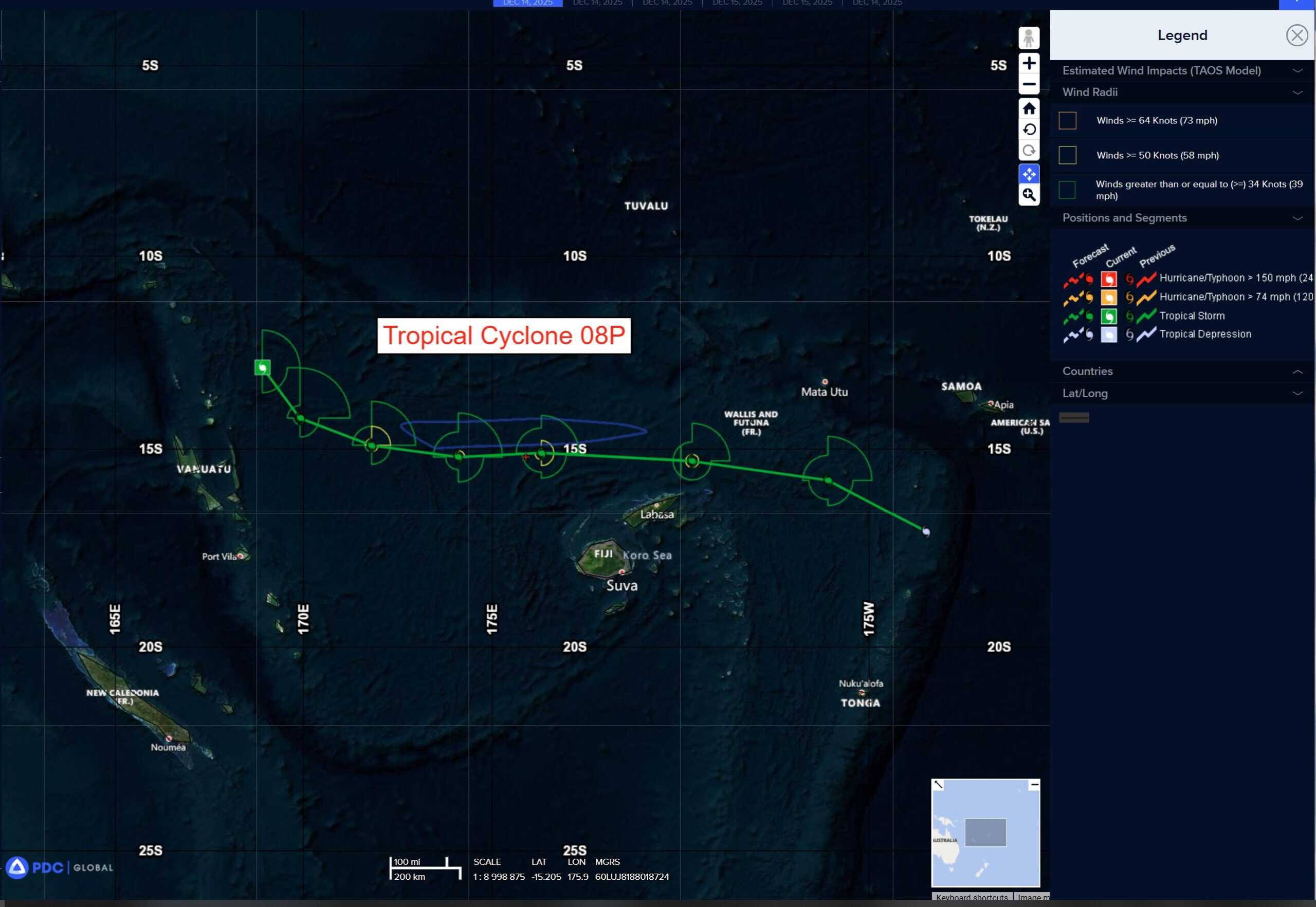
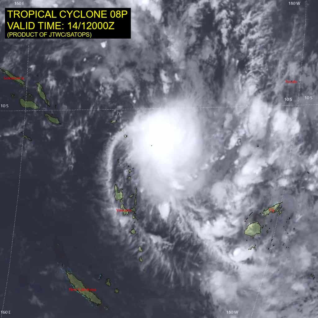
Tropical Cyclone 08P is located approximately 266 NM north-northeast of Port Vila, Vanuatu
Northeast Pacific Ocean: There are no Tropical Cyclones
The last regularly scheduled Tropical Cyclone Activity Report of the 2025 eastern North Pacific Hurricane Season has been issued. Routine issuance of this section of the PDC product will resume on May 15, 2026. During the off-season, Special Tropical Weather Outlooks will be issued as conditions warrant by the NHC.
Central Pacific Ocean: There are no Tropical Cyclones
The 2025 central North Pacific hurricane season has ended. As such, the final routine Tropical Cyclone Activity Report for the 2025 season has been issued. Routine issuance of this section of the PDC product will resume on June 1, 2026. During the off-season, Special Tropical Weather Outlooks will be issued as conditions warrant by the CPHC.
Western Pacific, Indian Ocean, and adjacent Seas:
South Indian Ocean
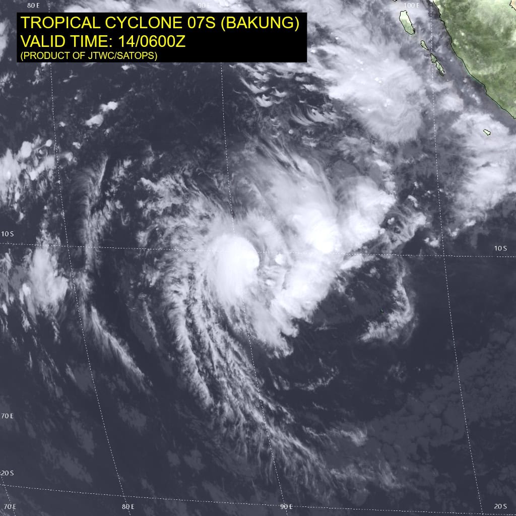
Tropical Cyclone 07S (Bakung)
According to the JTWC warning number 7, sustained winds are 70 knots with 85 knot gusts
Animated multispectral satellite imagery (msi) indicates a very compact tropical cyclone, with a small area of deep convection at
the head of a comma-shaped feature. Analysis of earlier enhanced
infrared (eir) imagery shows that the system briefly developed an
eye around 140000z, only to have it rapidly fill and the satellite
depiction has rapidly degraded ever since. The eir imagery also shows a very sharp eastern edge of the cirrus shield, consistent with
the model-based analysis of relatively strong deep-layer east-northeasterly shear.
Environmental conditions are marginally favorable, with moderate
easterly shear, moderate poleward outflow and warm ssts.
Tropical cyclone (TC) 07S has tracked southwestward at a steady clip over the past couple of days, along the western side of the ner which lies to the east of the system. However, the system is rapidly slowing down as an approaching trof moves in from the west and is eroding the ridge, weakening the steering gradient.
Over the next 12 hours or so, TC 07S will drift slowly towards the southwest under the influence of the rapidly weakening ridge to the east. The system reaches an inflection point by 12 hours and will be pushed eastward by the combined influence of the trof passing far to the south and a strengthening ner situated along the equator from Sumatra all the way to the Maldives. TC 07S will track eastward along the southern side of the ner through 48 hours, before it once again reaches an inflection point as the ner to the north begins to recede westward, while simultaneously a subtropical ridge (str) builds northwestward from western Australia and literally pushes TC 07S slowly northward.
In terms of intensity, the system has already peaked in intensity but looks to be able to resist the moderate easterly shear for a bit longer and maintain its current intensity. After it begins to turn eastward however, shear will increase further, and begin the slow but steady
weakening process, which will continue through the bulk of the
forecast period. Dry air will shoulder its way in around 48 hours,
helping to increase the pace of weakening.
However, by the end of the forecast, as the system moves northward, shear is expected to decrease, deep-layer moisture will increase as will ssts and the system could begin to recover by 120 hours. Due to the small nature of the system, significant and rapid changes in intensity are likely as the inner-core will be highly susceptible to small-scale changes in the environment.
Southwest Pacific Ocean
Tropical Cyclone 08P
According to the JTWC warning number 2, sustained winds are 40 knots with 50 knot gusts
Animated enhanced infrared (eir) satellite imagery depicts a compact and asymmetric central dense overcast (cdo) feature. The
cdo has warmed significantly over the past couple of hours, after having reached its zenith about four hours ago. Animated shortwave
infrared (swir) shows some hints of the outer low-level bands to the north of Vanuatu, which aligns reasonably well with a 141028z mhs 89ghz microwave image which showed the low level circulation
center (llcc) to be displaced west of the cdo feature.
The last sounding from Port Vila, Vanuatu (0000z) indicated strong winds at the 300mb level pushing in from the west, which is at odds with the model derived soundings, but would make sense compared to the satellite depiction.
Environmental conditions are generally favorable, with low deep-layer shear, warm ssts and strong poleward outflow.
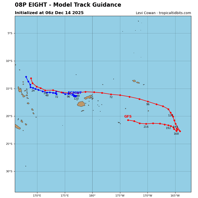
Tropical cyclone (TC) 08P (eight) has tracked southeastward along the western side of a deep-layer, east-west oriented ner, centered near western Samoa, for the past day or so. This general motion is expected to continue for the next 12-18 hours before the system gradually turns onto a more eastward trajectory as the ridge moves north and elongates towards the west. TC 08P will track east along the southern side of this ridge through 96 hours, and then as it weakens and comes under the influence of the lower-level steering flow, turns southeastward by the end of the forecast period.
In terms of intensity, the main hindrance in the near-term will be the asymmetric nature of the vortex, brought on the moderate to high mid-level westerly shear. The models are not handling this system well at all, and thus the forecast of the shear and the resulting timing of vortex alignment is highly uncertain. Assuming the best-case scenario as depicted by the GFS, deep-layer shear should remain low, while mid-level shear decreases sharply, allowing the vortex to symmetrize in short order.
If this scenario plays out, the system should steadily intensify over the next 36 to 48 hours. After 48 hours, the system moves close enough to the jet stream to the south to feel an increase in shear, which will offset the robust outflow into the jet max and will begin to rapidly weaken through the remainder of the forecast period. TC 08P is forecast to dissipate by 120 hours, southwest of American Samoa.
South Indian Ocean
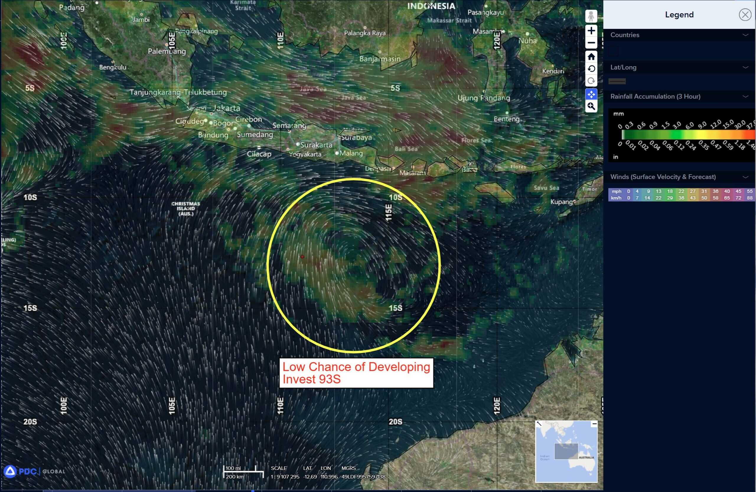
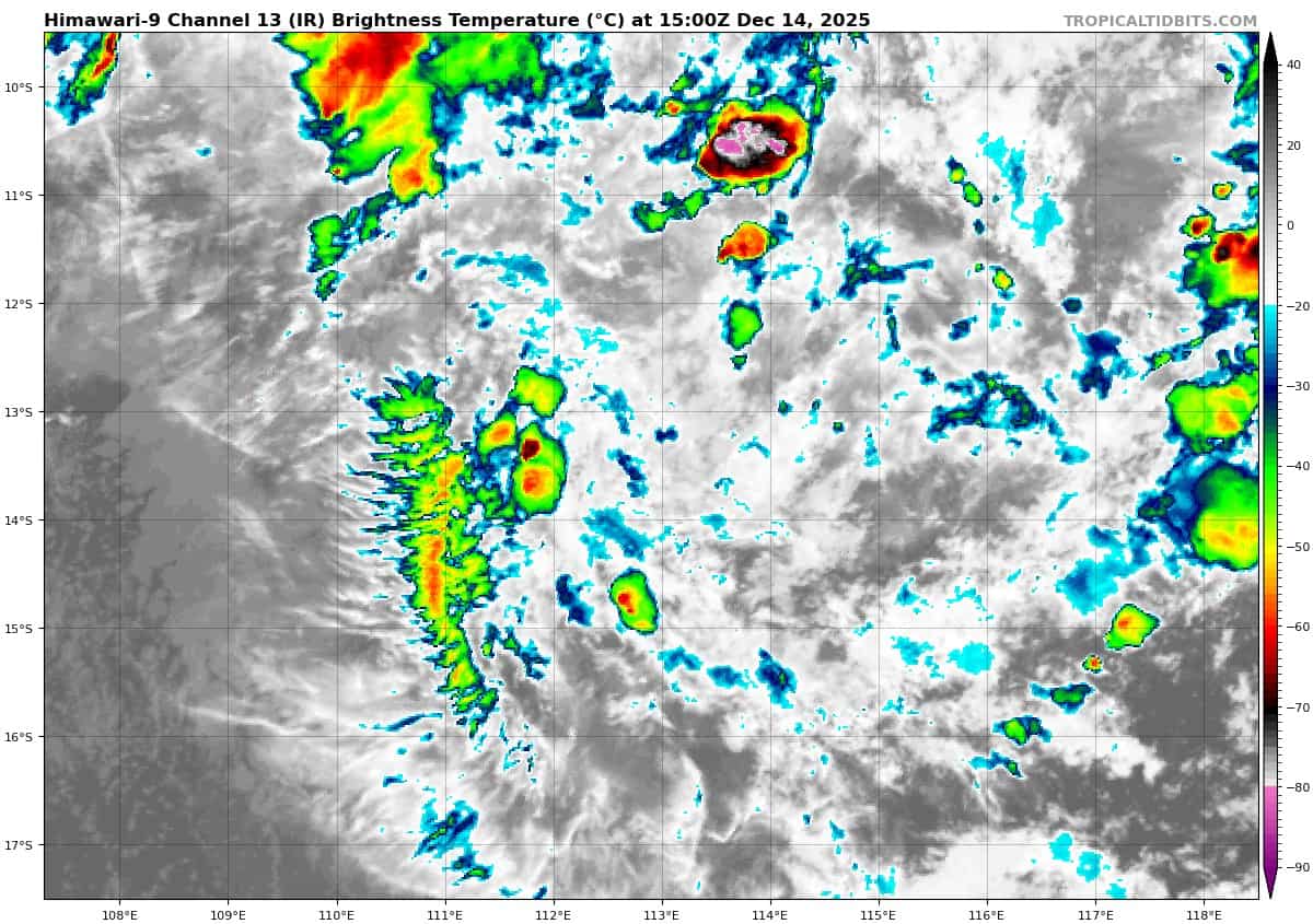
>>> There’s an area of disturbed weather being referred to as Invest 93S, which is located approximately 443 NM east-southeast of Christmas Island
Animated multispectral satellite imagery and a 121808z amsr2 89 ghz microwave image depict a consolidating partially exposed low-level circulation center with flaring convection along the southwestern periphery.
Environmental analysis shows a marginally favorable environment with strong poleward outflow aloft, low to moderate vertical wind shear (15 to 20 kts), and warm sea surface temperatures (28 to 29 c).
Global models agree on 93S staying quasi-stationary as the system slowly starts to develop and condense over the next few days.
Maximum sustained surface winds are estimated at 15 to 20 knots.
The potential for the development of a significant tropical cyclone within the next 24 hours remains low.