
")
Current Snapshot
For all the latest updates visit: DisasterAWARE
epac
1800x1080e
06w
06W_111200sair
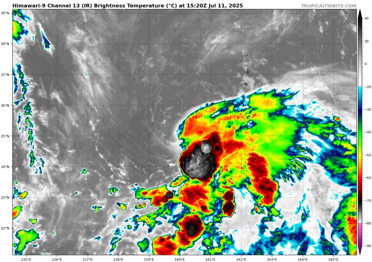
himawari9_ir_06W_202507111520_lat25.1-lon140.2

06W_tracks_latest
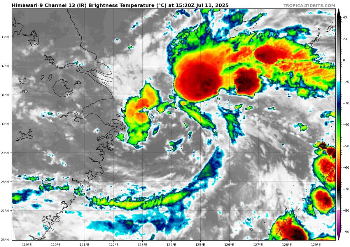
himawari9_ir_92W_202507111520_lat29.7-lon124.6
By PDC’s Senior Weather
Specialist Glenn James

The Pacific Disaster Center’s (PDC Global) Friday, July 11, 2025, Tropical Cyclone Activity Report…for the Pacific Ocean, the Indian Ocean, and adjacent Seas
Current Tropical Cyclones:
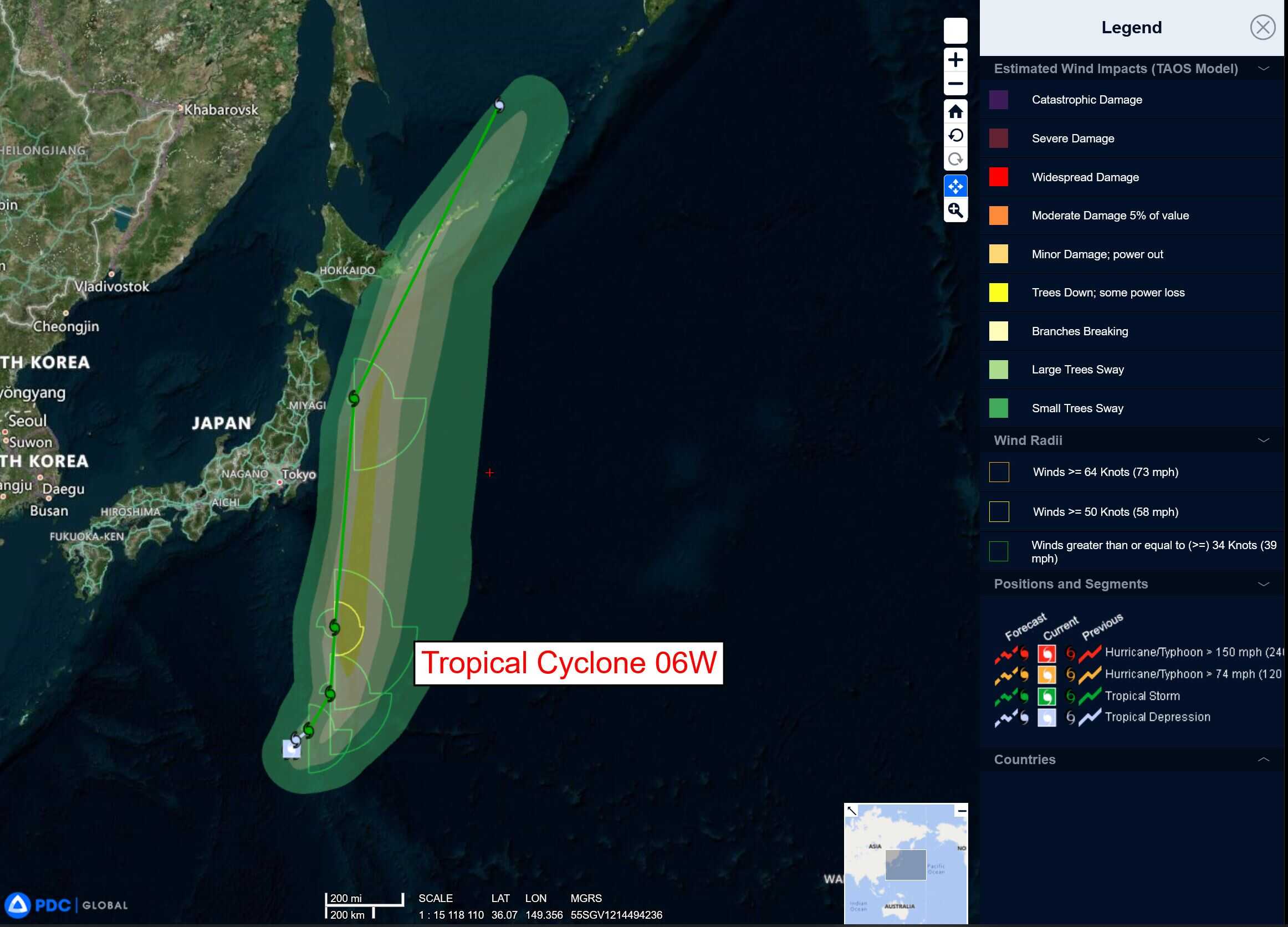
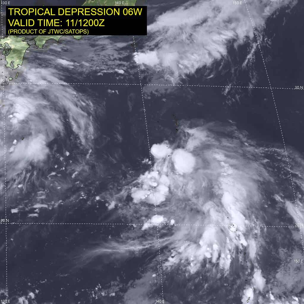
Tropical Cyclone 06W is located approximately 50 NM west-northwest of Iwo To
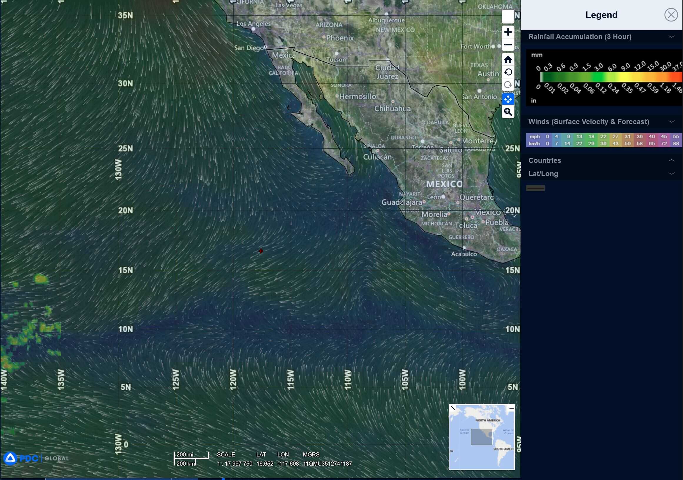
Northeast Pacific Ocean: There are no Tropical Cyclones
Tropical cyclone formation is not expected during the next 7-days.
Central Pacific Ocean: There are no Tropical Cyclones
Tropical cyclone formation is not expected during the next 7-days.
Western Pacific, Indian Ocean, and adjacent Seas:
Western Pacific
Tropical Cyclone 06W
According to the JTWC Warning number 5, sustained winds were 35 knots with gusts to near 45 knots
Animated enhanced infrared imagery reveals that tropical depression 06W remains quasi-stationary. the initial position is assessed with high confidence based on a well-defined, predominantly exposed low-level circulation center (llcc) apparent in the infrared imagery, as well as a 111159z metop-b ascat pass.
Increasing and moderate (15-20 knot) northwesterly vertical wind shear (vws) is pushing the central convection towards moderately strong equatorward outflow channel. the aforementioned ascat pass also reveals an asymmetric wind field structure, with maximum winds present throughout the eastern semicircle of the circulation. The system continues to lack sustained deep convection over the llcc, likely due to the suppressive influence of an upper-tropospheric trough positioned directly aloft.
Additional environmental analysis suggests marginally favorable conditions for development. deep-layer moisture content remains moderate to high, sea surface temperatures are warm, and the system lies just north of an upper-level diffluent zone enhancing equatorward outflow.
TD 06W remains quasi-stationary due to its position within a synoptic col region, bounded by subtropical ridging to the northwest, southwest and east of the system. Consequently, the system is expected to exhibit minimal translation over the next 24 hours as the steering pattern gradually evolves. Around 24 hours, the subtropical ridge (str) to the east is forecast to build significantly and assume the primary steering, facilitating a gradual northward acceleration of the system.
Intensity is projected to increase modestly, peaking around 50 knots by 48 hours. However, further intensification will likely be constrained by progressive entrainment of dry mid-level air into the core circulation. Beyond 72 hours, the system will begin to interact with an approaching mid-latitude long wave trough, leading to increased baroclinic forcing. Extra-tropical transition is anticipated to commence around 72 hours and complete by 96 hours, as the system becomes embedded within the mid-latitude flow.
>>> There’s an area of disturbed weather, which is being referred to as Invest 92W, and is located approximately 117 NM west of Shanghai, China
Animated multi-spectral satellite imagery (msi) imagery depicts a fully exposed low level circulation center (llcc), with persistent flaring convection along the eastern and southern periphery of the circulation. A partial ascat-b pass reveals a broad, elongated, and asymmetric cyclone with strong winds wrapping around the circulation.
Environmental analysis shows marginal to favorable conditions for development with low (10-15 knots) vws, good
to moderate outflow and warm sea surface temperature.
Global models are in agreement that Invest 92W will take a northeastern track into colder waters over the next 24-36 hours.
Maximum sustained surface winds are estimated at 22 to 28 knots.
The potential for the development of a significant tropical cyclone within the next 24 hours is upgraded to medium.