
")
Current Snapshot
For all the latest updates visit: DisasterAWARE

epac2
goes18_barb

02E_tracks_latest
goes18_cosme

03E_tracks_latest
cpac
1200×1200
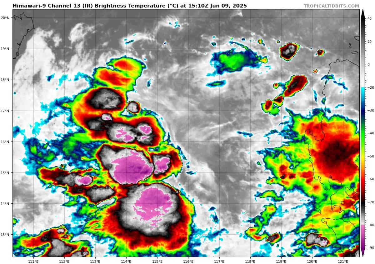
himawari9_ir_92W_202506091510_lat16.3-lon116.2

92W_tracks_latest
By PDC’s Senior Weather
Specialist Glenn James

The Pacific Disaster Center’s (PDC Global) Monday, June 9, 2025, Tropical Cyclone Activity Report…for the Pacific Ocean, the Indian Ocean, and adjacent Seas
Current Tropical Cyclones:
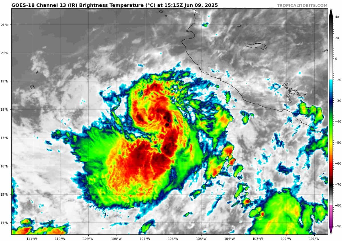
Tropical Cyclone (02E) Barbara…is located about 230 miles west of Manzanillo, Mexico
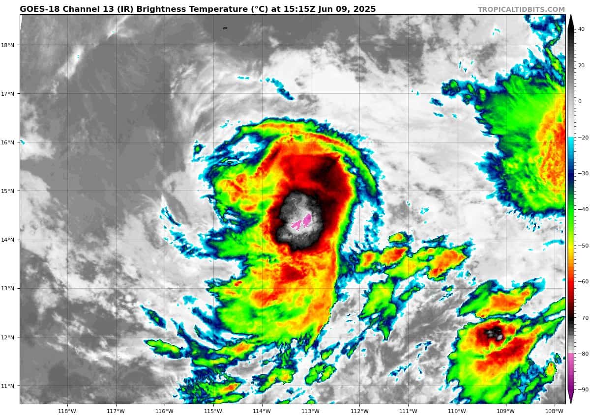
Tropical Cyclone 03E (Cosme)…is located about 600 miles south-southwest of the southern tip of Baja CA
Northeast Pacific Ocean:
Tropical Cyclone 02E (Barbara)
BARBARA NOW A TROPICAL STORM
According to the NHC advisory number 8
Barbara is moving toward the northwest near 12 mph (19 km/h), and this general motion is expected during the next day or so followed by a gradual westward turn. Maximum sustained winds have decreased to near 70 mph (110 km/h) with higher gusts. Continued weakening is forecast, and the system is forecast to become a remnant low by Wednesday. Tropical-storm-force winds extend outward up to 80 miles (130 km) from the center.
HAZARDS AFFECTING LAND
SURF: Swells generated by Barbara will affect portions of the coast of southwestern Mexico during the next day or so. These swells are likely to cause life-threatening surf and rip current conditions.
WIND: Gusty winds are likely along coastal areas of southwestern Mexico tonight.
Tropical Cyclone 03E (Cosme)
COSME COULD STILL BECOME A HURRICANE OVERNIGHT BEFORE WEAKENING BEGINS LATER ON TUESDAY
According to the NHC advisory number 7
Cosme is moving toward the northwest near 3 mph (6 km/h). A turn toward the north is expected by early Tuesday, followed by a faster north-northeast motion late Tuesday through Wednesday. Maximum sustained winds remain near 70 mph (110 km/h) with higher gusts. Cosme could still become a hurricane overnight before weakening begins later on Tuesday. Cosme is forecast to become a post-tropical remnant low in a couple of days. Tropical-storm-force winds extend outward up to 60 miles (95 km) from the center.
South of southern Mexico
>>> An area of low pressure is forecast to develop later this week south of southern Mexico. Environmental conditions appear conducive for gradual development of this system, and a tropical depression is likely to form late this week or over the weekend.
* Formation chance through 48 hours…low…near 0 percent
* Formation chance through 7 days…high…70 percent
Central Pacific Ocean: There are no Tropical Cyclones
Tropical cyclone formation is not expected during the next 7-days.
Western Pacific, Indian Ocean, and adjacent Seas: There are no Tropical Cyclones
Western Pacific
>>> There’s an area of disturbed weather being referred to as Invest 92W, which is located approximately 334 NM west of Manila
Animated multi-spectral satellite imagery (msi) depicts an exposed low level circulation center (llcc), with flaring convection near the llcc. A partial microwave image shows a closed circulation with the strongest winds (approximately 20 knots) in the southern portion of the invest.
Environmental analysis reveals marginally favorable conditions for development with good equatorward upper-level outflow, warm sea surface temperatures (sst), and low to moderate wind shear (15-20 knots).
Deterministic and ensemble models are in good agreement that 92W will steadily develop while tracking towards the northwest over the next 24 hours.
Maximum sustained surface winds are estimated at 18 to 23 knots.
The potential for the development of a significant tropical cyclone within the next 24 hours remains medium.