Western Pacific, Indian Ocean, and adjacent Seas:
Western Pacific

")

By PDC’s Senior Weather
Specialist Glenn James

The Pacific Disaster Center’s (PDC Global) Thursday, October 9, 2025, Tropical Cyclone Activity Report…for the Pacific Ocean, the Indian Ocean, and adjacent Seas
Current Tropical Cyclones:
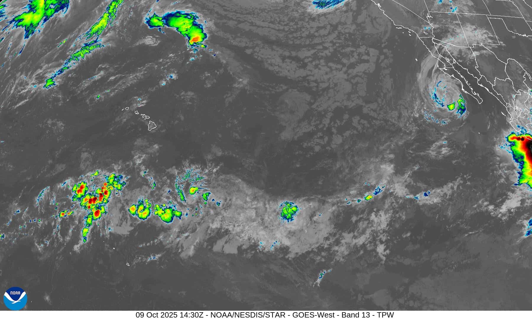
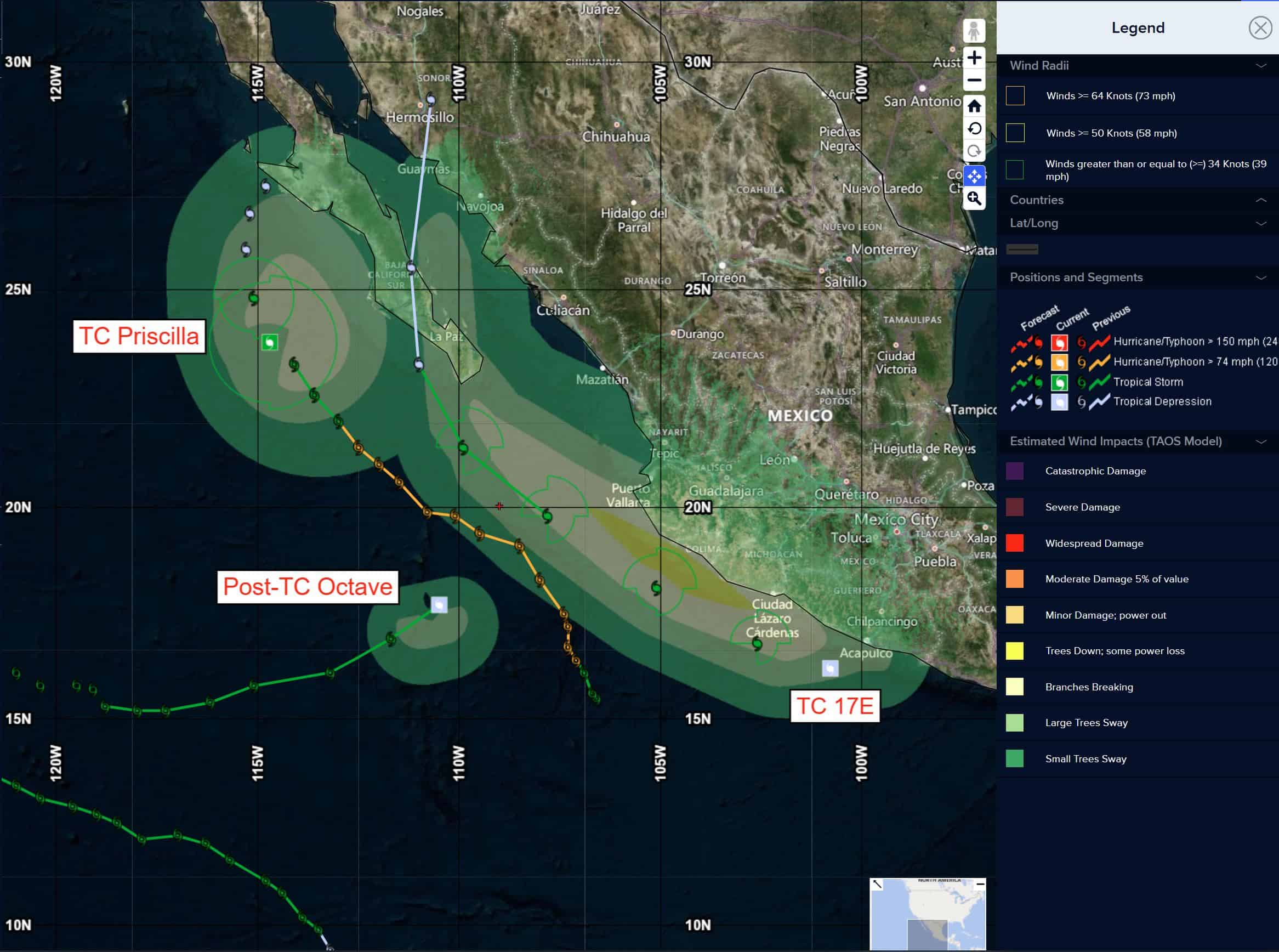
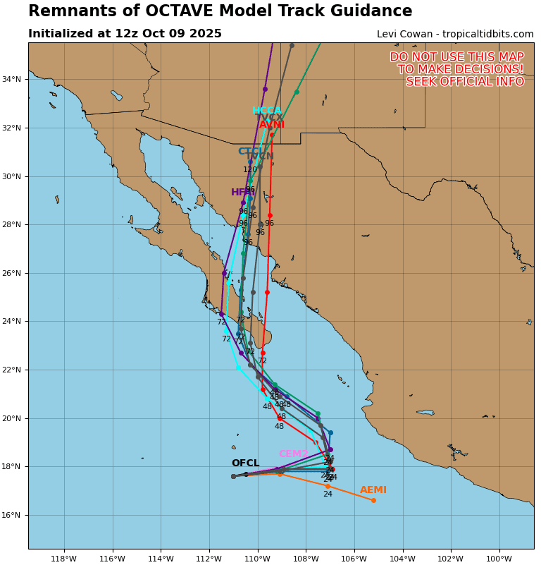
Post-Tropical Cyclone 15E (Octave) is located about 360 miles south of the southern tip of Baja California – Last Advisory
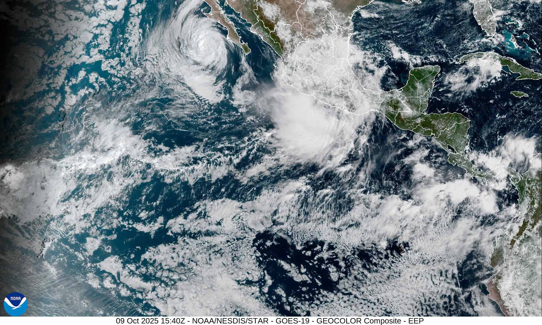
Tropical Cyclone 16E (Priscilla) is located about 1655 miles west-southwest of Cabo San Lazaro, Mexico
Tropical Cyclone 17E is located about 750 miles southeast of the southern tip of Baja California
Tropical Cyclone 28W (Halong) is located approximately 356 NM east-southeast of Yokosuka, Japan
Tropical Cyclone 29W (Nakri) is located approximately 368 NM east-southeast of Kadena AB
Northeast Pacific Ocean:
Post-Tropical Cyclone 15E (Octave) – Last Advisory
OCTAVE BECOMES A POST-TROPICAL CYCLONE
According to the NHC advisory number 38
The post-tropical cyclone is moving toward the east-northeast near 17 mph (28 km/h). This motion will continue until the system dissipates into an open trough later today. Maximum sustained winds have decreased to near 35 mph (55 km/h) with higher gusts. The system is expected to continue to weaken and dissipate into an open trough later today. The estimated minimum central pressure is 1006 mb (29.71 inches).
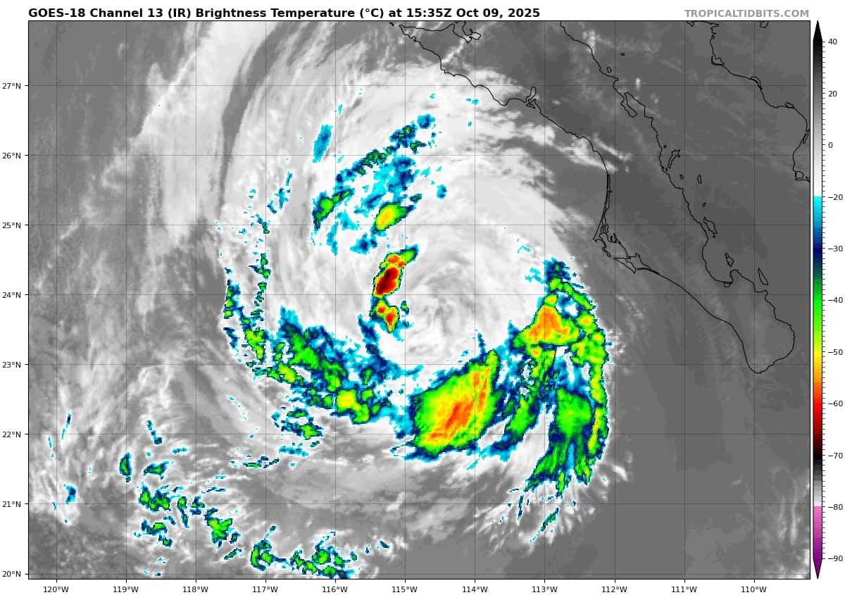
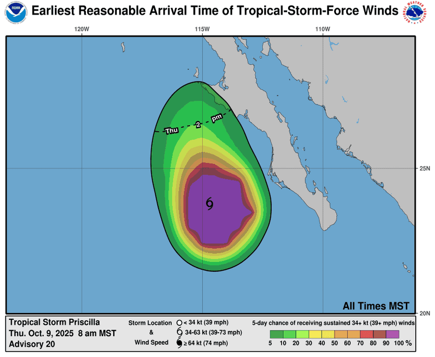
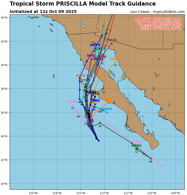
Tropical Cyclone 16E (Priscilla)
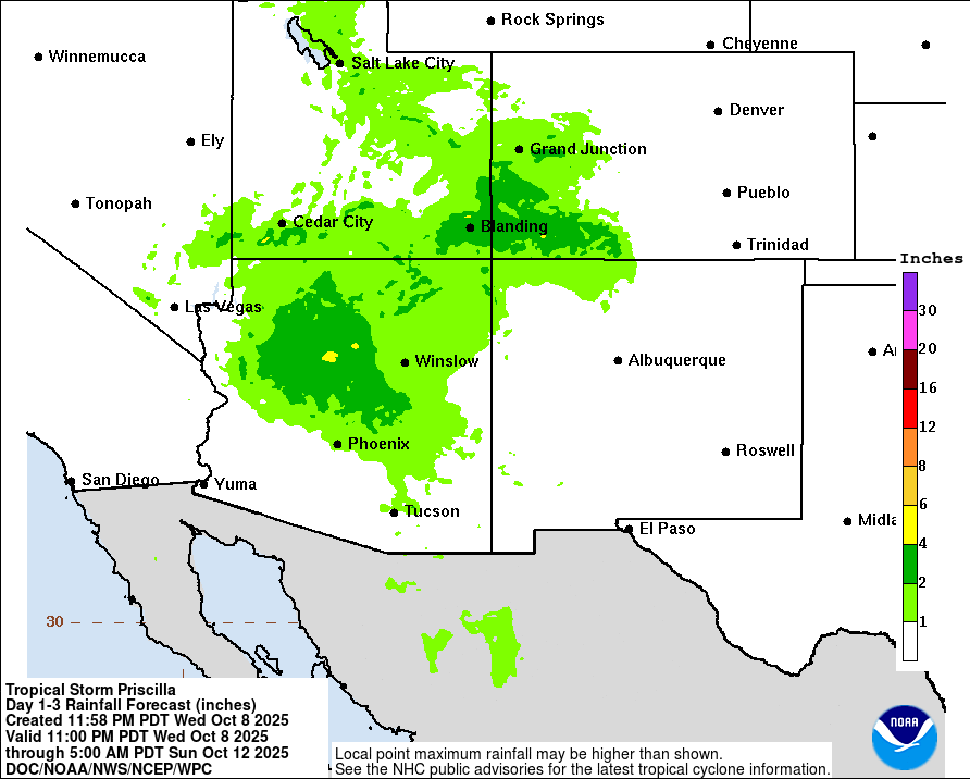
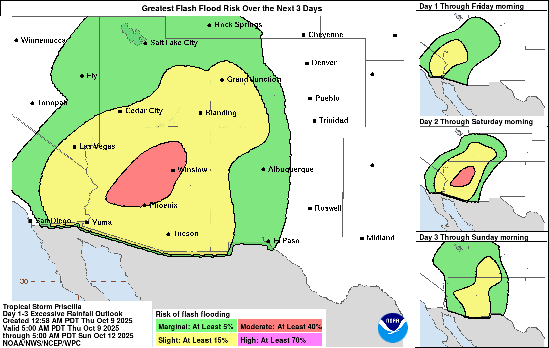
PRISCILLA WEAKENS A LITTLE MORE…SIGNIFICANT RISK OF FLASH FLOODING ACROSS THE SOUTHWEST UNITED STATES THROUGH THE WEEKEND
According to the NHC advisory number 20
Priscilla is moving toward the north-northwest near 8 mph (13 km/h). A turn toward the north is anticipated later today and tonight. On the forecast track, the center of Priscilla is expected to move parallel to, but offshore of, the coast of Baja California Sur. Maximum sustained winds have decreased to near 45 mph (75 km/h) with higher gusts. Weakening is forecast, and Priscilla is expected to become a post-tropical cyclone by Friday. Tropical-storm-force winds extend outward up to 115 miles (185 km) from the center. The estimated minimum central pressure is 996 mb (29.42 inches).
HAZARDS AFFECTING LAND WIND:
WIND: Gusty winds will be possible along the west coast of Baja California Sur today.
RAINFALL: As Priscilla moves off the west coast of Baja California, up to an inch of rain is expected across the Baja California peninsula. For the southwestern United States, 2 to 4 inches of rain, with local storm total maxima to 6 inches, are expected across portions of central and northern Arizona, southern Utah, and southwest Colorado through Saturday. Flash flooding is likely in portions of central Arizona, with scattered areas of flash flooding expected across the remainder of Arizona, southern Utah, southwest Colorado, and far northwest New Mexico.
SURF: Large swells generated by Priscilla are affecting the Pacific coast of Baja California Sur as well as portions of coastal southwestern and west-central Mexico. These swells are likely to cause life-threatening surf and rip current conditions, in addition to some coastal flooding.
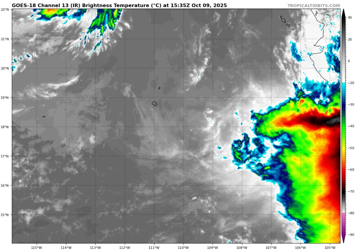
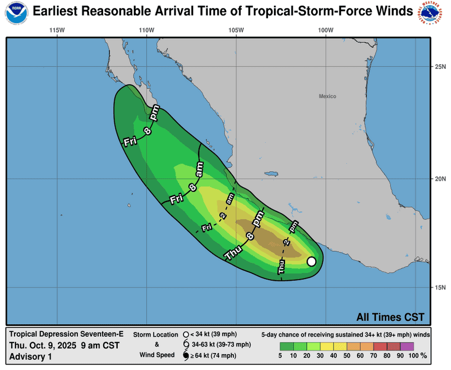
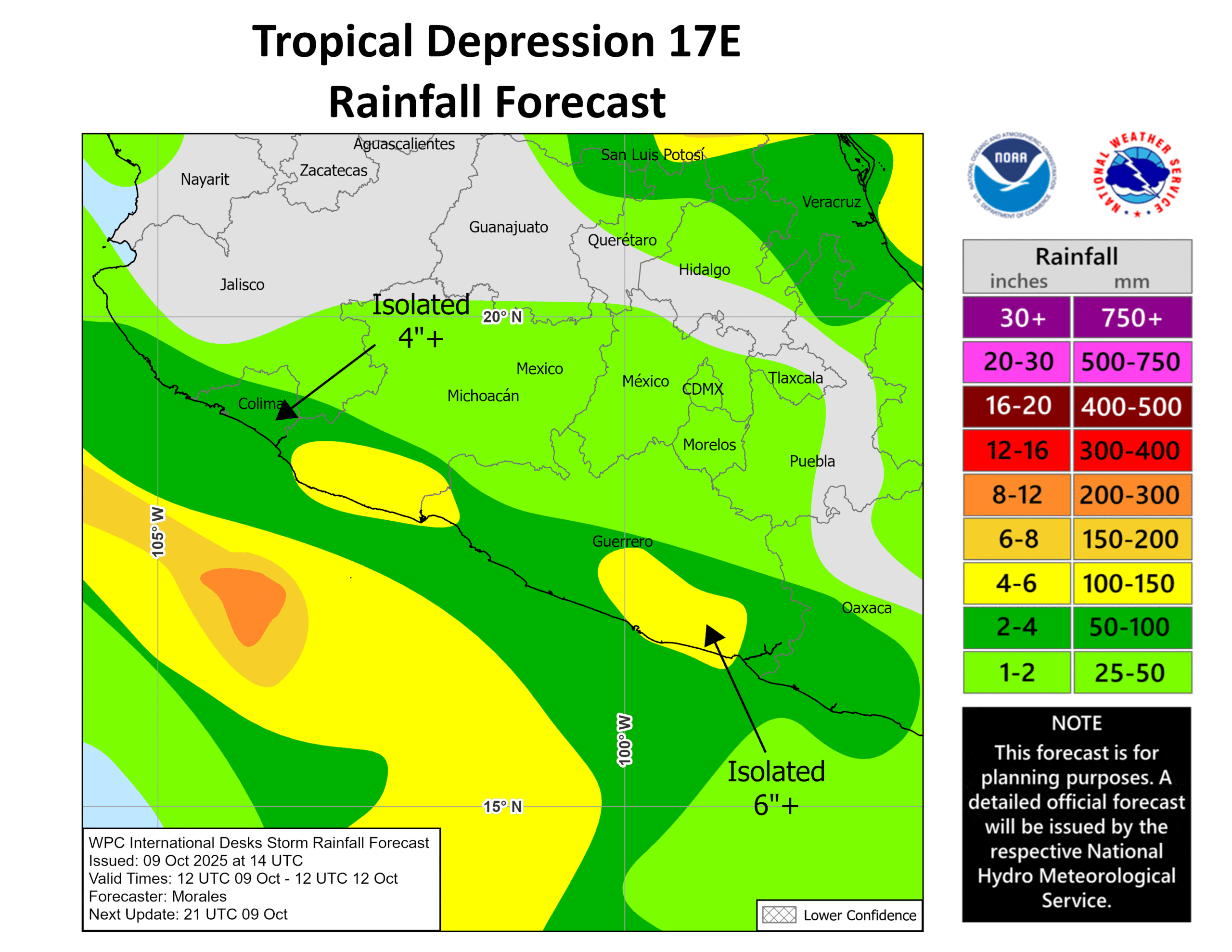
Tropical Cyclone 17E
TROPICAL DEPRESSION FORMS OFF THE COAST OF SOUTHWESTERN MEXICO…TROPICAL STORM WATCHES IN EFFECT
According to the NHC advisory number 1
The depression is moving toward the west-northwest near 14 mph (22 km/h), and this general motion is expected to continue through early Friday. A turn toward the northwest is expected by late Friday, followed by a northward turn by early Sunday. On the forecast track, the center of the depression is expected to move parallel to the southwestern coast of Mexico through Friday and then be near southern Baja California Sur Saturday and Sunday. Maximum sustained winds are near 35 mph (55 km/h) with higher gusts. Some strengthening is forecast through Friday, but weakening is likely over the weekend. The estimated minimum central pressure is 1004 mb (29.65 inches).
HAZARDS AFFECTING LAND
WIND: Tropical storm conditions are possible within the eastern part of the watch area later today and could spread westward across the remainder of the area through late Friday.
RAINFALL: Outer bands from the tropical depression will bring heavy rain to portions of southwestern Mexico through Saturday. Across coastal portions of Oaxaca, Guerrero, Michoacán, Colima, and Jalisco, rainfall amounts of 2 to 4 inches are expected, with local amounts of 6 inches or more in Guerrero and Michoacán. This rainfall will bring a risk of flash flooding, especially in areas of higher terrain. Moisture from the tropical depression will bring the potential for additional heavy rainfall over portions of the Southwest U.S. early next week.
SURF: Swells generated by the depression are expected to spread westward along the southwestern coast of Mexico through Friday and reach southern Baja California Sur on Saturday.
Central Pacific Ocean: There are no Tropical Cyclones
Tropical cyclone formation is not expected during the next 7 days.
Western Pacific, Indian Ocean, and adjacent Seas:
Western Pacific
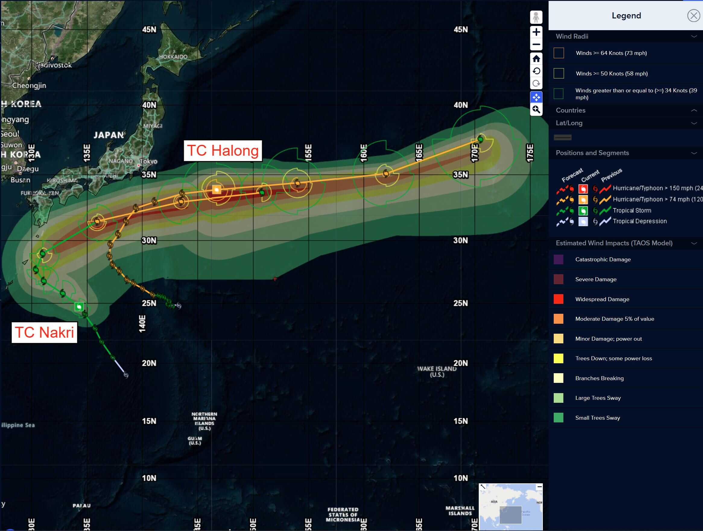
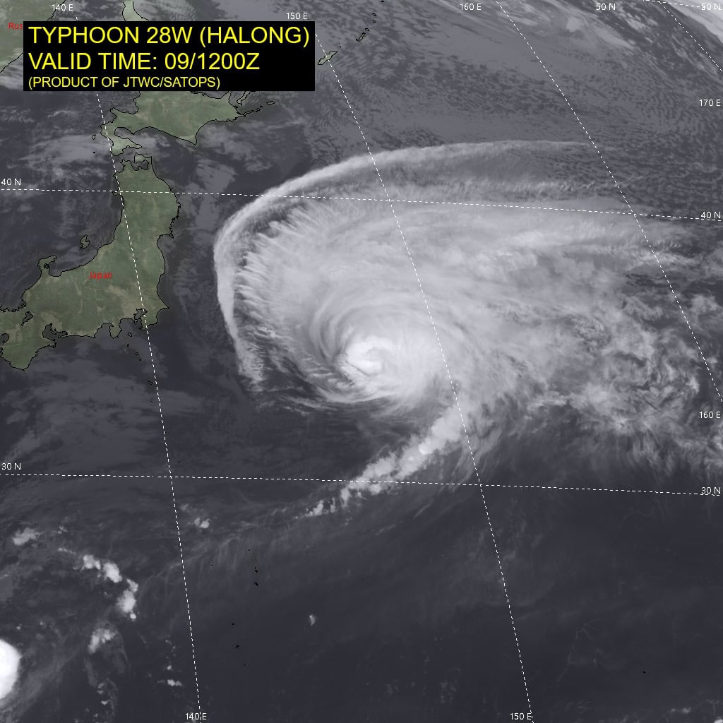
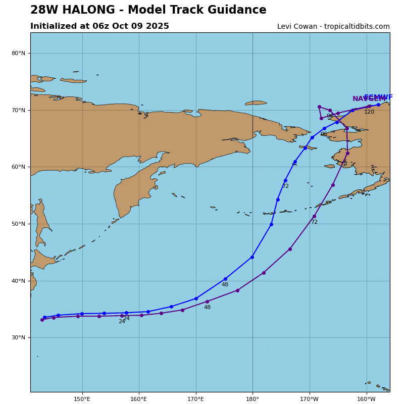
Tropical Cyclone 28W (Halong)
According to the JTWC warning number 21, sustained winds were 85 knots with gusts to 105 knots
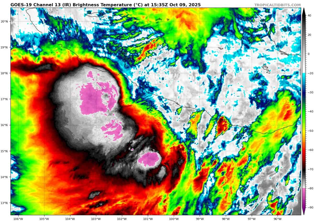
Animated enhanced infrared (eir) satellite imagery depicts what appears to be a well-organized typhoon, with a well-defined center, at least in the upper-levels. However, under the hood the story is different. A very timely 091140z ascat-c bullseye revealed that a significant amount of vortex decoupling is already underway, with the low level circulation center (llcc) displaced roughly 34 NM to the southwest of the center derived from the eir imagery and agency fix positions. Low resolution amsu-b 89ghz microwave imagery from 091102z shows a very weak and shallow inner-core of TY 28W and a broad outer band of moderate convection draped across the northern periphery of the circulation and what is likely a developing cold front well out in front of the system, curling down to the southwest.
Environmental conditions are rapidly deteriorating, with deep-layer shear now estimated to be 40 knots from the southwest, ssts are marginal at best, and dry air is beginning to encroach from the west. The only favorable aspect for the moment is the extremely strong poleward outflow.
Typhoon 28W (Halong) continues to accelerate as it races off to the east-northeast along the northern side of the deep str to the southeast. The ridge is expected to slide westward over the course of the forecast period, ending up in a position south of Tokyo, with a secondary ridge center developing near the dateline by the end of the forecast. TY 28W will track east-northeastward along the north side of ridge through 24 hours, then turn northeastward as it comes under the steering influence of the secondary ridge center.
The system is already starting to decouple, ahead of when the hafs-a and coamps-tc models thought this process would commence. Now that it has started, the decoupling process should be relatively quick. Dry air will quickly move in from the west and smother the lower-level vortex, while shear continues to increase and the system loses its energy source as it moves over cooler waters.
Simultaneously, TY 28W will begin extratropical transition (ett) as it begins to interact with the
mid-latitude westerlies and begins frontogenesis. Completion of ett is expected between 101800z and 110000z as the low-level vortex moves under the jet max begins to occlude.
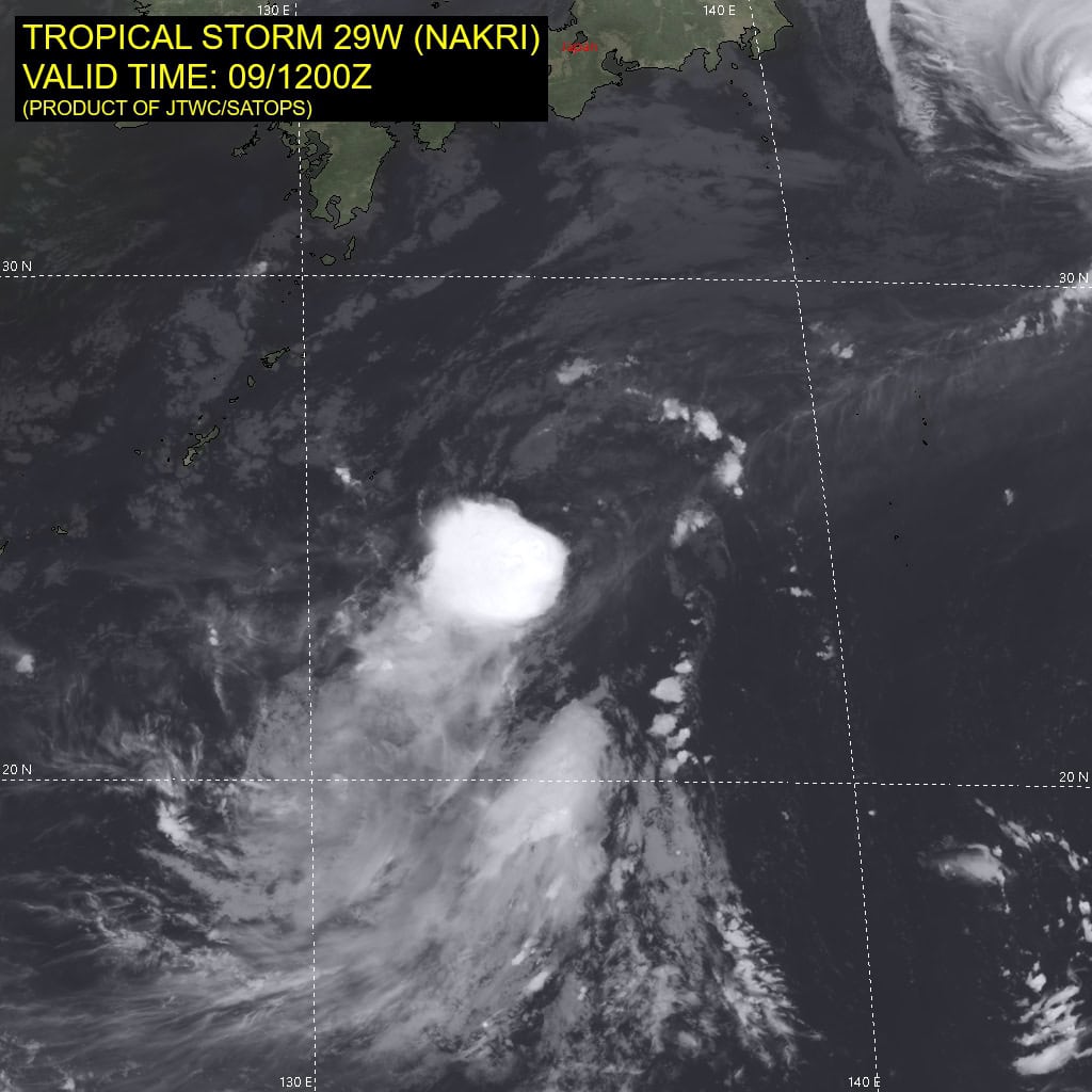
Tropical Cyclone 29W (Nakri)
According to the JTWC warning number 6, sustained winds were 35 knots with gusts to 45 knots
Animated enhanced infrared (eir) satellite imagery indicates that tropical storm 29W has shown a slight organizational improvement over the past six hours. The convection that was
displaced to the southwest at 0600z has persisted, organized into a small cdo feature and drifted northeastward under more favorable shear conditions. The cirrus associated with the cdo has obscured the low level circulation center (llcc) and the eir shows deep convection continuing to develop in close proximity to the assessed llcc, accompanied by an extreme burst in lightning activity.
A 091149z ascat-c bullseye shows an asymmetric wind field, with relatively light winds of 20-25 knots across the northern portion of the circulation and 35 knot winds mostly confined to the southern half of the system. A few 40 knot wind barbs were visible in the southwestern quadrant but these were rain flagged and being under the deepest convection, were deemed of questionable accuracy.
Environmental conditions are marginal though they are improving. SST are warm and shear has lowered significantly, down to just 10 knots as of 1200z. The main hinderance currently is the lack of a decent outflow mechanism and the presence of deep pockets of dry air, particularly to the west and north of the llcc, as indicated by the 1200z Minamidaitojima sounding which continues to show a very dry air mass above 750mb and light easterly winds above 300mb.
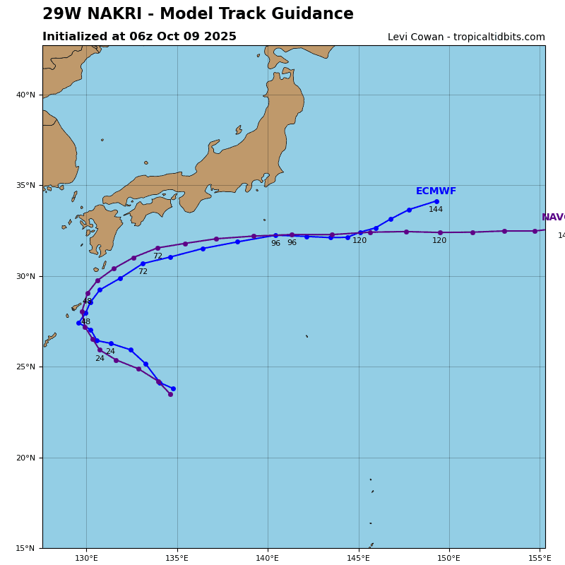
Tropical storm 29W has continued to track northwestward over the last six hours, though forward speed has slowed by half, down from 15 knots at 0600z to eight knots at 1200z. The reason for the slowdown is likely two-fold. First the steering gradient has weakened slightly and second, the system has wobbled a bit or undergone some vortex precession as it tucked under the deep convection to the south. However, there has been no change to the underlying steering pattern, with a deep str to the northeast, a secondary ridge centered over coastal China south of Shanghai and a col region due north of TS 29W.
Over the next 24 hours, the str to the east pushes west to a position south of Tokyo, while the
secondary ridge remains quasi-stationary. this will put a squeeze on TS 29wW, and the system will squirt out to the northwest into the col region to the north. Track speeds will remain relatively steady through 24 hours as the gradient tightens up a bit as the ridges squeeze ts 29W from both sides. TS 29W will slow down shortly after 24 hours as it nears the axis of the ridge and moves into the col region.
There remains a possibility of a short period of nearly quasi-stationary motion between 24 hours and 36 hours as the system moves through the col region and rounds the ridge axis. After 36 hours, both of the ridge centers remain stationary, but the global models indicate the eastern ridge builds and comes to dominate the steering influence for TS 29W with the tightest gradient placed on the southeastern side of the system. By 48 hours, TS 29W will have rounded the ridge, and accelerate towards the northeast along the northwestern side of the str. The track flattens to more of an easterly heading after 72 hours as the ridge moves to the west and itself flattens to a more east-west orientation.
In terms of intensity, the recent burst of convection will likely result in a small increase in intensity, though the none of the available model guidance depicts the convection persisting past convective max. As the system moves under the 200mb anticyclone to the north, it will be choked off from any significant outflow mechanism and is thus not expected to intensify much through 24 hours. As the system reaches and rounds the ridge axis, it will begin to tap into a
divergent poleward outflow channel, which combined with an increase in deep moisture, will allow for a period of near-rapid intensification between 48 and 72 hours.
The actual peak intensity of 80-85 knots will likely occur around 84 hours and is not captured in the forecast points directly. By 72 hours, the system will begin extratropical transition and begin to feel the effects of rapidly decreasing ssts, increasing shear and dry air entrainment, and start to rapidly weaken, continuing to weaken through the end of the forecast.